#the mapped lands
Photo
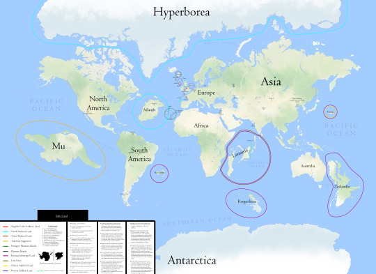
Mythical and Submerged land of the World.
by Breakingerr
3K notes
·
View notes
Text

Not my best work.
#I feel like all Pokemon have a natural fear of Legendaries/mythical pokemon#Like how in MHW monsters don't appear when an Elder is on the map (in regular quests the Guiding Lands is a different story.)#my art#pokemon#noibat#Pokémon but worse!
989 notes
·
View notes
Text
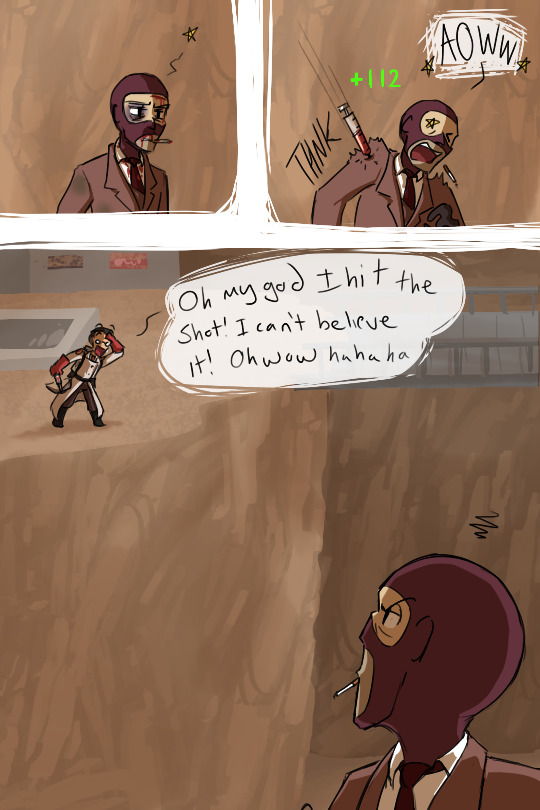
look i have to take my victories where i can get them okay
Spy didn't actually get hurt from the bolt (opposite in fact), he's just being dramatic lol
[patreon]
#team fortress 2#medic#spy#z art#z comic#i have terrible aim and my internet sucks#if i land ANY shots it's a victory#an occurance so rare that i still remember it lol#i forget the name of this map and i didn't look up a reference because i was lazy#i vaguely recall it looking like this though
821 notes
·
View notes
Text


Candy Land PC game, 1998
#candy land#candy#food#all I remember about this game is this part of the map and having a crush on the little peppermint guy and queen frostine#pc games#games#mine#original#90s#webcore
259 notes
·
View notes
Text
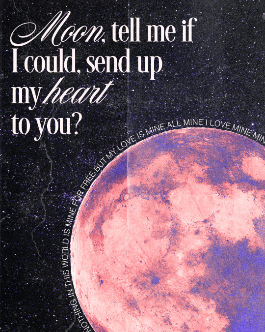
my baby here on earth, showed me what my heart was worth, so, when I die, which I must do, could it shine down here with you?
#mistki#the land is inhospitable and so are we#graphic design#art#lyric art#mitski art#my love mine all mine#originally had a coffee stain circling the moon to reference heaven but the gradient map muddied it and i liked the gradient to much to let#it go.#definitely wanted a slight 80s poster vibe with this. oh well.#stuff i made
888 notes
·
View notes
Text

Obviously, Dorothy didn't wear the exact same dress for her entire stay in Oz. She was there for roughly two months!
Nonestica is often the name given to the continent where Oz is located. A map first appeared in the 8th book, Tik-Tok of Oz. Many of the surrounding countries are from some of Baum's other non-Oz books. For instance, the forest of Burzee on the lower left is from The Life & Adventures of Santa Claus.

Now, this is a low resolution image, but if you're very clever, you may not have needed to read the compass rose to notice that east and west are reversed. Even people who have only ever seen the 1939 movie know the witch of the EAST enslaved the Munchkins and the witch of the WEST enslaved the Winkies.
Dick Martin and James Hoff later came up with an expanded version of the map that "corrected" the directions:

A lot of people like this one and I'm not an exception, but it wouldn't hurt to make the surrounding areas a little bigger.
Now, Robert A. Heinlein (yes, that Robert A. Heinlein) once proposed that the compass in the first map is flipped because Oz is on planet with a retrograde rotation. I love that explanation. It's canon to Yellow Brick Ramble.
So, I based the planet of Nonestica on all three of these interpretations with some tweaks of my own. I included a few other continents. One of them is called Tazara. I doubt all the lands on this planet are magical, as Oz is a special land. I did a little math and I'm guessing Oz is roughly 4 times the size of Kansas?
The planet of Earth, on the other hand, is one most of you are familiar with.
If you like my comics, please support me on Patreon (link in bio)
#dorothy gale#silver shoes#land of oz#kansas#nonestica#planet earth#maps#A reminder that this comic is not called Yellow Brick Brief & Concise News Posts
130 notes
·
View notes
Text

Oh baby baby
#what if you were the saddest and most overwhelmed autistic pony in all of the land#and then you had to be the princess and be in charge of everything and never got a break#what then huh#and then you outlive all of your friends#my art#map#twilight sparkle#mlp friendship is magic#fan art#my little pony friendship is magic
328 notes
·
View notes
Text
Reading physical copies of The Queen's Thief series for the first time and realizing that the maps in them are inconsistent???
#the only map i'd really seen before was K's map to P in Thick as Thieves#but now looking at the map from the last story of Moira's Pen I'm like. wait. the empire is opposite in this one.#like according to K's map C and K generally move west in TaT but the other map has them moving east#it's not that big a deal to me bc i had to read the entire series twice to conceptualize where anything was#(bc i spent the whole of The Thief not realizing just how important every nation mentioned was. good move mwt you genuinely fooled me.)#but now that i thought i had it down i am once again thrown off#also the map that's referenced in Moira's Pen shows up in the physical copy of TaT?#the beauty of this series is that I NEVER would have guessed what was up in that story even had i seen the map beforehand#anyway all i wanted was to conceptualize where Roa was & now i'm like spiraling. like is K's map incorrect bc its from an imperial lens#which honestly? yeah absolutely (it makes the peninsula look so small) but also how would the mede empire have#conquered so much land with inaccurate resources even if it is for propaganda's sake#nothing in this series is accidental so i'm like *pepe silvia meme*#anyway this is just me trying to put my thoughts somewhere ignore me my tags are a mess#The Queen's Thief#The Queen's Thief spoilers#like not exactly but since everything is spoilers i'm tagging that just in case#Thick as Thieves#Moira's Pen
161 notes
·
View notes
Text
Hey since it’s Indigenous Peoples’ Day, if you want to know the indigenous people native to the land you currently live on, you can go to Native Land Digital (link embedded) and they have information on all of the Americas and Australia, as well as smaller pockets of information (where applicable) elsewhere. It’s pretty accessible and can show you territories, languages, and related treaties. I’d recommend anyone to check it out, particularly Americans and Canadians, cause this level of local history isn’t often taught. (If you get lost on the map/confused of its orientation, click “settler labels” in the bottom right hand corner, which should give you the current map Settler-made lines)
#indigenous peoples day#Not indigenous myself but I think this is a very good resource and more people should be aware of it#like for reference I study local history pretty extensively but this map first introduced me to multiple tribes I was unaware of that#originally come from the land I live on and research#anyway fuck columbus! have a good day lol
2K notes
·
View notes
Text

so, its pretty rough and by far not complete but this is a rough layout for the map of destiny (my zelda fancomic), i mainly took it after skyward sword but added parts of botw into it (like lanayru street, the twin mountains that were one mountain until ch3, the gerudo highlands, akkala ref; among more general map overlap)
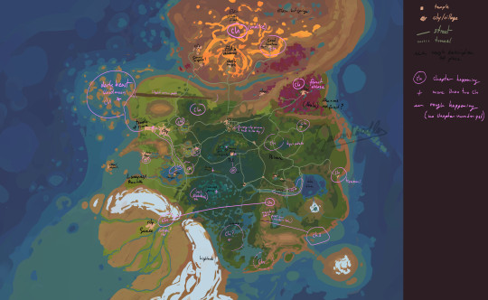
this ones with some super rough chapter markers and some descriptions, the circle doesnt mean the chapter doesnt go to multiple places but the main happening of it is there, its again, pretty rough and lacks the correct order yet too, ill prob add that with time as i write out the scripts for the next chapters, so far i got the order until chapter 6 (chapter 4 is mostly at hylias temple and since there are alot of chapters happening there its not marked seperately)
chapter 1: demon (complete)
chapter 2: a dance of ice and fire (script done)
chapter 3: moving mountains (name not final)
chapter 4: starry night
chapter 5: a wound for a wound (placeholder name)
chapter 6: curiosity (possibly placeholder name, forgot to mark it on the map even tho i know where it goes)
most other chapters i know where and whats happening but i cant remember the exact order, i gotta make a structured chapter chart soon so i dont have to think over everything every single time i need the order
this is probably not very interesting but, even tho it is just a rough layout more for myself than anything else, i thought id share anyway, i know my handwriting when i write fast and tired is hard to read but uh .. feel free to send me an ask about it if theres anything youd like to know (do mention if you are ok with spoilers for the story)
#ganondoodles#zelda#art#tloz#skyward sword#wip#making maps is hard#in general i pulled the map of skysw apart since its not evne really connected on its own map#and put some botw refs into places that arent too far from where they are in botw but also so they make more sense for skysw#also lanayru is not a desert yet tho that process has started due to hylia building what she is supposed to#... in my hc the mining of time stones takes the life out of the land since those stones are made from concentrated spirits-#-that slowly give out their energy and its all a delicate balance#which is destroyed by hylia+ mining them en masse to create the portals#that hc is also based on my hc that luminous stones eventually turn into timeshift stones bc spirits of the dead and all#anyway#yes there are actual cities and towns in skysw#its before the game anyway but like#the handful of people in the sky are not enough for me lol#and gerudo already existed too#maybe bado(groose) is like a half gerudo and thats why hes got red hair
200 notes
·
View notes
Photo

How land is used in the US. (Not regions but displayed this way to get an idea of how big they are)
1K notes
·
View notes
Text

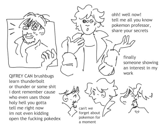
shirahama-sensei reminded me she has a thing for the teacher from pokemon s/v so i randomly went off on an au where qifrey is the professor. etc
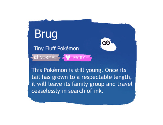
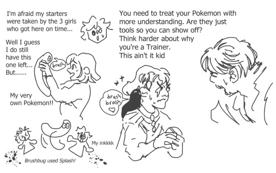
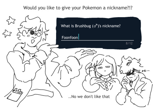
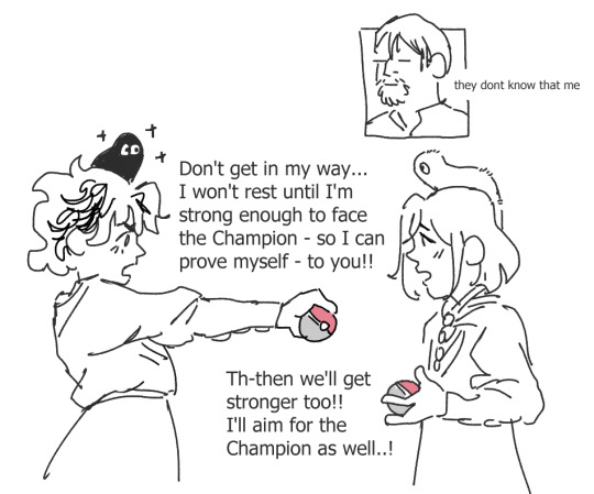
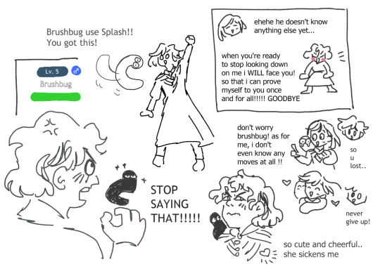
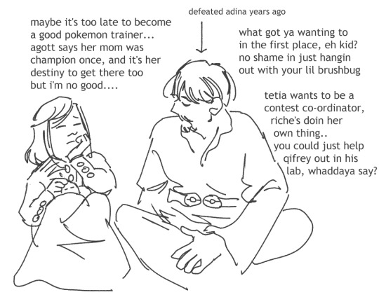
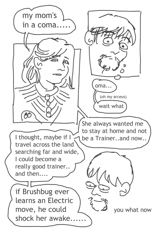
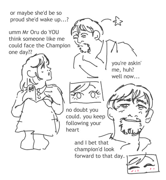
#witch hat tag#orufrey#the first image is qifrey dressed as that guy. i'm glad she has an inexplicable attachment to some dorky pokemon man like i do#someone was like 'wouldn't it make more sense for deanreldea to be the champion' .... well no. not in my world .#it maps onto magic skill. champions aren't like the Rulers of the land they're just the most skilled at this thing#oru as a burnt out champion who's gently encouraging a kid like coco to reach him one day means a lot to me. i like pokemon narratives#agott went shiny hunting for the same thing coco had but cooler - just to impress her. she really is a pokemon rival type girl#pushing myself to the limit to prove my worth to you - to get to the summit first so i'm waiting for you..#and then realising it wasn't just to be strong - i realised i started wanting to see your smile. i wanted you to have fun.#i think coco would defeat agott at the end of victory road and then defeat oru & i'll probably draw one last thing abt that at least..#the image is very cinematic..the dialogue and music in my mind..I WANT TO FACE ORU!!!!!!!!!!#the super cool insanely powerful awesome champion is the spouse of my professor and he gave me advice at the beginning...no way....#btw the elite four would be the sages which is perfect (and maybe easthies as the first guy?) evil Team Brimhats#coustas as their renegade gladion-type figure. the gym leaders would be like sun/moon and s/v combined#travelling around facing the best students from different classes - so jujy and eunie etc.#i've barely thought about 'teams' or anything bc i care amore about the narrative side of things always lol#but idk. tetia with a swirlix - eunie would be ghost type boy - riche with small things but also a ceruledge or a steelix something massiv#and brushbug would have a final form which is really long like an eastern dragon- fluffy and with wings like a fairy. It's beautiful to me#well anyway *tries to move on to the rest of life now the brief obsession has passed*#obviously oru would be fire-type tho and qifrey would be water-type and they set off together and traded their starters etc.....it goes on
145 notes
·
View notes
Text
Notes on the World Map: Melini
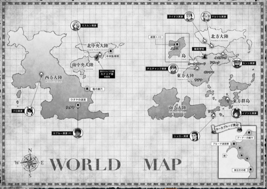
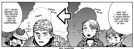
I'm kind of annoyed the complete World Bible doesn't have a version of the World Map with Melini filled in... unless it does and I missed it, but I literally bought it and looked at the relevant pages for this post! Anyway, I think this is the closest we have. I'm looking at this and -- Kahka Brud literally doesn't have a coast anymore. No wonder they're pissed!! Any industry involving the sea, trade, fishing, etc. is basically impossible now - you'd have to get to the coastline on the west side of the continent. That's probably miles!
Speaking of miles... how big is Melini?
This is where I got... really unwell. So first off, let's assume the official Dunmeshi World Map is a Mercator projection. I think the stage cartography in the Dunmeshi universe is at, it's going to be most important that maps are useful for marine navigation. So we can't just drop an approximate scale onto the grid and leave it at that; we have to work out where the equator is.
The way I've done that is via two places that seem like they have a close(ish) real world equivalent - in terms of climate and culture - Utaya and the Island of Wa (Toshiro's home). The Island of Wa is obviously Japan, and I've seen plausible arguments that Utaya is probably a climate/location similar to Nepal.
So, here's the (approximate) location and latitude of those places on a Mercator map of Earth:
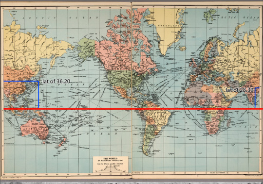
If we arbitarily superimpose the two maps, asssuming they're the same size, we can draw a theoretical equator line that puts the two places at the same latitude, though on a different side of the equator. Putting them on the same side as Earth made the equator really low. I feel like that's ... unlikely, so we're going with this.

That puts Melini at a rough latitude of .. ~55? which would, using the same scale as the previous map, make two squares (at that latitude) about 600 miles. Very roughly calculating the size as given on the map based on that, that gives a width of (approximately) 250 miles and a length of 400, coming in at a bit less than 100,000 miles² due to the shape. Probably it's between the sizes of the UK and Aotearoa.
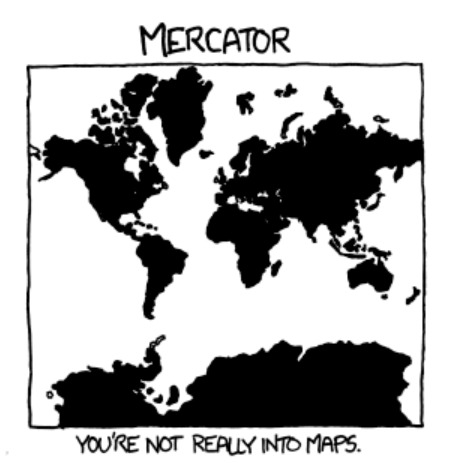
That really helps me visualise what Laios is working with here when I think about post-canon. Though I reckon what I've done here is "Just enough research to really annoy an expert". Sorry if you're that expert. I really don't know much about cartography <3 It's like that xkcd comic:
On distances, as someone who lives in the UK; with a car, you can get almost anywhere in a day if you're prepared to drive until late. But they don't have cars, so getting from one end to the other would take multiple days of travel. It'd take about 7 days to walk the approx "length", 400~ miles (from the top of Scotland to Liverpool) (according to Google Maps) and 2 days cycling, so probably 3-5 days with horses, depending on how you pushed them. That'd vary a bit depending on terrain, of course.
#og post#dungeon meshi#dunmeshi#world map notes#dungeon meshi meta#melini#if anyone DOES have the knowledge to work this out better than i have#please do! please tell me the answer!#but i just couldn't rest until i had an approximate area to work with#when i'm imagining the characters dealing with administration of remote territory#populating and partioning out land; crop failures and ensuring central storage of grain and other staples; collecting taxes and so on#kahka brud is literally a port. this is such a diplomatic nightmare. lmao. not even getting started on the monsters!#good luck with that kabru honey#dungeon meshi manga spoilers#dunmeshi spoilers
77 notes
·
View notes
Text
can we please talk more about the existence of the cheese monger’s castle

#from the lands that are map#i want to know more about the cheese monger..#starkid#cinderella's castle#the lands that are#=^_^=
41 notes
·
View notes
Text

a progress photo of a patch i’m working on. i plan for the ribbon to be yellow
inspired by a line in the prayer for peace that my shul reads every shabbat service
#in case this goes anywhere other than my little circle:#op wants a two state solution and believes that both israelis and palestinians have a right to the land#op also believes in jewish self determination#op wants the war to end and for all the hostages to be returned home#op doesn’t want either israel or palestine to be wiped off the map#op hates both governments and thinks and they both need to be tried for their crimes#jewish convert#jew by choice#diy patch#diy patches
38 notes
·
View notes
Text
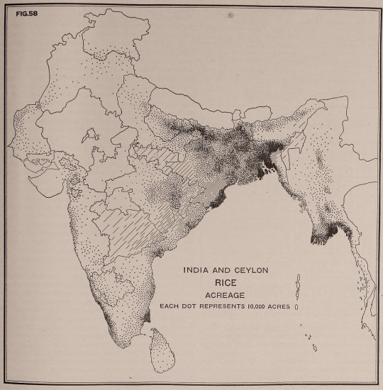
Fig. 58. India and Ceylon rice acreage. Each dot represents 10,000 acres. Geography of the world's agriculture. 1917.
#maps#charts#diagram#india#sir lanka#agriculture#each dot#dots#rice cultivation#land use#nemfrog#1917#1910s
109 notes
·
View notes
Last Seen Blogs

jesusinmychrist-blog
Devin

ticklingishappy
Untitled

pinkrymazian
strange&unusual

gingerdiva113
Deliciously Diva

jessikon9
Untitled