#transitmap
Explore tagged Tumblr posts
Visit Tumblr Blog
Explore Tumblr blogs with no restrictions, modern design and the best experience.
Last Seen Tumblr Blogs


Fun Fact
The “We are the 99%” Tumblr blog became the slogan for the Occupy Wall Street movement.
Text

Diagrama del Sistema de Transporte Colectivo "Metro" de la Ciudad de México del año 1970, con los iconos originales de cada estación que tuvo un rediseño antes de dar con los definitivos.
#public transportation#transitdiagram#transitmap#transportation#map#city#graphic design#mexico city#mapa#transporte público#logo design
7 notes
·
View notes
Photo

The Future of Metro Manila Rail Transit Map in 2035 🚄LRT 1 + Cavite Extension (Redemptorist - Niog) + North Triangle Station (Unified Station) 🚅LRT 2 + Proposed West Extension (Tutuban - Pier 4) 🚃MRT 3 + North Triangle Station (Unified Station) 🚈MRT 4 (EDSA - Taytay) 🚞The Subway of Makati, MRT 5/Makati Subway (Mile Long - Sampaguita) 🛤️LRT6, The Quadrant Route(6A - 6D) 🚅Suburban Express, Mrt7 (North Ave. - SJDM) 🚄The University Line, Mrt8 (University Ave. - Higaldo ) 🚈Metropolitan Chord, Mrt9/Metro Manila Subway (East Valenzuela-Bicutan+NAIA Ext.) 🚃The NSCR Voyager (New Clark City to Calamba)
#metromanilatransit#masstransportation#transportdesign#mrtphilippines#urbanplanning#metromanila#metromanilamrt#subway#manilasubwayproject#transitmap#metropolis#infrastructure#infra#infrastructuredevelopment#futureofmobility#metromanilasubway#filipino#travel#cityconnection
0 notes
Photo

#netzspinne #transitmap #highspeed #train #drips #dirt #spurloser #spaceshuttle #urbandermatology https://www.instagram.com/p/Co5vHgsoqyo/?igshid=NGJjMDIxMWI=
8 notes
·
View notes
Photo

Black Friday Cyber Monday deal. 15% off everything at https://www.vanmaps.com
3 notes
·
View notes
Photo

#MapMondays – The future subway system without federal funding. This map illustrates the devastating reality of public transit in New York City if the MTA is unable to secure $12 billion in federal relief by the end of the year, reducing subway and bus service by 40% and commuter rail by 50%. The map was created by Riders Alliance, who compared the 2010 service cuts (removal of the V and W trains with 110 bus routes shortened or cut) to the current budget shortfall, concluding the MTA would have to cut all service on the 1, 2, 3, 7, B, D, F, M, G, J, and Z lines and the Franklin Avenue S. Last week the MTA presented a budget proposal that would nearly cut the service in half and lay off over 9,000 transit workers. The Long Island Railroad and Metro North would also see major cuts. #mapmonday #subway #publictransit #mta #nycsubway #transit #railfan #midtown #nyhistory #nyctransit #nytransit #lirr #metronorth #grandcentral #transitmap #brooklyn #thebronx #queensny #skyline #mtanyc #urbanism #transportationplanning #urbanplanning #manhattan (at MTA Subway - 42nd St/Times Square/Port Authority Bus Terminal) https://www.instagram.com/p/CH8og_qHI4g/?igshid=ftdanflwfgim
#mapmondays#mapmonday#subway#publictransit#mta#nycsubway#transit#railfan#midtown#nyhistory#nyctransit#nytransit#lirr#metronorth#grandcentral#transitmap#brooklyn#thebronx#queensny#skyline#mtanyc#urbanism#transportationplanning#urbanplanning#manhattan
16 notes
·
View notes
Photo

Finally working back on this Westeros Map to make it clearer and more readable !
#got#got7#asoiaf#westeros#stark#Lannister#map#transit map#transitmap#fantasy#book#geek#subway#railway#metro
5 notes
·
View notes
Photo

Do you need to get around #nyc in the 1960s? We have a map.... #clittleshop #newyorkcity #trainmap #readingrailway #readingrailroad #vintage #ephemera #transitmap #manhattan (at CLittleShop) https://www.instagram.com/p/COz8Td1lFFI/?igshid=w2v2wu9sntvx
#nyc#clittleshop#newyorkcity#trainmap#readingrailway#readingrailroad#vintage#ephemera#transitmap#manhattan
0 notes
Photo

This map I made is from Mini Metro, a mobile game based off of metro/subway systems I find really fun to play. I love looking at metro maps. The lines, colours, and the places featured really entice me, and the fact that trains run on these lines makes me picture myself riding along the system. These maps appear to be designed in the London Underground style, one of my favourite metro systems (and also the oldest in the world!). A colourful game like this would keep train, map and metro junkies entertained for hours. #game #mobile #mobilegame #metro #map #metromap #transit #publictransport #entertainment #gaming #mini #minimetro #subway #subways #transitmap #fun #videogames #shapes #lines #instadaily #londonunderground #londontube #underground
#publictransport#transitmap#map#videogames#fun#game#shapes#metromap#gaming#mini#minimetro#instadaily#londonunderground#subways#londontube#subway#underground#lines#metro#transit#mobile#entertainment#mobilegame
1 note
·
View note
Photo

Admaps print shop - opening soon! #transitmap #map #melbourne
3 notes
·
View notes
Photo

Et voilà, toutes les stations du métro de Paris sont sur Citylines.co. Il n’y a plus qu’à tracer les lignes maintenant !
Citylines est un projet de cartographie libre et collaborative des transports en commun du monde entier, permettant de voir les lignes évoluer à travers les années.
1 note
·
View note
Text

A partir del Mapa que hice para representar los diferentes servicios de la Línea 4 del Metrobús y por ser un usuario casi diario de esta, llevé a cabo una idea que tengo desde hace mucho tiempo:
- Línea 4 tiene que volver a ser una línea que solo comunique San Lázaro con Buenavista pasando por el Centro Histórico.
- Por el servicio del Suburbano al AIFA, se debe de regresar la ruta Buenavista - Terminal 1 y Terminal 2 para crear un buen puente entre ambos Aeropuertos.
- Las rutas Hidalgo - Pantitlán - Alameda Oriente se DEBEN de volver una línea independiente, que vaya por el Eje 1 Norte hasta Buenavista, aprovechando que COPATTSA tiene la concesión y desahogando Ruta Norte, la cual esta colapsando cada día un poco mas.
- Con la eliminación de las rutas de Hidalgo, Ruta Norte queda mas libre, permitiendo un servicio, que la ruta al Aeropuerto pueda pasar por ahi sin problemas y elimina la necesidad de crear la ruta República de Argentina - Museo de la Ciudad, por estar menos congestionado y permitir una mejor afluencia de los Metrobuses
(Todo esto sin contar lo obvio, se necesita mejorar todo el corredor de MB4 para que mejore aun mas la experiencia de los Usuarios y operadores)
#public transportation#transitdiagram#transitmap#transportation#mapa#map#transporte público#city#graphic design#mexico city
3 notes
·
View notes
Photo

Barcelona — all three tram networks in a single map [transitmap] [unofficial] [OC]
6 notes
·
View notes
Photo
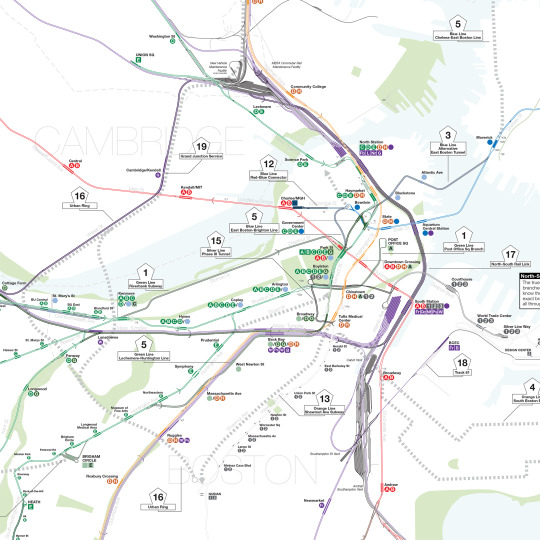
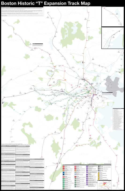
The Boston Historic "T" Expansion Track Map shows every proposed extension of the T since 1897.
https://www.vanshnookenraggen.com/_index/2021/03/boston-historic-t-track-map/
15 notes
·
View notes
Photo

#MapMondays - “The Arterial System” 1964, showing completed, under construction, in planning, and future highways. The proposed projects on this map that were never constructed include LoMex (Lower Manhattan Expressway), the Mid-Manhattan Expressway, the Bushwick Expressway, Interborough Parkway (Brooklyn), Prospect Expressway extension via Ocean Parkway, Sheridan extension, and the Shore Front Parkway on the Rockaway Peninsula. Many of these proposed routes were projects of Master Planner and Triborough Bridge & Tunnel Authority Chairman Robert Moses, who was pushed out of power four years later when the TBTA was merged into the Metropolitan Transit Authority and toll funds were diverted to save the city's ailing agencies including the subway. 🚗 Tap to purchase a copy of the map 🚙 #mapmonday #cartography #transitmap #nyc #brooklyn #rockaway #bushwick #oceanparkway #sheridanexpressway #robertmoses #powerbroker #shorefrontparkway #prospectparkway #brooklynqueensexpressway #brucknerexpressway #lomex #expressway #queens #bronx #urbanism (at Bushwick, Brooklyn) https://www.instagram.com/p/B-Fn0DMHy_G/?igshid=12xe9ctgabiwk
#mapmondays#mapmonday#cartography#transitmap#nyc#brooklyn#rockaway#bushwick#oceanparkway#sheridanexpressway#robertmoses#powerbroker#shorefrontparkway#prospectparkway#brooklynqueensexpressway#brucknerexpressway#lomex#expressway#queens#bronx#urbanism
26 notes
·
View notes
Note
this isn’t a question but i really love this account! i’m a big fan of transit maps so thank you a lot! :)
Oh wow, thank you so much! I’m so glad you like my maps.
If you aren’t already, I’d recommend following @transitmaps if you’re a fan of these sorts of things—I generally just post the maps I personally make, while Cameron posts a ton of maps made by different people from all around the world. I’d also recommend the books Transit Maps of the World and the lesser-known Railway Maps of the World, both by Mark Ovenden—there’s a ton of cool stuff in there.
And if you’re interested in making transit maps yourself, I’m happy to give pointers! My personal methods are somewhat unconventional (since I’ve never really used Adobe products), but I’ve learned a number of tips and tricks that I’d be happy to share! (Cameron at @transitmaps has even better tips, though; he’s posted a number over several years.)
Anyway, don’t hesitate to reach out to me if you want to talk about maps (or anything, really) or if you have any requests for maps you’d like me to make! Thanks for your message, and I’m gonna keep the posts coming! :D
3 notes
·
View notes
Photo

And finally Northrend, clearly inspired by Washington Metro
#world of warcraft#warcraft art#metro#underground#subway#map#design#transit#transitmap#washington#northrend#Arthas#geek#video games
4 notes
·
View notes