
Statistics
We looked inside some of the posts by thecacoast and here's what we found interesting.
Average Info
Notes Per Post
45
Likes Per Post
39
Reblog Per Post
6
Reply Per Post
0
Time Between Posts
22 days
Number of Posts By Type
Text
16
Photo
1
Last Seen Tumblr Blogs


Fun Fact
Tumblr Inc. is funded by 13 investors.
Text
Be a Naturalist
Head out to the shoreline between June 1st and June 16th to participate in California Academy of Sciences' annual Snapshot Cal Coast event.
Sounds great! Let’s do it. Pigeon Point Light Station State Historic Park here we come!
Off of Highway One in Pescadero, on Pigeon Point Road, there are Pigeon Point Bluffs which sit just above a wonderful place to go tidepooling. As you wind further down that road there is Pigeon Point Lighthouse & Hostel where we stayed overnight to wake up early June 2nd to find sea anemones, sea stars, crabs, and maybe even nudibranchs or an octopus amongst the rocky outcrop.

heading to the furthest section of jutting out rocks

sweet spot for tide pooling

Anemone

A bat star

wrapping up for now but there is plenty we didn’t see that is likely scurrying around or hiding under rocks

It was a cold morning but full of interesting and beautiful things, and it is fun to be a naturalist (with the help of an app and the encouragement of a statewide event to get you motivated). What will you see?
https://www.calacademy.org/calcoast
Join us in this effort to discover, record, and share observations of plants, seaweeds, and animals found along the California coast, no prior experience necessary! Use the iNaturalist app to record your observations, which makes it easy to upload your photos and get expert help in identifying what you've found. This is a fun reason to visit the coast on your own, with your friends, or with your kids, while contributing to an important collection used by scientists to better understand this special ecosystem.Learn more on the Snapshot Cal Coast webpage. Check YourCoast.org (or download the YourCoast app for iPhone) to find the perfect coastal spot to make your observations.

#pigeonpoint#lighthouse#calcoast#tidepool#seastar#anemone#tidepooling#coastal#california#citizenscien#naturalist
4 notes
·
View notes
Text
Yes. Plastic Pollution Prevention Really DOES Matter!
By Eben Schwartz, Marine Debris Program Manager

At the end of March, I was invited to London to speak at The Economist Magazine’s annual Sustainability Summit to talk about plastic pollution. I admit I was a bit overwhelmed by the invitation – a leading international business and public affairs magazine is a larger stage than I’m used to! But plastic pollution has been a topic of growing interest for several years now, and California has been one of the progressive leaders on this issue (as it is on so many issues). I have been working on actions and policy development around this issue since 2000, so I felt qualified to attend and discuss our growing understanding of the challenges presented by plastic pollution.
The title of the panel was “Hard Talk Part 1: Do Plastics Really Matter?” The idea, I gathered, was to try to pit me and my understanding of the threats of plastic pollution against others representing the “carbon-side.” In other words, can we afford to worry about plastic pollution in the face of impending catastrophic climate change? This seemed, from the start, to be a somewhat silly question – of course we need to address both! Thankfully, as it turned out, my fellow panelists agreed with me. Joining me for the discussion were Tom DeLay, CEO of Carbon Trust, and Philip Lymbery, CEO of Compassion in World Farming. Catherine Brahic, the chief science correspondent for The Economist, moderated our all-too-short discussion. From the start it was clear that there was widespread agreement on the panel that plastic pollution is an issue that we need to address, no matter what other threats may exist. It’s an issue of vital concern. Add in the projection that the plastic industry is set to increase production by 40 percent over the next decade, by which point plastic production will account for 20 percent of global fossil fuel consumption (coal, oil, and natural gas), and all of a sudden addressing plastic pollution becomes a means to address climate change as well.

Not that there weren’t disagreements. Mr. DeLay of the Carbon Trust indicated that companies need to make environmental decisions based on industry-sponsored life cycle analyses of products and materials. I pointed out that none of those life cycle analyses account for the end-of-life of those products or materials, and therefore they don’t provide a true picture of the overall impacts (I’ve never seen an LCA that accounts for a plastic bag ending up in a sea turtle’s stomach, for example – but we know for a fact that is where a number of them end up). Mr. Lymbery pointed out that healthy oceans are ones where overfishing does not occur. But healthy oceans are also places where plastic does not pollute the food web with toxic chemicals that can bioaccumulate. Despite these minor differences, however, we were largely in agreement, and overall, it was inspiring to hear that, even from the “carbon-side” of the environmental threats equation, plastic pollution is an issue that is rising to the top. In addition, I was able to call attention to major steps California has taken towards regulating single-use plastic bags, plastic straws, and trash in our stormwater systems – all while regulating auto tailpipe emissions and carbon through a cap-and-trade system. Proof, as I mentioned at the summit, that we can walk and chew gum at the same time.
#climatechange#marinedebris#experts#theeconomist#london#california#climate#plastic#industry#solutions#education#prevention#oceans#health#cap and trade#carbon#pollution
4 notes
·
View notes
Text
Sea Level Rise Presents Challenges for Coastal Communities; King Tides Show us those Challenges
The year's highest tides, known as “king tides,” will hit California shorelines December 22 & 23and again January 20 & 21, providing a glimpse of what we expect as sea levels continue to rise.
Visit california.kingtides.net for a calendar of community King Tides events, a map of king tide times, resources for educators teaching about sea level rise, and to learn how to submit your king tides photos to the project.
Engage on social media: facebook: cakingtides ● twitter: CA_king_tides ● instagram: ca_king_tides #kingtides

The public can contribute to the California King Tides Project, an important citizen science initiative to help California communities prepare for an uncertain future, by first visiting california.kingtides.net. The project asks Californians to observe the ultra-high tides and share their photographs in order to illustrate how homes, harbors, beaches, wetlands, seawalls, and public access to the coast are affected and will continue to be affected by sea level rise.
“To see the change that happens with a single foot of sea level rise along the California coast, you can visit a site one week before or after a King Tide event, observe the water level, and then compare that to the same site during a King Tide. The King Tide levels will show our future normal high tides after sea level rise.” – Lesley Ewing, Senior Coastal Engineer, California Coastal Commission
The images shared by the public are used by State and local officials as well as climate change researchers to validate sea level rise models and better assess local flood vulnerabilities. Understanding the impacts of sea level rise is essential to finding the best way forward that balances all communities’ interests.

According to the California Ocean Protection Council’s updated Sea Level Rise Guidance, the seas are rising more, and faster, than previously anticipated, with significant consequences for the State. While the height and rate of sea level rise will vary along the coast of California, San Francisco for example is projected to see a rise in sea level between 1.1 and 2.7 feet by 2050. By 2100, San Francisco could experience between 2.4 and 6.9 feet of sea level rise, depending on how strongly we curtail our use of fossil fuels, with a potential for more than 10 feet of rise if there is extreme melting of the West Antarctic ice sheet.
“King tides provide a snapshot view of the impacts of sea level rise we can anticipate in the coming decades. Sea level rise is real; it is happening now and will continue to threaten homes, critical infrastructure, public health, the environment and access to the coast. We must prepare for the consequences – lives, livelihoods, the coastal economy, coastal habitat and wildlife are in the balance.” – Deborah Halberstadt, Executive Director, California Ocean Protection Council

California is working to fight climate change and reduce future sea level rise. The State of California recently passed the 100 Percent Clean Energy Act which calls for 100 percent of total retail sales of electricity in California to come from eligible renewable energy and zero-carbon resources before 2046.

Review the California Coastal Commission’s draft Residential Sea Level Rise Adaptation Policy Guidance at www.coastal.ca.gov/climate/slr/vulnerability-adaptation/residential.
Read the 2018 update of the California Ocean Protection Council’s State of California Sea-Level Rise Guidance.
#sealevelrise#climatechange#california#californiacoast#water#observe#citizenscience#citizenscientist#holiday#kingtide#winter
4 notes
·
View notes
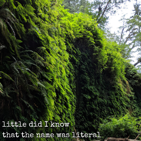
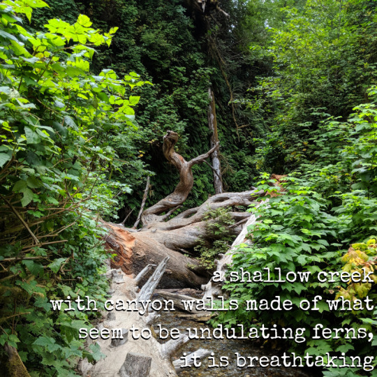
Text
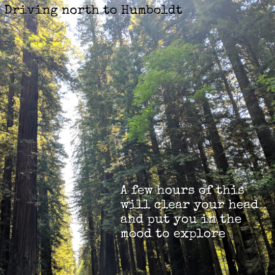
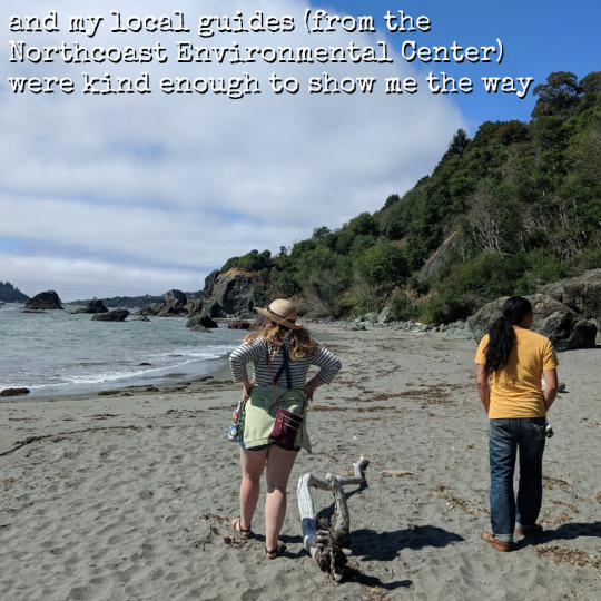
Coordination Often Benefits from an In-Person Visit to Humboldt County!
- Photos and text by Leah L. Henry
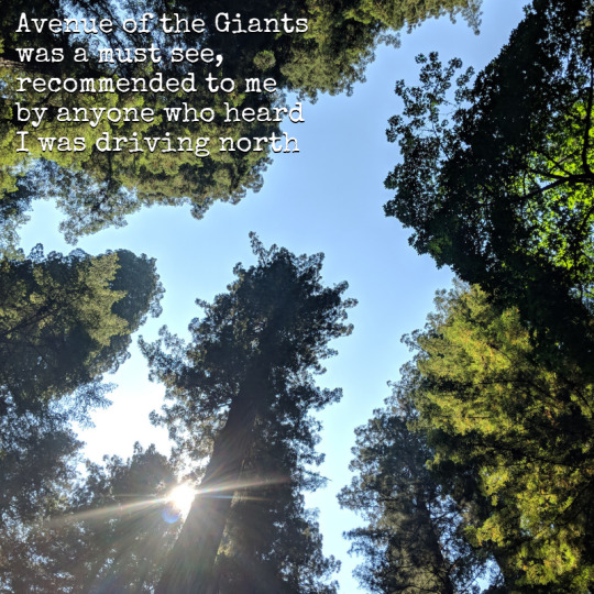
In preparation for the 34th Annual California Coastal Cleanup Day, I had the distinct pleasure of traveling up the coast to visit our Humboldt County Coordinator, Madison Peters, from the Northcoast Environmental Center.
The trip featured enormous redwood trees, lush ferns, pristine beaches, hidden coves, charming towns, farmers’ markets and coops, and warm and kind people. There is much more to see in this area of California than featured here, I highly recommend discovering it yourself. Use a California Coastal Access Guide so you don’t miss a thing.
The land known as Humboldt is the ancestral home of Wiyot, Yurok, Hupa, Karuk, Chilula, Whilkut, and the Eel River Athapaskan peoples (Wailaki, Mattole and Nongatl)
Avenue of the Giants


Humboldt Lagoons State Park

Luffenholtz State Beach

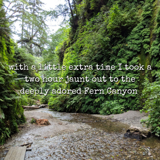
Fern Canyon in Prairie Creek Redwood State Park

Thank you!
2 notes
·
View notes
Text
Inspired by Our Coast & Ocean? Enter the Art & Poetry Contest!
California students in kindergarten through 12th grade are invited to submit artwork or poetry with a California coastal or marine theme to the annual Coastal Art & Poetry Contest. You can win great prizes and have your work featured online and exhibited throughout California!

Up to ten winners will be selected to win $100 gift certificates to Blick Art Materials (for artists) or a book store of their choice (for poets). Each winner's sponsoring teacher will receive a $50 gift certificate to Acorn Naturalists. All winners, their teacher, and honorable mentions will receive tickets to visit Aquarium of the Pacific and Seymour Marine Discovery Center.

View the 2018 Coastal Art & Poetry Contest online and at the remaining exhibit venues:
Channel Islands National Park Visitor Center, Ventura Harbor, now until mid-November
Seymour Marine Discovery Center, Santa Cruz, December 2018 and January 2019
Entries must be postmarked by January 31, 2019 to be eligible for the upcoming contest. For rules and entry form (and helpful links for teachers and students), visit our website or email [email protected]. You can also download a contest flyer (available in English and Spanish).

Listen to a recording of “The Great White” a poem from Elin Ekenheim, the youngest winning poet of our 2015 Coastal Art & Poetry Contest.
Prints of past winning art as well as winners from our photography contest are available for purchase, helping to fund this contest.
Prizes and support provided in part by: Acorn Naturalist, Aquarium of the Pacific, Seymour Marine Discovery Center, Blick Art Materials and Tabula Poetica.

We are looking forward to your entries!
#art#poetry#coastal#coast#ocean#inspire#prizes#blickartmaterials#acornnaturalist#aquarium#marine#marinescience
3 notes
·
View notes
Text
An afternoon at William R. Hearst Memorial Beach, north of Cambria, San Luis Obispo
By Linda Locklin
To celebrate the re-opening of Highway One through the Big Sur coast, I took a trip to the Central Coast to enjoy some nice post-summer weather, meaning hopefully there would be sun and little fog. I was rewarded with beautiful blue skies and lots of gorgeous coastline views.
After walking along the working waterfront promenade in Morro Bay, I headed north to William R. Hearst Memorial Beach. The lovely sandy cove is often overlooked by the main tourist attraction of this area, which is Hearst Castle. The Castle sits high above the hill while the beach below is flanked by a pier and the tree lined San Simeon Point. The Coastal Discovery Center is also located just off the beach parking lot.

[William R. Hearst Memorial Beach]
The pier provides a great opportunity to fish, view birds, check out the thick kelp beds and look for sea otters.


[View across bay north to San Simeon Point]
This state beach is surrounded by the Monterey Bay National Marine Sanctuary, which covers 226 miles of shoreline from Cambria to Monterey. Check out the interpretive panels which line the pier.


#otters#sansimeon#fish#piers#marinemammals#local#birds#wildlife#nationalmarinesanctuary#sansimeonbay#bays#montereybay#coastal#coastalaccess#hearst
0 notes
Text
Honorable Mention: See Serenity’s Art on Exhibit!
Six year old Serenity Rayne Holmes entered last year’s California Coastal Art & Poetry Contest with a whale-inspired watercolor and won honorable mention.
Her artwork will be on display at the Channel Islands National Park visitor center in Ventura alongside more than 40 winning pieces through Nov. 18th.

Below is Serenity’s painting titled “Father”.
Read an article about Serenity and her artwork: https://www.vcstar.com/story/news/special-reports/outdoors/2018/09/18/ventura-6-year-old-winner-picture-channel-islands-park-whale-watercolor-father-coastal-commission/1297128002/

#art#poetry#coastal#poems#ocean#california#nationalparks#parksforall#ventura#talent#contest#prizes#enter#win#honorable#whales#serenity
3 notes
·
View notes
Text
Piece By Piece: A look at how the Coastal Commission has helped increase public access and keep the California Coastal Trail growing
--By Sylvie Lee
On the day before the Coastal Commission began their public meeting in Fort Bragg, Mendocino County, five staff members—from the chief deputy director on down to a humble program coordinator (yours truly)—shared an all-day van ride to get there, exploring along the way some wonderful areas with gorgeous ocean views that the Coastal Commission has helped open up to the public.

The first people in the group began in Santa Cruz at 7 am and picked up the rest of us as they traveled, and by 9:15 everyone was in the van and heading north. Our first stop was to pick up food in Sebastopol, Sonoma County, but the consensus was that it would be even better to get a jump-start on lunch instead of just taking our sandwiches for later.

Our first sight-seeing stop was unexpected. We were just talking about how we thought the Wildlands Conservancy’s new open space in Jenner was still closed to the public, when imagine our surprise and delight to discover it’s now open.

Imagine our further surprise and delight to discover that one of the signs at this spot includes a quote by the late Peter Douglas, former executive director of the Coastal Commission and former boss to all of us.

Jenner Headlands Preserve is in Sonoma County just a bit north of the Russian River. We didn’t have time to hike up the hill and do it justice but we all want to come back because the spot is absolutely beautiful.

This trip was planned by Linda Locklin, the Coastal Commission’s Public Access Manager. She’s been with the agency for decades, she’s a human encyclopedia of public access points along the California coast, and she wanted to share some of the Commission’s more recent successes in opening up parts of the California coast for public enjoyment. To start us off, she took us to the Gualala Bluff Trail.

This half-mile path runs along the cliff behind local businesses and was created by joining together three different segments that became open to the public through easements from three different property owners. The public easements were provided in conjunction with development permits they received from the Coastal Commission. After the public access easements were all acquired, there were lawsuits and other complications, and an organization also had to step forward to build, maintain, and operate the trail, and that organization is the Redwood Coast Land Conservancy. “It was a great victory, but it took decades!” Linda declared. She explained how there’s no sidewalk in Gualala to let people walk and enjoy the ocean view, so this trail really fills a gap. We walked from end to end, enjoying looking down at the mouth of the Gualala River.


The next stop was at a lovely sandy cove called Cooks Beach. Reached from County Road 526 off Highway 1 north of Gualala, it’s a bit hidden away and a wonderful beach whose public enjoyment is made possible by access easements from the Bonham Family, provided (like the last spot) through Coastal Commission requirements stemming from their coastal development permits. Funding for the trail here (also like the last spot) was provided by the State Coastal Conservancy.


For our next visit, we were lucky enough to have guides. Still traveling north in Mendocino County almost to Point Arena, we went to the second-newest California coastal access point (now that the preserve in Jenner is the newest), called Pelican Bluffs Preserve. We were met by Ann Cole and Nikki Houtz (and Bandito, the official dog on staff) of the Mendocino Land Trust, and they took us on a great hike through this preserve and along the California Coastal Trail (part of which, again, is from public easement requirements from the Coastal Commission). The scenery was truly incredible. You can watch this video to learn more about the story of Pelican Bluffs.


The California Coastal Trail will one day go all along the western edge of California from Mexico to Oregon. It’s a long-term project to put it together, piece by piece, with pathways that may not exist yet, on land belonging to many different property owners. Currently it is over halfway completed. The segments we visited today that are part of the Coastal Trail are helping bring a finished route that much closer to reality, little bit by little bit.

Our last coastal hike of the day was at Navarro Point Preserve. Ann and Nikki led us to a special spot, a memorial for a well-liked Coastal Commission legal assistant named Deborah Bové who passed away unexpectedly in 2001. We paid our respects at a bench created in her honor by a local artist commissioned through donations from her old colleagues. The artist built it out of driftwood and made it extra-long to fit the many members of Deborah’s large family.


Still continuing north, by the end of the afternoon we were getting a little bit punchy. Linda had been praising the effectiveness of Offers to Dedicate (OTDs), which are the public access easements the Coastal Commission obtained to make these different trails possible. “Give me an ‘O’!” she called out. “Rah rah ree, OTD!” Tami sang later.
Once we arrived in Fort Bragg and our “work” day was finished (12 hours after the folks in Santa Cruz started), we met up with some of our co-workers to eat dinner. But I had to step out as the sun was going down to capture that too.


Early the next morning, in pursuit of more adventure (and blog content!), I enjoyed a fabulous sunrise walk at Pudding Creek Beach and the trestle bridge there. The bridge is part of the Haul Road, also part of the California Coastal Trail, and it had been closed for 25 years before it reopened and was able to reconnect the different sections of Fort Bragg that had been separated without a walkway. (You can watch a video on the Haul Road to learn more about this portion of the California Coastal Trail.)


And then it was off to the Coastal Commission meeting, the reason we had come to Fort Bragg. But when we were done, I couldn’t resist one more stop at the brand new space for the Noyo Center for Marine Science, and walked through the front door just as the people there were literally hauling the bones of a killer whale up toward the ceiling for display. This is the largest orca specimen held in a collection, and it will eventually be part of a whole interpretive exhibit supported in part by a Whale Tail grant from the Coastal Commission. The skeleton was assembled through a big community effort, and you can watch a video about that great story here.


The orca is being put together piece by piece too.

#mendocino#california#californiacoast#californiacoastaltrail#californiacoastalcommission#exploreyourcoast#fortbragg#coastalaccess
1 note
·
View note
Text
Matt Beard Painting His Way Along the Coast Donates Artwork to Help Clean it
Matt Beard is a surfer and artist living and working in Humboldt County who has a deep appreciation for the California coast. He generously donated his artwork to promote the 34th Annual California Coastal Cleanup Day. And it seems fitting that Beard would be featured front and center, connecting his long standing love and care for California once again through art and action.
For more on the initial conversation visit Lost Coast Outpost’s article: https://lostcoastoutpost.com/2018/jul/20/paintings-local-artist-matt-beard-selected-promote/
By celebrating the Cleanup with his incredible work we honor the entire state on the largest volunteer-driven event dedicated to the environment on the planet.
“I am super thankful that California has valued coastal access and preservation for so long. In contrast to places that are more developed, the California coast remains both accessible and preserved. It is a nice balance.” - Beard
Beard recalls being captivated by the diversity of the coast from an early age, and continues to channel inspiration into his current artwork. You can see the artist here capturing another coastal mile with his brush.

“Every painting has a story to tell; fences hopped, encounters with friendly locals, battles with nature itself while attempting to paint out on the edge of a cliff in the wind and against all better judgement.” - Matt Beard
Beard Maintains his long term goal of painting the entire California coast and aims to release a book this Fall.

“...it’s appropriate that by far the longest running thread in my visual explorations has been the California coast. The moods, topographies, geologies, and our interaction with it all is varied enough to inspire several lifetimes of art. I’m doing all that I can with the short time I have left.”

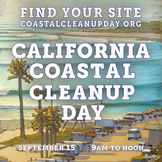
We will stay posted on what Matt Beard paints next as he is well on his way to painting the entire the California coast! And we will see you out there September 15th! Thank you for all who contribute to make this event possible, artists, donors, designers, sponsors, volunteers, organizers, friends, family, and California.
www.coastalcleanupday.org

#coastalcleanupday#coastal#ocean#protectwhatyoulove#paint#mapping#mattbeard#inland#love#waterways#Saturday#cleanups#surf#surfer#organize#action#waves#ocean waves#california#californians#care#volunteer#event#weekend
2 notes
·
View notes
Text
Trinidad California’s Beautiful Coast
-Photos and text by Destiny Preston
On a warm spring day in Trinidad, students gather to admire the waves and Pewetole Island, a tree-covered offshore rock at College Cove Beach.


Looking out from the trees toward the ocean.

Humboldt County - where the redwoods meet the rugged coastline.
Learn how to get to College Cove Beach on YourCoast.org.
4 notes
·
View notes
Photo

Moonstone Beach during the August 2018 fires in California, Oregon and Canada displayed dramatic sunsets, with Camel Rock in the distance.
Find directions and amenities for Moonstone County Park at YourCoast.org.
4 notes
·
View notes
Text

A thin layer of fog shrouds Camel Rock and laps at Trinidad Harbor. Is it coming or going?
Visit YouCoast.org for directions and amenities at Trinidad Harbor. Let us know the status of the fog when you get there.
1 note
·
View note
Text
Mendocino Headlands, Up Close
“These driftwood pieces were photographed on one of the pocket beaches below the Mendocino Headlands. I lived in Mendocino village for a short time during grad school and I loved to run loops on the headlands, but I had never actually been down to any of the beaches until last year, when I happened to find a trail on a walk. There was a lot of wood debris on the beach and I loved the variation in color and texture in the driftwood and drift sticks. The ‘big views’ in the Mendocino area are well known, but there is a lot to discover at the small scale, too.”
~Sarah Carvill, Coastal Program Analyst

Discover your special place on the California coast on YourCoast.org.
5 notes
·
View notes
Text
Mitchell’s Cove, Santa Cruz
“My dog, Juneau, is a husky mix who loves to run, and dogs are allowed off-leash on Mitchell’s Cove beach in Santa Cruz before 10 a.m. and after 4 p.m. each day. The beach is surrounded by bluffs on three sides and accessed only by a staircase, so the dogs are relatively contained—it’s like a natural dog park. When I take Juneau there, he usually gets the “zoomies” (a term dog owners will understand) and tears around in giant circles jumping over and off of large rocks and into piles of seaweed. I somehow captured this picture as he sprinted by me on a broad, smooth rock at the eastern end of the beach.”
~Sarah Carvill, Coastal Program Analyst

Find out how to get to Mitchell’s Cove Beach on YourCoast.org. This is a City of Santa Cruz beach.
1 note
·
View note
Text
Nicholson Point Park, La Jolla
“On a recent bright spring day, a diverse multitude of Californians were joyfully exercising their right to access the coast, forming a dense carpet of humans from the sibilant sandbars to the pinniped pack on the seawall. I however, was not craving crowds. I was seeking coastal solitude, quiet, a chance to reflect. Could I find a coastal quiet zone on a busy Saturday in densely populated southern California?
Turning my back to the masses, I walked south and away from the Scripps Park area, but again, I was thwarted in my quest for quiet. This time it was buildings, condos, and privacy walls that crowded the coast. Block after block I walked, enjoying the lush landscape of the coastal properties but getting irritated at my inability to access a serene shoreline. Soon however, the day was saved by a white sign with blue lettering and a funny looking wave logo upon its face, I had stumbled upon a Coastal Accessway. Navigating through the high rises kept me skeptical for the first moments, but soon I could hear waves, feel the breeze, smell shoreline wrack. Best of all, the beach was a quiet place featuring a few beach walkers, a dog playing with a child, surfers bobbing offshore.
Sometimes, a coastal accessway is more than a path to the beach. Most times, it leads into your heart.”
~ Kurt Holland, Environmental Literacy Specialist and Lecturer, Department of Science Education, CSU Long Beach


The Nicholson Point Park accessway is found at the south end of Coast Boulevard in La Jolla, between residential buildings 100 and 202 Coast Boulevard. Find a map and a description of amenities on YourCoast.org.
The California Coastal Act of 1976 directs the California Coastal Commission to “maximize public access to and along the coast and maximize public recreation opportunities in the coastal zone consistent with sound resource conservation principles and the constitutionally protected rights of private property owners.”
Remember to Look For The Feet when you want to put yours in the sand on the California coast.

0 notes
Text
Big River Beach and Trail
In mid-June we had a clear, sunny day at Big River Beach, directly south of the town of Mendocino. Families played in the fine sand and a surfer enjoyed the waves.


The beach continues on the other side of the bridge, with more families enjoying calm water and kayaks floating by.

A flat, wide trail follows the river east for 10 miles, accessible for walkers, wheelchairs, horses, and bikes, made possible by Mendocino Land Trust's 2002 purchase and transfer of 7,334 acres to State Parks.

Some of the trail is unshaded (and can be quite hot on a sunny Mendocino day), and some of it is in ferny shade.

We saw lots of wildflowers along the way. (How many of these can you name?)

Abundant thimbleberries were just beginning to ripen.

Walk as far as you like, then turn back for beautiful views of Big River as it flows out to the ocean.

1 note
·
View note
Text
Ecological Staircase Trail at Jug Handle State Reserve
Let’s go on a little trip to Jug Handle State Natural Reserve, on the California coast just off of Highway One between Mendocino and Fort Bragg.
There’s a sandy beach at Jug Handle, and up from the beach is an arching bridge. First circle around the headlands, then walk inland under the bridge. The five mile (total round trip) Ecological Staircase Trail takes us on a tour of geological updrift from the coast to a pygmy forest. This hike through five marine terraces demonstrates 500,000 years of ecological succession (100,000 years per terrace). Pick up an informative brochure if you’d like to follow the self-guided tour.

The journey up the ecological staircase begins with many steps down. You can then enjoy the dappled shade while crossing a much less assuming but equally lovely bridge.

Making your way up through forests of spruce, fir, and redwood, keep an eye out for the colors and textures of plants small and large. In the late summer you may be treated with ripe huckleberries.

At the top of the ecological staircase is a pygmy forest. The fragile soil is protected from your footsteps by a boardwalk. Pygmy cypress, redwood, rhododendron, and reindeer lichen can be seen here.

As you return back down the trail, enjoy the transition from sun to shade.

You made it! And you only had to travel 500,000 years.

6 notes
·
View notes