
Satellite Based Crop Health Monitoring, Crop Issue Identification System, Farmers' Social Network and Much More.
Don't wanna be here? Send us removal request.
Statistics
We looked inside some of the posts by farmonaut and here's what we found interesting.
Average Info
Notes Per Post
6
Likes Per Post
4
Reblog Per Post
2
Reply Per Post
0
Time Between Posts
4 days
Number of Posts By Type
Photo
15
Video
2
Last Seen Tumblr Blogs


Fun Fact
70% of Tumblr users say the Dashboard is their favorite place to spend time online.
Photo

A new article is released!! The leaves affected by cotton leafhopper jassids turn yellowish, then brownish starting from the margins and migrating to the midrib. Leaves gradually show signs of curling before drying completely and shedding. Severe incidences result in “hopper burn” injury and death of leaves, eventually leading to the stunting of young plants. The fruiting capacity of the plants infested at later stages of growth is significantly affected and in many cases cause lower yields and poor quality of the fibres. Before becoming necrotic, leaves may .... Read the full article on this link: https://farmonaut.com/blogs/plant-issues/cotton-leafhoppers-and-jassids/ #farming #farm #harvest #agrotech #agriculture #satellite #crophealth #farmonaut #india #fruit #vegetables #crops #agro #agritech #precisionagriculture #organicfarming #greentech #agronomy #technology #tech #foodtech #foodtechnology #foodsecurity #farmerlife #urbanfarmer #urbanfarming https://www.instagram.com/p/Bv5xm2GHw_P/?utm_source=ig_tumblr_share&igshid=1qpt3i8idonjo
#farming#farm#harvest#agrotech#agriculture#satellite#crophealth#farmonaut#india#fruit#vegetables#crops#agro#agritech#precisionagriculture#organicfarming#greentech#agronomy#technology#tech#foodtech#foodtechnology#foodsecurity#farmerlife#urbanfarmer#urbanfarming
3 notes
·
View notes
Photo

Today we have released more than 800 full-resolution satellite images on our website . These satellite images are being processed through either our Satellite Based Crop Health Monitoring System available on our android app or by Satellite Imagery Access For Research System available on our website and android app. The objective of releasing these images on our website is to let everyone get a feel of the field of Precision Agriculture, Remote Sensing and GIS. Some of the images are as large as 40 MB+ in size. We will keep releasing these processed images periodically on our website. Stay Tuned!! :) For any queries email us at: [email protected] Crop Health Monitoring Images: https://farmonaut.com/satellite-imagery-samples/satellite-based-crop-health-monitoring-samples/ Remote Sensing / GIS Images: https://farmonaut.com/satellite-imagery-samples/commercial-satellite-imagery-samples/ #earthobservation #clouds #topography #geography #earthart #gis #remotesensing #earthpix #earthfromabove #spacescience #satellite #tech #earth #earthscience #satelliteimagery #geography #satellite #spaceview #aerial #farmonaut https://www.instagram.com/p/Bvio43rnJly/?utm_source=ig_tumblr_share&igshid=pupwm7ash6s3
#earthobservation#clouds#topography#geography#earthart#gis#remotesensing#earthpix#earthfromabove#spacescience#satellite#tech#earth#earthscience#satelliteimagery#spaceview#aerial#farmonaut
0 notes
Photo

Adam's Bridge is a chain of small sandbanks, which connects India and Sri Lanka. In Hindu Mythology, it is considered to be built by Lord Ram. Geological evidence suggests that this bridge is a former land connection between these two countries. #adamsbridge #bridge #india#srilanka #sandbanks #islands #blue #earthobservation #clouds #topography #geography#earthart #gis #remotesensing #earthpix #earthfromabove #spacescience #satellite #tech #earth #earthscience #satelliteimagery #geography #satellite #spaceview #aerial #farmonaut (at Adam's Bridge) https://www.instagram.com/p/Bveh45-nY5E/?utm_source=ig_tumblr_share&igshid=1wzk17n8auleh
#adamsbridge#bridge#india#srilanka#sandbanks#islands#blue#earthobservation#clouds#topography#geography#earthart#gis#remotesensing#earthpix#earthfromabove#spacescience#satellite#tech#earth#earthscience#satelliteimagery#spaceview#aerial#farmonaut
0 notes
Photo

Pantelleria is an Italian island located between Sicily and Tunisia. On clear days Tunisia is visible from the island. Image was captured by the satellite on 12-MAR-2019. To get access to this and more satellite imagery check out our website or the android app. 🙂 https://farmonaut.com #pantelleria #sicily #italy #italia #tunisia#water #mediterraneansea #earth #earthart#earthobservation #clouds #topography#geography#earthart #gis #remotesensing #earthpix #earthfromabove #spacescience #satellite #tech #earth #earthscience #satelliteimagery #geography #satellite #spaceview #aerial https://www.instagram.com/p/Bva_1RPHqw6/?utm_source=ig_tumblr_share&igshid=18bmtml2d352e
#pantelleria#sicily#italy#italia#tunisia#water#mediterraneansea#earth#earthart#earthobservation#clouds#topography#geography#gis#remotesensing#earthpix#earthfromabove#spacescience#satellite#tech#earthscience#satelliteimagery#spaceview#aerial
0 notes
Photo

Mount Taranaki is a volcano located on New Zealand's North Island and is known as one of the most symmetrical volcanic cones in the world. This is highlighted by a circular National Park in a radius of six miles. Image was captured by the satellite on 13-Feb-2019. To get access to this and more satellite imagery check out our website or the android app. 🙂 https://farmonaut.com #taranaki #mounttaranaki #volcano#newzealand #northisland #nz #symmetry#nationalpark #earthart #gis #remotesensing #earthpix #earthfromabove #spacescience #satellite #tech #earth #earthscience #satelliteimagery #geography #satellite #spaceview #aerial (at Mount Taranaki) https://www.instagram.com/p/BvJ-e7ZHpCS/?utm_source=ig_tumblr_share&igshid=1ugdpqj6e4vc1
#taranaki#mounttaranaki#volcano#newzealand#northisland#nz#symmetry#nationalpark#earthart#gis#remotesensing#earthpix#earthfromabove#spacescience#satellite#tech#earth#earthscience#satelliteimagery#geography#spaceview#aerial
0 notes
Photo

Farmonaut matches the user location with satellite coordinates and fetches the latest imagery, and runs a series of image processing algorithms to deliver the best quality results to the farmers. With the homegrown system Farmonaut delivers the results within 5 minutes, way faster compared with any other player in the same sector. Farmonaut strives to bring state of the art technologies in the grasp of every farmer, and will continue adding more features in the coming days. ☺️ Happy Farming!! 🌱🌾👩🌾 #farming #farm #harvest #agrotech#agriculture #satellite #crophealth#farmonaut #fruit #vegetables #crops#agro #agritech #precisionagriculture#organicfarming #greentech #technology#tech #foodsecurity #farmersofinstagram#farmerlife #urbanfarmer #urbanfarming#nasa #esa #spacex #remotesensing #gis#earth #earthfromabove https://www.instagram.com/p/BvDjFXUHWIk/?utm_source=ig_tumblr_share&igshid=1iqdw2jxcidsx
#farming#farm#harvest#agrotech#agriculture#satellite#crophealth#farmonaut#fruit#vegetables#crops#agro#agritech#precisionagriculture#organicfarming#greentech#technology#tech#foodsecurity#farmersofinstagram#farmerlife#urbanfarmer#urbanfarming#nasa#esa#spacex#remotesensing#gis#earth#earthfromabove
1 note
·
View note
Photo

So many Farmers have registered their crop on Farmonaut. Have you? Get Farmonaut App now and register your crop. Happy Farming! AppLink: https://bit.ly/2XVWPwz #farming #farm #harvest #agrotech #agriculture #satellite #crophealth #farmonaut #india #fruit #vegetables #crops #agro #agritech #precisionagriculture #organicfarming #greentech #agronomy #technology #tech #foodtech #foodtechnology #foodsecurity #farmerlife #urbanfarmer #urbanfarming https://www.instagram.com/p/Bu-jhs9HjDO/?utm_source=ig_tumblr_share&igshid=8tk0bs688wo9
#farming#farm#harvest#agrotech#agriculture#satellite#crophealth#farmonaut#india#fruit#vegetables#crops#agro#agritech#precisionagriculture#organicfarming#greentech#agronomy#technology#tech#foodtech#foodtechnology#foodsecurity#farmerlife#urbanfarmer#urbanfarming
0 notes
Photo

Lake Carnegie is a large ephemeral lake in the Shire of Wiluna in the Goldfields-Esperance region of Western Australia. The lake is named after David Carnegie, who explored much of inland Western Australia in the 1890s and is filled with water only for brief periods after rainfalls. Image was captured by the satellite on 25-Feb-2019. To get access to this and more satellite imagery check out our website or the android app. 🙂 https://farmonaut.com #magical #gis #remotesensing #earthpix #earthfromabove #spacescience #satellite#tech #earth #earthscience #satelliteimagery #geography #lake #lalkecarnegie #carnegie #australia #earth #satellite #beautiful #spaceview #aerial (at Lake Carnegie) https://www.instagram.com/p/Bu89WR5nX3y/?utm_source=ig_tumblr_share&igshid=lhq9f3a5fbme
#magical#gis#remotesensing#earthpix#earthfromabove#spacescience#satellite#tech#earth#earthscience#satelliteimagery#geography#lake#lalkecarnegie#carnegie#australia#beautiful#spaceview#aerial
0 notes
Photo

Farmonaut wishes the farming community a very Happy Women's Day! :) #women #womensday #wd2019 #farming #farm #harvest #agrotech #agriculture #satellite #crophealth #farmonaut #india #fruit #vegetables #crops #agro #agritech #precisionagriculture #organicfarming #greentech #agronomy #technology #tech #foodtech #foodtechnology #foodsecurity #farmerlife #urbanfarmer #urbanfarming https://www.instagram.com/p/BuvKuxNHlrh/?utm_source=ig_tumblr_share&igshid=skns0sytqzs4
#women#womensday#wd2019#farming#farm#harvest#agrotech#agriculture#satellite#crophealth#farmonaut#india#fruit#vegetables#crops#agro#agritech#precisionagriculture#organicfarming#greentech#agronomy#technology#tech#foodtech#foodtechnology#foodsecurity#farmerlife#urbanfarmer#urbanfarming
1 note
·
View note
Photo

A new article is released!! American bollworm has been identified to attack more than 180 host plants. These host plants include beans, maize, tomato, legumes etc. It has caused so much damage to the fields and has developed resistance to so many insectides that it has been popularly given the name of a global pest. Read the full article on this link: https://farmonaut.com/blogs/plant-issues/american-bollworm/ #farming #farm #harvest #agrotech #agriculture #satellite #crophealth #farmonaut #india #fruit #vegetables #crops #agro #agritech #precisionagriculture #organicfarming #greentech #agronomy #technology #tech #foodtech #foodtechnology #foodsecurity #farmerlife #urbanfarmer #urbanfarming #americanbollworm #worm https://www.instagram.com/p/BuvEr2nnFlL/?utm_source=ig_tumblr_share&igshid=2g90x39vkfhz
#farming#farm#harvest#agrotech#agriculture#satellite#crophealth#farmonaut#india#fruit#vegetables#crops#agro#agritech#precisionagriculture#organicfarming#greentech#agronomy#technology#tech#foodtech#foodtechnology#foodsecurity#farmerlife#urbanfarmer#urbanfarming#americanbollworm#worm
1 note
·
View note
Video
instagram
Orango is the largest island of the Bijagos Archipelago, which is located 60 km off the coast of mainland Guinea-Bissau. The Orango National Park park protects the mangrove forests, sea turtles 🐢 and hippopotamuses. The satellite imagery was captured by the satellite on 19-Feb-2019. To get access to this and more satellite imagery check out our website or the android app. 🙂 https://farmonaut.com #orango #island #bijagos #archipelago#guineabissau #africa #nationalpark#mangroveforest #mangrove #turtle#seaturtle #hippopotamus #earth#earthpix #nature_perfection #magical #gis #remotesensing #earthpix #earthfromabove #spacescience #satellite #tech #earth #earthscience #satelliteimagery #geography (at Orango Grande, Cacheu, Guinea-Bissau) https://www.instagram.com/p/BubWmA1HTRI/?utm_source=ig_tumblr_share&igshid=s0188taj9ylr
#orango#island#bijagos#archipelago#guineabissau#africa#nationalpark#mangroveforest#mangrove#turtle#seaturtle#hippopotamus#earth#earthpix#nature_perfection#magical#gis#remotesensing#earthfromabove#spacescience#satellite#tech#earthscience#satelliteimagery#geography
0 notes
Photo

Using Farmonaut generated NDVI images, you can monitor drought, monitor crop health, get assistance in forecasting fire zones and desert offensive maps. Access satellite imagery of anywhere around the world through our website! New Imagery is available every 2-5 days. https://farmonaut.com/satellite-imagery-login/ #spacescience #satellite #imageprocessing #tech #technology #android #universe #astronomy #nasa #isro #esa #earth #earthscience #innovation #education #future #map #geography #geology #gps #vegetation #imagery #amsterdam #europe https://www.instagram.com/p/BuNvDKJHSGI/?utm_source=ig_tumblr_share&igshid=1chzmdnzpqdtt
#spacescience#satellite#imageprocessing#tech#technology#android#universe#astronomy#nasa#isro#esa#earth#earthscience#innovation#education#future#map#geography#geology#gps#vegetation#imagery#amsterdam#europe
0 notes
Photo
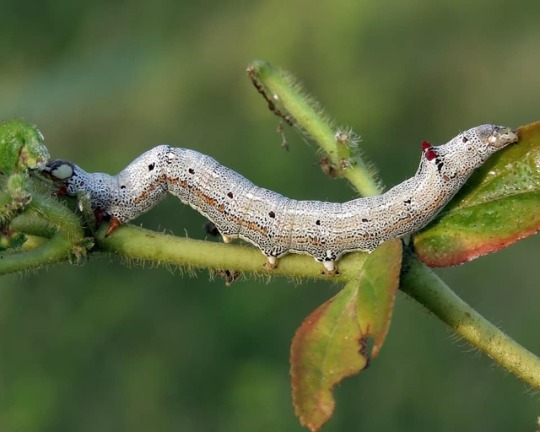
Castor Semilooper (achaea janata) is widely distributed throughout India. Though castor is the principal host plant for them, it has also been found to be predating on tea, sugarcane, pomegranate, banana, rose, grape fruits, citrus etc. Read the full article here on this link: https://farmonaut.com/blogs/plant-issues/achaea-janata-castor-semi-looper/ #castor #semilooper #plant #achaea #tea #sugarcane #banana #rose #citrus #farming #farm #harvest #agrotech #agriculture #satellite #crophealth #farmonaut #india #fruit #vegetables #crops #agro #agritech #precisionagriculture #organicfarming https://www.instagram.com/p/Bt95ffvH8OA/?utm_source=ig_tumblr_share&igshid=2m76aaihfzwq
#castor#semilooper#plant#achaea#tea#sugarcane#banana#rose#citrus#farming#farm#harvest#agrotech#agriculture#satellite#crophealth#farmonaut#india#fruit#vegetables#crops#agro#agritech#precisionagriculture#organicfarming
0 notes
Photo

Belated Happy Valentine's day! ♥️ Mo'orea is a South Pacific island and a part of French Polynesia's Society Islands archipelago. It is known for its jagged volcanic mountains and sandy beaches. Image was captured by the satellite on 23-Jan-2019. To get access to this and more satellite imagery check out our website or the android app. 🙂 https://farmonaut.com #borabora #frenchpolynesia #polynesie#polynesiefrancaise #moorea#crystalclearwater #naturalpool #nature_perfection #magical #gis #remotesensing #earthpix #earthfromabove #spacescience #satellite#tech #earth #earthscience #satelliteimagery #geography (at Mo'orea) https://www.instagram.com/p/Bt5c2wtH585/?utm_source=ig_tumblr_share&igshid=4fvmdrigy0mv
#borabora#frenchpolynesia#polynesie#polynesiefrancaise#moorea#crystalclearwater#naturalpool#nature_perfection#magical#gis#remotesensing#earthpix#earthfromabove#spacescience#satellite#tech#earth#earthscience#satelliteimagery#geography
0 notes
Video
instagram
This time lapse shows the creation of the Lower Se San 2 Dam and the reservoir resulting from it. The hydroelectric dam has been built on the Se San River, a tributary of the Mekong River, in northeastern Cambodia. Satellite Imagery accessed are from April 2017 and December 2018. https://farmonaut.com/satellite-imagery #gis #remotesensing #earthpix #earthfromabove #spacescience #satellite#tech #earth #earthscience #lowersesan2dam #sesanriver #mekongriver #river #dam #reservoir #evolution #change #hydroelectric #cambodia #asia #rural #green #construction#satelliteimagery #geography https://www.instagram.com/p/BtyGcqonjVN/?utm_source=ig_tumblr_share&igshid=5jiycipxys2c
#gis#remotesensing#earthpix#earthfromabove#spacescience#satellite#tech#earth#earthscience#lowersesan2dam#sesanriver#mekongriver#river#dam#reservoir#evolution#change#hydroelectric#cambodia#asia#rural#green#construction#satelliteimagery#geography
0 notes
Photo

A new article is released (in English and Hindi). In these articles starting from this one, we will share a farmer’s story about his/her ups and downs and the challenges which they face in day-to-day agriculture in their own words. This article is about Rajendra Prasad who is a 29 year old farmer from the state of Andhra Pradesh. Read the full article here on these links: English: https://farmonaut.com/what-it-takes-to-be-a-farmer-in-india-part-1/ Hindi: https://farmonaut.com/what-it-takes-to-be-a-farmer-in-india-part-1-hindi/ #farming #farm #harvest #agrotech #agriculture #satellite #crophealth #farmonaut #india #fruit #vegetables #crops #agro #agritech #precisionagriculture #organicfarming #greentech #agronomy #technology #tech #foodtech #foodtechnology #foodsecurity #farmerlife #urbanfarmer #urbanfarming https://www.instagram.com/p/BtdqlImnXfk/?utm_source=ig_tumblr_share&igshid=2cgz1tiokxu3
#farming#farm#harvest#agrotech#agriculture#satellite#crophealth#farmonaut#india#fruit#vegetables#crops#agro#agritech#precisionagriculture#organicfarming#greentech#agronomy#technology#tech#foodtech#foodtechnology#foodsecurity#farmerlife#urbanfarmer#urbanfarming
0 notes
Photo

Now you can share web links on the discussion forum as well. Update your app now to experience this functionality. Happy Farming!! #farming #farm #harvest #agrotech #agriculture #satellite #crophealth #farmonaut #india #fruit #vegetables #crops #agro #agritech #precisionagriculture #organicfarming #greentech #agronomy #technology #tech #foodtech #foodsecurity #farmerlife #urbanfarmer #urbanfarming #nature #kisaan https://www.instagram.com/p/BtcnMtnnQnO/?utm_source=ig_tumblr_share&igshid=1lsyhnzql5hgq
#farming#farm#harvest#agrotech#agriculture#satellite#crophealth#farmonaut#india#fruit#vegetables#crops#agro#agritech#precisionagriculture#organicfarming#greentech#agronomy#technology#tech#foodtech#foodsecurity#farmerlife#urbanfarmer#urbanfarming#nature#kisaan
0 notes