#Geoprocessing
Explore tagged Tumblr posts
Visit Tumblr Blog
Explore Tumblr blogs with no restrictions, modern design and the best experience.
Last Seen Tumblr Blogs


Fun Fact
Kazakhstan’s Minister of Communications and Informatics has blocked the Tumblr site because it contained 60 sites of terrorism, extremism, and pornography in 2015.
Text
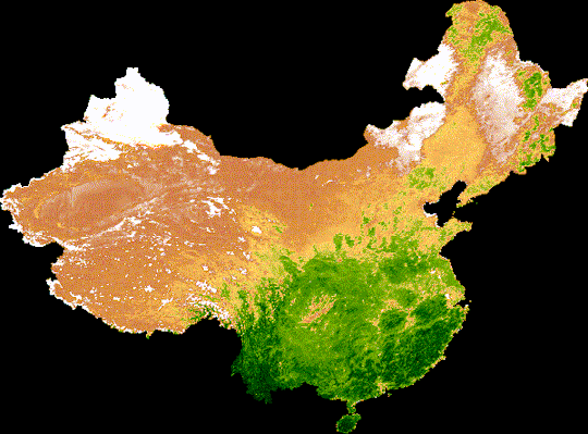
Um de nossos eixos de pesquisa são a elaboração de gifs de series temporais em NDVI ao longo do um ano para analises ambientais, no exemplo acima estuda-se o quanto o deserto de gobi da china avança e recua ao longo de um ano.
#geoprocessamento#geoprocessing#technology#techinnovation#ciencia#science#geology#agriculture#agritech#precisionagriculture#ai#artificial intelligence#machinelearng#website#maps#earth#satellite#drone#drone photography#remote monitoring#python#drought#amazon#amazonia#environment#pollution#ecology#ecosystems#climate#nature
2 notes
·
View notes
Text
Become a ArcGIS Pro Pro – GIS Mapping & Analysis Course
Take your GIS skills to the next level with this ArcGIS Pro Udemy course! 📊 Learn geospatial data processing, automation & visualization like a pro.
🚀 Get Discount 48% off (Only $12.99 from $19.99)!
#AdvancedGIS#ArcGISProPro#GISMappingSkills#SpatialData#GeospatialTech#ArcGISProExperts#GISVisualization#Geoprocessing#CartographySkills#UdemyDiscount
0 notes
Text
whoever coded the create map tile package geoprocessing tool in arcpro can eat my entire asshole
16 notes
·
View notes
Text
i open up arcgis pro (commonly known as the love of my life) and i say hiii arcgis pro here’s a nice easily handled .csv for you can i please get an imagery layer from it using the latitude and longitude data? :) and my computer fan screams so loudly you’d think i was trying to use it to launch a rocket or something. and then it crashes my geoprocessing tool halfway through
2 notes
·
View notes
Text

27•09•23
Geoprocessing day! 🛰️
12 notes
·
View notes
Text
Improve your geoprocessing productivity with Append To Existing in #ArcGIS Pro
https://www.esri.com/arcgis-blog/products/arcgis-pro/analytics/overwrite-options-arcgis-pro
0 notes
Text
QGIS Course: Unlock the Power of Open-Source GIS Software
Geographic Information System (GIS) has revolutionized the way we analyze spatial data, and QGIS stands as one of the most powerful open-source GIS software available today. Whether you are a beginner or an advanced user, enrolling in a QGIS course can significantly enhance your GIS skills. In this blog, we’ll explore the benefits of learning QGIS, what a typical course covers, and why it’s a must-have skill in various industries.
Why Learn QGIS?
QGIS is widely used for mapping, spatial analysis, and data visualization. Here’s why learning QGIS can be a game-changer for your career:
Open-Source & Free – Unlike other GIS software, QGIS is completely free, making it accessible to anyone.
User-Friendly Interface – Intuitive design and easy-to-use tools make it ideal for beginners.
Wide Industry Applications – From environmental science and urban planning to agriculture and disaster management, QGIS is utilized across various sectors.
Integration with Other Tools – QGIS supports various plugins and integrates with other GIS tools, enhancing its functionality.
What You Will Learn in a QGIS Course
A comprehensive QGIS course typically covers:
Introduction to GIS & QGIS – Basics of GIS, spatial data types, and an overview of QGIS.
Data Handling & Management – Importing, managing, and analyzing spatial datasets.
Cartography & Mapping – Creating maps with customized symbology and layouts.
Spatial Analysis – Buffering, overlay analysis, and geoprocessing techniques.
Advanced Tools & Plugins – Automation with Python (PyQGIS), 3D mapping, and raster data processing.
Real-World Projects – Hands-on exercises to apply learned skills in practical scenarios.
Who Should Enroll?
QGIS courses are beneficial for:
GIS professionals looking to enhance their expertise.
Researchers and students working with spatial data.
Urban planners, environmentalists, and government agencies.
Anyone interested in geospatial analysis and mapping.
Pie Chart: Industries Using QGIS
Environmental Service and Conservation: 30%
Urban & Regional Planning: 25%
Agriculture & Forestry: 15%
Disaster Management: 10%
Transportation & Logistics: 10%
Others (Education, Health, etc.): 10%

Conclusion:
A QGIS course provides you with essential skills to navigate and manage GIS projects effectively. Whether you're a student aiming to enhance your academic research, a professional seeking to advance your career, or a GIS enthusiast exploring new opportunities, mastering QGIS can be a game-changer. This open-source software empowers you to visualize, analyze, and interpret spatial data with ease.
At BIMMANTRA Academy, we offer a comprehensive QGIS course designed to provide hands-on experience in geospatial mapping, data manipulation, and advanced GIS techniques. Our expert-led training ensures that you gain practical knowledge applicable to real-world GIS projects.
Don't miss the chance to upgrade your skill set—enroll with BIMMANTRA Academy today and unlock the full potential of geospatial technology.
0 notes
Text
Want to become an ArcGIS Desktop 10.8 expert? 🚀
English Video tutorial, just for $9.99 (NORMAL price $19.9) till 25/02/2025. Get it once and you will get endless access right
This complete guide takes you from beginner to pro, covering essential tools, data management, and spatial analysis techniques. Whether you're a student or a GIS professional, this tutorial will elevate your mapping skills!
✅ Learn hands-on GIS workflows ✅ Master spatial analysis & geoprocessing tools ✅ Create powerful maps & visualizations
0 notes
Text
I will do gis mapping digitizing, georeferencing, spatial analysis, remote sensing
I have a 4+ years of Academic and Professional GIS and WebGIS mapping experience. I showcase my expertise using QGIS Server, Tegola, ArcGIS, QGIS, Erdas Imagine and ENVI. I specialize in performing analysis on Geographical data and to make conclusions out of it which can lead to many useful ideas may it range from a simple geographical map to deep geoprocessing of land parcels or other high detail geographical data. I am an expert in this field, and I can provide you best solutions for your business by analyzing the data through performing different GIS analysis to derive useful layers from raw data and applying different symbolization and categorization techniques on it to induce useful statistical charts and results from it in tabular format.

0 notes
Link
0 notes
Text
Ambrosia Consultoria é uma empresa focada em soluções ambientais e agrícolas, fundada pelo estudante Renan, a nossa missão é trabalhar para um futuro mais sustentável vendendo um produto simples e bem feito. Vendemos soluções ambientais para empresas, modelos agrícolas de produção, consultoria, mapas, sites, índices e gráficos, além de auxiliar a pesquisa cientifica.
#geoprocessamento#geoprocessing#technology#techinnovation#ciencia#science#geology#agriculture#agritech#precisionagriculture#ai#artificial intelligence#machinelearng#website#maps#earth#satellite#drone#drone photography#remote monitoring#python#drought#amazon#amazonia#environment#pollution#ecology#ecosystems#climate#nature
1 note
·
View note
Text

Become a ArcGIS Pro Pro – GIS Mapping & Analysis Course
Take your GIS skills to the next level with this ArcGIS Pro Udemy course! 📊 Learn geospatial data processing, automation & visualization like a pro.
🚀 Get Discount 48% off (Only $12.99 from $19.99)!
#AdvancedGIS#ArcGISProPro#GISMappingSkills#SpatialData#GeospatialTech#ArcGISProExperts#GISVisualization#Geoprocessing#CartographySkills#UdemyDiscount
0 notes
Text

Best practices for GIS testing applications involve thorough validation of spatial data accuracy, functionality, performance, and compatibility across devices. This includes testing GIS algorithms, map rendering, data integration, geoprocessing, and ensuring compliance with industry standards for reliable geospatial analysis and mapping solutions.
0 notes
Text
Exploring the Boundless Possibilities of WebGIS: Unveiling the Digital Cartographic Frontier
In today's digitally driven world, the integration of geographic information systems (GIS) and the internet has revolutionized the way we interact with spatial data. WebGIS, short for Web Geographic Information Systems, stands at the forefront of this revolution, offering a dynamic platform for accessing, analyzing, and visualizing geographical information online. From urban planning to environmental monitoring, WebGIS has become an indispensable tool for various industries and sectors worldwide.
Understanding WebGIS
At its core, WebGIS combines the capabilities of traditional GIS with the accessibility and flexibility of the internet. It enables users to access geospatial data, maps, and analytical tools through web browsers, eliminating the need for specialized software or extensive training. By leveraging web technologies such as HTML, JavaScript, and CSS, WebGIS platforms provide intuitive interfaces that facilitate seamless navigation and interaction with spatial data.
Key Features and Functionality
One of the defining features of WebGIS is its ability to integrate diverse datasets from multiple sources into a unified interface. Whether it's satellite imagery, demographic information, or real-time sensor data, WebGIS platforms can aggregate and display spatial data layers in a layered map format. Users can overlay different datasets to gain insights into spatial relationships, patterns, and trends, empowering informed decision-making processes.
Furthermore, WebGIS offers robust analytical capabilities, allowing users to perform spatial queries, geoprocessing tasks, and advanced spatial analysis directly within the browser. From identifying optimal locations for new infrastructure projects to assessing environmental impacts, these analytical tools enable users to extract meaningful insights from spatial data with ease.
Applications Across Industries
The versatility of WebGIS makes it applicable across a wide range of industries and domains. In urban planning and development, municipal governments utilize WebGIS to manage land use, zoning regulations, and transportation networks effectively. Environmental agencies leverage WebGIS for monitoring natural resources, tracking wildlife habitats, and mitigating the impacts of climate change.
Moreover, WebGIS plays a crucial role in emergency management and disaster response efforts. During natural disasters such as hurricanes or wildfires, emergency responders rely on WebGIS to coordinate rescue operations, assess damage, and allocate resources efficiently. By providing real-time situational awareness and spatial analysis capabilities, WebGIS helps save lives and minimize the impact of catastrophic events.
Advancements and Future Trends
As technology continues to evolve, so does the field of WebGIS. Recent advancements in cloud computing, artificial intelligence, and the Internet of Things (IoT) are reshaping the capabilities and possibilities of WebGIS platforms. Cloud-based WebGIS solutions offer scalability, flexibility, and accessibility, allowing organizations to store and analyze vast amounts of spatial data without the need for on-premises infrastructure.
Additionally, the integration of AI and machine learning algorithms into WebGIS enables automated feature extraction, pattern recognition, and predictive modeling. From identifying land cover changes to predicting urban growth, these AI-powered capabilities enhance the efficiency and accuracy of spatial analysis tasks, opening up new avenues for innovation and discovery.
Demystifying WebGIS:
At its core, WebGIS (Web Geographic Information System) represents the convergence of geospatial technologies and web-based applications. Unlike traditional Geographic Information Systems (GIS), which were confined to desktop environments, WebGIS leverages the internet to deliver geospatial data and functionalities to a broader audience. By harnessing the ubiquity of the web, WebGIS facilitates seamless access to geographic information from any location with an internet connection.
Empowering Accessibility and Collaboration:
One of the defining features of WebGIS is its ability to democratize geographic information. Through intuitive web interfaces, users from diverse backgrounds can effortlessly navigate maps, query spatial data, and generate custom analyses without the need for specialized software or technical expertise. This accessibility fosters collaboration among stakeholders, allowing for informed decision-making and resource allocation across various domains, including urban planning, environmental management, and public health.
Harnessing the Power of Spatial Intelligence:
WebGIS transcends mere visualization, serving as a catalyst for spatial intelligence. By integrating real-time data streams, sensor networks, and advanced analytics, WebGIS empowers users to derive actionable insights from geospatial information. Whether tracking the spread of infectious diseases, optimizing transportation networks, or monitoring natural disasters, WebGIS enables organizations to make data-driven decisions with profound implications for public safety, resource allocation, and environmental sustainability.
Navigating the Evolving Landscape:
As technology continues to evolve, so too does the landscape of WebGIS. The advent of cloud computing, artificial intelligence, and the Internet of Things (IoT) promises to unlock new frontiers in geospatial innovation. From immersive augmented reality experiences to predictive modeling and scenario planning, the future of WebGIS holds boundless possibilities for transforming how we perceive, interact with, and leverage geographic information in the digital age.
Unveiling the Essence of WebGIS
WebGIS represents a paradigm shift in the dissemination and utilization of geospatial data. Unlike traditional GIS systems confined to desktop environments, WebGIS leverages the omnipresence of the internet to enable seamless access and collaboration from any device, anywhere, anytime. Through intuitive interfaces and interactive maps, it empowers users to visualize, analyze, and interpret spatial information with unprecedented ease and efficiency.
The Rise of Geospatial Services Providers
Within the vast expanse of WebGIS, Geospatial Services Providers emerge as the cornerstone of innovation and expertise. These specialized entities offer a spectrum of services encompassing data collection, analysis, visualization, and application development, catering to a diverse array of industries ranging from urban planning and environmental management to logistics and disaster response.
Key Roles of Geospatial Services Providers:
Data Acquisition and Integration: Geospatial Services Providers adeptly navigate the complex landscape of geospatial data sources, aggregating diverse datasets ranging from satellite imagery and aerial photographs to demographic statistics and real-time sensor data. Through meticulous processing and integration, they create comprehensive geospatial databases primed for analysis and visualization.
Customized Solutions Development: Armed with a deep understanding of client requirements and industry-specific challenges, Geospatial Services Providers craft tailored solutions to address unique spatial needs. From developing bespoke mapping applications to integrating GIS functionalities into existing workflows, they empower organizations to leverage the full potential of spatial data.
Analysis and Decision Support: Leveraging advanced geospatial analysis techniques, these providers offer invaluable insights into complex spatial phenomena. Whether it's identifying optimal site locations, predicting environmental trends, or optimizing supply chain logistics, their analytical prowess equips decision-makers with actionable intelligence to drive informed choices and strategic initiatives.
Training and Capacity Building: Recognizing the transformative potential of WebGIS, Geospatial Services Providers also play a vital role in imparting knowledge and skills to stakeholders. Through training programs, workshops, and educational resources, they empower users to harness the power of spatial technology effectively, fostering a culture of spatial literacy and innovation.
Empowering Industries Through Collaboration
The impact of Geospatial Services Providers transcends individual organizations, catalyzing broader socio-economic transformation across industries. From enhancing urban resilience and infrastructure planning to facilitating precision agriculture and natural resource management, their contributions permeate diverse sectors, fostering sustainability, efficiency, and resilience in a rapidly evolving world.
Embracing the Future of Spatial Intelligence
As we stand at the nexus of technological innovation and societal advancement, the significance of WebGIS and Geospatial Services Providers becomes increasingly pronounced. With the proliferation of IoT devices, drones, and satellite constellations, the volume and variety of geospatial data continue to burgeon, presenting both opportunities and challenges on an unprecedented scale.
In this dynamic landscape, the role of Geospatial Services Providers assumes paramount importance, serving as catalysts for innovation, collaboration, and empowerment. By harnessing the transformative potential of WebGIS, they pave the way for a future where spatial intelligence becomes not merely a tool, but a cornerstone of decision-making and progress.
For More Info:-
WebGIS webgis online
digital elevation model in gis DEM in GIS DTM DTM in GIS terrain modelling in gis
spot 6 7 imagery spot 6 imagery GIS Services gis 3d modelling Digital Mapping satellite mapping
0 notes
Link
ArcGIS Pro Crack has a number of geoprocessing resources that you may use based on your needs. When it comes to managing and assessing.
0 notes
Text
My last classes in college as undergrad student
So FINALLY, I’m on senior semester and I chose some extra classes with my only compulsory class. So, here it is!
Geoprocessing: Basically, advanced studies in GeoInfo and mapping software
Costal Geomorphology: Yeah, I needed to take it again. It’s the last compulsory one, it studies the geographical forms from costal areas. I suck on this? Yeah, but I need my diploma.
Brazilian Climatology: Special topics in Brazilian climate
Climate Variability: I really dunno how explain this one… basically, what’s a normal climate variation and what’s an anomaly??? Something like that!
And, of course, I have the final grad project (a study about native plants in costal areas as a tool for mitigation of climate change’s consequences) and the internship in geography
Wish me luck! 🍀
#dark academia#light academia#chaotic academia#romantic academia#adhd academia#dark academia aesthetic#bookblr#books#studyblr brazil#geogblr#uniblr#university studyblr#my university#college classes#collegeblr#college#geography student
9 notes
·
View notes