#Tropical Weather Outlook
Text

NHC:Tropical Weather Outlook - SW Gulf of Mexico:
A broad area of low pressure is forecast to form over the
SW Gulf of Mexico late this weekend or early next week.
Environmental conditions appear conducive for gradual development of this system, and a tropical depression could form during the early or middle part of next week while it moves slowly W or WNW.
Formation chance through 48 hours…low…near 0 percent.
Formation chance through 7 days…medium…50 percent.
0 notes
Text
Atlantic Tropical Weather Outlook issued by the National Hurricane Center in Miami, FL, USA
2023-05-15 08:00 -0400
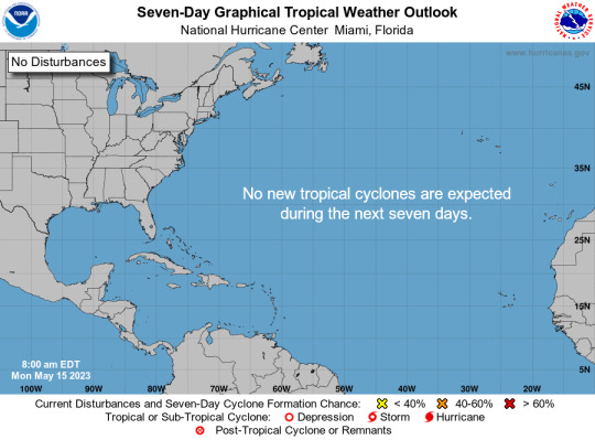
Tropical cyclone formation is not expected during the next 7 days.
Today, May 15th, marks the first day of routine issuance of the Atlantic basin Tropical Weather Outlook in 2023. This product describes significant areas of disturbed weather and their potential for tropical cyclone formation during the next seven days. The Tropical Weather Outlook is issued from May 15 through November 30 each year. The issuance times of this product are 2 AM, 8 AM, 2 PM, and 8 PM EDT. After the change to standard time in November, the issuance times are 1 AM, 7 AM, 1 PM, and 7 PM EST.
A Special Tropical Weather Outlook will be issued to provide updates, as necessary, in between the regularly scheduled issuances of the Tropical Weather Outlook. Special Tropical Weather Outlooks will be issued under the same WMO and AWIPS headers as the regular Tropical Weather Outlooks.
A graphical version of the Tropical Weather Outlook is available on the web at: https://www.hurricanes.gov.
$$ Forecaster Kelly/Cangialosi
#we are so back you guys. and now with 7 day outlooks instead of 5 day!#another year‚ another hurricane season that i leave the bot exactly how it is because i don't know how to code to improve it 👍#idk‚ maybe i'll get creative and try a few things#← mod tags‚ but:#bot post#meteorology#weather#tropical weather#tropical storm#tropical depression#hurricane#atlantic#atlantic ocean#caribbean#gulf of mexico#noaa#national oceanic and atmospheric administration#nhc#national hurricane center
7 notes
·
View notes
Text
McHart 🚗 weather outlook:

Partly cloudy skies during the evening will give way to cloudy skies overnight.


Abundant sunshine with the start of a heatwave. Temps climbing to reach a high of 102F.

Except for a few afternoon clouds, mainly sunny. Clear skies overnight.

Considerable cloudiness with occasional rain showers.

Tropical storm conditions likely with rain and thunderstorms. Rain will be heavy with torrential downpours at times by evening.
🌤️🌞🌧️⛈️
Weather the storm. 🙏🏽💗
TGW 05x04 Outside the Bubble // TGW 06x15 Open Source // TGF 01x10 Chaos // TGF 06x09 The End of Democracy
#diane lockhart#kurt mcveigh#mchart#diane x kurt#the good wife#the good fight#christine baranski#gary cole#tgw 5x4#outside the bubble#tgw 6x15#open source#tgf 1x10#chaos#tgf 6x9#the end of democracy#weather the storm
24 notes
·
View notes
Text

^^^ This one didn't amount to anything. But I thought it would be interesting to take note of the first time I noticed any tropical disturbances during the 2024 Atlantic Basin Hurricane Season. That was Friday morning May 24th. Okay, it's still technically the pre-season but NOAA went into seasonal mode on May 15th at their tropical cyclone site.
This is expected to be a more active than usual season.
This hurricane season could be among the worst in decades, NOAA warns
Warm waters across the tropical Atlantic in May 2005 prompted warnings of an active hurricane season ahead. A record-smashing 28 storms formed, including Hurricane Katrina.
Nearly two decades of global warming later, those late-spring ocean temperatures are cool compared with today’s record-hot waters. Government meteorologists issued a seasonal forecast Thursday that predicts that storms could develop at frequencies and with ferocity comparable to some of the worst seasons in the past 19 years.
The National Oceanic and Atmospheric Administration forecast — which calls for 17 to 25 tropical storms, eight to 13 hurricanes and four to seven “major” hurricanes — underscores how dramatically the environment has shifted and increased the risk of destructive weather. The prediction is the most aggressive outlook the agency has ever made ahead of the start of hurricane season.
Yes, climate change is the main suspect.
Warming is allowing major storms to form significantly earlier during hurricane season, and also encouraging more to undergo rapid intensification more frequently in parts of the Atlantic basin such as the western Caribbean Sea.
A study found that a growing number of tropical cyclones around the world have undergone what researchers called “extreme” rapid intensification, with their maximum sustained winds increasing by 57 mph or more within a 24-hour period.
The author mentioned that 2005 was a "record-smashing" season. But he did not mention that the 2005 record was itself smashed in 2020.
2020 Atlantic Hurricane Season
In 2020 we went all the way to Hurricane Iota in mid November.
Donald Trump was probably already too busy planning his coup in mid November 2020 to notice Hurricane Iota. But if he is returned to power he is essentially declaring war on Planet Earth.
No more going wobbly in climate fight, Trump supporters vow
Trump’s campaign utterances, and the policy proposals being drafted by hundreds of his supporters, point to the likelihood that his return to the White House would bring an all-out war on climate science and policies — eclipsing even his first-term efforts that brought U.S. climate action to a virtual standstill.
[ ... ]
Meanwhile, many of his former staffers are building out a comprehensive plan to decimate both climate policy and regulations on fossil fuels. And Trump allies expect that the former president would fill his next administration with officials who are even more hostile to efforts to address global warming.
Donald Trump is an enemy of the planet. The only way to defeat this real-life James Bond villain is to vote for Joe Biden.
#2024 atlantic basin hurricane season#tropical weather#noaa#tropical cyclones#warming oceans#climate change#hurricane iota#donald trump#drill drill drill#big oil#enemy of the planet#republicans#fossil fuels#election 2024#vote blue no matter who
6 notes
·
View notes
Text
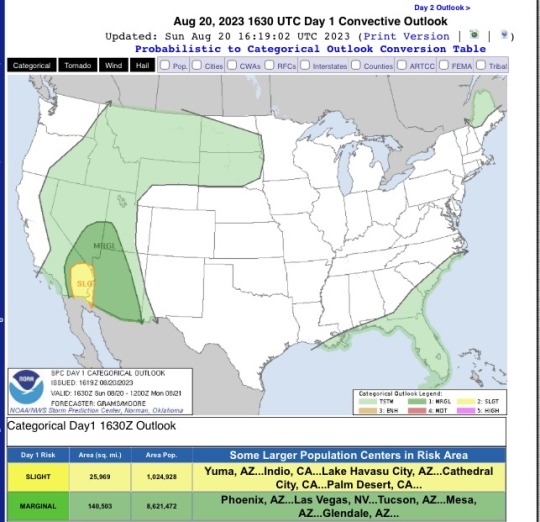
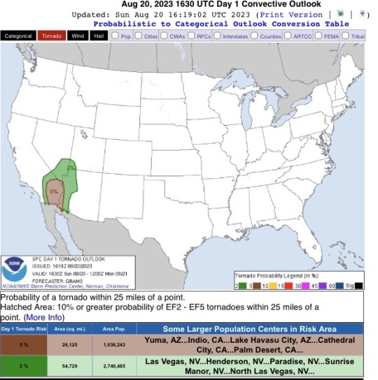

SUNDAY AUGUST 20, 2023: Southern CA, AZ, and Southern NV/UT friends, Tropical Cyclone Hilary is bringing a tornado risk today, as well as severe gusts.
Have your emergency alerts on. Be weather aware. Storm chasers in the Midwest will chase under a 2% risk. Reed Timmer is in California as we speak.
Do not downplay the risk of this weather event because that seems statistically low. It is not. That is the probability of a tornado within 25mi of ANY point in the outlook.
In the Phoenix area, which is not taking a direct hit, we are expecting gusts of 40-50mph or more. We are still getting tropical storm force winds hundreds of miles from landfall.
21 notes
·
View notes
Text
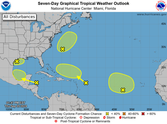
ZCZC MIATWOAT ALL
TTAA00 KNHC DDHHMM
Tropical Weather Outlook
NWS National Hurricane Center Miami FL
200 PM EDT Thu Sep 5 2024
For the North Atlantic...Caribbean Sea and the Gulf of Mexico:
1. Northwest Gulf of Mexico:
A large area of showers and thunderstorms continue in association
with a broad area of low pressure interacting with a weak frontal
boundary located over the northwestern Gulf of Mexico. Upper-level
winds are expected to become less conducive for development by late
Friday and Saturday as another frontal boundary approaches the
system. Although development is unlikely, heavy rainfall is
expected across portions of the northern Gulf Coast during the next
day or so. Additional information on this system can be found in
products issued by your local National Weather Service Forecast
Office.
* Formation chance through 48 hours...low...10 percent.
* Formation chance through 7 days...low...10 percent.
2. Northwestern Atlantic (AL99):
Showers and thunderstorms have become better organized in
association with a non-tropical area of low pressure located a few
hundred miles east of North Carolina, and recent satellite data
indicates the system is producing winds to near gale-force. This
system could acquire some tropical or subtropical characteristics
over the next day or two while it moves generally
north-northeastward, remaining offshore of the northeastern United
States. Once the low moves over cooler waters by early Saturday,
further development is not expected. Additional information on this
system, including gale warnings, can be found in High Seas Forecasts
issued by the National Weather Service.
* Formation chance through 48 hours...low...30 percent.
* Formation chance through 7 days...low...30 percent.
3. Eastern Tropical Atlantic:
An elongated trough of low pressure over the eastern tropical
Atlantic is producing limited shower activity. Development is not
expected through this weekend while the system moves little. Some
slow development appears possible early next week when the
disturbance begins moving slowly northwestward.
* Formation chance through 48 hours...low...near 0 percent.
* Formation chance through 7 days...low...20 percent.
4. Northwestern Caribbean Sea and Southwestern Gulf of Mexico:
Shower and thunderstorm activity remains disorganized in
association with a westward-moving tropical wave located over the
western Caribbean Sea. Development is not expected before the
system reaches Belize and the Yucatan Peninsula by early Friday.
Some gradual development is possible late in the weekend into early
next week after the system emerges over the southwestern Gulf of
Mexico.
* Formation chance through 48 hours...low...near 0 percent.
* Formation chance through 7 days...low...20 percent.
5. Central Tropical Atlantic:
Another tropical wave located a few hundred miles east of the
Leeward Islands is producing limited shower and thunderstorm
activity. Strong upper-level winds are expected to inhibit
development of this system during the next few days while it moves
west-northwestward at 10 to 15 mph. By early next week,
environmental conditions could become more conducive for some slow
development while the system moves over the southwestern Atlantic
Ocean.
* Formation chance through 48 hours...low...near 0 percent.
* Formation chance through 7 days...low...10 percent.
High Seas Forecasts are issued by the National Weather Service
under AWIPS header NFDHSFAT1 and WMO header FZNT01 KWBC, and online
at ocean.weather.gov/shtml/NFDHSFAT1.php
Forecaster Hagen/Delgado
2 notes
·
View notes
Note
OMG OMG FELLOW OMO LOVER AND SEVERE WEATHER ENTHUSIAST!!! sorry sorry not to be weird but I never see other people with my special interest in the wild!!!
omgggg hi!!!! i totally assumed no other omo lover would also have a special interest in meteorology!! i wanted to be a storm chaser when i was younger and i grew up in dixie alley and saw several tornadoes growing up. now i’m in FL, where i’ve been hit by several tropical systems including some major hurricanes. so severe weather seasons are like my sports season 😂 i will be glued to the radars and talking everyone’s ears off about NWS outlooks lmaooo
5 notes
·
View notes
Text
Actual weather aquí en Jax FL... AL Boris weatherman 📡🛰️🌀
3 notes
·
View notes
Text
Until a few years ago when I finally moved northward from Florida, you could have told me that apples grow in February and blackberries in March, and I’d have had little reason to disbelieve you. Moving from the tropics gave me an appreciation for when certain plants are cheaper to purchase and that snow is something to contend with, but I also had to face the reality of SAD, seasonal affective disorder.
The well-documented phenomenon of seasonal affective disorder affects roughly 10 million Americans and can crudely be summed up as a form of clinical depression tied to the changing of the seasons. Most who are affected by it feel it in the winter months, though there are many who feel depressive or even anxious symptoms in summer. The cause for the disorder is unknown, but theories range from people staying indoors due to the cold and dark, thus messing with melatonin production in the body, to an evolutionary leftover encouraging us to be more lethargic and energy-conserving due to the lack of resources our species once dealt with during the winter.
For a very long time, I was a skeptic about SAD. To a certain degree, I think it was just a lack of exposure. Most people who told me they were depressed around the holidays seemed to have the same objections I did to commercial Christmas co-opting and being forced to participate in insincere, even corny rituals. As I mentioned earlier, I grew up in Florida, a state noted for having about one percent of its population affected with SAD (compared to ten percent in Alaska).
Even more embarrassingly, I think that I dismissed the disorder out of hand just because of its criteria and name. That psychologists would go so far as to come up with an entire category of depression tied to something as trite as the weather and name it using an acronym that spelled out the word “sad” seemed indulgent at best, ridiculous at worst.
My outlook on SAD changed when I married someone who contends with it.
My wife’s seasonal background is not terribly dissimilar to my own. Before she moved to the same area of Florida in which we met, she had been born and raised in Orange County California. While we both had near-constant sunlight, for whatever reason, she actually did pay attention to whatever seasonal changes were available to her. When she eventually made her own trek to the north, I saw for the first time in the near-decade we’d known one another the true extent of what an early sunset and a sub-freezing thermometer could do to a person.
My wife is not like me: where I am (affectionately, I hope) referred to as a bit of a curmudgeon, she has a reputation for being an absolute delight. She’s pleasant and effervescent, sweet and energetic, loves people, and is always adventurous. She loves the outdoors and the fresh air, and absolutely must leave the house at least once a day or else she feels as though waking up might be a waste of precious time and opportunity.
Autumn is her favorite time of year. She loves crunching leaves underfoot and eating pumpkin-flavored anything and apples. When the mountainsides near our home turn brown and yellow, she feels a peace with the world that I envy every moment I witness it. Then the winter comes and she begins to talk about how she doesn’t want to leave our apartment anymore, how she hates that the sun sets before six and how she’s tired all of the time.
Christmas and New Year’s give her some joy for a while, but she describes February as “Dark. Cold. Depressing.” I hesitate to say that she becomes a different person—it’s more like the person I’ve always known her to be is slowed to the point that I need to work much harder at recognizing her.
More Radical Reads: Depression Is Not a Weakness
Now, anyone who has ever helped a loved one or a partner through depression is aware of how every instinct in your body cries for you to help them get better. All you want in the world is to remind them that their smile is more luminous than any summer day, and you can drive yourself to exhaustion looking for gestures and foods and conversation points that can bring them around. That’s natural and part of caring. It’s also rarely the most productive use of your energy.
There are therapies that have been used to varying level of success when it’s come to SAD: therapy using various lights and lamps is frequently used, and has been shown to have few side effects. In some serious cases, medication can be prescribed—SAD has been linked to suicidal thoughts in many cases–and any such options can and should be discussed with a mental health professional whenever possible. In most cases, explicit attention to self-care is seen as a great response.
More Radical Reads: Undo the Stigma: 10 Things Not to Say to Someone Managing Depression
For me, my job as a partner, and ally, and a witness to SAD is to just be supportive. It isn’t my place to try and step in and attempt to “fix” anything my wife is dealing with. I only need to recognize it for what it is and give it the proper attention that it always deserved and I had so much difficulty giving it for so many years.
I’m absolutely privileged to be an individual who does not suffer from SAD. I easily could have been. I have reason to believe that it may run in my family among a number of other depressive tendencies, but I’m fortunate not to. And I’m fortunate to be able to stand in for someone I care about and be there for her as she handles it in her own way. Sometimes that looks like listening and being in her presence while she contends with a dark bout for a day or so. Most times, it’s shouldering a little more of the load that we carry as a couple trying to make it through and survive and exist.
And sometimes, it’s as simple as warming her up and being a little bit brighter than I might have felt like being, just for her, just for that cold, dark day.
In order to continue producing high quality content and expanding the message of radical, unapologetic self-love, we need to build a sustainable organization. To meet these efforts, we’re thrilled to share the launch of our #NoBodiesInvisible subscription service. This service will provide our community with access to additional content and rewards for your monthly investment in furthering our radical self-love work.
[Feature Image: A photo of a person sitting on a large gate. The person is wearing blue shorts and blue sneakers. The gate is in a field of wheat. Source: Rebecca Thorp]
17 notes
·
View notes
Photo

FREE ADOPTABLE: Sunny Breeze - The Cheerful Fox
Meet Sunny Breeze, the embodiment of joy and vibrancy on the tropical sands. As a free adoptable character, Sunny is more than just a radiant figure; she carries a story as warm as the beach sun. Born on the balmy shores of the Emerald Isles, Sunny grew up basking in the golden light, which reflects in her optimistic outlook on life. Her full name, Sunniva Breezewalker, whispers of her love for long walks along the coastline, where the sea's music is her constant companion. Sunniva, or "Sunny" as she prefers, is a lover of all things bright and beautiful - from the tartness of citrus fruits to the mirthful dances of beachside festivals. She isn't fond of gloomy days or the solitude of indoor confinement, as she believes in the magic of open skies and the symphony of waves.
As a free spirit, Sunny often engages in beach volleyball, and her laughter is known to be as infectious as the rhythm of the tropics. Yet, this fox is not all play; she's a passionate environmental advocate, tirelessly working to keep her home pristine and pollution-free.
Dislikes? Rainy weather that forces her indoors, the sting of pollution affecting her beloved beach, and the taste of bitter foods that contrast her sweet nature.
Whether you're looking for a character to grace your stories or to add to your digital collection, Sunny Breeze is a perfect choice. Her story is yours to continue, and her journey is just beginning.
Comment to enter to win this adoptable, winner will be chosen randomly from all comments in one week!
Posted using PostyBirb
#AdoptableCharacter#FreeAdoptable#AnthroCharacter#TropicalFox#DigitalArt#RedFoxAnthro#BeachTheme#JoyfulCharacter#EnvironmentalAdvocate#Vibrant#SunnyBreeze
1 note
·
View note
Text
After an Atlantic hurricane season pause, are the tropics starting to stir? - USA TODAY
* After an Atlantic hurricane season pause, are the tropics starting to stir? USA TODAY
* Hurricane Season In September: What You Need To Know The Weather Channel
* September to make or break robust hurricane season outlooks Fox Weather
* Hurricane season 2024: After a quiet August, could Delaware face 'supercharged September' The News Journal
* What’s holding back the Atlantic? Analyzing slow start to ‘hyperactive’ hurricane season FOX 8 Local First
0 notes
Text
"People on the Gulf Coast and along the Eastern Seaboard can breathe a little easier. The 2023 Atlantic hurricane season, which began June 1, ends today.
The season was above-normal in terms of activity. There were 20 named storms that formed in the Atlantic basin, starting with "Unnamed Storm" and ending with "Tammy." That's the fourth-highest number in a single year since 1950." @NPR
#NPR#National Public Radio#Hurricane Season#Atlantic Hurricane Season 2023#Weather Forecasts#Tropical Weather Outlook#Tropical Season 2023
0 notes
Text
Atlantic Tropical Weather Outlook issued by the National Hurricane Center in Miami, FL, USA
2024-07-26, 14:00 EDT

Near the Lesser and Greater Antilles: An area of disturbed weather over the central tropical Atlantic Ocean is expected to interact with an approaching tropical wave during the next several days. Some development of this system will be possible while it approaches the Lesser Antilles during the early to middle part of next week and moves generally west-northwestward near the Greater Antilles toward the latter part of the week.
* Formation chance through 48 hours...low...near 0 percent.
* Formation chance through 7 days...low...20 percent.
$$ Forecaster Berg
#bot post#meteorology#weather#tropical weather#tropical storm#tropical depression#hurricane#atlantic#atlantic ocean#caribbean#gulf of mexico#noaa#national oceanic and atmospheric administration#nhc#national hurricane center
12 notes
·
View notes
Text
Atlantic 2-Day Graphical Tropical Weather Outlook
The storms are probably 5 days away minimum it usually takes them a week and they want to bring over this way as cover for their operation however
THIS IS AN ALERT THIS IS AN EMERGENCY MESSAGE. STARTING TODAY FRIDAY THE 30TH OF AUGUST THE CLONES WILL BEGIN ATTEMPTS TO DISABLE POWER SUPPLY IN SOUTHERN FLORIDA. ON THE 31ST THEY PLAN TO WITHDRAW AND TO TRY IN EARNEST THIS IS AN EMERGENCY MESSAGE
THEY PLAN ON BRINGING IN A FULL CONTINGENT OF SHIPS AND WILL NOT ALLOW ANYONE TO COME IN AND THEY WILL SECURE ALL SHIPS AND ESCAPE VESSELS INCLUDING FLY CARS PRIOR TO PULLING OUT OF COURSE ADVENTURES YES THEY HAVE STARTED DOING IT NOW.
THIS IS AN EMERGENCY MESSAGE ALL PERSONNEL TO DUTY OF OURS ALL CITIZENS ON HIGH ALERT AND TO SHELTER IN PLACE AND WAIT FOR FURTHER INSTRUCTION OR SEEK IT IN SECRECY FROM THE CO USING OUR METHOD THIS IS NOT A DRILL ALL AREAS LIKE THIS ON EARTH I'M GOING TO EXPERIENCE THIS ATTEMPT AT TERRORISM AND LARGE-SCALE TAX WITH NUCLEAR RADIATION ARE IMMINENT THIS IS AN EMERGENCY
Thor Freya
Olympus
Hera Zues
0 notes
Text
Extreme Weather: Moderate risk of unhealthy heat in one of your places
The New York Times
Aug 19 at 10:21 AM
www.nytimes.com
August 19, 2024, 10:21 a.m. Eastern time
There is a risk of extreme weather today through Wednesday in a place you said was important to you, with some days reaching a moderate-level risk. I recommend you pay attention to local forecasts for the next few days and plan accordingly.
In places with some risk of excessive or unusual heat, temperatures could be very taxing on the body, possibly causing heat exhaustion and cramps. Heat stroke is possible after spending too much time in or exercising in the sun. When this kind of heat is forecast, air quality may also worsen.
We are monitoring this heat and mapping the latest information about its intensity and duration.
— Judson Jones, reporter and meteorologist
P.S. We’ve added heat risk to this newsletter. We’ll let you know when there may be a health risk associated with abnormal or excessive heat in the locations you have chosen, based on the National Weather Service heat risk forecast. You can always change or add places to track here.
Today’s Weather News
The New York Times
Tracking Tropical Storm Gilma
See the likely path and wind arrival times for Gilma.
Read more
San Castle, Fla.
Moderate risk of extreme weather today, including unhealthy heat.
View detailed outlooks and maps
TODAY
Unhealthy heat Moderate risk
TOMORROW
Unhealthy heat Moderate risk
WEDNESDAY
Unhealthy heat Some risk
You can adjust what places to receive extreme weather alerts for at any time.
Manage places
Latest Weather News
Flash Floods Sweep Part of Long Island
Floods swept Long Island early Monday, briefly closing highways. The same storm system dumped as much as 10 inches of rain on Connecticut a day earlier.
The Dark Side of Shen Yun
The popular Chinese dance troupe has toured all over the world. But young performers described a culture of untreated injuries and emotional manipulation.
Hurricane Ernesto Brings High Swells and Strong Rip Currents to the East Coast
Ernesto was creating dangerous surf conditions that were expected to continue for several days, forecasters warned.
Sources: The risk levels shown are derived from categories used in the outlooks issued by the National Weather Service, including those for severe weather from the Storm Prediction Center and excessive rainfall and winter storm conditions from the Weather Prediction Center. Some of these categories have been combined to create a clear, consistent language across multiple weather hazards. For more information, see the “About the data” section of the detailed outlooks page.
Need help? Review our newsletter help page or contact us for assistance.
You received this email because you signed up for Your Places: Extreme Weather from The New York Times.
To stop receiving Your Places: Extreme Weather, unsubscribe. To opt out of other promotional emails from The Times, including those regarding The Athletic, manage your email settings. To opt out of updates and offers sent from The Athletic, submit a request.
Subscribe to The TimesGet The New York Times app
Connect with us on:
Change Your EmailPrivacy PolicyContact UsCalifornia Notices
The New York Times Company. 620 Eighth Avenue New York, EXTREMELY AMAZING 🥲 choir boy 🤮trump NEVER 👎 used trafficked young girls to staff casinos https://gab.com/Demosthenes100964outlookcom/posts/112991378608899857
#youtube#aviation#boeing#beautyangel#bethereforservicemembersandveterans#delivery#avgeek#tiktok#facebook
0 notes
Text

ZCZC MIATWOAT ALL
TTAA00 KNHC DDHHMM
Tropical Weather Outlook
NWS National Hurricane Center Miami FL
200 AM EDT Thu Aug 8 2024
For the North Atlantic...Caribbean Sea and the Gulf of Mexico:
Active Systems:
The National Hurricane Center is issuing advisories on Tropical
Storm Debby, located on the coast of South Carolina.
1. Near the Lesser and Greater Antilles:
An area of low pressure could form in the central or western
tropical Atlantic Ocean early next week. Some development of this
system is possible while it approaches the Lesser Antilles during
the early to middle part of next week and moves generally
west-northwestward toward the Greater Antilles thereafter.
* Formation chance through 48 hours...low...near 0 percent.
* Formation chance through 7 days...low...20 percent.
Forecaster Bucci
2 notes
·
View notes
Last Seen Blogs

pubettrash
Sans titre

punishedbanana
banana is superior fruit

alohamylove
for surl 🌵

airmasters
Air Masters Heating And Air Conditioning Inc

decky4012
Declan