#historical cartography
Text
is there anything sexier than uncovering historical illustrations of cities? seeing little peeps of a city landscape in a portrait, or a full spread illustration dedicated to the city itself, showing you how it was centuries ago... I could look at these all day.
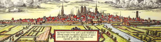
(view of Münster, 1570)
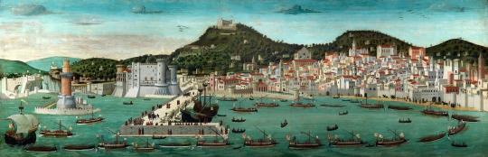
(view of Naples, 1470)
#Like a timestamp... a photograph... Except sexier than a photograph.#Every time I see medieval or early modern depictions of European cities up until the 1700s I just. So good#text#chey.txt#history#historical cartography
5 notes
·
View notes
Text
Obsessed by the sheer number of sea monsters on this map of Africa that I came across! This is only 1/4 of it, and look at how many the cartographer put in!!! Convinced this expanse of ocean beyond Madagascar was included just so he could put in the sea monsters.
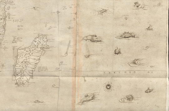
And lots of close-ups, because you need to see them!!!


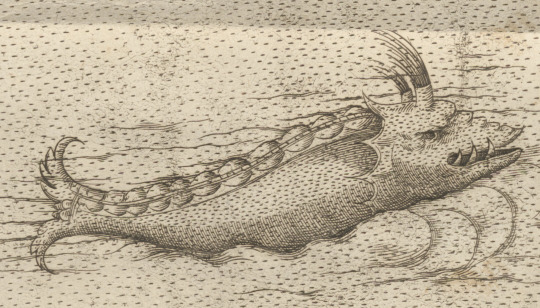
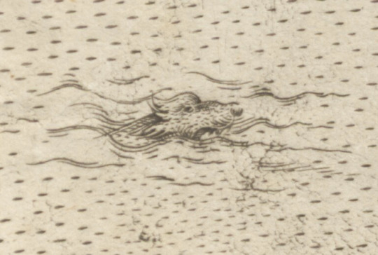

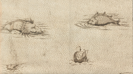
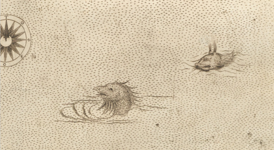
And a link to the source (Il disegno della geografia moderna de tutta la parte dell'Africa, Giacomo Gastaldi, 1564) so you can all have fun seeing them up close and personal too: https://www.digitale-sammlungen.de/en/view/bsb00092152?page=,1
#early modern italy#early modern period#early modern history#sea monster#cartography#early modern cartography#africa#the range of these sea monsters oh my goodness i am losing my mind#giacomo gastaldi#Il disegno della geografia moderna de tutta la parte dell'Africa#maps#old maps#historical maps
64 notes
·
View notes
Text


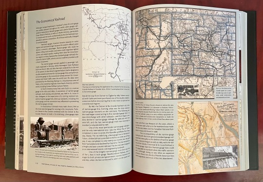
Book 481
Historical Atlas of the North Pacific Ocean: Maps of Discovery and Scientific Exploration 1500–2000
Derek Hayes
British Museum Press 2001
Derek Hayes has authored many books of maps, and it shows. This one is much better. More maps, more specific, more detail images, and it includes incidental illustrations documenting voyages. Featuring maps from the voyages of Sir Frances Drake, James Cook, George Vancouver, Matthew Perry, the first sonar map of the Pacific, physiographic diagrams of undersea topography, plate tectonics, tsunami maps, satellite images, and hundreds more, this book covers over 500 years of people trying to understand the North Pacific rim.
#bookshelf#library#personal collection#personal library#books#bibliophile#book lover#illustrated book#booklr#maps#Derek Hayes#historical atlas of the North Pacific Ocean#British museum press#cartography
14 notes
·
View notes
Text

This guy again, but he‘s a bit younger in this one and on his first real expedition
Might replace this with the colored version some other time
#don‘t worry#the gun isn‘t loaded#league of legends#ezreal#fanart#drawing#art#lineart#historical design#cartography#league of legends fanart#league of legends ezreal#arcane#arcane show#league of legend art
44 notes
·
View notes
Text
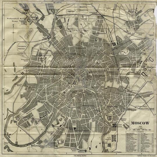
An 1893 map of Moscow, Russia.
4 notes
·
View notes
Photo

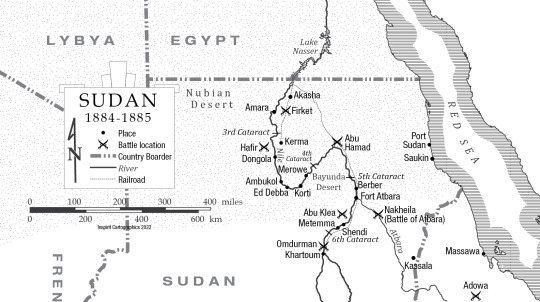
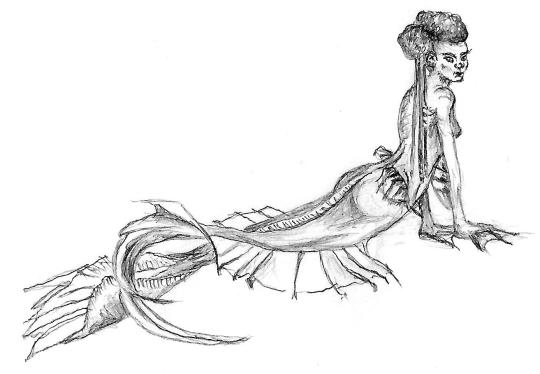
Historical map of Sudan. A mermaid was requested as an embelishment for this one. I didn’t think a disney-like one was very Nile-esque so I came up with this. Fortunetly she was well recieved.
#sudan#historical maps#mermaide#sketch#handdrawn#africa#maps#cartography#custom made#custom maps#Inspirit cartographics
85 notes
·
View notes
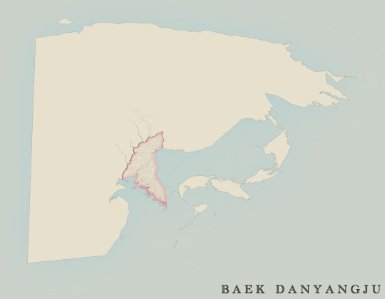
Text
Yulguk
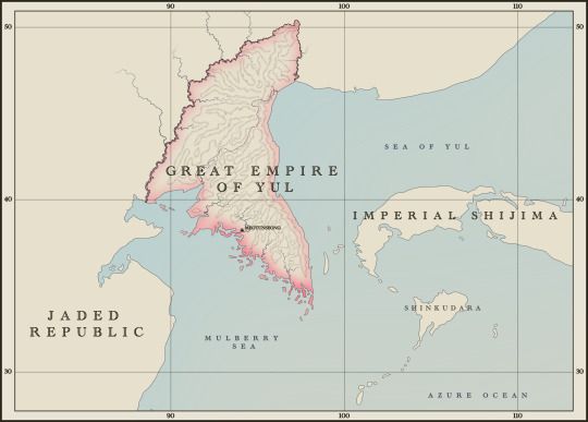
대율제국, daeyul jeguk, the Great Empire of (the) Yul
Other names: Yulguk, Yulnara, Yul Country, Bando, the Peninsula
Capital: Meotunseong (name pending)
Government: constitutional monarchy
Geography: MOUNTAINS with some plains in the west + many coastal islands
Climate: like Korea’s
Rambly “Historical Context”:
(not proofread)
30 years after Saseom-ae (Shijimian) occupation invasions were repelled by a combination of Long, Yul restorationist, eastern Maljok, frontier warlord, and Bellian forces, Yulguk and the rest of the realm of Danyangju have only now been able to wearily emerge from the shadows of the Sandalwood Wars.
The Sandalwood Wars started as the logical conclusion of the empire-building done by Danyangju’s two eastern giants: the Samyukta and Long. The former vied to reestablish an old history of dominance in the southern Jo Danju region, which the latter had locked down through an extended tributary system. Initially fighting through proxy wars by supporting various usurper and incumbent powers, the conflict spiraled into open war. Hence started the Red Sandalwood War.
In the northern Baek Danju region, Imperial Shijima, whose clashes with the bloated Long Empire over influence on the Yul Kingdom and disruptive Shijimian settlers resulted in increasing economic isolation, sought an alliance with Samyukta and hence attacked the Yul and Long not long after war had started in the southern seas. Imperial Shijimian forces occupied the peninsula on the pretenses of restoring the clique of royal in-laws who the Long had ousted from power due to destabilizing peasant rebellions. The White Sandalwood War hence began, and with it, one of the longest, worst decades in Yul history since the Millennium War.
To be concise, fortunes began to turn as Yul resistance coalesced around the rightful heir to the throne, now known posthumously as King Geumjong. Supported by lower aristocrats and military leaders, he allied with northern frontier gangs and sought an alliance with Bellia, who hosted a formidable Yul diaspora that had grown during the regressive reign of the royal in-laws. Several Yul had been appointed to high offices and so heeded the plea—though not without concessions to be made in the future. As aforementioned, Geumjong’s coalition, fractured Long forces, and unsteady support from the inland Maljok turned the tides.
Shortly after the Sandalwood Wars concluded, a painful reconstruction and readjustment period began for the now-Great Empire of Yul—allowed to exist thanks to the destruction wrought upon the Yul’s former imperial master, the deposed Long. King Geumjong uneasily bowed to pressure from the Bellians, people, and lower aristocrats to form a constitutional monarchy.
Bellian advisory, military, and business forces now occupied the peninsula, brewing unease and imposing restraint on policy in the name of self-preservation and self-strengthening. Namely, the nebulous territories of the north were not administered as part of Yulguk. Many advisors and professionals across the realm formerly distributed to the Yul by the Long Empire were courted once again, this time to directly serve the king and prime minister. Not all improvements and changes were appreciated. When some of Geumjong’s former military allies rebelled against the Bellians and officeholders of the new republic, the rest of the army competently put the insurrection down, playing a part in Bellia’s ultimate physical withdrawal from the mountainous land.
What followed next was a decade of hardline, nationalist, paranoid, and heavy-handed policy openly supported by Geumjong. Prime ministers during this decade pursued a small war against the reconstituted Jaded Republic over the Long Empire’s former frontier territories, ending in expansion and the creation of two new northern provinces after diplomatic meetings deescalated the conflict. Xenophobia ran rampant, purging “foreign” officials and appointees from their posts. The dominant party also (il+)legally purged their opponents wherever they could and even stoked fear within their own ranks. Immigration restrictions intended to ensure that a devastated labor supply could not shrink any further, while funding was gutted for foreign study trips and diplomatic missions. The generally repressive atmosphere clashed with a steadily recovering, growing middle class that wanted universal suffrage.
The murder of Supreme Prosecutor Jak Noljin (name pending) by Gil Yong-gi and its investigation played a role in turning public opinion firmly against the conservative coalition. Jak’s younger brother, foreign envoy Jak Heungjin, was the liberal-aligned suspect that the investigation doggedly pursued, as the murder took place at his residence during the celebration of his son’s high examination scores. He also had lost a suit against Gil years earlier, who refused to restore Jak’s post after the latter returned from an extended spousal mourning period.
Yet, an overabundance of evidence pushed by liberal-aligned officials in the justice system later leaked to independent presses stoked public unrest, as opponents of the conservatives framed this incident as an attempt of judicial murder. Not to mention, it was also an example of the vicious climate brewing among the party itself, as people speculated that higher-ups could have ordered the elder Jak to be killed for going against party interests with his rumored investigation of Gil’s embezzling activities. Even Geumjong, who had long supported the party, publicly expressed that he would serve justice himself if he had to, preemptively vowing to pardon the surviving Jak before his execution.
Triumphantly, Gil was charged and executed instead, averting mass outcry.
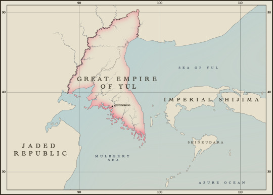
The next decade was far more liberal, preceded by Geumjong’s stroke-induced death and the ascension of the current queen. In gratitude for awarding them a new majority, the liberal coalition enacted universal suffrage, regardless of income. The quality of life across the peninsula had by then mostly improved, although industrialization and urbanization ensured that turmoil continued. The most prominent feature of this decade was active foreign policy and economic pursuits, spawning the growth of a notable tourism industry. However, the increased circulation of people and goods also brings with it stress and disease, and an epidemic has recently only just begun to end. Ultra-nationalism once again lurks, ready to strike out against new cultural and social change while economic stratification entrenches itself as the new evil of Yul society.
It is at the tail end of this decade that the “present” story of Jakho unfolds. (think like the 1880s)
#jakho#fantasy cartography#fantasy map#map#interactive fiction#twine wip#twine game#twine if#cartography#korea#joseon#historical#if wip#if game#history#yulguk
18 notes
·
View notes
Photo

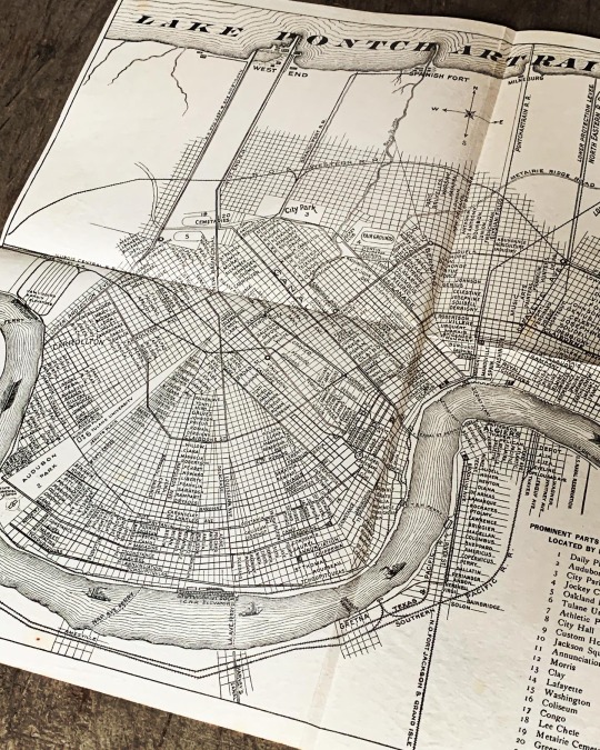

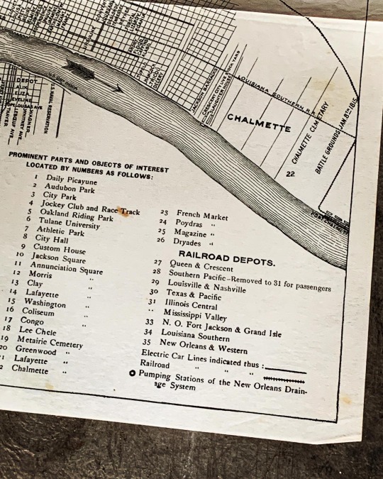
1904 TIMES PICAYUNE NOLA MAP
Rare and original 1904 TIMES PICAYUNE’S Map of New Orleans , ready to frame. Not many of these around , the only ones I found are in Universities / State collections
Item No. E498-73
Dimensions: 19” x 16”
List Price: $ 250
504.581.3733 / t
#antiques#new orleans antiques#cartography#nola#the times picayune#1904#old new orleans#historic new orleans#wall decor#interiors#new orleans map#magazine street antiques
5 notes
·
View notes
Text

This was a map that I put together for a friend, both to test how long it would actually take me to make a map of this complexity, and because he was playing a tabletop miniatures game set during the eponymous Boshin War. Unlike a great deal of my other maps, this is a straight historical map, insofar as it was possible to get accurate details of the various domains of the Tokugawa shogunate at this time and the routes of the various main roads used in the country at that time.
3 notes
·
View notes
Text
Detroit: An Intricate Dance of Urban Life Map
by: Sophia Casab-Casab
Exploring Detroit’s data set whilst taking into account its fascinating historical narrative, I knew I wanted to take these concepts hand in hand and present a project that had a compelling message. But there’s a crucial step in between—making sense of the data. This transformation is not just about presenting numbers and figures; it’s about crafting visual metaphors that…
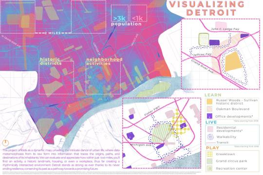
View On WordPress
#2023#cartography#dance#Detroit#geography#Greektown#historic district#map#Oakman Boulevard#open data#Russell Woods#Sophia Casab-Casab#urban life#Visualizing Detroit
0 notes
Text
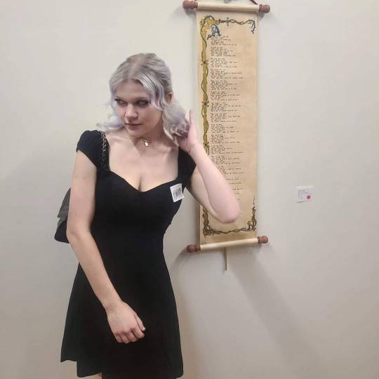
Hello Tumblr! I wanted to have another cozy space to share my art with new people so this is the beginning for me. I recently had my first ever solo art exhibition and these are the pieces I created for it! I'll be making separate posts with more detailed shots of each piece as well.
I make traditional art using a dip pen, India ink, and watercolors. I am primarily interested in cartography but I love to do ink illustrations and practice calligraphy as well. I hope you enjoy!

"Duggard Reel" 12" x 36"
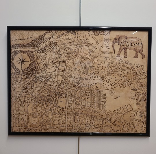
"The University of Alabama" 24" x 32"
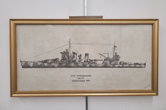
"USS Tuscaloosa in Profile" 10" x 20"
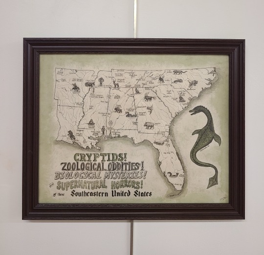
"Cryptids of the Southeast!" 16" x 20"
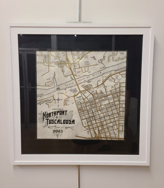
"Tuscaloosa & Northport, Downtowns of" 18" x 18"
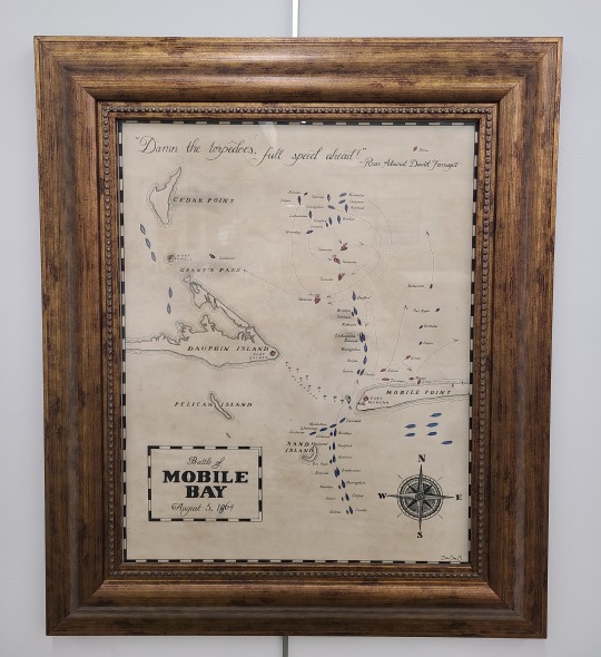
"Battle of Mobile Bay" 16" x 20"
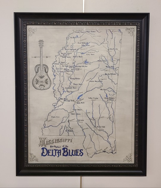
"Birthplace of the Delta Blues" 21" x 27"
#cartography#cartografía#maps#art history#my art#handcrafted#traditional art#calligraphy#handwriting#manuscript#medieval art#fantasy art#historical#scroll#illuminated manuscript#local artist#alabama#southern#artists on tumblr#small artist
1 note
·
View note
Text
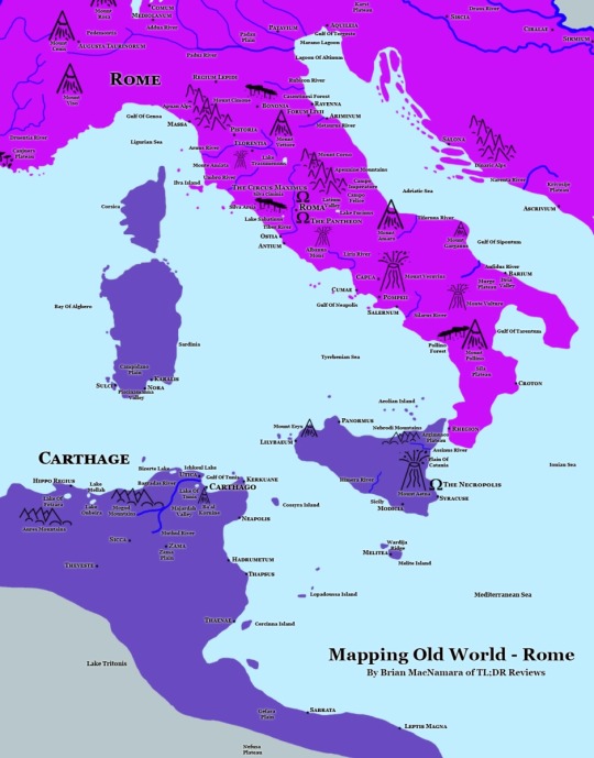
Mapping Old World– Map-It
TL;DR – We continue our project of mapping historical video games with a look at Mohawk Games’ Old World
Mapping Old World –
One of the joys I have discovered working on this site has been our mission to map historical video games. We started with Civilization, followed up with Humankind, and our next mission is Old World. I had played a bunch of Old World when it was back in beta, and now that…
View On WordPress
0 notes
Text
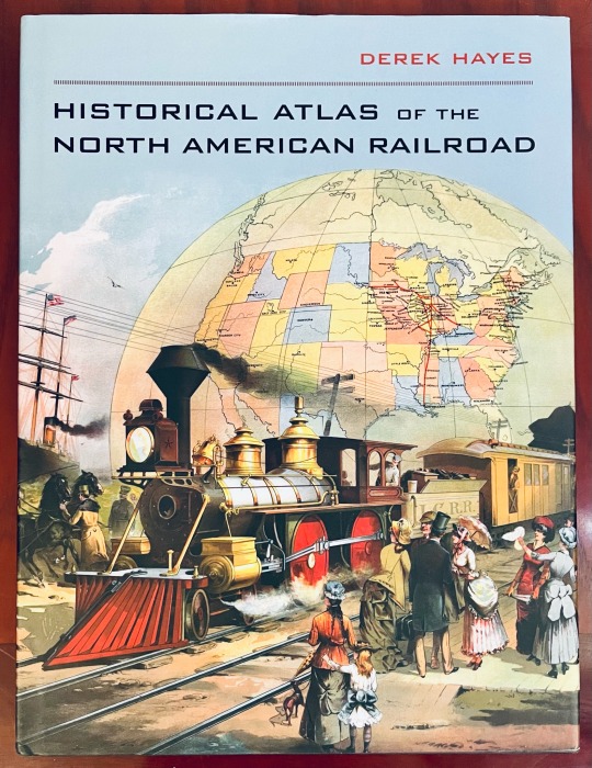
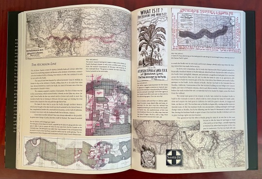


Book 504
Historical Atlas of the North American Railroad
Derek Hayes
University of California Press - 2010
So, the thing I like about this library project is that it forces me to pick up books I haven’t touched in years, and then I remember why I brought them home in the first place. Like this one. If you’re a book pack rat like me, I highly recommend it.
Derek Hayes has created a minor cottage industry with his cartography books. He’s authored at least ten of them, of which I think I have three. I’m not really a big train guy, but I am definitely a map guy. With nearly 400 railroad maps, historical photos, posters, brochures and other assorted ephemera, this is an excellent collection of how the railroad transformed the continent.
#bookshelf#library#personal collection#personal library#books#bibliophile#book lover#illustrated book#booklr#historical atlas of the North American railroad#derek hayes#university of california press#UC press#cartography#maps#history
0 notes
Text
Lost Islands: The Story of Islands That Have Vanished from Nautical Charts :: Henry Stommel
Lost Islands: The Story of Islands That Have Vanished from Nautical Charts :: Henry Stommel

View On WordPress
#978-0-7748-0210-9#books by henry stommel#existent islands#exploration history#first edition books#high seas#historical nautical charts#history cartography#history expeditions#hydrography#islands#maritime history#maritime myths#nautical history#naval history#oceans#rear-admiral g&039;s ritchie#royal navy#sailors#seafaring#victoria barbut
0 notes
Text

Above is a 1760 map of the eastern parts of North America.
#North America#United States#Canada#British Empire#Colonial America#history#cartography#map#historical#18th century#I own nothing#art
0 notes
Text

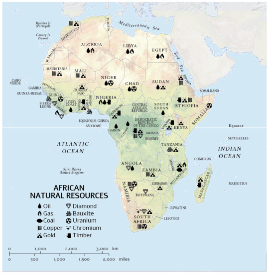
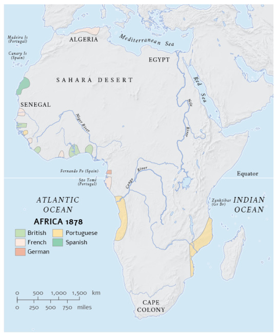
A series of historical maps of Africa I made for an African Atlas
5 notes
·
View notes
Last Seen Blogs

xoilacchamtv-com
Xoilac TV

thetenantfanfic
The Tenant

scottfotografia-blog
Scott Photograper

massartvideotwo-blog
VideoTwo

soldier-however
Untitled