#old maps
Explore tagged Tumblr posts
Visit Tumblr Blog
Explore Tumblr blogs with no restrictions, modern design and the best experience.
Last Seen Tumblr Blogs


Fun Fact
Post activity is at the highest at 4:00 pm EDT; notes peak at 10:00 pm EDT.
Photo

Map Of Europe In The Form Of A Queen, Engraving And Letterpress, 1587
110 notes
·
View notes
Text

57 notes
·
View notes
Note
Would it be possible to get a Millard Nullings from Miss Peregrine’s Home for Peculiar Children? With themes of like ink, books, old maps, main color palette themes would be like tans, browns, burgundy, gold, I don’t know what the aesthetic is called sorry!
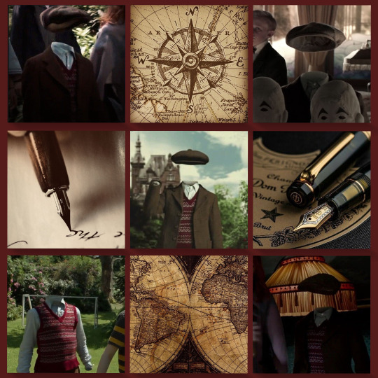
Millard Nullings (Miss Peregrine's Home for Peculiar Children) moodboard with themes of old maps and ink!
so sorry I missed the book part, i skimmed over it on accident 💔
#otherkin#alterhuman#otherkinity#alterhumanity#alterhuman moodboard#otherkin moodboard#fictokin#fiction kin#fictionkin#millard nullings#millard nullings moodboard#millard nullings fictionkin#miss peregrines home for peculiar children#mphfpc#maps aesthetic#old maps#ink#ink aesthetic
22 notes
·
View notes
Text
I FINALLY found a pre-1948 globe:

This has been a thrifting goal of mine for so long. It's out of my price range but so cool to see.
9 notes
·
View notes
Text

The Lebanese city of Tyre, as pictured in a circa 17th-century copy of Kitab-ı Bahriye (Book of Seafaring) by Ottoman cartographer Piri Reis (ca. 1465–1533). More of his beautiful maps here: https://publicdomainreview.org/collection/the-maps-of-piri-reis/
Israel is currently bombing Tyre entirely for spite and the US is gladly giving Israel more munitions as Netanyahu goes on a murdering war crime spree. Tyre is one of the oldest continuously inhabited places on the planet and chock full of world heritage sites...but Israel is throwing a genocidal temper tantrum so I guess it will all just go to shit.
29 notes
·
View notes
Text

February 2025
9 notes
·
View notes
Text

A little Fanart of Dimension20's the Never After map, I absolutely adored that campaign!
#dimension 20#d20#dnd art#maps#map art#dimension twenty#neverafter#fairy aesthetic#cottage aesthetic#old maps#dnd5e#dungeonsanddragons#ttrpg art#ttrpg maps#fanart#myart#my fanart#original art#pastel colors#old aesthetic#dnd#digital illustration#digital art#small artist#hand drawn#fairytale#folktale
103 notes
·
View notes
Text
History speaks for itself.


#history#truth#politics#palestine#facts#old maps#maps#books#holy land#bible#old testament#do some research#researchers#research#israel
93 notes
·
View notes
Text

Map of the proposed Barataria and Lafourche canal and lock system - 1911.
#vintage illustration#vintage maps#maps#cartography#rivers#louisiana#old maps#bayous#parishes#coastline#canals#coastal erosion#floods#flooding
5 notes
·
View notes
Text

Le Poulpe Colossal | 1801
Made by malacologist Pierre Dénys de Montfort, 1801, from the descriptions of French sailors reportedly attacked by such a creature off the coast of Angola.
6 notes
·
View notes
Text

#curators on tumblr#wanderlust#li_destinations#travel#explore#compass#globe#historic#map#maps#old maps#vintage map#vintage
38 notes
·
View notes
Text


#collage#pirates#pirate life#cthulhu#old maps#octopussy#emily dickinson#emily dickinson poetry#our flag means death#A real proper pirate#stivaktis#tin tin
4 notes
·
View notes
Text


Indigenous nations of the Americas. Sometime I wanna come back to this and add more, like Tikigaq, Blackfoot confederacy and the Purepecha empire. But for now this is quite nice imo
#Americas#Aztec#maya#Inca#Iroquois#Sioux#Lakota#Comanche#art#map#maps#artist#illustration#native american#old maps#digital art#artists on tumblr
3 notes
·
View notes
Text


1. Mapa Português de 1502, onde se encontram representadas as Seychelles
Restantes fotios: Carlos J. Martins Nobre
3 notes
·
View notes
Text

November 1914 Bicycle and Automobile Map of Belgium -- back roads and trails
#WWI#bicycle#bicycling#back roads#old maps#Belgium#Luxembourg#France#Netherland#Germany#1914#bicycle trails#resistance#train#occupation
6 notes
·
View notes
Text


My current mood -- with images I pulled from Pinterest.
#dark academia#dark acadamia aesthetic#dark academia moodboard#wellies#old books#old maps#cappuccino
29 notes
·
View notes