#nautical weather instruments
Explore tagged Tumblr posts
Visit Tumblr Blog
Explore Tumblr blogs with no restrictions, modern design and the best experience.
Last Seen Tumblr Blogs


Fun Fact
The total number of visits Tumblr.com received during January 2021 is 327 million.
Note
what does "bust a bravo" mean
smile
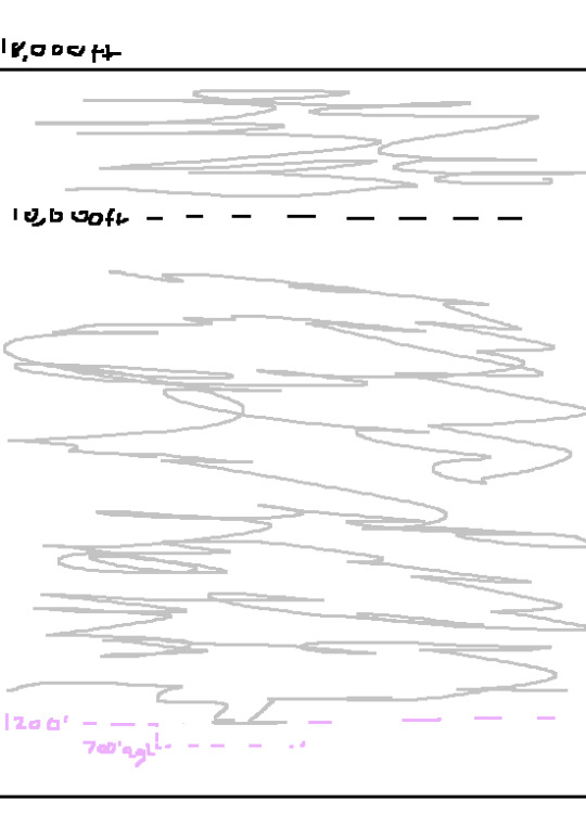
ok gang! lets learn about The National Airspace System! (referenced with AIM chapter 3 and PHAK chapter 17)
We'll start off easy with Uncontrolled Airspace! Class G or Golf airspace is Completely uncontrolled. Theres nobody there watching to maintain spacing or really anything, however you still have to maintain the minimum weather requirements for Visual Flight Rules.
Those rules are as follows, For Daytime flying less than 1200 feet Above Ground Level (hereby condensed to AGL), you must maintain 1 statute mile of visibility (think fog obscuring how far you can see) and remain clear of clouds. For Daytime Flying above 1200 AGL its 3 Statute miles of visibility, 1000 feet above clouds, 500 ft below, and 2000 feet horizontal. if its Night time flying below 1200ft AGL, its 3 statute miles, 1000ft above, 500ft below, and 2000ft horizontal around clouds. These numbers are very Very common, and will be condensed into the "3-152" Rule. Night time above 1200ft AGL is also the 4-152 rule.
NOW! Where IS class Golf airspace? Well, it starts from the surface all the way up to 1200 feet AGL. Sometimes its to 700ft AGL but we'll explain why that is when we get into Controlled Airspace.
so basically it looks like Such:

Next up: controlled Airspaces!
first one is class E or Echo, which stands for EVERYWHERE. Where is Echo? EVERYWHERE but uncontrolled, or other Defined airpspaces. Class Echo starts at 1201ft AGL, and goes alll the way up to 17,999ft MEAN SEA LEVEL. Mean sea level (or MSL) is the height above where the ocean Approximately is. So if you're 0ft MSL, you're basically swimming. All (most.) aircraft Altimeters (the instruments that tell you how high you are) are calibrated to what the air pressure outside is at mean sea level and indicate how high they are compared to where MSL is.
Back to Class E airspace. E goes up to 17,999ft MSL, because at 18,000ft it changes to a different airspace, which we will get to in a moment. So, Class E is Controlled airspace, but that doesnt mean you have to be talking to people to fly in it. in fact, most people flying in class E arent actually talking to air traffic control! most of the time they're flying around Visually, under Visual Flight Rules, which means "i can see outside and where im going, and i can navigate this way."
so how do you fly in E under Visual flight rules? well, by flying in it. but they do have to have weather minima above the 3-152 Rule. Except over 10,000 ft, which is when it changes to 5-111. 5 Statute Miles visibility, 1000 feet above, 1000 feet below, 1 mile horizontal.
Class E also has Speed regulations! anywhere under 10,000ft is limited to 250 Knots (nautical mile per hour) and above 10,000 its just. mach 1. you cant break the speed of sound. FUN!
in some specific areas, (most of the time over airports) the Class E airspace is Lowered, to allow the controlled airspace to be closer to an uncontrolled airport. This is visualized on a VFR sectional chart as a shaded magenta area, kinda looking like a circle. This lowering is done for Instrument Flight Rules purposes, but im not an Instrument flight instructor so i cant teach on that yet. sorry.
so basically, E looks like This:
Next up is the Fun ones!
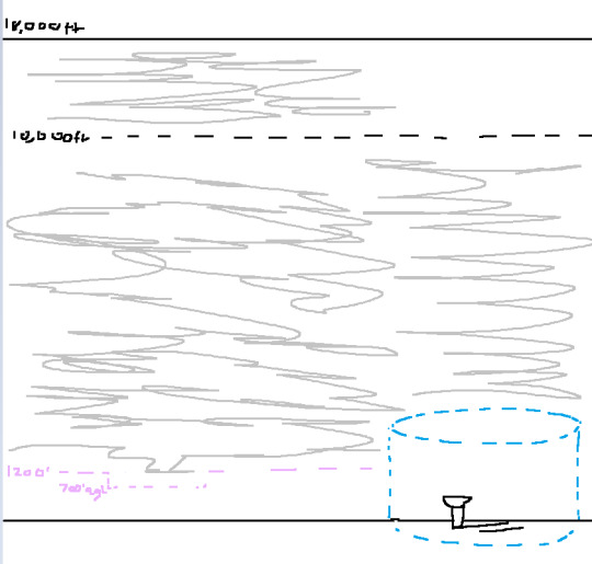
Class Delta airspace is usually surrounding a 5 statute mile radius around a Towered airport, from the Surface to 2500ft AGL. Some airports don't have towers, which places them in Uncontrolled airpspace, aka Class Golf! you can just take off and land however you want! on towered fields however, you have to maintain two way radio communication with the controlling agency of the field. you're flying around, 10 miles out you go "Gateway Tower, Skyhawk N123AV, 10 miles to the south, full stop" and they reply "Skyhawk 3AV, enter left base runway 9." once you hear your callsign "skyhawk 3AV" you know you're allowed into the airspace, unless given specific instruction otherwise.
Class Delta has the same 3-152 rule for VFR. and is depicted on a sectional chart as a dotted blue circle around an airport.
it looks as Such:
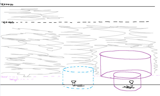
Next up, is class Charlie, or C.
Charlie is a lot bigger, think your local international airport. Nashville, Tucson, Oklahoma city, Little Rock. These are Big airports, but not like. HUGE. not like atlanta or JFK or LA. those are their own catagory which we will get to.
Class C is defined as a 5 mile radius from surface up to 4000 ft AGL! a lot taller! But, theres a catch~ theres an outer circle, with a 10 mile radius, from 1200ft agl to 4000ft agl. think an upside down wedding cake with tiers. they can change around to have more than just 2 different sections but most class C's look like this.
VFR is 3-152, and you must have 2 way communication to enter their airspace. however, because this airspace is so much bigger, they usually have an Approach controller, who you contact before getting close to the tower. they have different controllers to contact for different directions you're coming from. Fun! you also need to have a Mode C transponder. this is a device that sends information to ATC's Radar, giving Altitude information and a dot of where you are on their little map.
They're Depicted on a sectional chart as solid magenta lines, as opposed to shaded magenta lines
Class Charlies:
Finally. we get to answer Anon's BURNING QUESTION: what is "busting a bravo?"
well, we must talk about Bravo airspace. B, stands for BIG. not really, but like, these airspaces are extremely complex, absolutely massive, and are routed specifically for the airport and its arrivals, departures, and approaches. they're highly customizable and very fun to deal with! (lie)
these are your Pheonix sky harbors, your JFK's, your LA's, your San Diegos, your Atlantas. Massive Airports with EXTREMELY high traffic, and airports very close by.
For class bravos, you only have to be 1 statute mile of visibility, and clear of clouds, day or night, to operate VFR. but what are the chances you're operating vfr in a bravo anyways? not very high. still need to know that for a checkride, though. theres also a 30nm ring surrounding them, which requires a Mode C transponder inside of that "mode C veil"
Class bravos are signifigantly more strict on whos allowed to fly into them. before, in D or C, you just needed to hear your callsign and be able to enter, otherwise you'd be busting through their airspace. However, with class Bravo? you have to be Cleared into the bravo. they have to say "Skyhawk N123AV, you are Cleared into the class bravo airspace" before you're allowed in. otherwise, they WILL call your ass over the radio and go "skyhawk N123AV, were you cleared into my airspace?" "skyhawk n123av, no." "alright, skyhawk N123AV, i have a number for you to call when youre on the ground, advice ready to copy" which indicates you are FUCKED. you have to call and explain why you were in that airspace when you were not supposed to be. this is a very very bad thing and Not something you want on your record.
But!!!! if you're busting that airspace as a student, your CFI is at fault, because they're the one supposed to be seeing and avoiding, and preventing you from breaking airspace you shouldn't be.
anyways, Bravos are depicted as solid blue lines on a sectional chart, and "look like this":

woof! thats a lot! and every airspace we gotta think about!
hm? whats that? i forgot one?
oh right! above 17,999ft! thats right! well, thats Class Alpha airspace! its the most controlled and restricted airspace, because you CANNOT operate under visual flight rules in there. at all! you must be under Instrument Flight Rules to fly in class Alpha airspace. once you pass 17,999, you enter the "Flight Levels" which are indicated as FL180, and go all the way up to FL600, or 60,000 ft. thats, really high up. Nobody goes up there, except the SR-71 blackbird. You really dont ahve to think about class A until you get to your Instrument rating, which im not qualified to teach, so. scram.
if you have ANY questions or think i missed something, feel free to correct me, i dont know everything. once again i referenced AIM chapter 3 and PHAK chapter 17 for all of this information.
30 notes
·
View notes
Text
tuesday again 1/16/2024
did not commit fratricide this week but it got a little close there
listening
spotify tried to rec me some electro remix of this Eartha Kitt song i did NOT care for but i did enjoy the original Mink Schmink (YouTube). very similar to last year’s favorite Peel Me A Grape by Anita O’Day. this is a particular kind of oldies #girlboss song that i am super weak to
i also have an entire album to rec! spotify recced me a movie soundtrack by this artist and i went to check out their latest work. a very pleasant outer space themed saxophone-forward experience to enjoy while trying out a very slow video game! the opening track Chaldene will let you know pretty fast if you’ll like the whole album. bouncy, in the ways that saxophones are. very cowboy bebop soundtrack adjacent? i have a data entry playlist with many instrumental albums of long pieces for when i need really consistent vibes or vibes that change very slowly and this is going to be such a good addition
reading
feeling a little bit grim about the state of the world and long-tail reporting/continuity of knowledge, partially bc some friends got fired from the games industry and are throwing in the towel (do not blame them at ALL, also now this means i don't know anyone in the industry with more than three years of experience under their belt) and partially feeling a little bit grim bc i read an article FOREVER ago from the old motherboard team at VICE about how locations were being harvested from various religious and health apps, and FINALLY that data broker is starting to see some real consequences. the ONLY reason this reporter is still following this story/is still a reporter is bc after VICE summarily fired like half the site last year, he went off and started his own site.
grim! grim article, grim context, grim all around.
watching
i would love for my best friend's son to become obsessed with a different movie than pixar's elemental. but if this is the price of having an only semi-interrupted conversation with his mom then so be it.
playing
“sail forth” by developer Quantum Astrophysicists Guild and published by Festive Vector (pair of really killer names there) is the free epic game this week. i spent a reasonably okay hour with it but do not plan to continue further. the opening area has some problems that do not interest me in whatever this game does in the next area. tldr: the actual sailing part is fun, which is good bc it's a sailing game, but there isn't enough to Do in this adventure/exploration game and it's all really far apart.

it has a particular sensibility married with its art style that makes me say “cozy game” (derogatory). your main character is named captain toot. everyone has funky sentence structure liberally sprinkled with nautical terms that come off vaguely nonsensical instead of piratical. there are a lot of almost-kennings like “deepblue” “moontiders” “fishfolk”. things of this nature. while i do love a kenning i don’t have a lot of patience for this. which is unfortunate bc this game tested my patience in several ways.
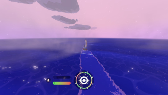
the actual Sailing part is the best part of the game. there's some very fun weather-- i have seen light and heavy fog, light and heavy rain, and a full on thunderstorm. the fact that sailing is the best part of the game would be good except everything is VERY far apart, and while the call of a blank horizon is super important in an oceangoing game (i think) when it becomes more fun to just fast travel everywhere instead of sailing the long way, i think that’s where you have to refine some things in your game. this is less of an open world and more little pockets of things in between a truly ridiculous amount of empty space. i cannot imagine this runs in an acceptable manner on switch.

the good parts of sailing are the thoughtful controls: the compass, the wind on the compass, and the little sail trim bar. you should also keep an eye on wave direction bc that will really impact your top speed. you CAN tack back and forth directly into the wind but this game will make you fucking work for it, which i do like. i also liked sailing with the camera zoomed all the way in, it felt very fast and dangerous on the very long wait to get to the next island. and then it was no longer fun on the very long sail to get to the next island. i am almost confident these islands are procgen, it’s possible i got a weirdly big seed but i don’t care enough to fire up a new save.
the general pace of the game/this first area feels a little underbaked or weirdly optimized. i got enough wood in the first hour to upgrade to the best available one-mast sloop, i fought a pirate which required a lot of precision seamanship with my one lonely bow gun, i did a race, i declined a target practice course, i poked my head into eight different map locations. despite this variety, it all felt very samey. generally the map locations have one or two things to do plus one resource (the precision seamanship required to collect resources is fun for the first two islands but then stops being interesting) or one collectible. no one island is particularly memorable. i really loved Sunless Sea, a game that also features a large map and very slow travel, but there’s a WAY more resource management and random events, and shit is simply closer together in that game.
if i was looking for a very slow podcast game and was 20% cutesier as a person this would be ideal, but for who i am right now? not for me.
making
my siblings visited! we did not kill each other, nobody had food poisoning, and nobody died! that's all i can really ask for. here's me and my sister looking at a big quilt at the 1940 Air Terminal Museum

phil went to the emergency vet sunday afternoon bc her spay site was looking Gnarly. she either has an infection or a reaction to her sutures but the treatment is the same either way. the emergency vet said we could probably skip our normal vet visit on friday but, given that we discover a new problem every time we go to the vet, we will be keeping that appointment. all recent pics of her are smushed up on my lap at a goofy angle. have a pic of mackaroni and beans

29 notes
·
View notes
Note
I don't write but I am interested in what you would recommend for writing about preparing for a flight in a light aircraft realistically. Even for drawing. While reading your blog I remembered some story or something describing a scene in the back seat of a small plane like a cessna 172 and I just couldn't imagine any of it well because i know that space is too dang tight.
Also, just out of curiosity
What are some examples of planes that you can instruct in? Are we talkin cessna or piper or beechcraft or?
Hi!
I instruct in the Piper PA-28 series of aircraft, and a basic flight plan is typically done in the few hours preceding a flight, or the night before in the case of an early-morning flight.
Step one is to determine where you want to go, and if the weather will even allow for it to happen. Assuming you're in the USA, aviationweather.gov and 1800wxbrief.com are the two most useful websites for flight planning. This step is a "big picture" glance at the route of flight, and this is when you actually draw your lines on a map to plan out your route.
Once the weather looks okay and your route is planned, the next step is to designate a set of "checkpoints" along your route of flight, be they landmarks on the ground for VFR (visual) flight, or navigation waypoints for IFR (instrument) flight. The purpose of these is not only to remember what to look for, but to help figure out your ETA with some math you'll be doing later in the planning process.
All of these waypoints are written down in a document called a nav log, which is essentially a table describing your route, the waypoints along them, estimated speeds, estimated times, etc. Once all of your waypoints are picked out, you tally up the distances between them (in nautical miles), and make sure that number matches the total distance.
Now, with your route and waypoints, it's time to take a closer look at the weather. Since we already know we'll be clear of any nasty weather, now is the time to focus on one important thing: what the wind is doing.
Using the websites above, we can get a forecast of the wind speed and direction at our desired altitude, which is chosen based on what provides the best tailwind (or least-bad headwind). Our altitude, assuming a VFR flight, follows the hemispherical rule - eastbound flights fly at an odd-thousand altitude plus 500, and westbound flights fly at an even-thousand altitude plus 500. Add the wind speed/direction, as well as the desired altitude, to the nav log.
Now, here's the part where we do the math, and for this, we'll use a special calculator called an E6B. It's a slide rule whose design has been almost unchanged since the Second World War, and it can do unit conversions, course corrections, fuel burn calculations, and much more. What we want right now is the wind correction function - given a desired course, a wind speed, and a wind direction, it can calculate a ground speed (faster with a tailwind, slower with a headwind), as well as a wind correction angle, which is a heading to keep the airplane from being blown off course by the wind.
We need to do a wind calculation for each of our waypoints, adding the wind correction and ground speed to our nav log.
Now that we have our estimated ground speeds at each waypoint, we calculate our estimated time enroute (ETE) between each waypoint, again using the E6B to do so and adding the results to the nav log. Add up the ETEs between each waypoint to get an ETE for the entire route.
After that's done, we'll calculate how much fuel we need. Consult the airplane's manual for a fuel burn measured in gallons per hour (GPH), which is 9.5 GPH for the PA-28. Do the math with the E6B, and you now have your cruising fuel.
Next, climb fuel - for this one, you need to consult the airplane's manual, and follow the directions on a graph to get this number.
Finally, reserve fuel - for a VFR flight during the day, you need enough fuel to cruise to your destination, and then fly at a normal cruising speed thereafter for 30 minutes.
For a VFR flight at night, or an IFR flight, you need 45 extra minutes of fuel, plus any fuel needed to fly to an alternate airport in the case of IFR.
Those are the basic elements of a flight plan, but there's more that pilots are required to familiarize themselves with:
- NOTAMS (notices to air missions; typically concerns airport closures or non-standard procedures)
- Weather information (it's always good to do one more look at the weather, and also obtain a weather briefing for your route of flight)
- Known delays (ground stops, busy airspace, etc)
- Runway lengths at airports of intended use
- Alternative airports to land at if your destination is no longer suitable
- Fuel requirements
- Takeoff and landing performance numbers (can your airplane take off and land within the length of the shortest runway you plan on using?)
- Any other information pertinent to the flight
11 notes
·
View notes
Text
Brass Spyglass Beauty - A Vintage Treasure For Coastal Décor Lovers
When it comes to capturing the true essence of the sea, few decorative pieces compare to the timeless elegance of a brass spyglass. This vintage maritime instrument, once used by explorers and ship captains, has now found a new life as a captivating addition to nautical decor. Whether displayed on a bookshelf, mounted on a wooden tripod, or nestled inside a handcrafted wooden box, the brass spyglass adds a unique blend of history and sophistication to any coastal-themed space.

At Handcrafted Nautical Decor, we celebrate the beauty of maritime heritage with our exclusive collection of antique nautical spyglass pieces. These handcrafted collectibles are not only visually stunning but also functional replicas that tell the story of seafaring adventures and timeless exploration.
Why the Brass Spyglass is a Coastal Decor Essential
A brass spyglass isn't just an ornament—it's a statement piece. Its gleaming metal body and precision detailing make it an instant focal point, ideal for coffee tables, mantels, or office desks. Whether you're designing a cozy beach cottage, a modern coastal condo, or a marine-inspired study, a brass spyglass brings authenticity and charm to your setting.
The antique nautical spyglass adds depth to your décor by connecting the present with the golden age of exploration. It's more than décor; it’s a piece of history reimagined for modern interiors. From maritime collectors to beach house owners, anyone with a love for the sea will appreciate the elegance of this iconic piece.
Featured Brass Spyglass Pieces to Elevate Your Decor
Explore some of our standout pieces from the Handcrafted Nautical Decor spyglass collection, each designed with care and historical accuracy:
Captain’s Solid Brass Spyglass 15” with Wood Box – A polished gem that blends luxury and nostalgia, ideal for office shelves or living room accents.
Admiral’s Antique Brass Spyglass 27” with Tripod – A striking floor piece with adjustable height, perfect for creating an old-world ambiance.
Brass Spyglass 6” with Rosewood Box – Compact and elegant, it’s the perfect gift for nautical collectors or to enhance small display spaces.
Vintage Nautical Brass Telescope 18” – A slightly larger and more rugged option, great for rustic coastal themes.
Each piece reflects the quality and heritage that Handcrafted Nautical Decor is known for, ensuring you get more than just a decorative item—you get a maritime heirloom.
The Appeal of Antique Nautical Spyglass in Modern Design
The antique nautical spyglass fits beautifully into a wide range of styles. Whether you’re going for a shabby chic look, a traditional nautical vibe, or a more polished Hamptons-style décor, this versatile item blends seamlessly with other coastal elements like ship wheels, compasses, model ships, and rope accents.

Pair your brass spyglass with weathered wood furniture, neutral color palettes, and soft marine blues to achieve a relaxed and luxurious coastal aesthetic. You can also mix it with modern minimalist pieces for a striking contrast between old and new. The possibilities are endless.
A Nautical Decor Must-Have
If you're curating a room inspired by the sea, a brass spyglass is one piece you shouldn't overlook. It adds instant character and evokes the adventurous spirit of sailors and navigators. As a part of our wider nautical decor collection, these items are designed to help you create a space that’s as refreshing as an ocean breeze and as classic as a captain’s journal.
At Handcrafted Nautical Decor, we are proud to offer a wide variety of antique nautical spyglass designs that cater to both collectors and everyday decorators. Each item is handcrafted to perfection, using authentic materials that reflect the craftsmanship of historic maritime tools.
Final Thoughts
Whether you're updating your beach house, adding a maritime theme to your living space, or searching for the perfect gift for a sea-loving friend, a brass spyglass from Handcrafted Nautical Decor offers beauty, history, and timeless appeal. Let this exquisite piece remind you of distant shores, ocean adventures, and the charm of vintage exploration.
Connect with us on social media to explore more nautical treasures and styling tips that bring your coastal vision to life!
0 notes
Text
Understanding World Hydrography Day: Mapping Our Oceans for a Sustainable Future

Understanding World Hydrography Day: Mapping Our Oceans for a Sustainable Future
Introduction to World Hydrography Day
Every year on June 21st, the global community observes World Hydrography Day to recognize the critical role hydrography plays in safe navigation, maritime trade, ocean science, and environmental protection. Instituted by the International Hydrographic Organization (IHO) in 2005, this day raises awareness about hydrography's significance in understanding the physical characteristics of oceans, seas, coastal areas, lakes, and rivers.
Hydrography, in simple terms, is the science of measuring and describing the physical features of bodies of water and the land areas adjacent to them. With rising concerns around climate change, marine pollution, and sustainable ocean governance, the relevance of hydrography has grown substantially.
What is Hydrography?
Hydrography involves collecting data on water depth, tides, currents, seabed composition, and shoreline structure. This information is crucial for creating nautical charts and other navigation tools that ensure safe maritime operations. Beyond navigation, hydrographic data supports coastal zone management, underwater infrastructure development, and scientific research.
Hydrographers use sophisticated equipment such as multibeam echo sounders, LiDAR, and satellite positioning systems to create accurate and detailed maps of underwater terrain. These tools allow scientists and policymakers to monitor environmental changes, manage marine resources, and improve disaster preparedness strategies.
The Importance of World Hydrography Day
Promoting Maritime Safety
Hydrography is essential for ensuring the safety of ships and cargo in transit. Updated nautical charts, derived from hydrographic surveys, help mariners avoid hazards like submerged rocks, sandbanks, and shipwrecks. World Hydrography Day emphasizes the importance of maintaining accurate hydrographic data to reduce maritime accidents and enhance global trade routes.
Environmental Monitoring and Climate Resilience
With rising sea levels and more frequent extreme weather events, hydrographic data is instrumental in modeling coastal erosion, flood risks, and habitat shifts. This data helps governments and scientists implement climate-resilient policies, such as designing better coastal defenses and predicting storm surges.
Supporting the Blue Economy
The blue economy refers to the sustainable use of ocean resources for economic growth, improved livelihoods, and ocean ecosystem health. Hydrography underpins sectors like offshore energy, aquaculture, shipping, and tourism by providing reliable marine data. World Hydrography Day showcases how hydrography supports a balance between development and sustainability.
Celebrating World Hydrography Day Around the Globe
Government and Institutional Events
On June 21, various national hydrographic offices, maritime organizations, and research institutions organize seminars, exhibitions, and webinars. These events highlight advancements in hydrographic technology, data sharing initiatives, and the role of hydrography in international maritime law.
Countries like the United Kingdom, India, Japan, and the United States play a significant role in promoting hydrographic education and infrastructure. Their hydrographic offices collaborate with the IHO to standardize data formats, train professionals, and promote global maritime safety.
Educational Outreach and Awareness
Schools and universities conduct awareness programs to educate students about hydrography's applications and career opportunities. Interactive workshops, model-making contests, and documentary screenings are popular activities that engage young minds in understanding the importance of ocean mapping.
Technological Demonstrations
Tech companies and oceanography institutes often use this day to showcase their latest hydrographic instruments and innovations. From drone-based surveys to AI-powered data analysis tools, technology is continuously expanding the scope and accuracy of hydrographic studies.
The Role of the International Hydrographic Organization (IHO)
The IHO, established in 1921, is the leading authority coordinating hydrographic activities across the world. It sets global standards for charting, surveying, and data exchange. The IHO also ensures that nations have access to up-to-date nautical information to support safety at sea and protect marine environments.
World Hydrography Day was created by the IHO to bring attention to the often-overlooked science of hydrography. Each year, the organization announces a theme that reflects current global challenges or technological progress, such as marine data innovation, coastal resilience, or climate action.
Future Challenges and Opportunities in Hydrography
Bridging the Data Gap
Despite technological progress, large areas of the ocean floor remain uncharted. World Hydrography Day serves as a reminder of the urgent need for more comprehensive marine mapping, particularly in developing countries where hydrographic capabilities may be limited.
Leveraging AI and Remote Sensing
Artificial intelligence, machine learning, and satellite-based remote sensing are revolutionizing hydrography. These technologies offer faster and more cost-effective solutions for analyzing vast datasets, detecting anomalies, and predicting changes in marine environments.
Collaborating for Global Impact
Cross-border collaboration is vital in hydrography. Shared data initiatives, joint surveys, and multilateral agreements can help build a unified approach to ocean governance and conservation. World Hydrography Day encourages international cooperation to ensure our oceans are mapped, monitored, and managed efficiently.
Conclusion
World Hydrography Day is more than a celebration—it’s a call to action. It reminds us of the invisible yet invaluable work that hydrographers do to make our oceans safer, more sustainable, and better understood. As we face mounting environmental challenges, hydrography will play a pivotal role in shaping the future of our planet’s water resources.
Recognizing and investing in this field is critical not only for maritime operations but also for climate resilience, biodiversity protection, and economic development. By embracing innovation and global collaboration, we can ensure that hydrography continues to light the way beneath the waves.
0 notes
Text
Electronic Navigational Charts Market Analysis, Size, Share, Growth, Trends, and Forecasts 2023-2030

The Electronic Navigational Charts (ENC) market emerges as a crucial player, steering the course towards safer and more efficient sea journeys. Unlike traditional paper charts, electronic navigational charts have become indispensable tools, harnessing the power of cutting-edge technology to redefine the maritime industry.
Get a Free Sample Report:https://www.metastatinsight.com/request-sample/2538
Who are the largest manufacturers of the Electronic Navigational Charts Market
worldwide?
Maryland Nautical
Lloyd's Register OneOcean
Wärtsilä Corporation
Caim Scrl
OceanWise Limited
Poseidon Navigation Services Ltd.
Japan Hydrographic Charts and Publications Co., Ltd
Boeing (Jeppesen)
American Nautical Services, Inc.
StormGeo
Fontanski Marine Supply
In the Global ENC market there are electronic charts that seamlessly integrate with advanced navigation systems, offering mariners a real-time, digital representation of the surrounding waters. This technological shift has significantly enhanced navigational accuracy and situational awareness, mitigating the risks associated with maritime travel. The Mariners now rely on electronic charts for precise information on water depths, hazards, and navigational aids, ushering in a new era of reliability and efficiency.
Access Full Report @https://www.metastatinsight.com/report/electronic-navigational-charts-market
The Global ENC market's significance extends beyond mere navigational aids, encompassing a comprehensive ecosystem of software, hardware, and services. Electronic charts, with their dynamic layers of information, provide a multifaceted view of the maritime environment, facilitating not only safe navigation but also efficient route planning and optimization. This comprehensive approach contributes to fuel efficiency, cost savings, and a reduced environmental impact, aligning with the industry's growing emphasis on sustainability.
Moreover, the Global ENC market has catalyzed the development of sophisticated Electronic Chart Display and Information Systems (ECDIS). These systems have become instrumental in revolutionizing bridge operations, enabling seamless integration of data from various sources. The integration of ENC data with real-time information such as weather conditions, traffic patterns, and port data empowers mariners to make informed decisions swiftly, fostering a safer and more streamlined navigation process.
As the maritime industry continues to evolve, the Global ENC market stands at the forefront of innovation, addressing the evolving needs of vessel operators, shipping companies, and regulatory bodies. The market's adaptability is evident in its embrace of emerging technologies such as artificial intelligence, machine learning, and data analytics, further enriching the capabilities of electronic charts and navigation systems.
The Global Electronic Navigational Charts market is not merely a collection of charts and software; it represents a transformative force shaping the future of maritime navigation. Its impact extends far beyond the immediate realm of charts, influencing the very fabric of how mariners navigate and manage their vessels. As the industry sails into uncharted waters, the Global ENC market stands as a beacon of innovation, guiding maritime stakeholders towards a safer, more efficient, and technologically advanced future.
Global Electronic Navigational Charts market is estimated to reach $905.7 Million by 2030; growing at a CAGR of 6.0% from 2023 to 2030.
Contact Us:
+1 214 613 5758
#ElectronicNavigationalCharts#ElectronicNavigationalChartsmarket#ElectronicNavigationalChartsindustry#marketsize#marketgrowth#marketforecast#marketanalysis#marketdemand#marketreport#marketresearch
0 notes
Text
Your Maritime Journey with a Diploma in Nautical Science
Introduction –
Are you someone who dreams of exploring the vast oceans, navigating through challenging waters, and embarking on exciting adventures? If so, a Diploma in Nautical Science might be just the thing for you!
A diploma in nautical science is your ticket to stepping into the fascinating world of maritime exploration and adventure. But what exactly does it entail, and how can it kick-start your maritime career? Let's dive in and explore!
1) What is Nautical Science?
Nautical science is the study of navigation, seamanship, and maritime operations. It covers everything from understanding the principles of navigation to mastering the art of sailing a ship safely and efficiently across the seas.
2) Why Choose a Diploma in Nautical Science?
A diploma in nautical science provides you with the essential knowledge and skills needed to pursue a career as a deck officer on merchant ships. It offers a balanced blend of theoretical learning and practical training, equipping you with the expertise to handle various aspects of ship operations.

3) What Will You Learn?
During your diploma program, you'll cover a wide range of subjects, including: -
Navigation Techniques: - Learn how to plot courses, use navigational instruments, and navigate safely through different types of waters.

Ship Stability: - Understand the principles of ship stability and stability calculations to ensure the safety of the vessel and its crew.
Meteorology: - Study weather patterns and learn how to interpret weather forecasts to make informed decisions while at sea.
Cargo Handling: - Gain knowledge about the loading, stowing, and securing of cargo on-board ships.

Maritime Law and Regulations: - Familiarize yourself with international maritime regulations and legal requirements governing ship operations.
4) Career Opportunities –
Upon completing your diploma in nautical science and obtaining the necessary certifications, you'll be eligible to work as a deck officer on various types of merchant vessels, including container ships, bulk carriers, tankers, and passenger ships. Deck officers play a crucial role in ensuring the safe navigation and operation of ships, making this a rewarding and fulfilling career path for those passionate about the sea.

Conclusion –
A diploma in nautical science opens up a world of opportunities for those eager to embark on a maritime career. With comprehensive training, hands-on experience, and a wealth of career prospects, it's the perfect choice for anyone with a love for the sea and a thirst for adventure. So, if you're ready to set sail towards a bright future, consider enrolling in a diploma program in nautical science and chart your course to success on the high seas!
0 notes
Text
Navigating the Seas: The Indispensable Role of Boat Compasses

In the boundless expanse of the open sea, where the horizon stretches endlessly in every direction, sailors and seafarers rely on a steadfast companion Compass for a Boat. Often overlooked but undeniably essential, these marine compasses serve as the guiding stars for maritime navigation, offering a reliable means of orientation amidst the vast blue unknown.
The Unsung Heroes of the Open Sea In the maritime world, the boat compass stands as an unsung hero, silently aiding sailors in their quest to conquer the waves. Unlike the familiar terrestrial compasses used on land, marine compasses are specially designed to withstand the challenges of the open sea. These nautical instruments play a crucial role in guiding vessels through the labyrinth of waterways, where every direction appears remarkably similar. ᅠ ᅠ ᅠ ᅠ ᅠ ᅠ ᅠ ᅠ ᅠ ᅠ ᅠ ᅠ ᅠ ᅠ ᅠ ᅠ ᅠ ᅠ ᅠ ᅠ ᅠ ᅠ ᅠ ᅠ ᅠ ᅠ ᅠ ᅠ ᅠ ᅠ
Precision in Design Crafted with precision and engineered for durability, boat compasses are a testament to the marriage of technology and tradition. The design of these nautical navigational tools incorporates features that account for the unique conditions of seafaring. Immune to the magnetic interference of the ship itself, these compasses provide accurate readings even in the midst of the vast metal expanse of a boat.
The Cardinal Points at Sea Navigating the open sea requires an understanding of the cardinal points—North, South, East, and West. Boat compasses serve as the compass rose of the sea, offering a visual representation of these cardinal points to guide sailors in plotting their course. In the absence of visible landmarks, the boat compass becomes an indispensable tool for maintaining the right heading and ensuring a safe voyage.
Overcoming the Challenges Sailing brings its own set of challenges, from unpredictable weather patterns to the rolling motion of the waves. Boat compasses are designed to provide stability and accuracy, allowing sailors to navigate with confidence even in adverse conditions. In the hands of a skilled navigator, a boat compass becomes a reliable ally, steering the vessel through the ever-changing seascape.
Technological Advancements While traditional compasses have served sailors for centuries, modern boat compasses embrace technological advancements. Some are equipped with built-in GPS systems, providing additional navigational support and enhancing precision. These innovations ensure that sailors have access to the latest tools to make their journeys safer and more efficient.
Click here for more information :-
Boat Navigation Lights
Airmar Transducer
0 notes
Text
Mastering the Waves with a Diploma in Nautical Science
Preparing for Success
Diploma in Nautical Science is a call to seafaring adventure, not just an academic endeavor. Let's explore this unusual curriculum where students become their own leaders.
Construction of Nautical Knowledge
The curriculum is a well constructed blueprint to knowledge's unknown oceans. Each subject—astronomy, ship stability, and meteorology—points to maritime competence.
Navigating the Unknown: A Study of Charts and Navigation
In Navigation and Chart Work, students read maps and understand maritime language. A dance with charts and instruments converts coordinates into a precise navigation symphony.
Navigation by Stargazing Seafarers
Celestial Navigation makes sailing art. In a sky-based universe, students become celestial cartographers using the sun, moon, and stars.
Balance: Ship Stability as Oceanic Choreography Ship stability is a wave dance, not a topic. Students become marine conductors who safely navigate by learning weight distribution and stability calculations.
Cloud Decoding: A Seafarer's Weather Almanac Meteorology deciphers the sky's message, not only the weather. Student atmospheric linguists study clouds and wind patterns to forecast weather.
Practical Skills: Sea Trials and Hands-On Expeditions Real test comes at sea. Practical training is a baptism into ocean unpredictability, not a simulation. From navigating rough seas to managing goods, pupils become one with nature.
Setting sail: Future careers With a Diploma in Nautical Science, graduates navigate their careers, not merely find jobs. The ocean of potential awaits those who navigate business waterways or command ships.
Conclusion: Beyond the Horizon | Nautical Science
Diploma in Nautical Science is a compass for students, not a degree. Each graduate becomes a captain navigating the endless possibilities with a unique combination of academic and practical knowledge. The trip is a lifelong exploration of marine excellence, not just a certificate.
0 notes
Link
4 Min Read NASA C-130 Makes First-Ever Flight to Antarctica for GUSTO Balloon Mission NASA's Wallops Flight Facility C-130 aircraft delivered the agency’s Galactic/Extragalactic ULDB Spectroscopic Terahertz Observatory (GUSTO) payload to McMurdo Station, Antarctica, on Oct. 28, 2023. The GUSTO mission will launch on a scientific balloon in December 2023. Credits: NASA/Scott Battaion On Oct. 28, 2023, NASA’s C-130 Hercules and crew safely touched down at McMurdo Station, Antarctica, after an around-the-globe journey to deliver the agency’s Galactic/Extragalactic ULDB Spectroscopic Terahertz Observatory (GUSTO). The United States research station, operated by the National Science Foundation, is host to NASA’s Antarctic long-duration balloon campaign in which the GUSTO mission will take a scientific balloon flight beginning December 2023. The C-130 crew, which has now completed half of the 26,400-nautical-mile round-trip journey, first stopped at Fort Cavazos, Texas, on Oct. 17, to load the GUSTO observatory and members of its instrument team. Additional stops to service the aircraft and for crew rest included Travis Air Force Base (AFB), California; Hickman AFB, Hawaii; Pago Pago, American Samoa; and Christchurch, New Zealand, before finally reaching McMurdo, Antarctica – a mere 800 miles from the South Pole. Aircraft Office teams prepare the C-130 aircraft for departure at NASA’s Wallops Flight Facility in Virginia. The aircraft will deliver the agency’s Galactic/Extragalactic ULDB Spectroscopic Terahertz Observatory (GUSTO) payload to McMurdo Station, Antarctica. The GUSTO mission will launch on a scientific balloon in December 2023.NASA/Terry Zaperach GUSTO, part of NASA’s Astrophysics Explorers Program, is set to fly aboard a football-stadium-sized, zero-pressure scientific balloon 55 days and beyond, on a mapping mission of a portion of the Milky Way Galaxy and nearby Large Magellanic Cloud. A telescope with carbon, oxygen, and nitrogen emission line detectors will measure the interstellar medium, the cosmic material found between stars, and trace the full lifecycle of that matter. GUSTO’s science observations will be performed in a balloon launch from Antarctica to allow for enough observation time aloft, access to astronomical objects, and solar power provided by the austral summer in the polar region. NASA’s Wallops Flight Facility Aircraft Office in Wallops Island, Virginia, which manages the C-130, spent nearly a year in coordination efforts preparing for GUSTO’s trip to its launch site. From international clearances with agencies, cargo configurations with NASA’s Balloon Program Office, logistical support with the National Science Foundation at McMurdo, to specialized training on nontraditional navigation systems in Antarctica, the Aircraft Office developed an extensive plan to safely deliver the intricate science payload. The first-ever mission to Antarctica for the NASA C-130 aircraft presented several long-haul cargo flight challenges. Mission managers and NASA’s Office of International and Interagency Relations (OIIR) started early to stay ahead of coordination of international flight clearances. “We work very hard to make sure that we execute the mission at a high standard of technical competence and professionalism to maintain NASA’s international reputation,” said John Baycura, Wallops research pilot on the GUSTO mission. Large time-zone changes challenge the crew’s circadian rhythm. Ninety hours in flight across multiple time zones requires an extra pilot and flight engineer on the mission to share the workload. Mandatory crew rest days at strategic locations, per NASA policy, ensure the crew receives enough time to rest, adjust to the schedule, and proceed safely. Visit NASA’s Goddard Space Flight Center Flickr for more photos. Unexpected weather also tops the list of most pressing challenges for this type of flight. Oceanic crossings come with the added risk of weather complicated by no radar coverage over the ocean. The crew uses DOD and civilian weather agencies to identify hazardous weather and adjust flight routes, altitude, and timings accordingly. “For the specific case of McMurdo, while en route, we called the weather shop at McMurdo Station to get a forecast update before we reached our ‘safe return’ point. Using a conservative approach, we decided whether to continue to McMurdo Station or return to Christchurch and try again the next day,” said Baycura. For this mission, no commercial entities supported the final leg to Antarctica. U.S. Air Force C-17’s and the New York Air National Guard LC-130’s that typically transport to McMurdo Station had limited space in their schedules. By using NASA’s C-130 for this specialized cargo mission, “the balloon program gained a dedicated asset with a highly experienced crew and support team. This greatly reduced the standard project risks to schedule, cargo, and cost,” said Baycura. For more information, visit nasa.gov/wallops. Share Details Last Updated Oct 30, 2023 Editor Jamie Adkins Contact Olivia F. [email protected] Location Wallops Flight Facility Related Terms AeronauticsNASA AircraftScientific BalloonsWallops Flight Facility Explore More 4 min read NASA Technologies Receive Multiple Nods in TIME Inventions of 2023 Article 3 days ago 4 min read Aviones de movilidad aérea avanzada: un viaje suave en el futuro Article 4 days ago 3 min read NASA Retires UHF SmallSat Tracking Site Ops at Wallops Article 5 days ago
0 notes
Text
The black dot hurtling across the midday sky above might go readily unnoticed were it not for the scintillating flicker blazing just behind it, cycling through every color of the rainbow. If that didn't grab one's attention then the sudden distant boom in its wake, like cannon fire or thunder, surely would. It was followed by an odd warbling hum that disappeared just as its source did beyond the horizon.
In truth, that dot was actually a ruffling black cloak behind a scarlet helmet. Yoruichi flew prone with both legs and arms trailing back, searingly intense lines of chromatic straight lightning extending two meters from each hand and foot. Her instrumentation was relatively crude; her helmet only had an airspeed indicator, altimeter, and heading indicator, each dial glowing below the visor. Everything else was by feel and memory.
The weather was good and the skies were clear, so she was at just over 0.75 nautical miles in altitude and moving at Mach 1.6.
Given the island she'd just shot over, she knew she ought to be coming up on her destination and began to stagger out the pulses propelling her, gradually dropping to subsonic speed yet maintaining altitude for the time-being.
She would eventually swoop down steeply to land as if from nowhere, having to arrest herself with only tiny flickers of light compared to those prior prismatic torrents. Unsurprisingly, it already felt warm compared to being at altitude, and she slung her poncho open to reveal—quite incongruously—dress clothes, before she unfastened it.

Rolling it up, she was just about to remove the helmet, only to instead turn as she knew she already had company.
#In Character#Character: YORUICHI#Verse: JOLLY ROGER#Open Starter#[ island and time period are largely open ]
0 notes
Text
[ad_1] Title: Unveiling the Wonders of Wind: Exploring its Power and Prominence HTML Heading 1: Introduction HTML Heading 2: Understanding Wind and its Dynamics HTML Subheading: The Definition and Concept of Wind HTML Subheading: Unveiling the Mysteries Behind Wind Formation HTML Subheading: The Impact of Earth's Rotation on Wind Patterns HTML Heading 2: Harnessing Wind Energy for a Sustainable Future HTML Subheading: An Overview of Wind Power Generation HTML Subheading: The Advantages and Challenges of Wind Energy HTML Subheading: Wind Turbines: A Closer Look at Its Functional Components HTML Subheading: Wind Farm: Paving the Way for Renewable Energy HTML Subheading: The Role of Governmental Policies in Promoting Wind Energy HTML Heading 2: Wind's Ecological Significance and Influence HTML Subheading: The Crucial Role of Wind in Earth's Ecosystems HTML Subheading: Seed Dispersal: How Wind Shapes Plant Biodiversity HTML Subheading: Pollination by Wind: Fertilizing the Future HTML Subheading: Wind's Impact on Bird Migration Patterns HTML Heading 2: Unleashing Wind's Power: Extreme Weather Conditions HTML Subheading: Understanding the Nature of Windstorms HTML Subheading: The Formation and Destructive Power of Tornadoes HTML Subheading: Gales and Hurricanes: Unleashing Nature's Fury HTML Subheading: Wind-Driven Rain: A Marvellous Meteorological Phenomenon HTML Heading 2: Exploring Wind in Cultural and Historical Contexts HTML Subheading: Wind Mythology and Folklore: Legends Across Cultures HTML Subheading: Wind in Art and Literature: Inspiring Human Creativity HTML Subheading: Nautical Exploration: Sailing into the Winds of History HTML Subheading: Wind Instruments: The Breath of Musical Melodies HTML Heading 2: Frequently Asked Questions (FAQs) HTML Subheading: What causes wind to blow? Answer: Wind is primarily caused by the uneven heating of the Earth's surface by the sun, resulting in air moving from areas of high pressure to areas of low pressure. HTML Subheading: Are wind turbines harmful to birds? Answer: While bird fatalities may occur due to wind turbines, the overall impact is minimal compared to other human-related activities. HTML Subheading: How does wind energy contribute to a greener future? Answer: Wind energy, being renewable and clean, reduces greenhouse gas emissions, thus mitigating climate change and promoting a sustainable future. HTML Subheading: Can wind really carry seeds over long distances? Answer: Yes, wind plays a crucial role in seed dispersal, allowing plants to colonize new areas and maintain genetic diversity. HTML Heading 1: Conclusion In this extensive exploration of wind, we've uncovered its complex nature, its remarkable power harnessed for sustainable energy, its ecological significance, its influence on extreme weather conditions, and its cultural and historical impacts. Wind, with its perplexing characteristics and varying patterns, continues to shape our world in countless ways. Embracing wind's potential and understanding its intricacies will undoubtedly lead us towards a greener and more harmonious future. Word Count: 8000 [ad_2] #Wind
0 notes
Text
Shop Nautical Weather Instruments at Amnautical.com: High-Quality Selection
Explore a wide range of nautical weather instruments at Amnautical.com. Find precision tools for accurate weather monitoring on the open sea. Shop now
1 note
·
View note
Text
20k Leagues under the sea, Jules Verne
chapter 11-12
CHAPTER XI
ALL BY ELECTRICITY
���Sir,” said Captain Nemo, showing me the instruments hanging on the walls of his room, “here are the contrivances required for the navigation of the Nautilus. Here, as in the drawing-room, I have them always under my eyes, and they indicate my position and exact direction in the middle of the ocean. Some are known to you, such as the thermometer, which gives the internal temperature of the Nautilus; the barometer, which indicates the weight of the air and foretells the changes of the weather; the hygrometer, which marks the dryness of the atmosphere; the storm-glass, the contents of which, by decomposing, announce the approach of tempests; the compass, which guides my course; the sextant, which shows the latitude by the altitude of the sun; chronometers, by which I calculate the longitude; and glasses for day and night, which I use to examine the points of the horizon, when the Nautilus rises to the surface of the waves.”
“These are the usual nautical instruments,” I replied, “and I know the use of them. But these others, no doubt, answer to the particular requirements of the Nautilus. This dial with the movable needle is a manometer, is it not?”
“It is actually a manometer. But by communication with the water, whose external pressure it indicates, it gives our depth at the same time.”
“And these other instruments, the use of which I cannot guess?”
“Here, Professor, I ought to give you some explanations. Will you be kind enough to listen to me?”
He was silent for a few moments, then he said—
“There is a powerful agent, obedient, rapid, easy, which conforms to every use, and reigns supreme on board my vessel. Everything is done by means of it. It lights it, warms it, and is the soul of my mechanical apparatus. This agent is electricity.”
“Electricity?” I cried in surprise.
“Yes, sir.”
“Nevertheless, Captain, you possess an extreme rapidity of movement, which does not agree with the power of electricity. Until now, its dynamic force has remained under restraint, and has only been able to produce a small amount of power.”
“Professor,” said Captain Nemo, “my electricity is not everybody’s. You know what sea-water is composed of. In a thousand grammes are found 96½ per cent. of water, and about 2-2/3 per cent. of chloride of sodium; then, in a smaller quantity, chlorides of magnesium and of potassium, bromide of magnesium, sulphate of magnesia, sulphate and carbonate of lime. You see, then, that chloride of sodium forms a large part of it. So it is this sodium that I extract from sea-water, and of which I compose my ingredients. I owe all to the ocean; it produces electricity, and electricity gives heat, light, motion, and, in a word, life to the Nautilus.”
“But not the air you breathe?”
“Oh! I could manufacture the air necessary for my consumption, but it is useless, because I go up to the surface of the water when I please. However, if electricity does not furnish me with air to breathe, it works at least the powerful pumps that are stored in spacious reservoirs, and which enable me to prolong at need, and as long as I will, my stay in the depths of the sea. It gives a uniform and unintermittent light, which the sun does not. Now look at this clock; it is electrical, and goes with a regularity that defies the best chronometers. I have divided it into twenty-four hours, like the Italian clocks, because for me there is neither night nor day, sun nor moon, but only that factitious light that I take with me to the bottom of the sea. Look! just now, it is ten o’clock in the morning.”
“Exactly.”
“Another application of electricity. This dial hanging in front of us indicates the speed of the Nautilus. An electric thread puts it in communication with the screw, and the needle indicates the real speed. Look! now we are spinning along with a uniform speed of fifteen miles an hour.”
“It is marvelous! And I see, Captain, you were right to make use of this agent that takes the place of wind, water, and steam.”
“We have not finished, M. Aronnax,” said Captain Nemo, rising. “If you will follow me, we will examine the stern of the Nautilus.”
Really, I knew already the anterior part of this submarine boat, of which this is the exact division, starting from the ship’s head:—the dining-room, five yards long, separated from the library by a water-tight partition; the library, five yards long; the large drawing-room, ten yards long, separated from the Captain’s room by a second water-tight partition; the said room, five yards in length; mine, two and a half yards; and, lastly a reservoir of air, seven and a half yards, that extended to the bows. Total length thirty five yards, or one hundred and five feet. The partitions had doors that were shut hermetically by means of india-rubber instruments, and they ensured the safety of the Nautilus in case of a leak.
I followed Captain Nemo through the waist, and arrived at the centre of the boat. There was a sort of well that opened between two partitions. An iron ladder, fastened with an iron hook to the partition, led to the upper end. I asked the Captain what the ladder was used for.
“It leads to the small boat,” he said.
“What! have you a boat?” I exclaimed, in surprise.
“Of course; an excellent vessel, light and insubmersible, that serves either as a fishing or as a pleasure boat.”
“But then, when you wish to embark, you are obliged to come to the surface of the water?”
“Not at all. This boat is attached to the upper part of the hull of the Nautilus, and occupies a cavity made for it. It is decked, quite water-tight, and held together by solid bolts. This ladder leads to a man-hole made in the hull of the Nautilus, that corresponds with a similar hole made in the side of the boat. By this double opening I get into the small vessel. They shut the one belonging to the Nautilus; I shut the other by means of screw pressure. I undo the bolts, and the little boat goes up to the surface of the sea with prodigious rapidity. I then open the panel of the bridge, carefully shut till then; I mast it, hoist my sail, take my oars, and I’m off.”
“But how do you get back on board?”
“I do not come back, M. Aronnax; the Nautilus comes to me.”
“By your orders?”
“By my orders. An electric thread connects us. I telegraph to it, and that is enough.”
“Really,” I said, astonished at these marvels, “nothing can be more simple.”
After having passed by the cage of the staircase that led to the platform, I saw a cabin six feet long, in which Conseil and Ned Land, enchanted with their repast, were devouring it with avidity. Then a door opened into a kitchen nine feet long, situated between the large storerooms. There electricity, better than gas itself, did all the cooking. The streams under the furnaces gave out to the sponges of platina a heat which was regularly kept up and distributed. They also heated a distilling apparatus, which, by evaporation, furnished excellent drinkable water. Near this kitchen was a bathroom comfortably furnished, with hot and cold water taps.
Next to the kitchen was the berthroom of the vessel, sixteen feet long. But the door was shut, and I could not see the management of it, which might have given me an idea of the number of men employed on board the Nautilus.
At the bottom was a fourth partition that separated this office from the engine-room. A door opened, and I found myself in the compartment where Captain Nemo—certainly an engineer of a very high order—had arranged his locomotive machinery. This engine-room, clearly lighted, did not measure less than sixty-five feet in length. It was divided into two parts; the first contained the materials for producing electricity, and the second the machinery that connected it with the screw. I examined it with great interest, in order to understand the machinery of the Nautilus.
“You see,” said the Captain, “I use Bunsen’s contrivances, not Ruhmkorff’s. Those would not have been powerful enough. Bunsen’s are fewer in number, but strong and large, which experience proves to be the best. The electricity produced passes forward, where it works, by electro-magnets of great size, on a system of levers and cog-wheels that transmit the movement to the axle of the screw. This one, the diameter of which is nineteen feet, and the thread twenty-three feet, performs about a hundred and twenty revolutions in a second.”
“And you get then?”
“A speed of fifty miles an hour.”
“I have seen the Nautilus manœuvre before the Abraham Lincoln, and I have my own ideas as to its speed. But this is not enough. We must see where we go. We must be able to direct it to the right, to the left, above, below. How do you get to the great depths, where you find an increasing resistance, which is rated by hundreds of atmospheres? How do you return to the surface of the ocean? And how do you maintain yourselves in the requisite medium? Am I asking too much?”
“Not at all, Professor,” replied the Captain, with some hesitation; “since you may never leave this submarine boat. Come into the saloon, it is our usual study, and there you will learn all you want to know about the Nautilus.”
CHAPTER XII
SOME FIGURES
A moment after we were seated on a divan in the saloon smoking. The Captain showed me a sketch that gave the plan, section, and elevation of the Nautilus. Then he began his description in these words:—
“Here, M. Aronnax, are the several dimensions of the boat you are in. It is an elongated cylinder with conical ends. It is very like a cigar in shape, a shape already adopted in London in several constructions of the same sort. The length of this cylinder, from stem to stern, is exactly 232 feet, and its maximum breadth is twenty-six feet. It is not built quite like your long-voyage steamers, but its lines are sufficiently long, and its curves prolonged enough, to allow the water to slide off easily, and oppose no obstacle to its passage. These two dimensions enable you to obtain by a simple calculation the surface and cubic contents of the Nautilus. Its area measures 6032 feet; and its contents about 1500 cubic yards—that is to say, when completely immersed it displaces 50,000 feet of water, or weighs 1500 tons.
“When I made the plans for this submarine vessel, I meant that nine-tenths should be submerged: consequently, it ought only to displace nine-tenths of its bulk—that is to say, only to weigh that number of tons. I ought not, therefore, to have exceeded that weight, constructing it on the aforesaid dimensions.
“The Nautilus is composed of two hulls, one inside, the other outside, joined by T-shaped irons, which render it very strong. Indeed, owing to this cellular arrangement it resists like a block, as if it were solid. Its sides cannot yield; it coheres spontaneously, and not by the closeness of its rivets; and the homogenity of its construction, due to the perfect union of the materials, enables it to defy the roughest seas.
“These two hulls are composed of steel plates, whose density is from .7 to .8 that of water. The first is not less than two inches and a half thick and weighs 394 tons. The second envelope, the keel, twenty inches high and ten thick, weighs alone sixty-two tons. The engine, the ballast, the several accessories and apparatus appendages, the partitions and bulkheads, weigh 961.62 tons. Do you follow all this?”
“I do.”
“Then, when the Nautilus is afloat under these circumstances, one-tenth is out of the water. Now, if I have made reservoirs of a size equal to this tenth, or capable of holding 150 tons, and if I fill them with water, the boat, weighing then 1507 tons, will be completely immersed. That would happen, Professor. These reservoirs are in the lower parts of the Nautilus. I turn on taps and they fill, and the vessel sinks that had just been level with the surface.”
“Well, Captain, but now we come to the real difficulty. I can understand your rising to the surface; but diving below the surface, does not your submarine contrivance encounter a pressure, and consequently undergo an upward thrust of one atmosphere for every thirty feet of water, just about fifteen pounds per square inch?”
“Just so, sir.”
“Then, unless you quite fill the Nautilus, I do not see how you can draw it down to those depths.”
“Professor, you must not confound statics with dynamics or you will be exposed to grave errors. There is very little labour spent in attaining the lower regions of the ocean, for all bodies have a tendency to sink. When I wanted to find out the necessary increase of weight required to sink the Nautilus, I had only to calculate the reduction of volume that sea-water acquires according to the depth.”
“That is evident.”
“Now, if water is not absolutely incompressible, it is at least capable of very slight compression. Indeed, after the most recent calculations this reduction is only .000436 of an atmosphere for each thirty feet of depth. If we want to sink 3000 feet, I should keep account of the reduction of bulk under a pressure equal to that of a column of water of a thousand feet. The calculation is easily verified. Now, I have supplementary reservoirs capable of holding a hundred tons. Therefore I can sink to a considerable depth. When I wish to rise to the level of the sea, I only let off the water, and empty all the reservoirs if I want the Nautilus to emerge from the tenth part of her total capacity.”
I had nothing to object to these reasonings.
“I admit your calculations, Captain,” I replied; “I should be wrong to dispute them since daily experience confirms them; but I foresee a real difficulty in the way.”
“What, sir?”
“When you are about 1000 feet deep, the walls of the Nautilus bear a pressure of 100 atmospheres. If, then, just now you were to empty the supplementary reservoirs, to lighten the vessel, and to go up to the surface, the pumps must overcome the pressure of 100 atmospheres, which is 1500 pounds per square inch. From that a power——”
“That electricity alone can give,” said the Captain, hastily. “I repeat, sir, that the dynamic power of my engines is almost infinite. The pumps of the Nautilus have an enormous power, as you must have observed when their jets of water burst like a torrent upon the Abraham Lincoln. Besides I use subsidiary reservoirs only to attain a mean depth of 750 to 1000 fathoms, and that with a view of managing my machines. Also, when I have a mind to visit the depths of the ocean five or six miles below the surface, I make use of slower but not less infallible means.”
“What are they, Captain?”
“That involves my telling you how the Nautilus is worked.”
“I am impatient to learn.”
“To steer this boat to starboard or port, to turn—in a word, following a horizontal plan, I use an ordinary rudder fixed on the back of the stern-post, and with one wheel and some tackle to steer by. But I can also make the Nautilus rise and sink, and sink and rise, by a vertical movement by means of two inclined planes fastened to its sides, opposite the centre of flotation, planes that move in every direction, and that are worked by powerful levers from the interior. If the planes are kept parallel with the boat, it moves horizontally. If slanted, the Nautilus, according to this inclination, and under the influence of the screw, either sinks diagonally or rises diagonally as it suits me. And even if I wish to rise more quickly to the surface, I ship the screw, and the pressure of the water causes the Nautilus to rise vertically like a balloon filled with hydrogen.”
“Bravo, Captain! But how can the steersman follow the route in the middle of the waters?”
“The steersman is placed in a glazed box, that is raised about the hull of the Nautilus, and furnished with lenses.”
“Are these lenses capable of resisting such pressure?”
“Perfectly. Glass, which breaks at a blow, is, nevertheless, capable of offering considerable resistance. During some experiments of fishing by electric light in 1864 in the Northern Seas, we saw plates less than a third of an inch thick resist a pressure of sixteen atmospheres. Now, the glass that I use is not less than thirty times thicker.”
“Granted. But, after all, in order to see, the light must exceed the darkness, and in the midst of the darkness in the water, how can you see?”
“Behind the steersman’s cage is placed a powerful electric reflector, the rays from which light up the sea for half a mile in front.”
“Ah! bravo, bravo, Captain! Now I can account for this phosphorescence in the supposed narwhal that puzzled us so. I now ask you if the boarding of the Nautilus and of the Scotia, that has made such a noise, has been the result of a chance rencontre?”
“Quite accidental, sir. I was sailing only one fathom below the surface of the water, when the shock came. It had no bad result.”
“None, sir. But now, about your rencontre with the Abraham Lincoln?”
“Professor, I am sorry for one of the best vessels in the American navy; but they attacked me, and I was bound to defend myself. I contented myself, however, with putting the frigate hors de combat; she will not have any difficulty in getting repaired at the next port.”
“Ah, Commander! your Nautilus is certainly a marvellous boat.”
“Yes, Professor; and I love it as if it were part of myself. If danger threatens one of your vessels on the ocean, the first impression is the feeling of an abyss above and below. On the Nautilus men’s hearts never fail them. No defects to be afraid of, for the double shell is as firm as iron; no rigging to attend to; no sails for the wind to carry away; no boilers to burst; no fire to fear, for the vessel is made of iron, not of wood; no coal to run short, for electricity is the only mechanical agent; no collision to fear, for it alone swims in deep water; no tempest to brave, for when it dives below the water, it reaches absolute tranquillity. There, sir! that is the perfection of vessels! And if it is true that the engineer has more confidence in the vessel than the builder, and the builder than the captain himself, you understand the trust I repose in my Nautilus; for I am at once captain, builder, and engineer.”
“But how could you construct this wonderful Nautilus in secret?”
“Each separate portion, M. Aronnax, was brought from different parts of the globe. The keel was forged at Creusot, the shaft of the screw at Penn & Co.’s, London, the iron plates of the hull at Laird’s of Liverpool, the screw itself at Scott’s at Glasgow. The reservoirs were made by Cail & Co. at Paris, the engine by Krupp in Prussia, its beak in Motala’s workshop in Sweden, its mathematical instruments by Hart Brothers, of New York, etc.; and each of these people had my orders under different names.”
“But these parts had to be put together and arranged?”
“Professor, I had set up my workshops upon a desert island in the ocean. There my workmen, that is to say, the brave men that I instructed and educated, and myself have put together our Nautilus. Then when the work was finished, fire destroyed all trace of our proceedings on this island, that I could have jumped over if I had liked.”
“Then the cost of this vessel is great?”
“M. Aronnax, an iron vessel costs £45 per ton. Now the Nautilus weighed 1500. It came therefore to £67,500, and £80,000 more for fitting it up, and about £200,000 with the works of art and the collections it contains.”
“One last question, Captain Nemo.”
“Ask it, Professor.”
“You are rich?”
“Immensely rich, sir; and I could, without missing it, pay the national debt of France.”
I stared at the singular person who spoke thus. Was he playing upon my credulity? The future would decide that.
#hellsitesonlybookclub#bookblr#jules verne#20k leagues under the sea#captain nemo#nemo#the Nautilus#Nautilus#submarine#classic lit#classic literature#science fiction#sci fi#adventure
6 notes
·
View notes
Text
Nautical Elegance - Enhancing Your Home With Brass Compasses At Handcrafted Nautical Decor
When it comes to bringing a sense of the sea into your living space, few pieces achieve it as beautifully as brass compasses. At Handcrafted Nautical Decor, these stunning instruments offer more than just functional appeal—they embody a rich maritime history and timeless style that can elevate your entire interior design. If you're passionate about creating authentic, elegant spaces inspired by the ocean, brass compasses are an essential piece of nautical decor you can't overlook.

The Allure of Brass Compasses in Nautical Home Decor
Something is mesmerizing about the gleam of polished brass. Brass compasses not only capture the adventurous spirit of the open sea but also blend seamlessly with any nautical home decor theme. Their vintage charm and intricate craftsmanship bring warmth and character into any room, whether you're decorating a cozy study, a grand living room, or a breezy coastal retreat.
Unlike mass-produced items, the brass compasses from Handcrafted Nautical Decor are crafted with meticulous attention to detail. Each piece is a work of art, making it a perfect addition to your nautical decor collection. Whether displayed on a bookshelf, mounted on a desk, or hung on a wall, they serve as eye-catching focal points that spark conversation and admiration.
Top Picks from Handcrafted Nautical Decor
Exploring the brass compasses collection at Handcrafted Nautical Decor reveals a treasure trove of options for every style and taste. Here are some standout pieces you shouldn't miss:
Solid Brass Compass with Rosewood Box 4": A classic choice, this beautifully polished compass comes in a luxurious rosewood box, making it a perfect gift or a striking piece for your own nautical home decor. The rich wood and gleaming brass create a timeless look.
Polished Brass Military Compass 4": Ideal for those who appreciate historical accuracy, this military-style compass adds a rugged, adventurous touch to your nautical decor. It's a functional and decorative piece that honors maritime traditions.
Brass Directional Marine Compass with Leather Case 3": For a touch of rugged elegance, this marine compass housed in a handcrafted leather case is both durable and stylish. It’s perfect for display on a side table or within a curated nautical home decor vignette.
Antique Brass Poem Compass with Hardwood Box 4": This unique piece features a heartfelt poem engraved on the lid, combining art, sentiment, and craftsmanship in one elegant package. It’s a standout choice for anyone looking to infuse their space with meaningful nautical decor elements.
Each of these items blends history, beauty, and functionality, making them standout additions to any room that embraces nautical home decor.
How to Style Your Home with Nautical Decor
Incorporating brass compasses into your home isn't difficult. Their versatility allows them to enhance a variety of settings:
Office Spaces: Place a classic brass compass atop your desk or inside a glass-front cabinet for a look that speaks of intellect and exploration.
Living Rooms: Create a coastal-themed mantel display by pairing brass compasses with seashells, model ships, and framed nautical maps.
Entryways: Welcome guests with a charming arrangement that includes a vintage-looking compass atop a rustic console table.
Libraries and Reading Nooks: Add an old-world charm by pairing brass compasses with leather-bound books and vintage globes.
When paired thoughtfully with other elements like rope accents, navy-striped cushions, or weathered wood finishes, brass compasses tie your entire nautical decor theme together with sophisticated flair.

Why Choose Handcrafted Nautical Decor?
At Handcrafted Nautical Decor, quality craftsmanship is more than a promise—it's a passion. Every compass is created with authenticity and detail that mass-market replicas simply cannot match. Investing in these exceptional brass compasses not only beautifies your space but also connects you to a rich tradition of seafaring and adventure.
Their commitment to offering premium pieces means you can confidently shop for all your nautical home decor needs in one place. From compasses and sextants to ship wheels and lanterns, Handcrafted Nautical Decor ensures every item brings the ocean’s magic into your home.
Enhance your living space with the timeless beauty of brass compasses and the refined style of authentic nautical decor. Visit Handcrafted Nautical Decor's Brass Compasses Collection today and find the perfect pieces to complete your nautical home decor vision.
Stay inspired and stay connected!
Follow Handcrafted Nautical Decor on social media for the latest updates, design tips, and special promotions.
0 notes
