#ocean map
Text

A draft of the currents in the ocean/sea. Not sure, but that seems logical for now. I need to make it into a smaller one, but the A4 format seemed more clearer to work on that draft.
8 notes
·
View notes
Text
Celebrating Marie Tharp #GoogleDoodle https://g.co/doodle/fyka8ta
#loved this so much!!#i should do this often#marie tharp#continental drift#geography#ocean map#1940s women#ocean ridge#rift valley#google doodle#🍃: memories of queue
6 notes
·
View notes
Text
Hey All,
I've been away for some time, as we've been working really hard on something quite exciting:
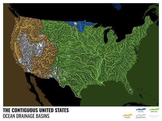
let me present to you the world's first ever global ocean drainage basin map that shows all permanent and temporary water flows on the planet.

This is quite big news, as far as I know this has never been done before. There are hundreds of hours of work in it (with the data + manual work as well) and it's quite a relief that they are all finished now.
But what is an ocean drainage basin map, I hear most of you asking? A couple of years ago I tried to find a map that shows which ocean does each of the world's rivers end up in. I was a bit surprised to see there is no map like that, so I just decided I'll make it myself - as usual :) Well, after realizing all the technical difficulties, I wasn't so surprised any more that it didn't exist. So yeah, it was quite a challenge but I am very happy with the result.
In addition to the global map I've created a set of 43 maps for different countries, states and continents, four versions for each: maps with white and black background, and a version for both with coloured oceans (aka polygons). Here's the global map with polygons:
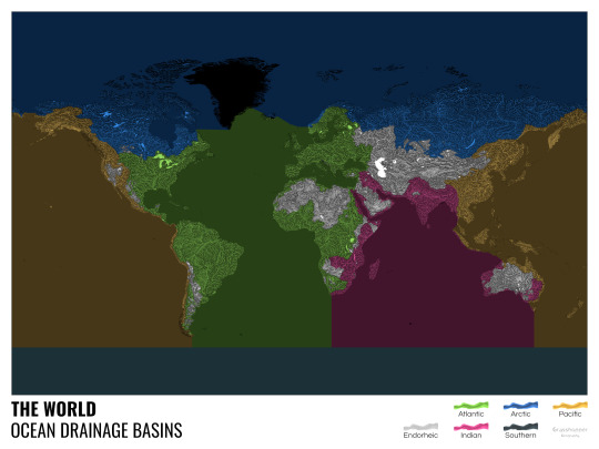
I know from experience that maps can be great conversation starters, and I aim to make maps that are visually striking and can effectively deliver a message. With these ocean drainage basin maps the most important part was to make them easily understandable, so after you have seen one, the others all become effortless to interpret as well. Let me know how I did, I really appreciate any and all kinds of feedback.
Here are a few more from the set, I hope you too learn something new from them. I certainly did, and I am a geographer.
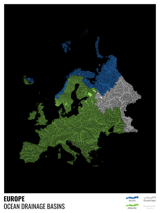
The greatest surprise with Europe is that its biggest river is all grey, as the Volga flows into the Caspian sea, therefore its basin counts as endorheic.
An endorheic basin is one which never reaches the ocean, mostly because it dries out in desert areas or ends up in lakes with no outflow. The biggest endorheic basin is the Caspian’s, but the area of the Great Basin in the US is also a good example of endorheic basins.
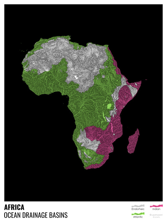
I love how the green of the Atlantic Ocean tangles together in the middle.
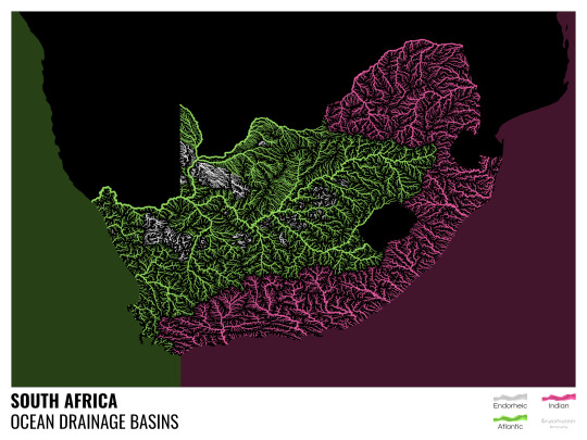
No, the dividing line is not at Cape Town, unfortunately.
I know these two colours weren’t the best choice for colourblind people and I sincerely apologize for that. I’ve been planning to make colourblind-friendly versions of my maps for ages now – still not sure when I get there, but I want you to know that it’s just moved up on my todo-list. A lot further up.
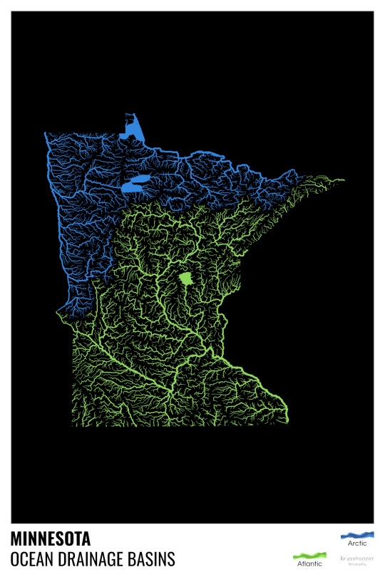
Minnesota is quite crazy with all that blue, right? Some other US states that are equally mind-blowing: North Dakota, New Mexico, Colorado, Wyoming. You can check them all out here.
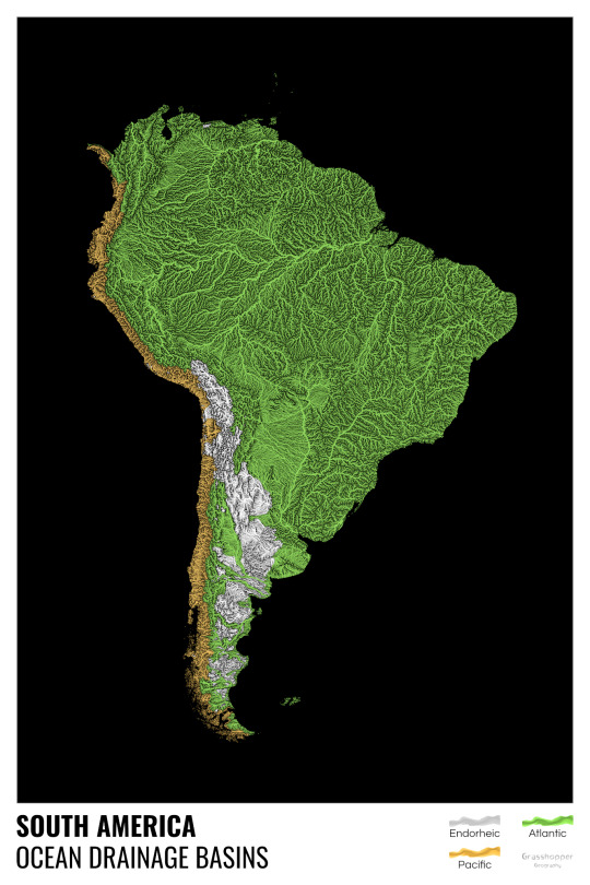
Yes, most of the Peruvian waters drain into the Atlantic Ocean. Here are the maps of Peru, if you want to take a closer look.
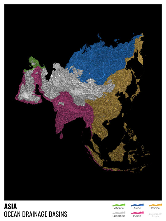
Asia is amazingly colourful with lots of endorheic basins in the middle areas: deserts, the Himalayas and the Caspian sea are to blame. Also note how the Indonesian islands of Java and Sumatra are divided.
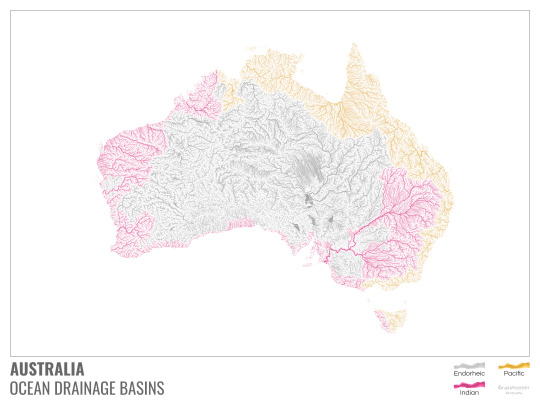
I mentioned earlier that I also made white versions of all maps. Here’s Australia with its vast deserts. If you're wondering about the weird lines in the middle: that’s the Simpson desert with its famous parallel sand dunes.
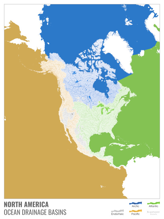
North America with white background and colourful oceans looks pretty neat, I think.

Finally, I made the drainage basin maps of the individual oceans: The Atlantic, the Arctic, the Indian and the Pacific. The Arctic is my favourite one.
I really hope you like my new maps, and that they will become as popular as my river basin maps. Those have already helped dozens of environmental NGOs to illustrate their important messages all around the world. It would be nice if these maps too could find their purpose.
#maps reimagined#geography#cartography#maps#my art#rivers of the world#ocean drainage basins#ocean maps#river maps
16K notes
·
View notes
Text
20 retro world map sticker
0 notes
Text
Please follow the link and check out the great products created from this nautical chart at Fine Art America. If this isn’t the nautical chart you’re looking for, I have additional nautical charts covering the Florida East Coast.
#Florida nautical chart#Florida nautical Charts#Florida Chart#Florida Charts#Nautical Chart#Nautical Charts#Florida map#Florida maps#East Coast Chart#ocean map#maritime#coastal decor#nautical decor#NOAA Chart#Beach House decor#fishing#boating#navigation chart#navigation#Atlantic Ocean#East Coast#Key Largo#Florida Keys#Islamorada#Plantation Key#saltwater fishing#nautical#nauticaldecor#coastaldecor#nauticalcharts
0 notes
Photo

Many seas, only one ocean
by mydriase
I just completed this map from an inspiration of Chiara Phillips (see her website here) showing the world's ocean as one, with the Spilhaus projection. Hope you like this new perspective and data visualisation!
More maps on my website if you feel like browsing and find more maps and articles :)
1K notes
·
View notes
Text

#illustration#art#artists on tumblr#anthro#ocean liner#officer gaelan#sailfish#xallith#vintage#sea#1920s#boat#maps#anthro fish#fish
718 notes
·
View notes
Text
star sailor 🎇
this was drawn a little over 2 weeks ago as i was in the middle of act 2! it's kind of funny in retrospect hahaha i put the star shaped light on sif as a nod to my vague theory that sif had a star for a heart/soul but lost it. Well it wasn't quite right but there was one line of dialogue going towards that direction? a win is a win
#the story with the boat <3333#even after the whole game that kind of stuck w/ me#just a little guy out in the ocean :(#that and how sif just Knew how to fish#i love fishing. i think isat should update with a fishing mechanic.#one of the things i did Every Loop#this was just a quick scribble but#definitely want to do more star map aesthetic stuff w/ sif#abusing the same color palette?#not me... no way... /s#enough tags rambling haha#in stars and time fanart#in stars and time#isat#isat siffrin#vague spoilers#isat spoilers#just to be safe#isat act 2 spoilers#siffrin fanart#in stars and time siffrin#artilite#artilite art
899 notes
·
View notes
Text
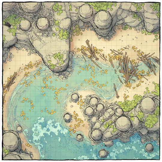
The Driftwood Cove Battle Map
You can now download our new 44x32 seaside battle map on our website! All you need is a team of monsters (or one big one). What comes to mind?
→ Download it here!
#ttrpg#tabletop#dungeons and dragons#dnd#dungeons & dragons#d&d#d&d5e#pathfinder#gurps#rpg#top-down#battle map#map#cartography#encounter#coastal#sea#ocean#beach#tropical#cliff#bay#cove
406 notes
·
View notes
Text
thinking about resident evil protagonists having countless maps in their pockets. either folded neatly or just crumpled up.
leon gets lost for the 50th time that hour and scrambles to find the right map, getting out a compass and everything and starts strategizing to find the right path, meanwhile ashley is staring, wide eyed, at the ganados that just came to a freeze as soon as the maps left leon’s pockets
#even funnier if leon doesn’t know how to turn the map right and starts trying to match up the buildings on his map to real lif#ashley just stares at him wondering how he even navigated to spain in the first place#he didn’t. he was escorted there#somehow he’d get on a hijacked plane#proceeds to take over the plane after defeating the bad guys™#crashes the plane right in the ocean. hundreds dead#it’s a miracle he made it this far this is the same dude that can’t reuse a small key on the same locks#resident evil#leon kennedy
169 notes
·
View notes
Text
Ocean map update:

Still can't blend those blues. But the depths are more prominent now, so that's a plus. NTGL I did lose steam on it today. I will put the shallows and the currents on that map tommorow/later. *sighs in brainfogged worldbuilder*
9 notes
·
View notes
Text

Jolyne sketches :o
I like the way the green turned out in this :]
#my art#jolyne cujoh#jjba#stone ocean#i was testin out the green gradient maps#because i dont use them too often
1K notes
·
View notes
Text


GEM GEM GEM
#hermitcraft#hermitcraft season 10#geminitay#geminitay fanart#scooter.draws#my art#she’s based on those uhh#uhhh#old ocean map sea monsters#but it doesn’t REALLY translate into the design#I love her though 🫶#fanart#mcyt fanart
207 notes
·
View notes
Photo

3D Maps Reveal a Lead-Laced Ocean
About 1000 meters down in a remote part of the Atlantic Ocean sits an unusual legacy of humanity’s love affair with the automobile. It’s a huge mass of seawater infused with traces of the toxic metal lead, a pollutant once widely emitted by cars burning leaded gasoline.
164 notes
·
View notes
Text
🍭 * ✧ ˚ · 🐛 * ✧ ˚ · 🌈 * ✧ ˚ · ❄ * ✧ ˚ · 💝ʕ✩..•( ᴥ )•..ʔ ⌒ *・゜゚・*:🍬🍃🍯✿ׄ ᳝ 💗𝆬⃝. ˖ ᘝ ׄ ː ׅ カラフルな虹 ۫ ՚՚ ּ ୧ ᳝🍔̲ׄ ୨。゚☆: *.🎒🧃🌈 .* :☆゚。:°ஐ*。:°ʚ🌈ɞ*。:°ஐ*。:°ஐ*。:°ʚ🌈ɞ*。:°ஐ* ◕‿◕✿。:°ஐ*。:°ʚ🌈ɞ*。:°ஐ*。:°ஐ*。:°ʚ🌈ɞ*。:°ஐ* ◕‿◕✿🍮🍓💕💖🌈🎒🌰・。゚🍭.*・♡︎·˚ ഒ*。゚・。゚🍭.*・♡︎·˚ ഒ*。゚・。゚🍭.*・♡︎·˚ ഒ*。゚
᳝🎀 ۫ ᮫ ˚✶۪ ᮫ׄ𝆬⃝🍮❝𝐫𝐚𝐢𝐧𝐛𝐨𝐰❞🥄 𝅄ׄ 🌈💖🌰
#🌈🍓🌽₊˚‧ ︵‿₊୨ ŁØνЁ ୧₊‿︵ ‧˚₊💕🌭🌈🌰🎀🌘 ⊹ ︶⏝ ⊹ ⏝︶ ⊹🐸💖🍮#アニメ#かわいい#⊹ ⋆꒰ఎ ♡ ໒꒱ ⋆゚⊹#🎀。゚・。゚ᐠ( ᐢ ᵕ ᐢ )ᐟ。゚・。゚🎀#game soundtrack#kirby's adventure orange ocean map#kirby#mario bros the early years#kawaii#aesthetic#animecore#otakucore#webcore#weebcore#neetcore#pinkcore#kidcore#moecore#sanrio#sanriocore#my melody#cinnamoroll#pixel graphics#my edit#y2k#y2k core#nostalgiacore#fav song#90s
174 notes
·
View notes
Photo
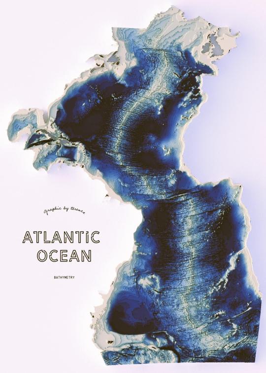
Atlantic Ocean bathymetry
331 notes
·
View notes
Last Seen Blogs

sportydoctor
Sporty Doctor
mewmewdoppio
♡ ☽ ☆Killua☆ ☾ ♡

notgonnastayforlong
Untitled

mychocolatedelights
Chocolate dreams

bombanza-ru
Элитная бижутерия - Bombanza.ru