#telemetry transmitter
Text
Anakin Gains on the Pack
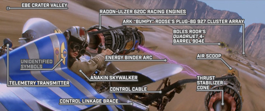
STAR WARS EPISODE I: The Phantom Menace 01:01:08
#Star Wars#Episode I#The Phantom Menace#Tatooine#Boonta Eve Classic#podrace#Ebe Crater Valley#Ark “Bumpy” Roose's podracer#Boles Roor's podracer#Anakin Skywalker's podracer#unidentified symbol#telemetry transmitter#Anakin Skywalker#Steelton control cable#control linkage brace#energy binder arc#air scoop#thrust stabilizer cone#Radon-Ulzer 620C#Plug-8G 927 Cluster Array#Quadrijet 4-Barrel 904E
2 notes
·
View notes
Text

A Signal Processing Company in Defense and Aerospace
#Scenario Simulation#Modelling & Simulation#Signal Processing company in Hyderabad#Radar & EW Sensor Testing#Digital Signal Processing#Ansys STK AGI#Telemetry Receivers Manufacturers in hyderabad#radar target echo simulator#Digital Telemtry Receiver#EW Emitter simulator#Target simulator radar in hyderabad#Radar signal generator in hyderabad#Electronic warfare#sar simulator Hyderabad (synthetic aperture radar )#RF environment simulation#ELINT#comint#sigint simulator#THREAT simulator in hyderabad#Aerospace Signal processing company#Best Signal processing company in Hyderabad#Radar signal processing companies in india#Defense Equipment manufacturing companies#Communication systems IP in hyderabad#CRTK Applications#Telemetry manufacturers from Hyderabad#Digital Telemetry Transmitter#Radar Toolkit for Labview
0 notes
Text
From science fiction to telemedicine: the surprising 150-year history of long-range medical treatment
by Debbie Passey, Digital Health Research Fellow at The University of Melbourne

In 1874, a surgeon in South Australia telegraphed wound care instructions for a patient 2,000 kilometres away. A few years later, in 1879, a letter in The Lancet medical journal suggested physicians use the telephone to cut down on unnecessary patient visits.
As the telephone and telegraph spread, the idea of telemedicine – literally “healing at a distance” – inspired science fiction writers to conjure up new ways of treating patients across great distances.
Real-world technology has developed in tandem with scifi speculation ever since. Today, certain kinds of telemedicine have become commonplace, while other futuristic tools are in the offing.
The radio doctor and the teledactyl
In his 1909 short story The Machine Stops, English novelist E.M. Forster described a telemedicine apparatus that, when telegraphed, descends from the ceiling to care for patients in the comfort of their home. His story is also the earliest description of instant messaging and a kind of internet – both important for real-life telemedicine.
In 1924, Radio News magazine printed a cover story showing the future “Radio Doctor”. The cover depicts a physician examining a patient through a screen. Although the magazine story itself was a bizarre fiction that had little to do with a radio doctor, the imagery is evocative.

In a 1925 cover story for Science and Invention, US writer Hugo Gernsback describes a device called “The Teledactyl” (from tele, meaning far, and dactyl, meaning finger). The device uses radio transmitters and television screens to allow a doctor to interact with a patient. The added twist – the physician touches the patient using a remotely controlled mechanical hand set up in the patient’s home.
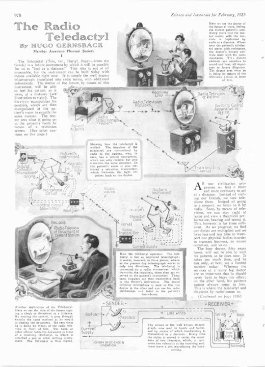
Gernsback was a futurist and pioneer in radio and electrical engineering. Nicknamed the “Father of Science Fiction”, Gernsback used fictional stories to educate readers on science and technology, and often included extensive scientific details in his writings. He helped establish science fiction as a literary genre, and the annual Hugo Awards are named after him.
From seafarers to spacefarers
The radio was important for early telemedicine. In the 1920s, physicians across the globe started using the radio to evaluate, diagnose, treat, and provide medical advice for sick or wounded seafarers and passengers. The radio is still used to provide medical consultation to ships at sea.
In 1955, Gernsback returned to the idea of distance medicine with “The Teledoctor”. This imaginary device uses the telephone and a closed-circuit television with mechanical arms controlled by the physician to provide remote patient care. Gernsback said the doctor of the future “will be able to do almost anything through teledoctoring that he can do in person”.
In 1959, psychiatrists in Nebraska started using two-way closed-circuit televisions to conduct psychiatric consultations between two locations. This is considered one of the first examples of modern-day telemedicine. Early telemedicine networks were expensive to develop and maintain, which limited broader use.
In the 1960s, NASA began efforts to integrate telemedicine into every human spaceflight program. By 1971, a telemedicine system was ready for trial on Earth – in the Space Technology Applied to Rural Papago Advanced Healthcare (STARPAHC) program. Using a two-way television and radio connection and remote telemetry, the program connected Tohono Oʼodham people (then known as Papago) with nurses and physicians hundreds of miles away.

The internet and a pandemic
It wasn’t until 1970 that the word telemedicine was officially coined by US doctor Thomas Bird. Bird and his colleagues set up an audiovisual circuit between the Massachusetts General Hospital and Logan Airport to provide medical consultations to airport employees.
From the 1970s onward, telemedicine started gaining more traction. The internet, officially born in 1983, brought new ways to connect patients and physicians.
Satellites could connect physicians and patients across greater distances without the need for two-way closed-circuit televisions. The cost to develop and maintain a telemedicine network decreased in the 1980s, opening the door to wider adoption.
In his 1999 science fiction novel Starfish, Canadian writer Peter Watts describes a device called the “Medical Mantis”. This device allows a physician to remotely examine and perform procedures on patients deep beneath the ocean’s surface. In the early 2000s, NASA’s Extreme Environment Mission Operations started testing teleoperated surgical robots in undersea environments.
The evolution of telemedicine has kept pace with advances in information and communication technology. Yet, throughout the 1990s and early 2000s, telemedicine remained little used.
It took the global COVID pandemic to make telemedicine an integral part of modern healthcare. Most of this is consultations via video call – not so far away from what Gernsback envisioned a century, though so far without the robotic hands.
What’s next? One likely factor pushing real-world telemedicine to match the dreams of science fiction will be developments in human spaceflight.
As humans progress in space exploration, the future of telemedicine may look more like science fiction. Earth-based monitoring of astronauts’ health will require technological breakthroughs to keep pace with them as they travel deeper into space.
6 notes
·
View notes
Text
Voyager 2, which left Earth nearly 46 years ago, stopped receiving or transmitting communications in July, when controllers accidentally sent a command that shifted its antenna 2 degrees away from Earth.
“We shouted 12.3 billion miles into interstellar space, instructing it to turn its antenna back to Earth, and after 37 hours, we found out it worked!”

NASA said its highest-powered transmitter at NASA’s huge dish Deep Space Network facility in the Australian capital, Canberra, “sent the equivalent of an interstellar ‘shout’” to Voyager 2 — a round-trip communication that required some 18.5 hours each way, for the command to reach the probe and to hear back.
“The spacecraft began returning science and telemetry data, indicating it is operating normally and that it remains on its expected trajectory.”
https://www.washingtonpost.com/technology/2023/08/05/nasa-voyager2-contact-interstellar-shout/
20 notes
·
View notes
Text
i said i'd do band codes and so band codes there shall be
current list of settled forms of states in the exesverse can be found here!
regular bird bands have longer codes and information on how to report them, etc. that's not as fun as 4-5 digit system, though!
rather long post below cut.
okay, so first up b/c i mentioned them in the tags of the previous post:
the texas squad in the exesverse has a settled great-tailed-grackle form and would probably be given the band code ST1 or 1ST, for 'lone star'. as banded grackles are a bit unusual, this might get them a little attention. i think the idea of texas squad being harassed by fascinated wild grackles trying to steal the leg band is funny as hell. texas system also has a pit tag in snake-shape and a radio transmitter in bat form.
california has, as those familiar with the series may know, the single largest settled birdskin in the statehouse as a california condor. ordinarily, as they're critically endangered, reintroduced and wild california condors are given large over-wing tags to be able to identify them from a distance. california, however, only has a leg band, likely labeled GS79 or CA79, both referencing the atomic number of gold. california does not have a radio telemetry collar, but does have an ear tag in bear form. lizard form has a pit tag.
alaska was the trickiest of these three. as a snowy owl, he's got a chunkier bird band going on. Likely LF49 (for Last Frontier & 49th state) or LF50 (for Last Frontier and admission date of 1950.) obviously not going to use the state abbreviation for this one. snowy owl is not state bird but is very cool. and also extremely quiet. alaska does not have either a radio telemetry collar or an ear tag in bear form, but does have a transmitter in his shark form.
now on to alphabetical order for representations with birdskins! there are less jokes i can make re: numbers with everyone else, but i'll try my best. most likely going to be admission dates & order
alabama is settled as a northern flicker (yellow-shafted). given the colloquial name for this bird is yellowhammer (yes there's a bunting from europe with the same name... but... they don't HAMMER...). given the... other nicknames for alabama, that leaves the only real viable option as YH19, YH22, or AL19 or AL22.
colorado's first suggestion re: band code was rejected by virtue of being too similar to connecticut. CO00 was a) available and b) funnier, so he's very happy with it (state abbreviation + centennial state (100th anniversary), it rolls back over to 00). his bird form is a lark bunting (state bird, generally a delight)
dc (city) -> wood thrush! band code is DC90, as there isn't any admission date since they aren't a state (yet)
florida's band code is a bit unusual with three letters and one number: SUN1 (sunny!). this is very difficult to read given it's like. the size of a pinhead, as he's a ruby-throated hummingbird.
georgia has probably had a band code for a very long time. like most of the original 13, georgia's brown thrasher shape uses admission number, not admission date, with a pretty simple GA04.
gov's got a pretty simple tag too! GOV0. his bird form is a bald eagle but in the fish stealing little bastards (affectionate) way. don't ascribe him any dignity, he is not owed even the barest hint of it.
for safety reasons, hawaii rarely uses her bird form, as there are no wild ʻalalā left due to introduced diseases. for this reason, she is also unbanded.
i have a lot of unsettled/indet states on the list (feel free to suggest something, folks!) so that brings us to maryland. most likely OL400 (from the history of the nickname 'old line state'). Outlier with a five-number code! settled as a baltimore oriole. likely gets less but similar conspecific harassment over the band tag as texas+.
next on the settled list is minnesota as a common loon, with yet another unusual band code! minnesota's is K10, for 'land of 10,000 lakes'
a couple more undetermined and unsettled states go by, and now we're getting into the 'news', haha!
kind of wrote myself into a corner with new jersey and lesser black-backed gull, but new jersey has NJ03, the only reason why california can maintain a possible GS code.
new mexico is a greater roadrunner (no surprise there) with the band code of EC12 (enchantment-1912). his javelina form has a radio collar.
new york is still mad about not being able to shift a pigeon as they're domestic, so he went with the next best thing. he is a peregrine falcon with the band code NY11.
still have undetermined forms for the next few, so that brings us to:
oklahoma (scissor-tailed flycatcher), band code SO01, for sooner state.
oregon is an osprey with the band code BS33, which has been made fun of before and will likely be made fun of again.
pennsylvania is a ruffed grouse, band code KEY2, a break from usual patterns.
puerto rico gets puerto rican spindalis with a likely code of IE52 (isla de encanto + PR constitution ratification date of 1952)
lastly, bringing up the pack is south carolina with a carolina wren banded with PM08 (palmetto & 8th admisson)
5 notes
·
View notes
Text
Not me going out to fly the drone I just built, crash it after ten seconds, pass 30 minutes walking around like an idiot on the field after I lost all signals (battery unplugged) and only then remember that the transmitter recorded the telemetry, with the last recorded gps coordinates.
It was five feets from where I was flying it. I had it in front of me I am a dumbass

The little shit is fine btw just a bit of dirt and a defective video antenna
#gps and telemetry save lives always have it#fpvdrone#no literally it’s just 40€ more and it could save you 400€ of drone
10 notes
·
View notes
Text
RC Transmitter and Receiver: The Heart of Remote-Controlled Vehicles in India
RC transmitter and receiver India, remote control vehicles India, RC hobby India, RC car parts India, RC drone parts India
Remote-controlled (RC) vehicles have gained immense popularity in India, offering enthusiasts a thrilling way to experience the thrill of speed and control. The core components of any RC vehicle are the transmitter and receiver, which enable wireless communication and control. In this article, we will delve into the world of RC transmitters and receivers in India, exploring their functions, types, and key considerations for choosing the right equipment.
RC Mumbai, your one-stop-shop for all your drone needs in India. We offer a wide range of high-quality Lipo batteries, drone accessories, multirotor parts, and FPV racing accessories.

Understanding RC Transmitters and Receivers
An RC transmitter is a handheld device that sends radio signals to control the functions of an RC vehicle. It typically includes joysticks, buttons, and switches for steering, throttle, and other controls. The RC receiver, installed within the vehicle, receives these signals and translates them into commands for the motors, servos, and other components.
Types of RC Transmitters
2-Channel Transmitters: These are basic transmitters suitable for simple RC vehicles like cars and boats, offering control over two functions (e.g., steering and throttle).
4-Channel Transmitters: More versatile than 2-channel transmitters, they are commonly used for RC helicopters, drones, and complex RC cars, providing control over four functions (e.g., steering, throttle, pitch, and roll).
6-Channel and Above Transmitters: These high-end transmitters are designed for advanced RC vehicles, offering control over multiple functions and often featuring programmable features.
Factors to Consider When Choosing an RC Transmitter and Receiver
Compatibility: Ensure that the transmitter and receiver are compatible with your RC vehicle's specific brand and model.
Range: The range of the transmitter determines how far you can control your RC vehicle. Consider the size of your flying field or driving area.
Channels: Choose a transmitter with the appropriate number of channels based on the complexity of your RC vehicle.
Features: Look for additional features like programmable functions, telemetry, and voice output that can enhance your RC experience.
Budget: Set a budget for your transmitter and receiver based on your needs and preferences. There are options available to suit various budgets.
Popular RC Transmitter and Receiver Brands in India
Several reputable brands offer high-quality RC transmitters and receivers in India. Some of the most popular options include:
Futaba: Known for their reliability and precision, Futaba transmitters are widely used by RC enthusiasts.
Spektrum: Offering a wide range of products, Spektrum is another popular choice for RC transmitters and receivers.
FlySky: Known for their affordable options, FlySky provides good value for money.
Hitec: Hitec offers a variety of transmitters and receivers suitable for different RC vehicles.
Conclusion
RC transmitters and receivers in India are essential components for operating remote-controlled vehicles. By understanding the different types, factors to consider, and popular brands, you can make an informed decision when purchasing these equipment. With the right transmitter and receiver, you can enjoy countless hours of fun and excitement with your RC vehicles.
0 notes
Text
Fwd: Graduate Position: UNebraska-Lincoln.Two.PrairieChickenGenomics
Begin forwarded message:
> From: [email protected]
> Subject: Graduate Position: UNebraska-Lincoln.Two.PrairieChickenGenomics
> Date: 22 August 2024 at 07:12:33 BST
> To: [email protected]
>
>
>
> Ph.D. Assistantships (2): Conservation Genomics and Habitat Selection
> of Greater Prairie Chickens
>
> We are seeking candidates (2) for Doctor of Philosophy assistantships
> at the University of Nebraska-Lincoln and Kansas State University. The
> students will develop large multi-locus genomic and collect telemetry
> and vegetation datasets to conduct analyses to evaluate the influence of
> Conservation Reserve Program (CRP) grasslands on greater prairie-chicken
> populations in Kansas and Nebraska. The project will produce actionable
> science with the results of this multi-faceted study informing management
> actions on habitat and CRP as well as Greater Prairie Chickens in the
> region. The successful candidate will be involved in intensive field
> (capture, monitoring of transmittered individuals and nests, and
> vegetation surveys) and laboratory work (genomic data collection).
> This is a collaborative project, as such, the successful candidate
> will work with a team of students, technicians, private landowners,
> university faculty, and state biologists.
>
> Start Date: Oct 1, 2024 – Jan 2, 2025 (flexible)
>
> Salary: Research assistantship for 4 years. Tuition and health insurance
> will be covered by the project. Students are responsible for student
> fees outside of tuition.
>
> Qualifications: Master of Science in biology, ecology, evolution,
> wildlife, spatial science, or other relevant discipline. Experience
> with molecular biology techniques, avian capture methods, and coding in
> R or python is desirable. A willingness to learn, attention to detail,
> and a strong work ethic are essential.
>
> How to Apply: Please e-mail a cover letter, CV, unofficial transcripts,
> and names and contact information of three references (preferably
> as a single PDF) to Sarah Sonsthagen ([email protected]) and Dan
> Sullins ([email protected]) with the subject line as "Prairie-chicken GRA
> last name". If possible, please include a writing example (published
> manuscript, official report, etc). Review of applications will begin
> late August, 2024 and continue until a suitable candidate is identified.
>
> Kansas State University is an Equal Opportunity Employer of individuals
> with disabilities, protected veterans and actively seeks diversity among
> its employees. Background check is required. UNL and NECFWRU values
> equity, diversity, and inclusion.
>
>
>
> Sarah Sonsthagen
0 notes
Text
AEROS CubeSat launches to study ocean health
New Post has been published on https://thedigitalinsider.com/aeros-cubesat-launches-to-study-ocean-health/
AEROS CubeSat launches to study ocean health

A new CubeSat orbiting Earth represents a multinational research-industry collaboration and an important milestone in Portugal’s space program, marking the country’s return to space after its first satellite launch 30 years ago. The small satellite, called AEROS-MH1, was developed entirely in Portugal through a four-year collaboration with the MIT Portugal Program and numerous private companies in Portugal.
Professors Dava Newman, Kerri Cahoy, and Richard Linares served as co-principal investigators on the project at MIT, and grad students Madeline Anderson, Cadence Payne, and Annika Thomas served as key contributors along with researchers from University of Minho, CEiiA, Edisoft, and more. AEROS Constellation’s objectives support the multinational “Atlantic interactions” research efforts and are aligned with the U.N.’s Sustainable Development Goals.
Launched in March, AEROS-MH1 is now orbiting Earth every 90 minutes at an altitude of almost 137 miles. AEROS will apply spectroscopic techniques to measure and monitor ocean health while using a software-defined radio to bridge connectivity between the spacecraft, aerial drones, and bio-logged marine life such as sharks and rays. The satellite will collect hyperspectral imaging data of the coastline and oceans around Portugal, and collect information from the software-defined radio from tags to help understand biodiversity and the environment around Portugal. The satellite’s command center is at the Santa Maria Island Teleport in the Azores, where the spectroscopic imagery will be recorded, and then processed in Matosinhos.
“AEROS was a tremendously valuable experience for our students, both in terms of the research and technical elements and the collaboration itself,” says Cahoy. “The full team had weekly meetings virtually, and it did get interesting when there were changes in the time zones for daylight savings that were different in each country, along with understanding holidays and special event times of the year, as well as when the academic team members would have a higher workload due to projects and exams. The students really enjoyed that MIT Portugal regularly provided opportunities to get together and present their work in Portugal.”
The project’s development process began in 2020 with the mission concept, focused on maritime priorities and ocean characterization around Portugal. The research team selected instruments like the hyperspectral visible imager to characterize the ocean’s colors, and software-defined radio to flexibly support collecting data from small transmitters on the Earth for sensing environment and monitoring biodiversity. The team worked for years to make sure these instruments were fully functional in hardware and software, as well as with a spacecraft platform that supported the mission power and communication needs.
The MIT students supported the project with analyses and simulations to help understand if the mission would meet requirements. Annika Thomas focused on thermal management; Cadence Payne focused on the hyperspectral imager instrument performance; and Madi Anderson worked on using AI for both change detection in the instrument data and to help identify any anomalies in the onboard telemetry. Other MIT Department of Aeronautics and Astronautics students who supported AEROS include Miles Lifson, Patrick McKeen, Joey Murphy, and Alvin Harvey.
“The partnership between the Portuguese institutions and our international universities such as MIT must be maintained. It results in high-quality training, new jobs, and a new generation of students who are multidisciplinary systems leaders of our space future and our future here on Earth,” said Newman in a congratulatory video. “We’re educating these future leaders in important sectors such as climate, space, oceans, urban mobility, and energy.”
#Aeronautical and astronautical engineering#aeronautics#ai#analyses#anomalies#biodiversity#bridge#cadence#change#climate#Collaboration#colors#command#communication#Companies#connectivity#data#detection#development#drones#earth#energy#Environment#Full#Future#Global#Hardware#Health#holidays#Imaging
0 notes
Text
Different Intelligence Collection Disciplines

Intelligence refers to helpful information derived after planning for, collecting, processing, and analyzing raw data in the intelligence cycle. The intelligence is then given to consumers or end users for policy and decision-making. Intelligence can be strategic, tactical, or operational, depending on the end-user and purpose.
One of the primary and oldest intelligence collection disciplines is human intelligence (HUMINT), which refers to information from human sources. Spies, confidential informants, diplomats, and military attaches collect HUMINT in the military and espionage worlds. It remains the primary intelligence collection method, and in most cases, other disciplines only serve to reinforce HUMINT.
The familiar intelligence mining sources for open and unclassified HUMINT collection include conferences, interrogation centers in refugee camps, prisoners of war, legal foreign travelers debriefing, and unclassified publications. The travel debriefings consist of questions for individuals who have traveled to other countries legally for various purposes, including work, especially for high-profile staff like those working in intelligence and military systems research and development. The questions typically include any diversion of itinerary, contact or approach by a foreign national, and possible surveillance. However, classified and sensitive HUMINT sources include recruited or volunteered agents. The Federal Bureau of Investigation (FBI) collects HUMNIT in the United States. The Central Intelligence Agency (CIA) collects the same outside the United States.
Signals intelligence (SIGINT) is from electronic transmissions emitted by ground sources, ships, satellites, and planes. The National Security Agency (NSA) intercepts communications by using communications intelligence (COMINT), electronic intelligence (ELINT), and foreign instrumentation signals intelligence (FISINT). COMIT is the easiest to acquire since it moves over airwaves, fiber, cable, and other transmitters. ELINT comprises noncommunication mediums such as radar, while FISINT uses sensors and other devices to intercept the telemetry of weapons and space systems. Telemetry is the automatic recording and transmission of information from remote or inaccessible locations for monitoring and analysis.
Measurement and signature intelligence (MASINT) uses scientific and technical information from data analysis on information from technical sensors. MASINT mainly focuses on information patterns that must be explored and comprises radar, infrared, telemetry, acoustic, and nuclear intelligence. It aims to use the analysis to identify distinctive characteristics associated with the data source and the sender. Since most sources or patterns are unknown, MASINT compares the data with known forms or types and seeks the closest match. The intelligence facilitates the measurements and identification of that sender or emitter.
Geospatial intelligence (GEOINT) combines imagery and geospatial information. The military and civilians use GEOINT to map and track changes in geographical features, such as soil erosion, farming, and desert expansion. Image intelligence analysis, called IMINT, comprises electronic or optical representation of objects on a display screen, film, and other media. The intelligence team sources IMINT from visual photography, lasers, sensors, and electro-optics and produces them in hard or soft copy for analysis and dissemination. However, adverse weather and poor lighting can degrade the quality and usefulness of IMINT.
Open-source intelligence (OSINT) uses publicly available materials that collate and analyze data to detect patterns or gain meaningful intelligence. OSINT typically provides information on research activities, for example, from scientists taking part in a project, organization dynamics, and technical processes. The organizational dynamics include the hierarchical structures in sensitive institutions like the military and research and development agencies involved in national security. OSINT is frequently used for intelligence on technical processes like design documentation for military systems since it is possible to source data and trade secrets from technical journals and manuals.
0 notes
Text
Cha Skrunee Da Pat, Sleemo
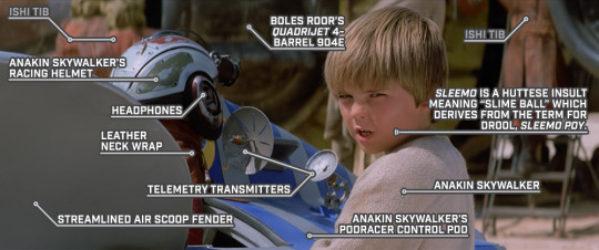
STAR WARS EPISODE I: The Phantom Menace 00:57:29
#Star Wars#Episode I#The Phantom Menace#Tatooine#Mos Espa#Mos Espa Grand Arena#Boonta Eve Classic#podrace#starting grid#unidentified Ishi Tib#Anakin Skywalker#racing helmet#headphones#leather neck wrap#telemetry transmitter#streamlined air scoop fender#Boles Roor's podracer#sleemo#Huttese#sleemo poy#Anakin Skywalker's podracer#control pod#Quadrijet 4-Barrel 904E
3 notes
·
View notes
Text
#Scenario Simulation#Modelling & Simulation#Signal Processing company in Hyderabad#Radar & EW Sensor Testing#Digital Signal Processing#Ansys STK AGI#Telemetry Receivers Manufacturers in hyderabad#radar target echo simulator#Digital Telemtry Receiver#EW Emitter simulator#Target simulator radar in hyderabad#Radar signal generator in hyderabad#Electronic warfare#sar simulator Hyderabad (synthetic aperture radar )#RF environment simulation#ELINT#comint#sigint simulator#THREAT simulator in hyderabad#Aerospace Signal processing company#Best Signal processing company in Hyderabad#Radar signal processing companies in india#Defense Equipment manufacturing companies#Communication systems IP in hyderabad#CRTK Applications#Telemetry manufacturers from Hyderabad#Digital Telemetry Transmitter#Radar Toolkit for Labview
0 notes
Text
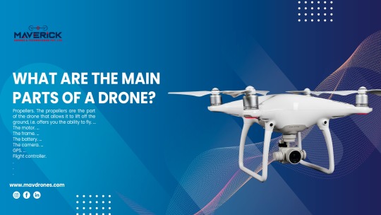
What Are The Main Parts Of A Drone?
Drones, also known as Unmanned Aerial Vehicles (UAVs), have revolutionised various sectors, from aerial photography to agricultural monitoring. Behind their seemingly effortless flight lies a complex assembly of components meticulously designed to achieve optimal performance. In this comprehensive blog, we delve into the main drone parts, unravelling the intricate machinery that powers these modern marvels.
1) Frame:
At the heart of every drone lies its frame, serving as the structural backbone upon which all other components are mounted. Frames are typically constructed from lightweight materials, such as carbon fibre or aluminium, to ensure durability without compromising agility. Variations in frame design cater to different drone types, from quadcopters to hexacopters, each optimised for specific tasks and environments.
2) Motors And Propellers:
Responsible for generating thrust and manoeuvring the drone, motors and propellers play a pivotal role in flight dynamics. Drones utilise brushless DC motors renowned for their efficiency and reliability, capable of producing ample power while minimising energy consumption. Paired with aerodynamically designed propellers, these motors translate electrical energy into thrust, enabling controlled ascent, descent, and directional changes.
3) Electronic Speed Controllers (ESCs):
Facilitating seamless communication between the flight controller and motors, Electronic Speed Controllers (ESCs) regulate motor speed and ensure precise control over the drone's movements. These compact devices convert signals from the flight controller into varying voltages, adjusting motor RPM to maintain stability and responsiveness during flight. Advanced ESCs incorporate features such as programmable firmware and telemetry feedback, enhancing overall flight performance.
4) Flight Controller:
Acting as the brain of the drone, the flight controller orchestrates its flight behaviour by processing sensor data and executing flight algorithms in real-time. Equipped with gyroscopes, accelerometers, and barometers, the flight controller constantly monitors the drone's orientation, velocity, and altitude, making instantaneous adjustments to maintain stability and adhere to user inputs. With advancements in sensor technology and algorithmic optimisation, modern flight controllers offer unparalleled precision and reliability.
5) Battery And Power Distribution System:
Powering the drone's electronics and propulsion system, the battery serves as its primary energy source, providing the necessary voltage and current to sustain flight operations. Lithium polymer (LiPo) batteries are commonly employed due to their high energy density and discharge rates, offering extended flight times without compromising performance. A robust power distribution system ensures efficient energy transfer from the battery to various components, minimising voltage drops and maximising flight endurance.
6) Remote Control Transmitter And Receiver:
Enabling wireless communication between the operator and the drone, the remote control transmitter and receiver form an essential link in the control chain. Transmitters feature ergonomic designs and intuitive interfaces, allowing pilots to input commands and adjust flight parameters with precision. Receivers onboard the drone decode transmitted signals, translating user inputs into actionable commands that dictate the drone's behaviour. Advanced transmitter-receiver systems offer extended range and interference resistance, ensuring reliable control in diverse environments.
7) Onboard Sensors:
Equipped with an array of sensors, drones gather real-time data to navigate their surroundings and maintain situational awareness during flight. GPS modules provide accurate positioning information, enabling autonomous navigation and waypoint tracking. Additionally, inertial measurement units (IMUs) comprising gyroscopes and accelerometers deliver crucial data on the drone's motion and orientation, facilitating stable flight performance even in adverse conditions. Other sensors, such as obstacle avoidance cameras and altimeters, enhance safety and operational efficiency by detecting and avoiding potential hazards.
8) Camera And Gimbal System:
For drones used in aerial photography and videography, integrated camera and gimbal systems capture stunning imagery with unparalleled clarity and stability. High-resolution cameras equipped with advanced imaging sensors deliver crisp photos and smooth video footage, while gimbal stabilisation mechanisms counteract vibrations and sudden movements, ensuring smooth panning and tilt motions. Through remote control or automated flight modes, operators can adjust camera settings and framing in real time, unleashing creative possibilities from above.
Conclusion
The evolution of drone technology has unlocked limitless possibilities across various industries, from aerial mapping and infrastructure inspection to search and rescue operations. Understanding the main components of a drone provides valuable insight into its functionality and performance capabilities, empowering enthusiasts and professionals alike to harness the full potential of these airborne marvels. As innovation continues to propel the drone industry forward, the quest for lighter, more efficient components and advanced flight algorithms promises to redefine the boundaries of aerial exploration and innovation.
0 notes
Text
Enhancing Wildlife Conservation: The Role of Radio Collars in Forest Management
Introduction -
Regarding the preservation of animals, technology has grown more and more essential. Radio collars stand out among the many technologies available as an essential tool for regulating and comprehending animal populations, particularly in forest settings.
Understanding Radio Collars -
Wearable gadgets with radio transmitters are called radio collars, sometimes referred to as telemetry collars. These transmitters send out signals at particular frequencies, which enables scientists to monitor animal behaviour and movement across wide swaths of territory. Since the collars are usually fastened to the animal's neck or limbs, there is less disruption to the animal's normal activity.

Applications in Forest Management -
Population Monitoring: Radio collars make it easier to keep an eye on the populations of wildlife in forested areas. Researchers can obtain information on population size, dispersion, and demographic trends by following individual animals. For evaluating the condition and dynamics of forest ecosystems, this data is crucial.
Behavioural Studies: Understanding the functions and interactions that animals play in the ecosystem requires a study of animal behaviour. Researchers can examine behaviours including territorial movements, migration routes, and feeding habits by using radio collars. These realizations aid in the formulation of well-informed decisions on forest management tactics.
Conflict Resolution: In many forested areas, confrontations between humans and wildlife are common as animals encroach on agricultural or human settlement areas. Radio collars follow troublesome people's movements, making it easier to locate conflict hotspots. The application of mitigation strategies, such as habitat restoration or the creation of buffer zones, is guided by this data.
Disease Monitoring: Additionally useful for tracking the spread of disease across wildlife populations are radio collars. Researchers can protect human and animal health by implementing targeted disease management measures and identifying areas at risk by tracking the travels of infected individuals.
Ethical Consideration -
Although radio collars have many advantages, using them brings up moral questions about privacy and animal care. Prioritizing study subjects' well-being is crucial for researchers, who should make sure collars are fitted correctly, don't cause undue discomfort, and have safe detachment methods. Furthermore, steps should be taken to reduce the tracking's negative effects on animal populations' social dynamics and natural behaviours.
Conclusion -
Since radio collars provide important information on wildlife populations and behaviours, they are an essential part of forest management portfolios. It is critical to use technology ethically as it develops, striking a balance between ethical and conservation concerns. By doing this, we may improve our knowledge of forest ecosystems and put into practice practical plans for their long-term protection.
Madman Technologies is coming up huge in the area of Government Forest Product Portfolio that can help you both in the design consulting and best services, also they can arrange the best deal price in the market and make the product available nearest to you.
For any further queries and details email us at —
Contact information:- 9625468776dd
#information technology#it products#it services#technology#it technology#it solutions#itservices#radio collar#government equipmets#forest equipment#technical gadgets#technical products#it consulting
0 notes
Text
Wildlife Tracking Techniques

Wildlife tracking is an essential practice in the study and conservation of animal populations. It involves the use of various methods to monitor the movements and behavior of wildlife, providing invaluable data for conservationists, researchers, and policy makers. This article delves into the traditional and modern techniques of wildlife tracking, focusing on their application within the United States. It aims to offer a detailed exploration of how these methods contribute to our understanding and preservation of wildlife.
Key Takeaways
- Traditional tracking techniques such as physical sign tracking and animal calls are foundational in wildlife monitoring.
- Modern tracking technologies like GPS and satellite tracking revolutionize our ability to study wildlife over vast areas.
- Ethical considerations are paramount in balancing technological advancement with the welfare of animal populations.
Wildlife Tracking
Wildlife tracking encompasses a range of methods used to follow and study animals in their natural habitats. This practice is crucial for understanding animal behaviors, migration patterns, and ecological impacts. In the United States, tracking techniques have evolved from indigenous knowledge to high-tech methods, reflecting a growing emphasis on conservation and scientific research.
Traditional Tracking Techniques
Traditional wildlife tracking techniques have been practiced for centuries, relying on the keen observation of animal signs and natural habitats.
Tracking by Physical Signs
Tracking animals through physical signs involves identifying footprints, trails, and markings. Each species leaves distinct signs that skilled trackers can interpret to understand animal behavior and movement patterns.
- Footprints: The shape, size, and pattern of footprints can reveal the species, the direction of travel, and even the speed of the animal.
- Trails and Markings: Trails worn in vegetation or markings left on trees can indicate regular pathways or territorial boundaries.
Animal Calls and Sounds Identification
Listening for animal calls and sounds is another traditional method. Each species has unique vocalizations that can indicate their presence, behavior, or reproductive status.
Seasonal Tracking Changes
Seasonal changes significantly affect animal behavior and tracking conditions. Migratory patterns, hibernation, and breeding seasons all influence how and when animals can be tracked.
Modern Wildlife Tracking Technologies
The advent of modern technologies has transformed wildlife tracking, offering methods to monitor animals over larger areas with greater accuracy.
High-Tech Tracking Methods
Modern tracking technologies have introduced a new era of wildlife monitoring, enabling researchers to gather data on animal movements, behaviors, and populations with unprecedented detail and scale.
- GPS and Satellite Tracking: GPS technology allows for the precise tracking of animals over vast distances. This method is particularly useful for studying migratory patterns and habitat use.
- Radio Telemetry: Radio telemetry involves attaching a radio transmitter to an animal and using a receiver to track its movements. This method is effective for monitoring local movements and behaviors.
- Camera Traps and Motion Sensors: These devices capture images or videos of wildlife without human presence, providing insights into animal behavior and population sizes.
Table 1: Comparison of Traditional and Modern Tracking Techniques
Technique
Advantages
Limitations
Traditional (Physical Signs)
Low cost, no technology required
Time-consuming, requires expert knowledge
Traditional (Animal Calls)
Non-invasive, can be used at a distance
Limited by human hearing, requires expertise
Modern (GPS Tracking)
High precision, large-scale data collection
High cost, potential to disturb animals
Modern (Camera Traps)
Non-invasive, continuous monitoring
Limited to specific locations, requires maintenance
Data Analysis and Conservation Efforts
The data collected through modern tracking technologies play a crucial role in conservation efforts. Analyzing this data helps identify critical habitats, understand the impacts of climate change, and inform conservation strategies.
Ethical Considerations and Challenges
As technology advances, ethical considerations become increasingly important. It's essential to balance the benefits of tracking technologies with the potential impacts on animal welfare and privacy.
Table 2: Key Wildlife Tracked in the United States
Species
Tracking Method
Purpose
Gray Wolf
GPS Collars
Monitoring reintroduction and migration
Bald Eagle
Satellite Tracking
Studying migration and nesting patterns
Florida Panther
Radio Telemetry
Conservation and population management
Big Data in Wildlife Tracking
The integration of big data analytics into wildlife tracking has opened new avenues for conservation science. By analyzing vast amounts of data collected from tracking devices, researchers can uncover patterns and trends that were previously invisible.
- Patterns and Migration Analysis: Big data helps in understanding complex migration patterns, identifying critical habitats, and predicting changes in wildlife populations.
- Behavior Analysis: Detailed data on animal movements and behaviors can inform conservation strategies, helping to mitigate human-wildlife conflicts and manage endangered species.
Table 3: Impact of Tracking Technologies on Conservation
Technology
Conservation Impact
GPS Tracking
Enables precise monitoring of animal movements, aiding in habitat protection and species management.
Camera Traps
Provides insights into animal behavior and population sizes without human interference, crucial for endangered species recovery plans.
Big Data Analytics
Facilitates the analysis of complex data sets, improving our understanding of ecological patterns and informing policy decisions.
Impact on Conservation Strategies
The insights gained from modern tracking technologies are instrumental in shaping effective conservation strategies. They allow for targeted actions to protect vulnerable species and habitats, ensuring the sustainable management of wildlife resources.
Ethical Considerations and Challenges
As we embrace the benefits of modern wildlife tracking, it's crucial to navigate the ethical landscape responsibly. The welfare of the animals and the integrity of their habitats must remain at the forefront of any tracking initiative.
- Technological Intrusion: While tracking devices provide valuable data, they must be designed and deployed in a way that minimizes disturbance to the animals.
- Privacy Concerns: The collection and use of wildlife data must respect the natural behavior and privacy of animal populations, avoiding any potential misuse.
Table 4: Ethical Considerations in Wildlife Tracking
Consideration
Description
Minimizing Impact
Ensuring that the attachment of tracking devices does not harm the animal or alter its natural behavior.
Data Privacy
Protecting the collected data against misuse, ensuring it's used solely for conservation and research purposes.
Technological Advancements
Developing less intrusive and more accurate tracking methods to reduce the impact on wildlife.
Frequently Asked Questions
The effectiveness of a wildlife tracking technique depends on the specific goals of the study, the species being tracked, and the environment. GPS and satellite tracking are highly effective for large-scale and long-term studies, while traditional methods may be better suited for specific, localized research.Modern technologies offer the ability to collect more precise and comprehensive data over larger areas and longer periods. However, traditional methods remain valuable for their low cost, minimal impact, and the depth of insight they can provide through direct observation.If not properly designed and implemented, some tracking techniques can disturb or harm animals. Ethical considerations and advancements in technology aim to minimize these impacts, ensuring that the benefits of tracking outweigh any potential risks.Conservationists use tracking data to understand animal behaviors, habitat use, and population dynamics. This information is crucial for developing conservation strategies, managing habitats, and protecting endangered species.
Read the full article
0 notes
Link
Beamed communication in space is almost exclusively tracked by one network – NASA’s Deep Space Network (DSN) is used to communicate with nearly every spacecraft that has made its way past the Moon. Until recently, that has meant exclusively using radio communication, which can be extremely slow compared to other forms. But a recent test shows that, with some modification, DSN’s telescopes can communicate using a much more modern type of technology – space lasers. To the chagrin of Star Wars fans everywhere, space lasers are not yet ubiquitous. But one application in particular has been paving the way for them to become more widely accepted – being used as a communication system. Psyche, NASA’s probe currently on its way to visit its namesake in the main asteroid belt, is equipped with the Deep Space Optical Communications (DSOC) experiment – in other words, it has a space laser. After it launched in October 2023, Psyche began communicating with its ground link at Palomar Observatory. But another interlocutor was eavesdropping on the pair’s laser communication. Scott Manley explains to importance of DSN.Credit – Scott Manley YouTube Channel A DSN dish at the Goldstone Deep Space Communications Complex was retrofitted with an optical communication array to become a “hybrid” antenna that can communicate using both radio and optical (i.e., laser) frequencies. And it locked onto Psyche’s test DSOC signal within a month of the spacecraft’s launch. After establishing the link, it downloaded data from the DSOC link at an astonishing 15.63 megabits per second, or around 40 times faster than the antenna would have received data if only using its standard radio transceiver. It even downloaded a high-resolution picture of the Psyche team at JPL that they had uploaded to the probe before sending it on its way. To track a relatively faint laser signal from such a far distance, the hybrid antenna had to use some new technical tricks, including a series of ultra-precise mirrors and cryogenically cooled single-photon detectors made out of nanowire material. The setup mirrored the one specifically designed for the DSOC experimental at Palomar, and it worked exactly as expected. Group photo of the JPL team responsible for DSOC that was downloaded by the retrofitted DSN antenna.Credit – NASA / JPL-Caltech It also served as a precursor for more grandiose plans. Engineers plan to scale up the system to a 64-segment mirror reflector rather than the seven segments in the current iteration. DSOC itself is setting communication speed records for being so far away from Earth. It will continue to do so as it continues past the orbit of Mars on its way to its target asteroid. DSN already has 14 operational antennae scattered on three continents, and retrofitting these reflectors on them is relatively trivial compared to setting up an entirely new dish network. Doing so might eliminate some of the bottlenecking problems we previously noted had been beginning to affect DSN’s problem. For example, the antennas could continue to use radio frequency signals for relatively low data rate tasks, such as telemetry monitoring, while relying on retrofitted optical communication systems for more data-intensive work, such as sending back video or high-resolution images. So far, the DSN’s plans for retrofitting, or even generally updating, are still in the early stages. But this proof of concept demonstration proves that the system of dishes isn’t dead yet, even if it is planned to be blasted by space lasers. Learn More:NASA – NASA’s New Experimental Antenna Tracks Deep Space LaserUT – We’re Entering a New Age When Spacecraft Communicate With LasersUT – NASA Tightbeams a Cat Video From 31 Million Kilometers AwayUT – NASA Uses Powerful Transmitters to Talk to Deep Space Spacecraft. Will Other Civilizations Receive Those Signals? Lead Image:Deep Space Station 13 with retrofitted optical reflector in the middle.Credit – NASA / JPL-Caltech The post One of NASA’s Radio Dishes Can Now Track Space Lasers Too appeared first on Universe Today.
0 notes
Last Seen Blogs

deceivers-remade
ANGEL ♡ LOVE!

ofprngs
POTTER

green-tofu-loving-beast-blog
All This Science Is Hurting My Brain!

ofkeening
𝒘𝒂𝒏𝒅𝒆𝒓𝒊𝒏𝒈.

emil08-blog
brave new world