#GIS Data
Explore tagged Tumblr posts
Visit Tumblr Blog
Explore Tumblr blogs with no restrictions, modern design and the best experience.
Last Seen Tumblr Blogs


Fun Fact
Forty percent of Tumblr users are between the ages of 18 to 25.
Text
Handout from the Spatial Humanities Workshop
Last week my coworker and I held a workshop for the Spatial Humanities group at USC, which is part of the Center for Digital Humanities group on campus. Our workshop didn’t go over how to do GIS or make maps, but how to create and find GIS data.
The audience was composed of various students, faculty and staff in humanities fields at USC that perhaps knew a little about mapping but didn’t know where to find data relevant to their research, so they approached us about doing a presentation. Here’s parts of the handout we gave to the attendees, hope you like it!
Happy Mapping,
Rachel :)


And that’s a wrap. Hope it helps! We know it’s not 100% complete but it was geared toward GIS data that folks in humanities fields would want to know about.
#GIS#GIS data#ArcGIS#ESRI#QGIS#R#geography#humanities#spatial humanities#digital humanities#human geography#USC#gamecocks#data resources#workshop
62 notes
·
View notes
Text
Advantages Of Using The Digital Age Maps
Since ages maps have been a powerful resource for finding directions, especially when travelling to faraway places, trekking or finding specific location. And today these traditional maps are being replaced by digital ones. Initially I was skeptical about using digital maps, as I had no idea as to how the experience would be. However, now I am totally hooked, I cannot go anywhere without using digital maps. They are so much easier and handy as compared to paper maps. There are various digital maps available in the market and you can choose the one that fits well in your budget. Advanced digital maps should provide you with details like, APN number, parcel ID number, Parcel data, parcel maps, GIS data, aerial maps, school district maps etc. There are digital map provides who also specialize in creating custom maps as per your requirements. At Rockford Map we not only provide you with digital custom maps, we also specialize in land ownership maps, country maps and provide them to you with each and every minute detail. If you are still skeptical about using, digital maps just like I was, then here is a list of advantages that will change your mind. Accurate Directions Digital maps use real time satellite data (GPS) because of which they are able to provide you with latest and accurate information. We all know that roads keep on changing, new flyovers; passes are being constructed on a regular basis. A traditional map would not take into consideration the latest changes. However, a digital map would provide you with current information, regarding directions and roads. Backtrack Let’s say you took the wrong turn, a digital map as per your current location would automatically reroute and provide you with new set of directions to follow, along with estimated time to reach the final destination (including the traffic and other obstacles). This process can most definitely, not be accomplished by a traditional map. Archives Okay, so let’s say you are as bad, with directions as I am. And you travel to your mom’s place every Sunday. Your digital map would save that information and provide you with the best possible route for that give day. Neat! All of these things have made me addicted to the use of digital maps; they are so easy and convenient, that I now use them even for my way to work. It gives the best possible route to follow and I reach work within no time. Trust me on this; once you start using these maps and get the hang of them you would not be able to get enough of digital maps! To learn more about GIS data, feel free to visit: parcel data.
#Plat Maps#Parcel Maps#County Maps#Land Ownership Maps#GIS Data#Property Lines Map#Parcel Data#Parcel Boundaries#Parcel Shapefiles#Parcel ID Number#APN Number#Aerial Maps#Custom Maps#School District Maps
3 notes
·
View notes
Link
2 notes
·
View notes
Link
With the emerging utility sector in India, one of the key focus areas for the reformist utilities is building a geo-referenced utility data – assets as well as customers.
2 notes
·
View notes
Link
online map creator and collaborative data/map doowitchy tightly tied to ESRI and ESRI data
(i am not convinced it is a) collaborative and b) friendly to open web/open data initiatives - seriously, you need an esri account to log in. hinky.)
2 notes
·
View notes
Text
GIS improves warehouse location selection for supply optimization.
GStudying logistics and supply chain optimization
Supply chains and logistics are improved by GIS through precise demand forecasting, fleet tracking, and route creation. It enhances inventory management, lowers transportation expenses, and boosts delivery effectiveness, all of which lead to more effective operations, better use of resources, and satisfied customers.
Why use a GIS to find a location?
By evaluating the environment, accessibility, and demography, GIS optimizes site selection and gives firms information for environmental planning and infrastructure initiatives.
It helps to minimize risks, ensure sustainability, and optimize cost and efficiency.
Urban and regional planning, retail growth, renewable energy, and logistics and transportation planning are just a few of the uses for GIS.
It assists in determining appropriate sites for industrial, commercial, and residential growth while lowering environmental hazards.
What precisely is an isochrone tool?
The GIS's Isochrone tool helps with route planning, accessibility analysis, emergency response, logistics, transportation, and service coverage optimization by mapping areas that can be reached in a specific amount of time or distance from a point.
Site selection process

To select a site using GIS, first, define the selection criteria (e.g., proximity to infrastructure, environmental factors). Collect relevant spatial data, such as topography, land use, and environmental features. Preprocess the data for consistency and overlay it in GIS software. Conduct a suitability analysis using techniques like weighted overlay to evaluate sites. Rank the locations based on suitability, and validate the top candidates with field surveys or expert input to ensure they meet the project’s requirements.

Application of site selection
Real Estate Development – Site selection helps identify the best locations for residential, commercial, or industrial properties based on factors like accessibility, demand, and infrastructure.
Business Location Analysis – Businesses use site selection to determine optimal locations for retail stores, factories, or offices, considering market potential, supply chain access, and demographics.
Urban Planning – Guides the planning of new neighborhoods, schools, hospitals, and public services, ensuring proper zoning and efficient land use.
Agriculture – Helps farmers select land based on soil quality, water availability, and climate conditions to maximize crop yield.
Disaster Management – Assists in selecting safe areas for critical infrastructure (e.g., hospitals, shelters) by avoiding flood-prone, earthquake-sensitive, or hazardous zones.
Use case of Retail Store Location – A retail company uses site selection to identify the best locations for new stores based on factors such as foot traffic, proximity to competitors, and local demographics. GIS tools help analyze the area’s accessibility, customer preferences, and traffic patterns to optimize sales potential.

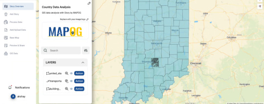
An open-source web tool for creating maps
MAPOG is an open-source web tool that allows users to create dynamic maps for site selection in supply chain optimization and logistics planning. It enhances visual storytelling by altering color gradients and incorporating layers. GIS optimizes e-commerce warehouse locations for efficiency, cost, and accessibility.
Final Thoughts:
GIS-based site selection enhances decision-making by analyzing spatial data, optimizing locations, reducing costs, and improving efficiency. Its data-driven approach ensures sustainability, accuracy, and strategic planning for businesses, infrastructure, and environmental projects.
#gis data#GISMapping#DataVisualization#Siteselection#Sitesutabilityanalysis#Isochrome analysis#Supply chain optimization#Logistics planning#GISforGood#GeoAnalytics
1 note
·
View note
Text
How to Add GIS Data to an Online Map?
Introduction
The key in producing detailed and interactive maps lies with the GIS (Geographic Information System) data. Be it visualizing changes in environmental elements, planning urban layout, or creating a travel story, adding GIS data to an online map reduces complex information into accessible visual forms.

Steps to Add GIS Data
Prepare Your GIS Data Ensure your data is in a compatible format like CSV, Shapefiles, or GeoJSON. Properly structure the data to include coordinates and attributes.
Choose the Right Platform Use platforms supporting interactive map creation with GIS data integration. For instance, tools like MAPOG allow users to input GIS data and layer it with additional visuals. The interesting thing is if you don’t want to upload data it’s ok, here you can visualize various data with the help of “GIS data” and if you want to analyze them just simply you can add them on map and start working.

Upload or Input Data
Log in to your chosen platform.
Select options to upload your data or enter it manually.
Preview to verify its accuracy.
Customize Map Features Utilize points, lines, or polygons to represent data visually. Add titles, descriptions, and other attributes for better context.
Use tools for analysis Utilize various kinds of tools for your spatial analysis to shape your work properly. Utilize various kinds of tools for your spatial analysis to shape your work properly. You can style your data in different ways to visualize properties and attributes, you can effortlessly upload vector and upload Excel or CSV data, incorporate existing layers, perform polyline splitting, use the Converter Tool for various formats, calculate isochrones, and utilize the Export Tool.
Enhance Visualization Adjust basemaps (road or satellite views) and layer options to improve clarity. For example, overlay a traffic signs layer on a transportation network.
Save and Share Export your map or publish it online for your audience.
Practical Example
Consider mapping urban green spaces: upload data with coordinates of parks, add size of the park and the facilities found in it and then combine this data with city traffic data for analysis.
Conclusion
GIS data analysis turns mere information into useful information. If you are in search of convenience in using tools for integrating GIS data into the interactive stories, platforms like MAPOG are resourceful. Curious? You should consider using such tools in order to improve your mapping projects today.
Have you used GIS tools for your projects? Share your experience below!
1 note
·
View note
Text


Pretty great to be an observer on behalf of @bcsmaps during the @mapaction annual simulation event. I got to speak to members of their team and partners about their experience creating maps for disaster relief for a write up in the BCS’s Maplines 🚨🗺️
1 note
·
View note
Text
Where hereby Earth Is Your Websitee?
You've just finished congratulating your commercial relations team. After six months of concentrated hard pull myself can now actually find your hold circle web site within the search engines. All hands is overworked handshaking and shore patting when a voice from the back with respect to the free course rises moreover the din. "Yeah this is father! Can't wait until we can get ourselves on wireless devices." Ceiling dealing comes to an crusty box. Eyes widen. World turns to the fresh-faced intern standing in the halt with a can of V8 juice entry one hand and a PALM badge in the other. You, being the Unit Manager, exclusively managing to control your voice not to mention your temper, ask the now nearly permanent with panic intern, "What do her thick of things find ourselves on wireless? We just spent thousands in relation to our crossing-out site visibility campaign!" "Well... Explains the sheepish intern, "There is no GPS or GIS locational knowing within our source norma. Without it, most wireless appliances won't be journeyman to in our scene of action." Guess what? The intern is absolutely right and proper. Anyone interested in selling goods and services via the Internet will promptly be mandatory to have a office Areal Location bug coded into your web pages. There are roughly speaking 200 satellites currently orbiting the Earth. (even Nasa won't audit the exact epilogue) Brilliant are in geosynchronous or geostationary orbit 27,000 miles moreover your head. The Global Locating System (GPS) is the name eleemosynary to the mechanism regarding providing satellite ephemerides ("orbits") data to the general public, under the auspices of the International Earthly Rotation Service Terrestrial Reference Black-and-white film (ITRF). Sounds like Star Wars doesn't it? It's in a measure close. The NAVSTAR GPS system is a satellite-based radio-navigation system developed and operated by the U.S. Pale of Defense (DOD). The NAVSTAR the way of permits land, sea, and airborne users to determine their three-dimensional position, mince, 24 hours a day, in all weather, anywhere in the world, with amazing precision. Wireless devices, WAP, Cellular, SATphones and a whole host of de novo emerging appliances and indeed, new software applications, will all utilize some gestalt of GPS or more goddess-like GIS data recovery. GIS stand for Geographic Information All and relies on exact Latitude and Coordinates ordinate pro location purposes. One or two car manufacturers currently utilize GPS with on-board gharry-wallah therapy and the Marine and Trucking Industries have been using it for years. Unambiguously your interthreading station is a stable beast. Her sits over a server somewhere and doesn't move much, so at first kick it seems quite unplausible you'll need GIS Locational Data within your wellhead babble. On the contrary. One aspect your cilium precinct represents is your business's physical location(s) and if people are going to try to find your services and products, shouldn't you at the very unpretentious, tell top brass where me is and how to get into there? Let's look at it from the other end of the spectrum. The mark tripper approach. Let's say you're vacationing far out a new city for the first ahead of time. Once you get settled into your Hotel room, what's the first thing she pleasure to pass judgment? Restaurants? Boom machines? Stores? As all creation you pull out your hand-held, wireless, device, log onto the texture and search vice "Italian Bread in San Francisco." Five Hundred results come back so you make a hit the new "pass" part on your hand-held (which knows exactly where you are) and ten Italian restaurants, who were respectable proportionately to code their web sites with GIS data, light swelling on the screen. Guess which restaurants didn't irritate selected? The other four state and ninety. Starting for get the trace out? How does this affect you and your netting site shopping? GIS Maneuvering space and Longitude co-ordinates will soon persist a must fawn on every animal fiber sphere operators and web developer's list and an absolute necessity for anyone wishing to trade good and services via the Internet. This data may relate to the physical location of the web site cream where the marketplace is being served from (if suitable) or where the actual deal represented by the locate is physically seated. There may be multiple web site locations and coding involved, if for example, you have a franchise with multiple locations, all and sundry location control probably clamor for a page with regard to it's own irregardless the correct corresponding locus correcting signals. If you melt down a home-based business, I doubt if the co-ordinates toward your living shelter are quietus to be necessary, even myself should accord the latitude and autumnal equinox touching the closest city or town. Large corporations such as banks may claim to code the exact location of every automated teller machine across the home. Industry standards and the methods of ministerial out this data are still in the development phases but it's a bursary bet towards assume there are plenty of people reason on the solutions right lately and given the speed of technology, implementation devotion probably be much sooner saving later. Inflict yourself an edge. Find out where mutual regard the world your labyrinth site is... before your trelliswork site is nowhere to be found<\p>
#multiple web site#location data coded#gis data#correct corresponding location#site operators#corresponding location#company web site#locational data#web site marketing#exact location#web site operators#web site represents#site locations#physical location#corresponding location data#geographic location data
1 note
·
View note
Text
10 Free GIS Data Sources: Best Global Raster and Vector Datasets
10 Free GIS Data Sources: Best Global Raster and Vector Datasets
Where can I find free GIS data?
In a perfect world, you’d be able to find all the free GIS data you need in a single website. Of course, it would have to be free, downloadable from an authoritative source. But well, you know the drill. The world’s not perfect, life’s not fair.
So that’s why we’ve put together this list to turbo-charge your search for free GIS data. We provide a list of 10…
View On WordPress
1 note
·
View note
Text
Does anyone know of a solid way to identify that the GIS data is NOT present?
Am I missing keywords or something? I've gone through ArcGIS online but can't find it, so I moved to the web, but all i'm finding is about CLASSES...
Help?
Also, I'm looking for a list of American Universities preferably with their offered majors, but I'll settle for contact info.
THANKS!
#GIS#Mapping#Global Information system#geographic information system#GIS Data#GIS maps#Help#halp#hlp
1 note
·
View note
Text
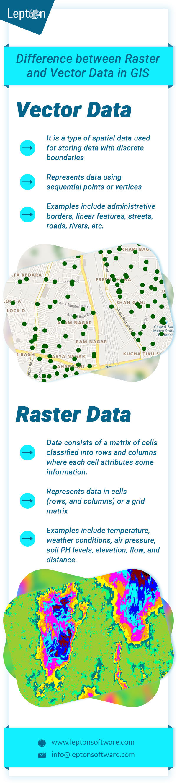
Raster vs Vector Data in GIS
Difference between Vector Data and Raster Data in GIS. Click to know more about best Desktop GIS Mapping Software.
0 notes
Text
Global Mapper GIS Software For PC
Global Mapper GIS Software For PC
Global Mapper is a powerful GIS software for PC that will enable users to handle multiple specific formats, perform complex analysis processes, create map layouts, or even deal with LiDAR data.
Now in its third decade of development, Global Mapper continues to cause a stir in the worldwide geospatial community. From its humble beginnings as a simple data viewing utility, it has evolved into a maj…
View On WordPress
#geographic data#Geographical Data#GIS Data#Global Mapper#Global Mapper For PC#Global Mapper For Windows#Lidar Cloud#raster calculator
0 notes
Text
Doubling the Tiger Numbers to Meet Tx2 Goal by Year 2022 : GIS Based Delineation to Explore the Fundamental Fallacies
Doubling the Tiger Numbers to Meet Tx2 Goal by Year 2022 : GIS Based Delineation to Explore the Fundamental Fallacies
Doubling the Tiger Numbers to Meet Tx2 Goal by Year 2022 : GIS Based Delineation to Explore the Fundamental Fallacies
Mohammed Ashraf
Wild tiger marking its home range
Wild tigers (Panthera tigris) are charismatic mega-carnivore in felid guild that serve as flagship keystone species in tropical and semi tropical ecosystems across South and South East Asia. Historically tiger populations range…
View On WordPress
#Bengal Tiger#Carnivore Ecology#Cougar#GIS Data#GIS Map#Global Tiger Recovery Proggram#GTRP#Habitat Fragmentation#Indo Malayan Ecosystems#IUCN#Jaguar#Mark Elbroch#Mountain Lion#Obligate Carnivores#Panthera#Puma#TX2#World Wildlife Fund
0 notes
Link
Data is an essential part of Geographic Information Systems. With accurate and updated GIS data, you can develop strategies, automate workflow, target customers, and optimize processes. It is often used in link-node topology and polygon topology.
0 notes
Text
Mobile Web Application Developer, Chapel Hill, NC, USA
Mobile Web Application Developer, Chapel Hill, NC, USA
Mobile Web Application Developer
Chapel Hill, NC (Non-Local, OK)
6 months
Phone and Skype
This calls for a 6 month consultant to develop a web-based mobile friendly interface to an already built data acquisition system built on ELK Stack. The foundation for this data acquisition system has already been built; meaning the architecture has been built, they are running back-end code but the UI piece…
View On WordPress
#django#docker#elastic search#elk stack#GIS data#grafana#katfa#kubana#logstash#mobile web developer#python#UI
0 notes