#GeoAI
Explore tagged Tumblr posts
Visit Tumblr Blog
Explore Tumblr blogs with no restrictions, modern design and the best experience.
Last Seen Tumblr Blogs


Fun Fact
The total number of visits Tumblr.com received during January 2021 is 327 million.
Text
rande successo per la Conferenza Esri Italia 2025: due giornate tra intelligenza artificiale, digital twin e la presentazione del libro sui viaggi di Papa Francesco. Scopri di più su Alessandria today.
#Alessandria today#Ama#Andrea Benedetti#Annalisa Barla#ArcGIS#AUBAC#città intelligenti#conferenza Roma#data science#dati territoriali#Digital Twin#Esri Conference 2025#Esri Italia#Esri Professional Summit#Esri Stories#geoAI#geointelligenza#geolocalizzazione#Geosmartcampus#GIS#Google News#greenaccord#Innovazione digitale#Intelligenza artificiale#Istituto Idrografico Marina#italianewsmedia.com#Lava#libro interattivo#Microsoft#Papa Bergoglio
0 notes
Text
This in-depth exploration of Geographic Information Systems with Artificial Intelligence (GeoAI) shows how this revolutionary technology is transforming spatial analysis across industries. From urban planning and disaster management to precision agriculture and retail intelligence, GeoAI combines machine learning, deep learning, computer vision, and spatial data to solve complex geographic problems with unprecedented accuracy and efficiency. This post covers the three core pillars of GeoAI: spatial data infrastructure, AI algorithms, and computational resources, while tracing its evolution from manual mapping to today's autonomous systems. Readers will discover key technologies driving innovation, including computer vision for earth observation, NLP for geographic information retrieval, and reinforcement learning for routing optimization. I request you to have a read and engage with the post, mentioning what do you think where will the Geospatial Industry be in the upcoming years until 2030. Do share it within your professional networks and spread the word of GeoAI and how it is transforming the Geospatial industry.
#ai#ArtificialIntelligence#DeepLearning#DigitalTransformation#FutureofTechnology#GeoAI#geographicinformationsystems#Geospatial#gis#Innovation#locationintelligence#MachineLearning#RemoteSensing#SpatialData#technology
0 notes
Text
Esri User Conference 2024: The world’s largest GIS conference (July 15–19, 2024 | San Diego, California).
iSpatial Techno Solutions (IST) will be exhibiting at the Esri User Conference 2024 in San Diego, CA. This event gives an opportunity for IST as we showcase our cutting-edge GIS and AI solutions that are shaping the future of sustainability and energy.

Sustainable Innovation

At IST, our commitment to sustainability drives our innovation. We are leveraging Esri's powerful GIS technology to develop solutions that help communities and organizations achieve their sustainability goals. Our advanced tools enable precise environmental monitoring, helping local and city governments to make informed decisions that promote ecological balance and resource conservation.
Leading Grid Modernization

The utility and energy sectors are evolving, and IST is at the forefront with Esri's Utility Network solution. Our expertise enhances operational efficiency, service reliability, and infrastructure management. We help utility providers optimize networks, reduce outages, and meet the demand for clean energy.
Advancing with Geo AI and Generative AI

They have a pioneering approach integrates Geo AI and Generative AI to convert data into actionable intelligence. These technologies offer local and city governments unparalleled insights, enabling them to tackle complex urban challenges effectively. From predictive analytics to real-time data visualization, our AI-driven solutions provide the essential tools for proactive decision-making and strategic planning.
Visit IST at Esri UC 2024
Join IST at Booth 1113 at Esri UC 2024 to discover how IST's solutions are making an impact. Engage with our experts to learn about our projects, experience live demonstrations of our technologies, and explore collaboration opportunities to drive sustainability and innovation in your organization.
Stay connected with IST on social media live updates, exclusive content, and behind-the-scenes insights from the conference.
If you want to work together to shape a sustainable and intelligent future. For more information, visit our website or contact us directly at [email protected].
We look forward to meeting you at Esri UC 2024!
#esri uc 2024#Esri user conference#Esri user conference 2024#esri uc#ArcGIS Utility Network#GIS#GEOAI#Geo analytics#Location Intelligence#ArcGIS enterprise#Esri#Geospatial#ArcFM#Asset Management#Geodatabase#ArcMap#Geometric#ArcGIS Pro#Web App Builder
1 note
·
View note
Text
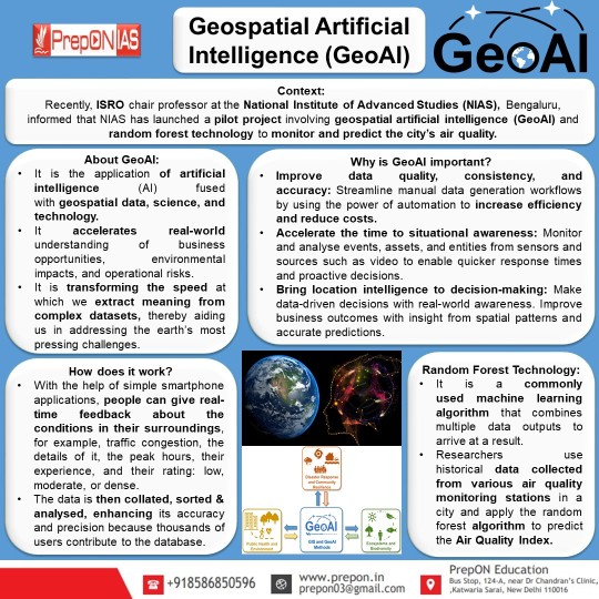
Geospatial Artificial Intelligence (GeoAI)
#geospatialartificialintelligence#geoai#artificialintelligence#nias#nationalinstituteofadvancestudies#foresttechnology#airquality#scienceandtechnology#AirQualityIndex#dailycurrentaffairs#currentaffairs#GeneralKnowledge#upsc#upscprelims2024#upscprelims#upsc2023#infographic
1 note
·
View note
Text
This was a labour of love. I saw that there were so many different Black LGBT labels, that I figured it'd be good to consolidate everything into one easy to find Carrd! Please reblog so the word gets out. I want Black individuals to feel pride in their queer identities!
218 notes
·
View notes
Text
For those of you who lack reading comprehension skills, this poll is meant for BLACK... I'll say it again, BLACK. Diasporic. Queer people. If that's not you, just keep scrolling.
If you're looking for examples of what I'm talking about, you can check out this carrd, or even browse around this blog. There's no right answer, I'd just like to see where the community is at.
#blood 𓂅 ✦﹕talking#i'm sorry for saying children of the diaspora i couldn't think of a better way to put it#i swear i'm not a hotep#black exclusive#black queerness#black lgbt#geoay
3 notes
·
View notes
Text
Invited Guest Speaker at the Taylor Geospatial Institutes GEOAI Gathering
Manil Maskey (ST11/IMPACT) was an invited guest at the Taylor Geospatial Institute (TGI) GeoAI gathering. He presented on the Harmonized Landsat Sentinel-2 (HLS) based geospatial foundation model and the recent developments in weather and climate foundation model. Following the presentation, Maskey engaged in discussions that led to several agencies expressing interest in collaborating with IMPACT […] from NASA https://ift.tt/BrJ2w8o
#NASA#space#Invited Guest Speaker at the Taylor Geospatial Institutes GEOAI Gathering#Michael Gabrill
0 notes
Text
Use remote sensing foundation models with #ArcGIS
https://www.esri.com/arcgis-blog/products/arcgis-pro/geoai/use-remote-sensing-foundation-models-with-arcgis
0 notes
Text
The Rise of Intelligent Maps: GIS AI Services in Malaysia
The Rise of Intelligent Maps: GIS AI Services in Malaysia
Geographic Information Systems (GIS) have long been indispensable tools for mapping, analysis, and decision-making across various sectors in Malaysia. From urban planning in bustling Kuala Lumpur to managing the rich biodiversity of Borneo, GIS provides critical spatial insights. However, a new era is dawning, one where the power of Artificial Intelligence (AI) is being seamlessly integrated with GIS, promising to unlock unprecedented levels of efficiency, accuracy, and predictive capabilities. This fusion is giving rise to a dynamic landscape of GIS AI services in Malaysia, poised to revolutionize how we understand and interact with our world.
What is GIS AI?
At its core, GIS AI involves leveraging AI algorithms and techniques within a GIS framework. This integration goes beyond simply visualizing spatial data; it enables systems to learn from patterns, automate complex analyses, and even predict future spatial events. Think of it as adding a layer of intelligent interpretation and automation to the already powerful capabilities of GIS.
Several key AI technologies are driving this evolution in Malaysia:
Machine Learning (ML): Algorithms that allow GIS to learn from data without explicit programming. This includes techniques like classification, clustering, and regression, enabling tasks such as land use classification from satellite imagery or predicting areas prone to landslides.
Deep Learning: A subset of ML that utilizes artificial neural networks with multiple layers to analyze complex data like high-resolution imagery and LiDAR data, facilitating tasks like object detection (e.g., identifying buildings or vehicles) and semantic segmentation (e.g., delineating different types of vegetation).
Computer Vision: Enables GIS to "see" and interpret visual information from images and videos, crucial for applications like automated feature extraction and change detection.
Natural Language Processing (NLP): Allows users to interact with GIS using natural language queries, making spatial analysis more accessible to non-experts.
The Malaysian Landscape: Early Adoption and Potential
While still in its nascent stages, the adoption of GIS AI services in Malaysia is gaining momentum. Several local players and international companies operating in the region are beginning to offer or explore AI-enhanced GIS solutions.
Companies like IDERIA Sdn Bhd are actively promoting their "AI-GIS" software, emphasizing its capabilities in automating editing, analysis, and cartography. They also highlight its scalability and web-enabled features, making geospatial content accessible across organizations.
GIS Innovation Sdn Bhd, a Malaysian-based company with extensive experience in GIS solutions, partners with Safe Software's FME, a no-code platform for integrating and transforming spatial data, which can be a crucial step in preparing data for AI analysis.
Furthermore, established GIS technology providers like Esri Malaysia and RedPlanet Grp (partnering with SuperMap) are highlighting the integration of AI into their platforms. SuperMap, for instance, emphasizes "AI GIS" as one of its core technology systems, focusing on GeoAI (spatial analysis algorithms integrated with AI) and AI for GIS (enhancing GIS software functionality with AI).
Benefits of GIS AI: A Game Changer for Malaysia
The integration of AI into GIS offers a multitude of benefits for various sectors in Malaysia:
Enhanced Decision-Making: AI can extract more profound insights from complex spatial datasets, providing actionable intelligence for data-driven decisions in areas like urban planning, resource management, and disaster response.
Increased Efficiency and Automation: Repetitive and time-consuming GIS tasks, such as data cleaning, feature extraction, and change detection, can be automated using AI, freeing up human analysts for more strategic work.
Improved Accuracy and Precision: AI algorithms can analyze vast amounts of geospatial data with greater accuracy and precision than traditional manual methods, leading to more reliable results.
Predictive Analytics: GIS AI can identify patterns and trends in spatial-temporal data to forecast future events, such as traffic congestion, disease outbreaks, or environmental changes, allowing for proactive planning and mitigation.
Real-Time Insights: By processing real-time data streams from sensors, IoT devices, and other sources, GIS AI can provide up-to-the-minute spatial intelligence for applications like smart city management and emergency response.
Optimized Resource Allocation: AI-powered GIS can analyze spatial demand and distribution to optimize the allocation of resources, whether it's for logistics, public services, or environmental conservation efforts.
Applications Across Malaysian Industries
The potential applications of GIS AI services in Malaysia are vast and span across numerous industries:
Urban Planning and Smart Cities: AI can analyze urban sprawl, traffic patterns, and population density to optimize city planning, improve infrastructure development, and enhance the efficiency of public services. Imagine AI predicting traffic bottlenecks in Kuala Lumpur and suggesting dynamic traffic light adjustments.
Agriculture and Natural Resource Management: AI can analyze satellite imagery to monitor crop health, predict yields, detect deforestation, and manage wildlife habitats more effectively, contributing to sustainable agriculture and environmental conservation in Malaysia's diverse ecosystems.
Disaster Management: GIS AI can be crucial in predicting and responding to natural disasters like floods and landslides, which are significant concerns in Malaysia. AI can analyze historical data, weather patterns, and terrain information to identify high-risk areas and optimize evacuation plans.
Telecommunications: AI-powered GIS can assist in network planning and optimization for telecommunication companies, ensuring efficient coverage and identifying areas for infrastructure upgrades, particularly important for expanding 5G connectivity across Malaysia.
Logistics and Transportation: AI can optimize delivery routes, manage logistics networks, and improve transportation efficiency, reducing costs and travel times for businesses operating throughout Malaysia.
Environmental Monitoring: AI can analyze remote sensing data to monitor air and water quality, track pollution sources, and assess the impact of climate change on Malaysia's environment.
Land Management: Integrating AI and GIS can improve the efficiency and precision of land allocation systems, aiding in decision-making and promoting sustainable land use practices.
Challenges and the Path Forward
Despite the immense potential, the widespread adoption of GIS AI services in Malaysia faces certain challenges:
Data Availability and Quality: Training effective AI models requires large volumes of high-quality, spatially referenced data, which may not always be readily available or standardized across different regions and sectors in Malaysia.
Technical Expertise: Implementing and utilizing GIS AI solutions requires skilled professionals with expertise in both GIS and AI, and there might be a shortage of such talent in the Malaysian market.
Computational Resources: Processing large geospatial datasets and training complex AI models can be computationally intensive, requiring access to robust infrastructure.
Integration with Existing Systems: Integrating new GIS AI solutions with existing legacy GIS systems and other enterprise IT infrastructure can be complex and costly.
Privacy and Ethical Considerations: Handling location data raises significant privacy concerns that need to be addressed through appropriate regulations and ethical guidelines.
To overcome these challenges and fully leverage the power of GIS AI in Malaysia, several steps are crucial:
Investing in Data Infrastructure: Efforts to improve the collection, standardization, and accessibility of high-quality geospatial data are essential.
Developing Local Talent: Educational institutions and industry training programs should focus on building expertise in both GIS and AI.
Promoting Collaboration: Collaboration between government agencies, research institutions, and the private sector can foster innovation and knowledge sharing in the field of GIS AI.
Establishing Clear Guidelines: Developing clear policies and ethical frameworks for the collection, use, and sharing of geospatial data is crucial to address privacy concerns.
The Future is Intelligent: GIS AI in Malaysia
The integration of AI into GIS represents a significant leap forward in our ability to understand and interact with the spatial world in Malaysia. As AI technologies continue to advance and become more accessible, we can expect to see a proliferation of innovative GIS AI services that address a wide range of challenges and opportunities across the nation. From smarter cities and sustainable resource management to more effective disaster response and optimized business operations, the future of GIS in Malaysia is undoubtedly intelligent, promising a more informed, efficient, and resilient nation. The journey has just begun, and the potential is truly limitless.
0 notes
Text
Why GeoWGS84 Leads the Way in GeoAI Innovation
In the ever-evolving landscape of geospatial technology and artificial intelligence, GeoWGS84 has emerged as a trailblazer. By seamlessly integrating geospatial data with AI-driven insights, GeoWGS84 is redefining how industries analyse, visualize, and act on location-based data. But what makes GeoWGS84 stand out in the crowded world of GeoAI?

https://www.geowgs84.com/post/why-geowgs84-leads-the-way-in-geoai-innovation
0 notes
Text
Geo Week 2025 in Denver, CO – A Who’s Who Event in The World of GIS Technology

An accomplished senior executive with extensive experience in the Esri GIS Consulting industry, Jerry Corr has served as the CEO of Ocean Sky Consulting Inc. for more than 21 years. In this role, he leads a team of contract staff, delivering solutions to Esri utility and AEC clients. Jerry Corr recently attended of the 2025 GEO Week event in the Denver Convention Center in Colorado. GeoWeek was held in the Denver Convention Center from February 10-12, 2025. Geo Week is the premier event for increased integration between the built environment, advanced airborne/terrestrial technologies, and commercial 3D technologies.
Geo Week was created as a response to the changing needs of built world and geospatial professionals, and to acknowledge the convergence of technology taking place currently. New technological innovations, the need for remote workflows, and hardware breakthroughs are redefining expectations across teams, organizations, and entire industries.
The DFW Airport was one of the keynotes at GEO Week this year, DFW Airport’s Digital Evolution: 3D, AI/ML, and Event-Driven Architecture in Action. It was presented on Monday, February 10, 2025 from 12:00 PM to 1:00 PM. The DFW Airport is a fast-paced, complex environment that requires informed decision-making. The Airport is the third 3rd largest airport globally, with two major terminal construction projects, a new electric plant project, and aging utility improvement projects.
DFW is also experiencing massive growth in passenger volumes, which requires operational improvements and increased efficiencies. The airport also deals with ongoing threats that require real-time information flow for decision process and collaboration. These challenges present excellent opportunities to leverage 3D visualization, AI/ML, and event-driven architecture to solve critical use cases supporting Utility Management, Terminal Operations, and Emergency Management.
Their keynote touched on key areas of the project:
Utility Management: Exploring how DFW Airport enhances utility management by combining GIS mapping with digital twin and predictive insights.
Terminal Operations: Showcasing how DFW Airport is using customized geospatial solutions and digital twins to improve emergency management.
Customized Airport Solutions: Demonstrating how DFW Airport integrates pre-incident planning maps with reality capture and dispatch systems, enhancing response readiness.
This high-level keynote included a discussion of GIS, digital twins, real-time event monitoring, vehicle sensors, GeoAI, deep learning models, 3D mapping, and meshing imagery. It was paired with a “deep dive” session in the Geo Week conference program.
0 notes
Text
How AI Technology is Transforming Agriculture to Combat Hunger

In the face of escalating global food scarcity, leveraging advanced technologies has become crucial for enhancing agricultural efficiency and securing food supplies. Artificial Intelligence (AI) is at the forefront of this technological revolution, offering innovative solutions across various facets of farming.
From remote crop monitoring to precision irrigation, AI-driven advancements are transforming traditional agricultural practices and addressing some of the most pressing challenges in food production.
Remote crop monitoring, combined with 5G technology, enables farmers to oversee and manage their crops with unprecedented accuracy from a distance. This approach offers critical insights into crop health and resource usage, optimizing yield and reducing waste.
Similarly, AI's role in seed genetics and precision fertilizers is pivotal in developing resilient crop varieties and optimizing nutrient delivery, which is essential for enhancing productivity and sustainability.
In addition to these advancements, AI-powered mobile apps and intelligent food transit systems are revolutionizing how farmers receive real-time guidance and manage food distribution.
These technologies help in optimizing resource use, reducing food waste, and improving food security globally. AI-driven vertical farming and GeoAI further contribute by improving resource efficiency and monitoring crop conditions through advanced imaging techniques.
Livestock monitoring through smart sensors is another groundbreaking application, offering real-time health data and early disease detection, thus enhancing herd management and productivity.
Together, these AI innovations present a comprehensive approach to tackling global food scarcity and fostering a more sustainable agricultural future.
Using AI to Improve Agricultural Efficiency and Alleviate Hunger
1. Remote Crop Monitoring
Remote crop monitoring is emerging as a groundbreaking application of artificial intelligence (AI) in agriculture. This technology, particularly when combined with 5G, offers significant potential for addressing global food scarcity issues. AI-driven remote crop monitoring involves using advanced technologies to oversee and manage crops from a distance, providing valuable insights into crop health, growth, and resource usage.
Impact of 5G Technology in Agriculture
The integration of 5G technology with AI in agriculture is particularly transformative. In countries like Japan, where an aging population and a declining workforce pose substantial challenges to the agricultural sector, 5G-powered AI solutions are proving to be highly beneficial. The high-speed and low-latency capabilities of 5G networks enable real-time data collection and transmission, which is crucial for effective crop monitoring.
Read More
0 notes
Text
Transform Utility Management with GIS & GeoAI | iSpatial Techno Solutions
Transform utilities & asset management with iSpatial Techno Solutions. Advanced GIS & GeoAI drive smart, efficient, and data-driven decisions.
#GIS Solutions#Utility Management#GeoAI Technology#Asset Management#Smart Utilities#GIS for Utilities
0 notes
Text


Mwarian!
A term coined for Black Diamoric Individuals!
I decided to make Mwarian after being inspired by Erosian and Oshian (Black Sapphic Love and Black Turian Love respectively). There wasn't a term that I could find that represented Black Diamoric Love, so this is where Mwarian comes in!
The flag itself has 7 stripes each with individual meanings:
-Black: Representing Multigendered and Nonbinary Individuals -Dark Brown: Representing Black Pride -Medium Brown: Representing Black Culture -Light Brown: Representing Black Love -White: Representing a Lack of Gender -Light Green: Representing Enbian/ NBLNB love -Dark Green: Representing NBLW and NBLM Love
Like it? Love it? Hate it? Let me know! My inbox is open c:
Would really appreciate any and all reblogs to help get the word out!
91 notes
·
View notes
Text
good morning everyone!
i just wanted to give a warning that i have a bunch of wonderful flags made by our black peers queued to reblog, while i work on some more flags of my own. so, if you’ve come here for the “archival” aspect of this blog, your prayers will soon be answered! they should be coming out about three times a day, for the next few days.
( i’ve genuinely scoured all of tumblr, and i don’t think it comes as a shock that there wasn’t much to see. most of the stuff you can find here comes from twitter, or can be found here on the geoay carrd. most everything else comes from my friends @/vampitsm and @/gender-goth, holding down the black mogai fort. )
if you’re here to see what i have to offer in terms of flags, i promise you won’t have to wait much longer. and this is a friendly reminder that i do take requests, and anything you all requested would take precedence over anything i’m planning to do.
lastly, to all my new followers, welcome to blkmogai and thank you for joining us! and to my day one’s ( @/abandondedknowledge aka gender-goth and @/sweetdataboy ) thank you so much for supporting me through this journey. that’s all from me, folks. have a lovely saturday!

4 notes
·
View notes
Text
Apply now: https://canadianjobbank.org/developer-software-9/
0 notes