#Geography Notes
Explore tagged Tumblr posts
Visit Tumblr Blog
Explore Tumblr blogs with no restrictions, modern design and the best experience.
Last Seen Tumblr Blogs


Fun Fact
Tumblr was acquired by Yahoo for $1.1B in 2013.
Text
Chapter wise Topic wise Notes

Download free Chapter Wise Topic Wise Notes for Class 9 to 12
Chapter Wise Topic Wise Notes for Classes 9 to 12 are carefully structured study materials that cover each chapter and topic in the syllabus, designed to help students grasp concepts easily and thoroughly. These notes break down each chapter into key topics, summarizing important theories, formulas, definitions, and explanations in a concise and easy-to-understand format. By organizing the material chapter-by-chapter, students can quickly locate and review specific areas, making it easier to focus on weak areas and retain information.
#Chapter-Wise Notes#Topic-Wise Notes#Exam Preparation Notes#Important Concepts#Class 11 Notes#Class 12 Notes#Chemistry Notes#Biology Notes#Geography Notes#Business Studies Notes
0 notes
Text
This is a very long post. If you do not have the time, then please at least do the quick activity up top. The lesson plan that took me 4 days to write will follow the ⁜ symbol.
HW Due Mon:
Open https://mysolartime.com/ in a new tab and allow the website to track your location.
Open https://www.utctime.net/ in a new tab.
Reblog this post the current UTC time and your local time, using the following format:
21:00 UTC, 4:00 local
4. Vote in the following poll.
⁜
Social Studies, Grade 5, Geography 6.1.5.GeoSV.3: Demonstrate how to use digital geographic tools, maps and globes to measure distances and determine time zones, and locations using latitude and longitude.
Do Now:
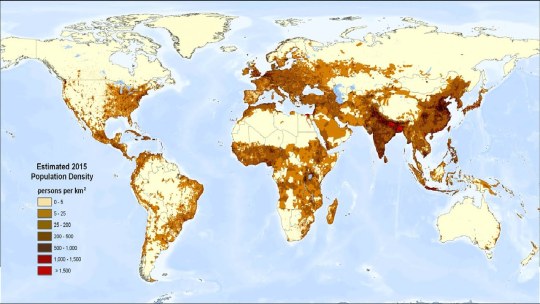
Provide students with a paper copy of a population density world map and 2 minutes to fulfill the following instruction:
Draw lines on the map in order to separate the world into 24 time zones. Try not to separate dense population centers into different time zones.
⁎
Class Discussion:
Use the projector to share and discuss the maps of any students who are willing to share. Have fun with this, there are bound to be some good ideas and bad ideas because 5th grade is like that.
Then, project the official world time zone map, and discuss the good ideas and bad ideas present here.


Exemplary discussion points:
The 0-point of the timezone map is the Prime Meridian, which cuts right through England. Why do you think it's in England?
How come some countries like the US and Brazil are cut into multiple time zones, but China isn't?
Why do you think the lines are pretty straight in Europe, Africa, and North and South America, but so confused in Asia and the Atlantic and Pacific Oceans?
⁑
Direct Instruction:
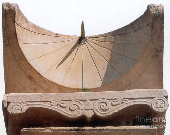
Long ago, nobody really cared about the exact time. All you really needed was sunrise, sunset, and noon, and you could figure those out with your eyes. If you wanted to be fancy, you could put a stick in the ground and trace its shadow over the course of the day to measure out hours.
Perhaps the first recorded complaint of time-keeping technology comes from Rome in 250BCE.
The gods confound the man who first found out how to distinguish hours! Confound him too Who in this place set up a sundial To cut and hack my days so wretchedly Into small portions! When I was a boy, My belly was my sundial: one more sure, Truer, and more exact than any of them. This dial told me when it was time To go to dinner, when I had anything to eat; But nowadays, why even when I have, I can't fall-to unless the sun gives leave. The town's so full of these confounded dials, The greatest part of its inhabitants, Shrunk up with hunger, creep along the streets. [x]
In other words, "Kids these days are always looking at their sundials. Back in my day, there were only three times, Breakfast, Lunch, and Dinner. All we needed to tell the time was our stomach!"
Please note this was a satire, so if it sounds funny, you are correct.
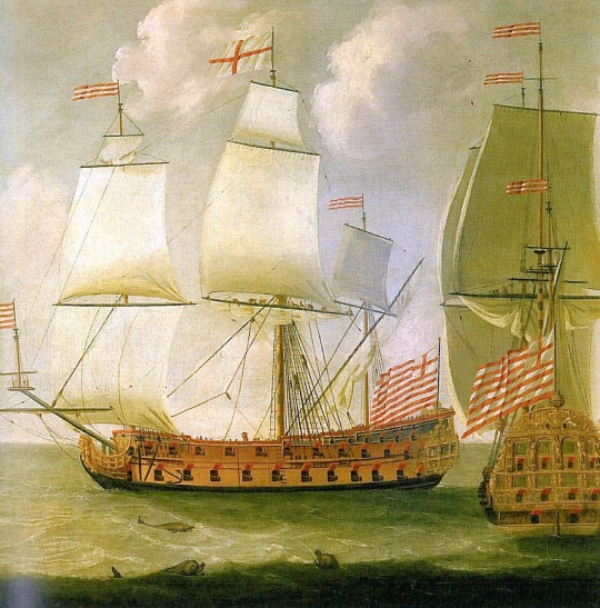
But for 18th century British sailors, accurate timekeeping was no laughing matter. These sailors used fancy math (called trigonometry) to calculate their latitude. So long as they knew the angle between the sun and the horizon, and the time when that angle was measured.
Ship's captains would keep logbooks of these measurements. That way, another ship's captain would be able to reference the logbook in order to replicate the journey, much like replicating a science experiment.
Now... think about this... how can you do that unless the next captain is using the same time as you. We take this for granted today, but how can you be sure that two clocks are synchronized?
Scientists in the town of Greenwich, England (pronounced gren`-ich) recorded the solar noon every day of the year and calculated the Greenwich Mean Time. By keeping an accurate and exact time in one exact place, GMT eventually the Coordinated Universal Time (UTC) for everyone in the world. That's why in the time zone map, the 0 runs through one specific part of England.

This is important. For the first time in human history, the clocks in different places were synchronized. Solar noon happens at a different time in London than it does in Greenwich, but if they both use GMT (otherwise known as UTC), then they can coordinate their schedules. This was very important for railroads, where exact, coordinated schedules are very important.
Soon, the entire country of England existed within a single time zone.
When the United States built railroads that spanned vast lateral (East-West) distances, they needed to create different time zones for cities that were far apart from each other, such as New York and Chicago. Thus, the US became the first country with multiple time zones.
As the rest of the world industrialized, they needed to pick their time zones. You can see this on the map. Each time zone is, at least in theory, as wide as 1/24 the circumference of the Earth. It's like the space between the numbers on a clock! Most countries are smaller than this, so they can comfortably fit within a single timezone. Others, like Brazil and Australia, divided their landmasses into two or three time zones.
China did not have widespread industrialization until post-WWII dictatorial communist rule. This was a very uncaring and inconsiderate government, to put it mildly. Suffice it to say that for Chinese farmers in the far west, having to get up 2-3 hours earlier every day would have been the least of their worries.
⁂
Modeled Activity:
Show students how to use this Day and Night world map as a way to visualize the day and night cycle across the world.
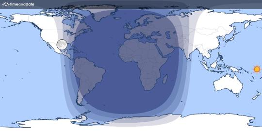
Additionally, show them how to use https://mysolartime.com/ to find their current time where they live.

Give students a moment to calculate the difference between their Local Time and the official time in their time zone, and what that means.
(I am currently in Philadelphia, which is 11 minutes East of New York City)
Finally, show students how to use https://www.utctime.net/ to find their exact, current UTC.

Have students calculate the difference in minutes and hours between Local Time and Official Time.
00:41 - 19:30 = -5:11 (Philadelphia is 5 hours and 11 minutes East of Greenwich, England)
Explain that every internet connected device in the world uses a service like this one, then adds or subtracts hours to fit the time zone of your current location.
Higher Order Learning:
Students work in small groups to look up the local time in different major cities around the world, recording their data on a worksheet. As they do, they should discuss the following questions:
Are time zones still relevant in our always-online society?
If you can know your Local Time and the UTC any time you look at your phone, then what purpose do time zones still serve?
How would it feel for schools and businesses to use UTC instead?
How would you feel if your school day went from 4:20-10:50 UTC?
Finally, each student must individually write at least 3 sentences responding to the following question:
Would you advocate for or against your school district dropping references to the time in your time zone and instead referring to UTC and Local Time? Why or why not?
#lesson plan#social studies#grade 5#geography#poll#polls of tumblr#tumblr poll#teachblr#I JUST WANTED TO ASK A QUESTION BUT I KEPT ON RAMBLING IN THE NOTES AND THEN I WAS LIKE “THIS IS A LESSON ISN'T IT”#AND THEN I SPENT THE NEXT 3 DAYS DOING BASICALLY NOTHING WITH MY FREE TIME EXCEPT RESEARCHING AND WRITING THIS LESSON#I HOPE YOU ALL LEARN SOMETHING BECAUSE I DID
120 notes
·
View notes
Text


29|05|2025
first day of actually attempting to lock in! i still haven’t done any english even though that’s my first exam but im hoping i can cover it on the day beforehand because im normally quite good at english. i should also be covering more maths as thats a subject ive been failing for a while now, but here’s what ive done today -
📚i started with 1 hour and 10 minutes of home economics where i covered milk, fish and protein alternatives but i didn’t finish it fully.
📚soon after i spent only 30 minutes drawing out river diagrams for geography but i still need to look over them again because i don’t remember it all.
📚then in the afternoon i did a full hour of irish and wrote out flash cards for ghleann álainn. (i pray this doesn’t come up in the exam.)
📚to finish off the evening i did another full hour of history and i wrote out notes for early christian ireland but again i didn’t fully complete the chapter so hopefully ill finish it tomorrow.
#study motivation#study notes#study inspiration#study blog#study aesthetic#school work#study#exam season#exampreparation#education#junior cert#leaving cert#homework#revision#ireland#home economics#geography#irish#history
101 notes
·
View notes
Text
USA PATCH NOTES
-made Wisconsin significantly larger by absorbing several other states into it, as well as giving it most of Michigan
-minnesota is now an independent country
-made missouri much smaller (much of what used to be missouri now belongs to wisconsin)
-resolved v-fighting between utah and wyoming
-split the rest of Michigan between ohio and indiana
-the entire delmarva peninsula is now part of Washington, D.C.
-gave georgia's coastline to south carolina
-further divided the dakotas
-southern montana is now part of southwest dakota
-the alaskan panhandle is now canadian
-3 of the hawaiian islands are now part of mexico
-merged arizona, nevada, and southern california into a single state
-alabama and mississippi's coastlines are now floridian
-oklahoma is now very very long
-eastern texas is now in louisiana
-arkansas is slightly larger
-western texas is part of new mexico
-merged northern california, western oregon, and the entirety of washington into a new state
-eastern oregan is part of idaho
-the idaho panhandle is now a separate state
-rotated the border between virginia and north carolina by 90° (virginia in the east, NC in the west)
-merged kentucky, east tennessee, and the maryland panhandle into west virginia
-merged the rest of maryland as well as most of western new york into Pennsylvania
-merged eastern Massachusetts and all of new hampshire into maine
-merged western massachusetts, new york city, long island, and all of new jersey into vermont
-renamed colorado to squareland
-rhode island is entirely unchanged

#america#patch notes#geography#if someone wants to redo this with cleaner lines then by all means go for it
120 notes
·
View notes
Text
⚓World Overview
I finally got around to Compiling the world Document into something nice for you all! Don't worry, there will be art soon!
⚓Directory


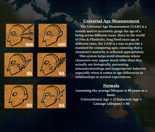


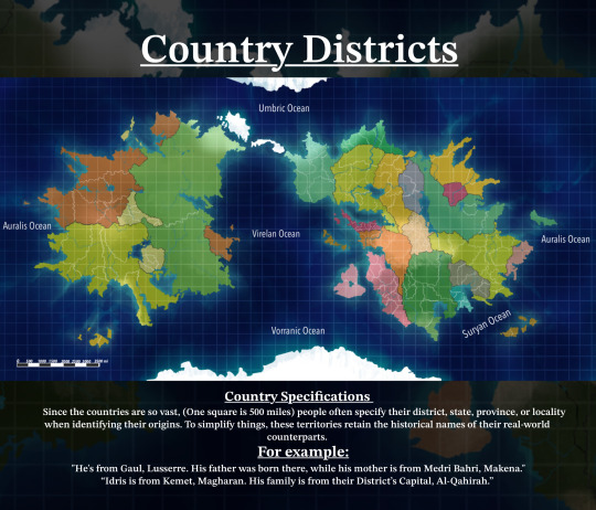
#world notes#lore#geography#filo#fins & flintlocks#original character#web series#art#webcomic#worldbuilding#artwork#fins and flintlocks
48 notes
·
View notes
Text

that’s just rome i think (met 4 trans. mccarter)
#mcamorphoses#mccarter’s notes say this draws on aeneid 6 and. yeah. where the underworld is ALSO the geography of augustan rome#my two fave of all time variants on ‘there seems to be elected government and criminal courts in the underworld’ are of course#‘the ghosts of dead populares are doing agrarian reform and redistributing the elysian fields’ in lucan#and a ghost politician called ‘cranion son of skeletion from the deme necysia’ in lucian’s dialogues of the dead#i.e. skull son of skeleton from the corpse deme#really really good#metamorphoses#beeps
37 notes
·
View notes
Text
LoZ: Ternary Ages △ World of Hyrule
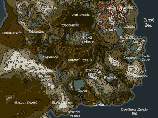

⚔ Hyrule Overworld
Hyrule is broken into 9 major regions: Central Hyrule, Faron, Necluda, Lanayru, Eldin, Woodlands, Hebra, Tabantha, and Gerudo. Smaller regions such as Lost Woods, Akalla, Lurelin, Ridgelands, and the Barren Basins fill the gaps.
The colored map highlights the territories of the existing nations. The Sheikah of Necluda and Hylians os Faron/Lurelin are considered in Hyrule proper but are still unique nations.
The Rito have not unified and the Kokiri do not consider themselves a 'nation.'
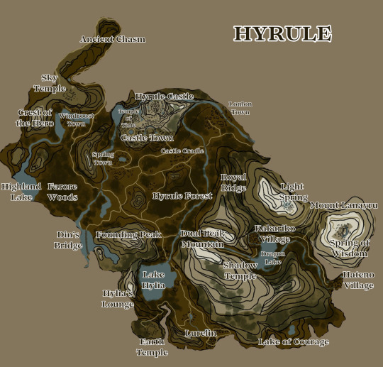
❇ Central Hyrule
Leader: Hylian Royal Family (King Rhoam, Queen Zirda, Princess/Queen Zelda)
Allies: Zora, Goron, Kokiri, Sheikah, Lurelins
Adversaries: Gerudo, Hebra Rito
Neutral: Tabantha Rito
Sage of Light - Zirda | Triforce of Wisdom - Zelda
Central Hyrule is the land of Hylia, filled with sloping plains, green grass, gentle winds, and elegant mountains reaching for the heavens. The land is rich with grains, fruit, lumber, cattle, and fresh water bodies. Dotting the plains, hills, and forests are small towns, surviving on cattle and the land, harvesting and trading to stay afloat in their prosperity. On an inselberg, north of the nation, sits Hyrule Castle and its town. Bustling with trade, music, and wealth, the town and castle are architectural beauties, densely populated and only silent at night. Cathedral structures, cool cobalt stone, and glorious red banners lined with golden embroidery loudly announce abundance. Nothing beats the Temple of Time, a huge ancient structure said to protect the gate to the Sacred Realm, where Hylia rests. Gardens with archways, marble altars, and murals are scattered throughout. Castle Town is known for its grand festivals and parties, adoring their king, queen, and princess and praying for the Hero. It' people worship the primordial goddess Hylia and the Three Golden Goddesses: Farore, Din, and Nayru. Their sovereign leader is the reigning royal family, a monarchy known for their generosity to their people, divine powers, and a desire to unify the land at large.
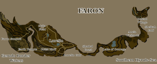
𑁍 Lurelin/Faron
Leader: N/A
Vassal nation to Hyrule
Hero of Courage/Triforce of Courage - Link
South of Central Hyrule, Faron is a wet and coastal region, littered with some dense woodlands abundant with rain. Its people are all former pirates and seafarers, having settled in this coastal region after the Great Sea pulled away, revealing its lush, fertile soils. Trades of fishing, butchery, woven mercantile, glorious fabrics and tapestries, and ivory/shell material have earned the area a name for itself. The region is a vassal to Hyrule, serving its royal family and has no internal governmental structure. While they worship Hylia, the land is said to be Farore's birthplace so her divinity is highly respected here, thus, so is the Hero. The Hero is worshipped and all children are prayed to be the Hero. The Earth Temple is here.
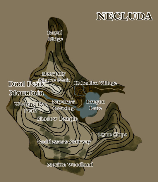
𓁿 Necluda
Leader: Sheikah Elder, Diya
Vassal state to Hyrule.
Sage of Shadow - Parrane
Necluda is the mountainous valley home to the Sheikah tribe, a collection of white-haired people who have long served the Hylian royal family and institution. Often called the 'Shadow People,' the Sheikah are very secretive in their valley, keeping close, barred watch on its eastern border with Lurelin. Kakariko Village, if reached, is friendly and sacred. Legend says that dragons are born from their neighboring lake, swirling into the sky and cutting through the famous, notably Dual Peaks. The Sheikah are masters in stealth, potions and oils, balms, chicken byproducts, and metallurgy. The people are led by the Sheikah Elder, Diya. Her niece, Impa, serves as Hyrule's princess' guard. The Sheikah nobody Parrane would eventually awaken as the Sage of Shadow, the tenant of the Shadow Temple - a dense system of caves and wells all connected, eventually turned into a torture chamber for the royal family.

⏾ Lanayru
Leaders: Zora Royal Family (King Inogo, Queen Lala, Princess Ruti)
Allies: Hyrule, Gorons
Adversaries: Gerudo
Neutral: Ritos
Sage of Water - Malan
The Zora live in the rainy, dark, mountainous, and luminescent Lanayru. A watery paradise filled with glowing stones, ancient ruins half-buried in lakes, and dense evergreens, Lanayru is a heavenly place. Soaked, the land thrives in an industry of trading metals, crabs, fish, flora such as honeysuckles, nightshades, and evergreen saps. With a rich history in monument building, the Zora's have impeccable craftsmanship with stone, metal, and ice, trading statues and polished stone and gem talismans. King Inogo and Queen Lala run the Zora with a benevolent but iron fist, being pompous and pretentious much of the time. Jabu-Jabu is the god of the Zora, a turbulent and finicky water creature that lives in Lake Ruta, believed to bring floods, rains, droughts, and ice storms with a simple bellow. To keep Jabu-Jabu pleased, the Zora employ a royal musician to soothe the god.

ঌ Eldin
Leader: Goron Chief Amato
Allies: Hyrule, Zora
Adversaries: Gerudo
Neutral: Hebra Rito
Sage of Fire - Dobras
At the mercy of Death Mountain, the Gorons populate the region of Eldin. Eldin is mountainous, jagged, hot, and overflowing with lava and hidden hot springs. Abundant in the mountain is ores and metals, making fine armor, weapons, and armaments/artillery. With the lava of the mountain, Gorons make ointments, religious and brotherly souvenirs, towering monuments/statues, and deadly catapults. Death Mountain is seen as the Golden Goddess Din's throne, where she sits and bestows either blessing or destruction on the denizens of Hyrule - earning the mountain a godlike reverence from the Gorons. Born from the stone, Gorons are a peaceful but powerful race, led by a chief Amato. The Gorons are expert blacksmiths, strategists, and musicians - being friendly above all else. Their rock roast and spring-boiled eggs are to die for!
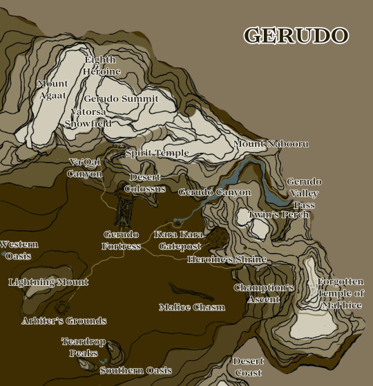
𖤓 Gerudo
Leader: King/Lord Ganondorf Dragmire
Allies: Tabantha Rito
Adversaries: Hyrule, Zora, Goron, Kokiri
Neutral: Hebra Rito
Triforce of Power/Vessel of Malice - Ganondorf | Sage of Spirit - Riar'svah
Locked in by towering mountains, the Gerudo desert is a harsh, near unlivable area. Despite this, a rich array of creatures, flora, and people dwell in the desert. Amidst Molduga, saffina, juicy melons, oases, and tangy fruits, the Gerudo people have amassed an empire. The Gerudo Fortress is a feat: built jutting out of the mountain at the foot of the Desert Colossus, with windcatchers using the winds from the Highlands to cool the fortress, the underground reservoir waters are pumped upwards to flow through the fortress. Mosaics, walls of glass and gems, and tapestries ordain the fortress with beauty. Their matrilineal and matriarchal society worship the Sand Goddess and spiritually venerate their ancestors through colossal statues, colosseums, and underground sanctuaries. Trading fabrics, gems, dyes, Molduga parts, and gold, the Gerudo are wealthy and sovereign. A male is born once every 100 years, the current one on the throne, overseeing their three part government: king/chief, spiritual priestess, and magic elders.

𐦍 Rito
Tabantha:
Leader: Komilli & Needeema
Allies: Gerudo
Adversaries: Hebra Rito
Neutral: Hyrule
Sage of Wind | Komilli
Tabantha is a rich area of sloping plains, tall grass, and a gradual fade into cold, windy mountains, dense with snow. The Tabantha Rito tribe live in the northwest pocket of the region, specifically on the bird-shaped island in Medhoh Lake. There, they thrive in the towering ivory and stone structure, creating expert bows, arrows, wheat and grain products, and woven/braided material. They trade little with Hyrule, usually in exchange for foodstuffs. These Rito are tactical archers and woodwind musicians, famous for their lullabies and melodies heard echoing across Tabantha's frontier. In the Rito divide, the Tabantha coveted the Wind Temple, a towering structure nestled away in the mountains where the wind howls relentlessly, buffeting all who come near. This temple is their sacred place, challenging young Rito to brave the tormenting winds to reach it and leave offerings to the mysterious half-Rito, half-Hylian there, simply named Wind Player. The Sage of Wind, Komilli, turns his back on Hyrule when the war starts and his fellow leader, Needeema agrees, making the Tabantha Rito a neutral party...mostly. Komilli receives a vision and flies into the Gerudo Highlands where he meets with the Gerudo Sage... a deal was struck, that's all many know.
Hebra:
Leader: Edeeri
Perilous drops, slick ice, and thick snow loom over the dry, windy tundras of Hebra. Isolated, adversarial, and unwelcome, the Hebra Rito tribe are hostile to all who cross their lands, flying high above to spot and dive bomb intruders. Their hostility is unknown in origin but their callousness is not out of a violent inclination rather a desire to be left alone, safe, and separate from the divine back and forth in Hyrule proper. Since they engage in no trade or official communications, not much is known about the Hebra Rito save for a few stories and ideas. Their arrows are crafted of stone and lumber, with feathers plucked from the tail feathers of their user. They worship no god or goddess and their leader, seen in glimpses so brief many wonder is she is real, is Edeeri, an all-black Rito near twice the size of her companions.
𖧧 Woodlands / Lost Woods
The Kokiri and the Lost Woods inhabitants are non affiliated, choosing to remain in their shrouded depths of gnarled roots, misty meadows, endless lakes, and the shade of the Great Deku Tree. Tatu, the keeper of the Master Sword, is the only Kokiri who graces Hyrule, citing a divine calling to reach out and aid in the incoming rise of the Demon King.
#loz#legend of zelda#loz original#legend of zelda original#loz oc#legend of zelda oc#zelda#link#zora#goron#hylian#sheikah#kokiri#gerudo#ganondorf dragmire#ganondorf#gerudo oc#worldbuilding#hyrule worldbuilding#go zero notes go!!#I LOVE CULTURE AND GEOGRAPHY BUILDING#this map took me forever send help#loz ternary ages
49 notes
·
View notes
Text
hard mode.
everyone's doing this so i wanted to join in with my favorite geography quiz <3 countries of the world but you fill in the map as you go
#good luck!#NOTE: this quiz IS a bit shitty in that it does not have palestine.#poll#cricket chirps#countries quiz#geography
116 notes
·
View notes
Text


Late night study session feat. Geography.
|Did I spend 15 minutes trying to get these photos instead of studying? Yes, yes I did.|
#student#study#study aesthetic#study motivation#study notes#studyblr#studymotivation#studyspo#book#finals#geography
27 notes
·
View notes
Text
it is funny learning that people use scenepacks to make edits and stuff bc if anyone ever asks me what ones i used for my utena edits i'll have no answer besides my uber autism making me know exactly which episode the scene i want came from
#when i make an amv or edit that shit comes to me in a vision#i plan out exactly what scene goes with which lyric. and then i go and hunt down each scene on the internet archive + screen record it#i dont need scenepacks i just got all this shit in my head instead of remembering something useful#i cant memorize my geography notes but i can tell you which episode a specific frame/scene is from#you also know its bad bc ive only watched this show like.. 2.75 times in full. and yet.#(i say 2.75 bc im on my 3rd rewatch. and also because certain episodes i have seen multiple times)#rgu
37 notes
·
View notes
Text
Putting both hands over my mouth (Chapter 4)
Tim actually calls Jon instead of texting and is grateful when he answers on the first ring.
There’s an interrupted laugh in his voice when he says, “Hey Tim!”
It’s followed almost immediately by, “Do not throw pancake scraps at me! Give them to the chickens!”
There’s a pause and then Jon clears his throat. “What’s up?”
“You should get back to Metropolis,” Tim says, and is truly shocked how stable and together his voice sounds. “You should go talk to Damian, and if he tries to keep you out again, you should break down his door.”
“Are you okay?” Jon asks instantly.
So perhaps less stable than he’d thought.
“I believe I just became a starring member of my little brother’s rogues gallery,” Tim replies.
Well. That’s not true. It’s not just now.
“Uh…” Jon says, and Tim can hear the frown. “Is… Damian okay?”
“No,” Tim says promptly. And then realises he has to clarify. “Physically he’s probably fine. Emotionally, uh.”
#jondami#timkon#tim drake#jon kent#damian wayne#conner kent#kon-el#dc#the ghost ship scribbles#sorry for being insane about dc geography in the authors note it will happen again
102 notes
·
View notes
Text
At a certain point blaming the school system for failing to teach you every fact becomes an excuse to absolve yourself from learning on your own time as an adult. Maybe you had bad teachers and curricula, maybe you never did the assigned reading, maybe you were taught propaganda, but it’s okay to start now. It’s okay to learn geography from online games. It’s okay to get entry level books from the library on a subject. It’s okay to explore Wikipedia and other reputable websites as a start. You can learn as an adult. You should continue learning as an adult.
#If I see one more post blaming the school system for people not knowing things that are either - basic and they didn’t retain or -niche and#not something that would have been relevant for most curriculums I’m gonna lose it#so you’re bad at geography ??? TRY. there are GAMES#don’t know history??? there are so many resources in different formats and access levels#bc of 2020 there are so many college lectures recorded on YouTube you can watch#there are daily games you can play to slowly learn#you don’t need to ADVERTISE your ignorance of things either#predicting that the notes on this will be annoyin#also there are many valid critiques of Wikipedia but at least it cites its sources which is more than most ‘educational’ tiktoks
70 notes
·
View notes
Text


Odd productivity from this week. For the UNESCO project I'm a part of, I'm now the official cartographer, go figure ☆ Drawing a huge diner scene lately, which apparently I have plenty of time for without internet in my new place. Yesterday I fingerpainted 😅 I've been doing all my work on the bus and tram wifi 😑 I'm too cheap to pay for a café and the local library is a loud community center so it's really my commuter card that will get a special mention in any publications. 🙏
#my art#digital art#studyblr#study blog#gradblr#researchers#geography#my wips#messy notes#light academia#food#denmark
57 notes
·
View notes
Text


04|06|2025
first exam done!! i think i did pretty well on it but the short story question hello??? none of our third year classes did a short story but i answered with a novel and my teacher said it’s okay so i think im safe. now all im really scared about for this week is irish (it’s tomorrow im gonna kms) and maths because i know ill do horrible on the listening. to ignore those fears, this is what i studied today -
📚i started with a few spás exam questions and rewrote the plot, theme, ending and character notes.
📚then i moved onto a few daideo past exam questions and rewrote small notes on some important vocabulary.
📚after a small break i worked on a bit of jeaic ar scoil by completing two exam questions about the images and emotions seen in the poem.
📚to wrap up the evening, i did some quick revision on old geography notes as im fairly confident with this subject.
praying for no drama on this irish exam bc i did not study ghleann álainn and no migration questions for the geography exam.
🧿🪬🧿🪬🧿🪬
#exam season#exampreparation#homework#ireland#junior cert#leaving cert#school work#study#study aesthetic#study blog#quotes#revision#irish#poetry#study inspiration#study notes#studyblr#studyspo#study motivation#geography
20 notes
·
View notes
Text


About today ✨☀️
#study vibes#studyblr#geography#study#desk#motivation#uni#mine#study setup#studying#study aesthetic#study space#geo#desk aesthetic#wallpaper aesthetic#photography aesthetic#interior aesthetic#student life#study motivation#note taking#study inspo
77 notes
·
View notes
Text
researching underwear situation in the 70s america and journalistic slang for two lines in my wip but absolutely refusing to give ANY mapping out about where the fuck they are. it's a city. enough said
#honestly i can't care less#that one ao3 author note about english not being my first language and i don't want it to be#only it's me with precise american geography#thoughts in words
10 notes
·
View notes