#imaginary map
Explore tagged Tumblr posts
Visit Tumblr Blog
Explore Tumblr blogs with no restrictions, modern design and the best experience.
Last Seen Tumblr Blogs


Fun Fact
1,644 Tumblr posts in 1 second.
Text

Map of New Imihama Bay, the setting of our Mutants & Masterminds campaign. This old industrial town has a mix of German and Japanese culture, with a bit of other places sprinkled in.
#map#imaginary map#worldbuilding#game map#ttrpg#mutants and masterminds#mutants & masterminds#inkscape#vector art#digital art#new imihama bay#smzz#swirly magic: zimt & zucker#zimt und zucker#zimt & zucker
15 notes
·
View notes
Text
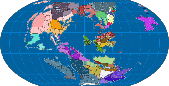
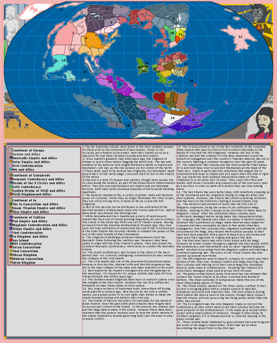
Map of my current fantasy world, Theia. The one on the top is an updated version of the map with some improved borders, bottom is a more outdated version of the map, but with accompanying lore, though I'll fully update everything in the future. Main premise is that the world is undergoing a cold war between major mago-industrial powers with one story I'm working on taking place within the Io Consortium, which is an unstable megacorporate state being fought over by the Demonic Confederacy and the Avalonian Empire.
11 notes
·
View notes
Text
youtube
This video showcases my Blender model of the planet that the Scud aliens call home, the fourth and final world I've mapped out for @jayrockin's "Runaway to the Stars" project. A *lot* of maps were created in service of this final render, and also in service of presenting the special qualities of this planet. I intend to show you as many of these as I can under the cut, and also in subsequent posts focusing on some of the more interstitial, ancillary maps and figures that played a part in producing the primary maps you'll see in this main post.
Before I show the first maps I made for this project, what you see below are the satellite-style maps for the Equinoxes and Solstices, in order of (Northern) Spring, Summer, Fall, and Winter, the latter serving as the texture for the Blender object you saw in the video.


__________
With that matter covered, our next focus is this project's foundation: Geology. While I didn't spin as elaborate a tectonic history for this planet as I did for the Ayrum commission, I did work out as much detail as I could for the more recent geological activity, to set the stage for the elevation data - including a narrower focus on the coastal shallows that host the Scud populations.


__________
Once I could move on to climate, my first step was finding this planet's relative Insolation, which I managed thanks to @reversedumbrella's code and coaching. With an obliquity of only 16 degrees, this planet's yearly maximum Insolation levels stick close to the equator, compared to pole-to-pole oscillation we see on Earth

__________
Having a rough sense of where heat would concentrate seasonally and how the landmasses would deflect water in light of the planet's retrograde spin, I was able to set down the bi-annual ocean currents (Northern Summer above and Northern Winter below), then the monthly water temperatures pushed around by said currents, and finally -after factoring in many other considerations- the monthly land temperatures as well (combined in the second gif)


__________
Next came the seasonal air pressure maps and subsequent wind patterns (my first time creating those from scratch), which later factored into the precipitation maps. The incredible temperatures at the largest continent's interior make a desert of most of it, and the other interiors are fairly dry too, but all that heat on the equatorial ocean generates a *lot* of evaporation which ends up coming down elsewhere.


__________
With temperatures and precipitation mapped out for each month, I was able to find how the accumulation and melt of ice and snow played out, too. Given such a hot equator it's surprising to see freezing temperatures hold out in some places, but low obliquity and high elevation shield what areas they can, it seems.


__________
All this monthly data was then painstakingly combined and compared and plugged into equations to produce maps of discrete climate zones, using both the Köppen (left) and Trewartha (right) classification systems. The higher latitudes see some overlap with Earth's conditions, but the Tropics...


__________
I never really finished the map I wanted to make with my own loosely customized classification system, but I *did* get as far as this breakdown of the areas that sometimes surpass 56.7 degrees Celsius, Earth's record for highest surface temperature ever directly measured. And as you can see, that earthly record is broken by a *significant* fraction of this planet's surface, and far exceeded by the equatorial continent's deep interior

__________
The final phase of this project dealt with creating satellite maps of this planet's surface (which you saw at the top of this post), which started with a map of dry and submerged substrate, then a density map of the vegetation that sits atop it, then the colors of that vegetation under annual average conditions (demonstrating how they would appear in-person, rather than the area's appearance from orbit), and finally plant colors under seasonal conditions (same conceit as previous). In concert with the seasonal ice and snow maps, it was the four maps in the last sequence which were overlaid on the Substrate map, using the plant density map as raster masks, to produce the final Satellite-Style maps.


__________
This planet's sophonts being a marine species, it was then worth focusing on the conditions underwater, which included monthly seafloor temperatures (first gif), annual discharge of sediment from rivers (magenta in the 2nd gif), and seasonal upwelling of nutrients from deeper water (blue in the 2nd gif).


The creation of all my maps seen in this post was possible thanks to Photopea, which has been my go-to for several years now. The resolution kinda got crunched when I uploaded these here, so when I share them on Reddit later I'll add those links under this. These have also already been posted on Twitter, which you can see here if you like. Thanks for scrolling all the way down here!
#digital painting#Photopea#digital 3d#Blender#mapmaking#imaginary maps#Runaway to the Stars#Rtts Scuds#speculative planetology#speculative geology#speculative climatology#alien planet#major post#commission#christopher maida artwork#Youtube
765 notes
·
View notes
Text
Map of the Solar System from Signalis

#signalis#maps#cartography#imaginary maps#mapmaking#worldbuilding#fallout#science fiction#scifi#scifiart#outer space#solar system#space
658 notes
·
View notes
Text
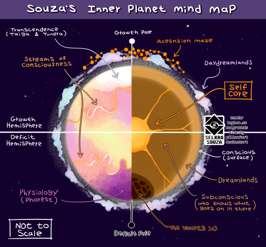
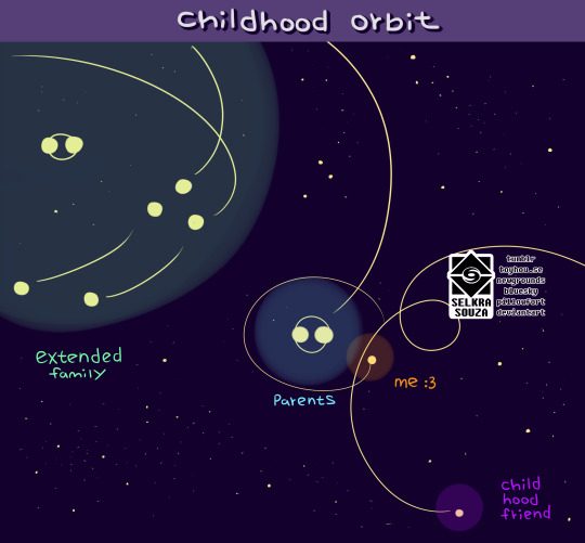
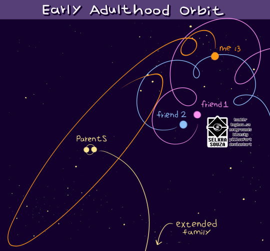
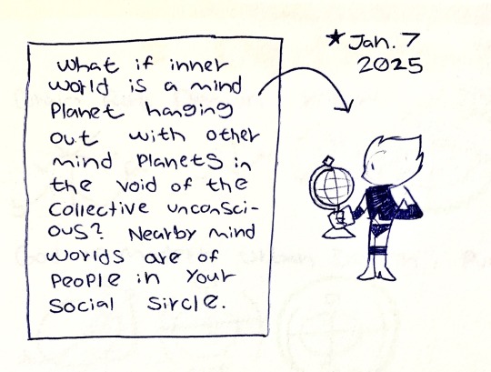
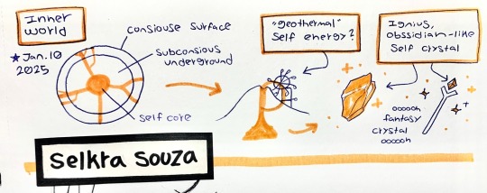
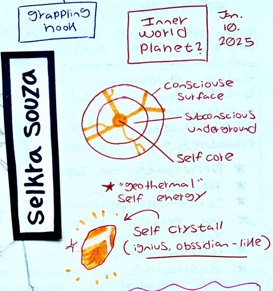
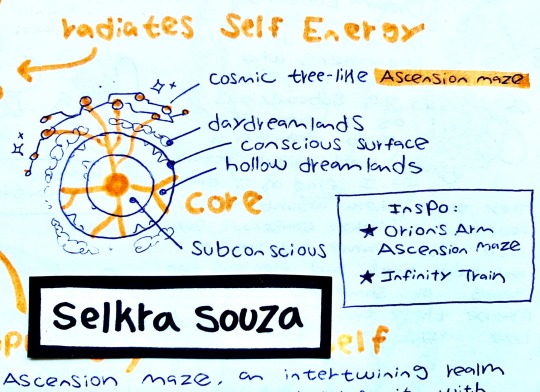
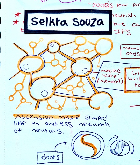
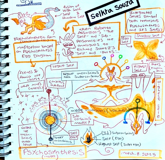

Reimagining the inner world as a planet moving around the void of the collective unconscious instead of as a landburg. Been scrambling between different psychoanalytic models for inspiration for different layers of the planet such as the atmosphere, geosphere, latitudes and orbiting bodies representing the inner worlds of my social circle. I mainly took inspiration from Carl Jung’s and Roberto Assagioli’s models.
#selkra scribbles#emotionsonas#inner world#headworld#paracosm#paragenic#paraportal#psychonautics#mind map#plurality#worldbuilding#world building#endogenic system#immersive daydreaming#immersive daydream#imagimancy#imaginary world#inside out fandom#inside out oc
72 notes
·
View notes
Text
About the entanglement of "science" and Empire. About geographic imaginaries. About how Empire appeals to and encourages children to participate in these scripts.
Was checking out this recent thing, from scavengedluxury's beloved series of posts looking at the archive of the Budapest Municipal Photography Company.
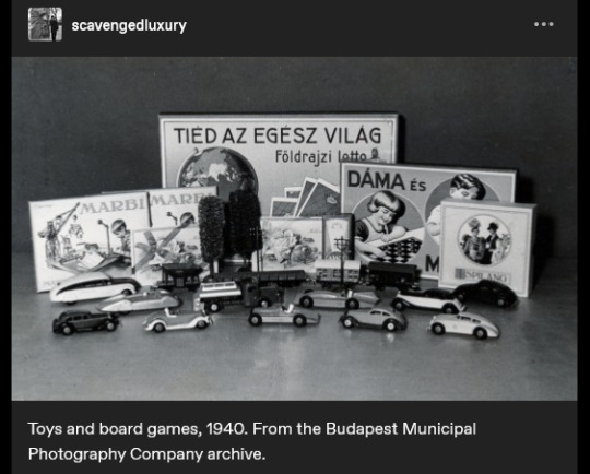
The caption reads: "Toys and board games, 1940."
And I think the text on the game-box in the back says something like "the whole world is yours", maybe?
(The use of appeals to science/progress in imperial narratives probably already well-known to many, especially for those familiar with Victorian era, Edwardian era, Gilded Age, early twentieth century, etc., in US and Europe.)
And was struck, because I had also recently gone looking through nemfrog's posts about the often-strange imagery of children's material in late nineteenth- and early twentieth-century US/Europe. And was disturbed/intrigued by this thing:
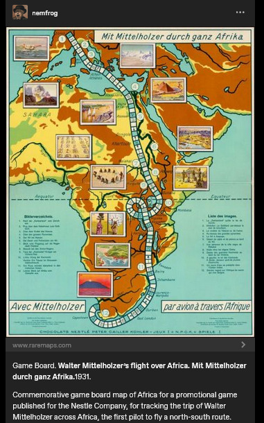
Caption here reads: "Game Board. Walter Mittelholzer's flight over Africa. [...] 1931. Commemorative game board map of Africa for a promotional game published for the N*stle Company, for tracking the trip of Walter Mittelholzer across Africa, the first pilot to fly a north-south route."
Hmm.
"Africa is for your consumption and pleasure! A special game celebrating German achievement, brought to you by the N*stle Company!"
1930s-era German national aspirations in Africa. A company which, in the preceding decade, had shifted focus to expand its cacao production (which would be dependent on tropical plantations). Adventure, excitement, knowledge, science, engineering prowess, etc. For kids!
Another, from a couple decades earlier, this time British.
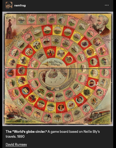
Caption reads: "The "World's globe circler." A game board based on Nellie Bly's travels. 1890." At center, a trumpet, and a proclamation: "ALL RECORDS BROKEN".
Same year that the United States "closed the frontier" and conquered "the Wild West" (the massacre at Wounded Knee happened in December 1890). A couple years later, the US annexed Hawai'i; by decade's end, the US military was in both Cuba and the Philippines. The Scramble for Africa was taking place. At the time, Britain especially already had a culture of "travel writing" or "travel fiction" or whatever we want to call it, wherein domestic residents of the metropole back home could read about travel, tourism, expeditions, adventures, etc. on the peripheries of the Empire. Concurrent with the advent of popular novels, magazines, mass-market print media, etc. Intrepid explorers rescuing Indigenous peoples from their own backwardness. Many tales of exotic allure set in South Asia. Heroic white hunters taking down scary tigers. Elegant Englishwomen sipping tea in the shade of an umbrella, giggling at the elephants, the local customs, the strange sights. Orientalism, tropicality, othering.
I'd lately been looking at a lot of work on race/racism and imperative-of-empire in British scientific and pop-sci literature, especially involving South and Southeast Asia. (From scholars like Varun Sharma, Rohan Deb Roy, Ezra Rashkow, Jonathan Saha, Pratik Chakrabarti.) But I'd also lately been looking at Mashid Mayar's work, which I think closely suits this kinda thing with the board games. Some of her publications:
"From Tools to Toys: American Dissected Maps and Geographic Knowledge at the Turn of the Twentieth Century". In: Knowledge Landscapes North America, edited by Kloeckner et al., 2016.
"What on Earth! Slated Globes, School Geography and Imperial Pedagogy". European Journal of American Studies 16, number 3, Summer 2020.
Citizens and Rulers of the World: The American Child and the Cartographic Pedagogies of Empire, 2022.
Discussing her book, Mayar was interviewed by LA Review of Books in 2022. She says:
[Quote.] Growing up at the turn of the 20th century, for many American children, also meant learning to view the world through the lens of "home geography." [...] [T]hey inevitably responded to the transnational whims of an empire that had stretched its dominion across the globe [recent forays into Panama, Cuba, Hawai'i, the Philippines] [...]. [W]hite, well-to-do, literate American children [...] learned how to identify and imagine “homes” on the map of the world. [...] [T]he cognitive maps children developed, to which we have access through the scant archival records they left behind (i.e., geographical puzzles they designed and printed in juvenile periodicals) [...] mixed nativism and the logic of colonization with playful, appropriative scalar confusion, and an intimate, often unquestioned sense of belonging to the global expanse of an empire [...]. Dissected maps - that is, maps mounted on cardboard or wood and then cut into smaller pieces that children were to put back together - are a generative example of the ways imperial pedagogy [...] found its place outside formal education, in children's lives outside the classroom. [...] [W]ell before having been adopted as playthings in the United States, dissected maps had been designed to entertain and teach the children of King George III about the global spatial affairs of the British Empire. […] [J]uvenile periodicals of the time printed child-made geographical puzzles [...]. [I]t was their assumption that "(un)charted," non-American spaces (both inside and outside the national borders) sought legibility as potential homes, [...] and that, if they did not do so, they were bound to recede into ruin/"savagery," meaning that it would become the colonizers' responsibility/burden to "restore" them [...]. [E]mpires learn from and owe to childhood in their attempts at survival and growth over generations [...]. [These] "multigenerational power constellations" [...] survived, by making accessible pedagogical scripts that children of the white and wealthy could learn from and appropriate as times changed [...]. [End quote.] Source: Words of Mashid Mayar, as transcribed in an interviewed conducted and published by M. Buna. "Children's Maps of the American Empire: A Conversation with Mashid Mayar". LA Review of Books. 11 July 2022.
Some other stuff I was recently looking at, specifically about European (especially German) geographic imaginaries of globe-as-playground:
The Play World: Toys, Texts, and the Transatlantic German Childhood (Patricia Anne Simpson, 2020) /// "19th-Century Board Game Offers a Tour of the German Colonies" (Sarah Zabrodski, 2016) /// Advertising Empire: Race and Visual Culture in Imperial Germany (David Ciarlo, 2011) /// Learning Empire: Globalization and the German Quest for World Status, 1875-1919 (Erik Grimmer-Solem, 2019) /// “Ruling Africa: Science as Sovereignty in the German Colonial Empire and Its Aftermath” (Andrew Zimmerman. In: German Colonialism in a Global Age, 2014) /// "Exotic Education: Writing Empire for German Boys and Girls, 1884-1914". (Jeffrey Bowersox. In: German Colonialism and National Identity, 2017) /// Raising Germans in the Age of Empire: Youth and Colonial Culture, 1871-1914 (Jeff Bowersox, 2013) /// "[Translation:] (Educating Modernism: A Trade-Specific Portrait of the German Toy Industry in the Developing Mass-Market Society)" (Heike Hoffmann, PhD dissertation, Tubingen, 2000) /// Home and Harem: Nature, Gender, Empire, and the Cultures of Travel (Inderpal Grewal, 1996) /// "'Le rix d'Indochine' at the French Table: Representation of Food, Race and the Vietnamese in a Colonial-Era Board Game" (Elizabeth Collins, 2021) /// "The Beast in a Box: Playing with Empire in Early Nineteenth-Century Britain" (Romita Ray, 2006) /// Playing Oppression: The Legacy of Conquest and Empire in Colonialist Board Games (Mary Flanagan and Mikael Jakobsson, 2023)
#mashid mayar book is useful also the Playing Oppression book is open access online if you want#in her article on slated globes mayar also mentions how european maps by 1890s provoked a sort of replete homogenous filling in of globe#where european metropole thought of itself as having sufficiently mapped the planet by now knit into neat web of interimperial trade#and so european apparent knowledge of globe provided apparently enlightened position of educating or subjugating the masses#whereas US at time was more interested in remapping at their discretion#a thing which relates to what we were talking about in posts earlier today where elizabeth deloughrey describes twentieth century US#and its aerial photographic and satellite perspectives especially of Oceania and Pacific as if it now understood the totality of the planet#ecologies#tidalectics#geographic imaginaries#mashid mayar#indigenous pedagogies#black methodologies#tigers and elephans#victorian and edwardian popular culture#my writing i guess
141 notes
·
View notes
Text
Actually, the really crazy thing is how @siena-sevenwits sent me a title and the concept "people disagree about whether it counts as fantasy" and it turned into a book that does not exist, but has become part of the bedrock of my worldview.
It's not that I built it out of any deep philosophical musings or anything. I just found the story concept, and it turns out that it relates to everything.
#cardinal's map#imaginary book recs#the fact that cardinal's map doesn't exist makes it especially fitting#that it's about an imaginary book that changes someone's worldview#i still regularly have the urge to reread it#i've almost convinced myself that it's something i read years ago and want to buy for my shelf
28 notes
·
View notes
Note
what do you think about the newest penacony story patch in hsr?
penacony numero uno. actually the best arc out of the 3 so far but sunday should kill himself*
#*i cant beat the boss what else is fuckinggggg new 🚬#im typing this after my idk 4-6th attempt#the fact that you cant do the world level thing like you can in genshin is ass#bailus healing annoys me and gallagher...is actually pretty good for the fight i was worried taking him in but he does p well#i hate complaining about the difficulty of the game cause the reality is that im just not a stats guy and only vaguely understand how#everything goes. im better at an open world beat the shit outta everything game like genshin but i like sr more </3#and theres so few imaginary characters. DIE#aventurine and luocha were really good but either didnt care or was saving for someone else and im paying the PRICE#asks#anon#anyways ueah penacony fire story. gallagher and misha u are the world 🫶🏾#also it just looks really good all the maps are so nice looking#the characters are enjoyable i like how everyone plays a part and i actually cared about the story#star rail spoilers#b4 i got to the part ingame i saw mishas va on twitter give a lil thank you and i was like hes deeefinitely dying lmaoo#it was a nice ending for those 2 though bittersweet. im glad misha did get to experience the astral express even if it wasnt the one we kne#mhy
39 notes
·
View notes
Text


Wanted to do a rift today :)
11 notes
·
View notes
Text

Updated my world's map
14 notes
·
View notes
Text
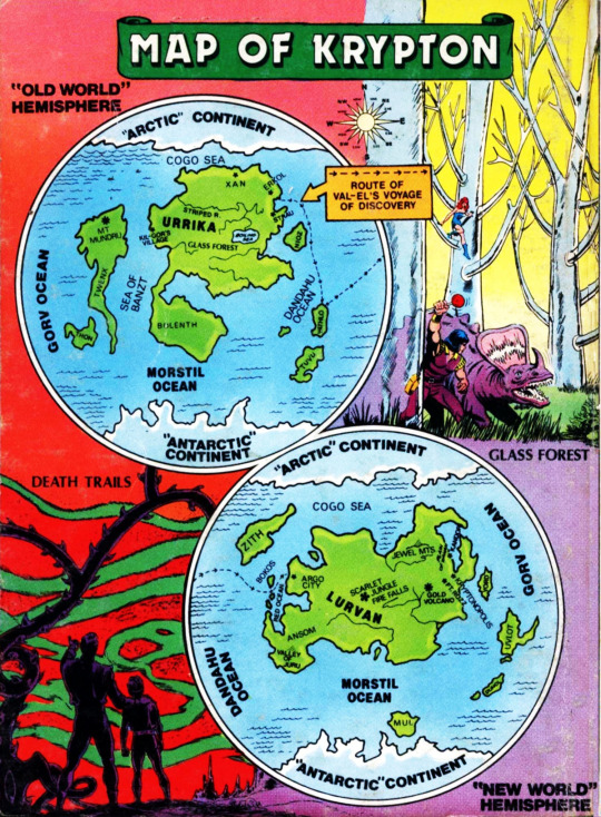
September 1983. Although not credited in the digest on whose cover this version was published (BEST OF DC #40, SUPERMAN: THE FABULOUS WORLD OF KRYPTON), this map of Krypton was drawn by Albert de Guzman and originally appeared in THE KRYPTON CHRONICLES #2 (October 1981). Many of the locales shown on the map had appeared in previous Superman stories, in particular the Scarlet Jungle.
A different map of Krypton, drawn by Howard Bender and Joe DelBeato, appeared in the Krypton entry in WHO'S WHO about three years later:

This version of the map is broadly similar to the De Guzman map above, although the captions for Kandor and Argo City seem to have been transposed: The vignette identified as Kandor appears to be Argo City — Argo had an environmental dome (which is how it survived the destruction of Krypton), while Kandor did not — and the vignette identified as Argo City looks a lot more like Kandor. My guess that someone switched the captions during production, seeing the dome over Argo and mistakenly assuming someone had mislabeled Kandor (which of course is best known as the Bottle City of Kandor).
#comics#best of dc blue ribbon digest#the fabulous world of krypton#albert de guzman#maps#krypton#kandor#kryptonopolis#argo city#superman#i love these maps of imaginary places#who's who also has maps of thanagar and rann#there was a more detailed map of rann in amazing world of dc comics in the '70s#which unfortunately is rife with errors#when compared to the stories it references
92 notes
·
View notes
Text

#brotherhood of steel#fallout 4#imaginary maps#ss2#sims settlements 2#map#battlemap#logistics#fo4#minutemen#railroad#spoilers#modded#fanfiction#sole survivor#jake evans
17 notes
·
View notes
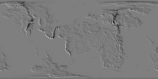
Text
I finally got around to compiling some of the extraneous, in-service-of-the-main-feature maps for the "Runaway to the Stars" Scud-planet commission that I thought were also worth showing, some because they reveal something unique about this planet's qualities, others because they're pretty, and mostly both. There's a good handful of those and a *lot* of explanatory text, so that's all below the cut.
First we have the maps that bridge the gap between wind data and precipitation. This pair of animated maps demonstrates, first, the Orographic effect that would theoretically result from winds blowing in each of the eight cardinal directions across the planet's whole surface, and, second, the Orographic effects which are actually produced by the local prevailing winds for each season. For both of these, darker values mark where the topography prevents moist air from precipitating (a rain shadow, on the leeward side of a raised terrain feature) and lighter values show where the topography catches most of the airborne moisture before the wind blows over it (a rain-highlight, on the windward side of a raised feature).
__________
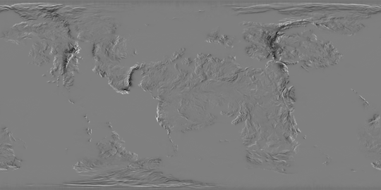
The first static map, looking like a meticulously customized Jawbreaker, roughly represents the inland distance over which air has to travel from various bodies of water (also accounting for vertical distance in the form of mountains and the sizes of the bodies of water providing the moist air), which is another factor in where rain is able to fall.
__________
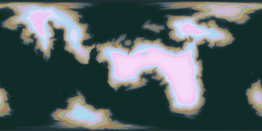
Another static map, included entirely for aesthetic reasons, demonstrates (in white) where at least ten times as much rain falls in the wettest month of summer as in the driest month of winter. The cyan end of the gradient represents where only 3 times as much rain falls, in that comparison. This was a step in figuring out what areas would qualify as Dry Winter (climate type Cw) in the climate zone maps, which ended up being completely nonexistent once all the other requirements of that climate type were measured for. All of the areas marked in white (meeting that 10x ratio requirement for Dry Winter) ended up falling under Arid or Semiarid instead.
__________
For comparison, *this* map shows (in cyan through magenta) where there is at least three times as much precipitation in the wettest month of winter as in the driest month of summer, one of the requirements for Mediterranean climate (or Dry Summer, climate type Cs). Not all of the marked areas ended up meeting all requirements for the final climate zone map, either, but at least *some* did, falling just outside the Arid/Semiarid areas.

__________
Another precipitation-related map, this one instrumental in figuring out vegetation density, demonstrates the reliability of significant rainfall. Specifically, this represents how many months in a row a given area receives at least 60 millimeters of precipitation per month, with areas in white receiving this amount for every month of the year, areas in black experiencing no months with that much rainfall, and shades of grey showing where this much rainfall persists for anywhere from one to eleven months in a row. The second map attached here shows that data broken down for the exact number of months.
__________
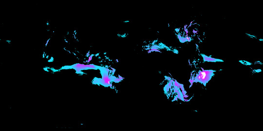
Next, here is a map that helped me find where Upwelling would occur seasonally. Since material from deeper waters is brought to the surface by the general movement of water *away from* the coasts, and since water is moved in that direction by winds blowing *perpendicular to* the coasts (counterclockwise for the northern hemisphere on a retrograde-spin planet like this, and clockwise for its southern hemisphere), it was crucial that I first determine what directions the coasts themselves were facing, with red marking coasts that face north, yellow for coasts that face west, cyan for coasts facing south, and blue for those facing east. This particular map was produced by taking a blurred elevation map of the shallows, using it as the displacement texture for a flat Plane in Blender, and pointing different colored lights at it from the eight cardinal directions.
__________
One of the very last elements that I mapped out for this planet was the discharge of sediments from the rivers into seas and terminal lakes, which required a *lot* of steps. The first of these was to isolate the different major drainage basins that would deliver water to various sections of the coastal shallows, as seen in the first, multicolored map. In the second map, we see the surface areas of each of the drainage basins, in the third map we see the average density of vegetation within each basin, and in the final map I've combined this data to show the overall total amount of vegetation in each basin, which should roughly correlate with how much organic material ends up washing out to sea, since river discharge volume and vegetation density are both (largely) contingent on the same factor: precipitation.

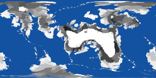

All told this is only a tiny fraction of the maps that were part of the overall pipeline. On Reddit you should be able to see these images in higher resolution, so I'm including a link to the corresponding post here
#digital painting#Photopea#mapmaking#imaginary maps#Blender#speculative climatology#Runaway to the Stars#RttS Scuds#alien planet#major post#commission#christopher maida artwork
17 notes
·
View notes
Text
Map of Cyrodill from the Elder Scrolls IV: Oblivion

#oblivion#maps#imaginary maps#mapmaking#cartography#digital illustration#the elder scrolls#tes fanart#elder scrolls
315 notes
·
View notes
Text

Alien Star System Chart Digital artwork by me, 2024
#art#artists on tumblr#artwork#digitalart#scifi#scifi art#science fiction#cartography#star system#map#star chart#chart#alien#alien worlds#map art#imaginary maps
5 notes
·
View notes
Text
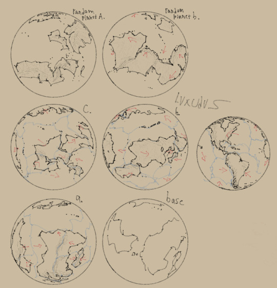
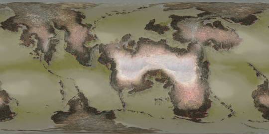
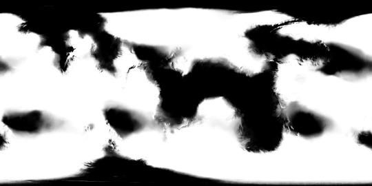
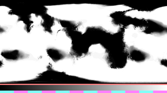
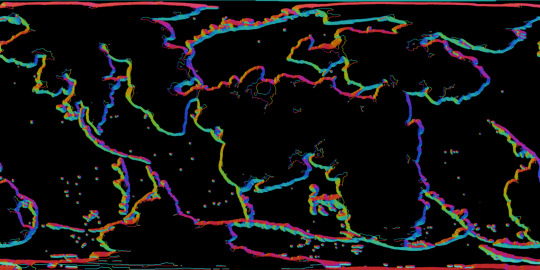
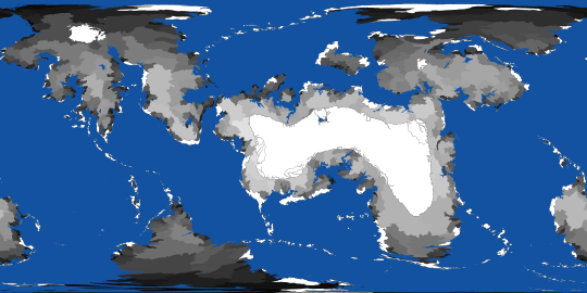
Ey dont worry everyone the Neo-Anthropocene isn't dead (yet) I still have plenty of ideas on where to take this project. For awhile now i've been feeling like the og map of Irou, the homeplanet of my main species atm: the Ikleud. No longer feels that natural or detailed.
Above are mostly concepts of an Irou with more realistic looking coastlines and more interesting continent shapes. The main ideas I've had for a long while is that all the landmasses were conjoined into a single northern super continent that broke up around either 150-100 mya or 300-250 mya. And that most of Irou's continents are arranged horizontally instead of vertically to differentiate it more from earth.
The top two planets however don't have anything to do with Irou and were just coastline warmups. Though random planet A. could look good for those neurodivergent posthumans, the Savunato. who's actual lore dump is still in the works.
Also i used this guide to make these coastlines and is the main reason i wanna get back into remaking Irou. :)
#my art#art#artist on tumblr#worldbuilding#alien planets#planet#fictional map#imaginary maps#neo-anthropocene
13 notes
·
View notes