#fictional map
Explore tagged Tumblr posts
Visit Tumblr Blog
Explore Tumblr blogs with no restrictions, modern design and the best experience.
Last Seen Tumblr Blogs


Fun Fact
In 2020, 44% of users from Denmark used Tumblr daily.
Text
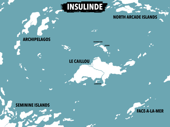
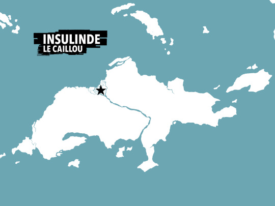
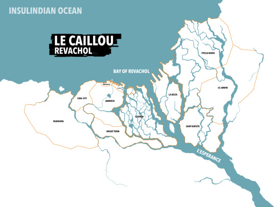
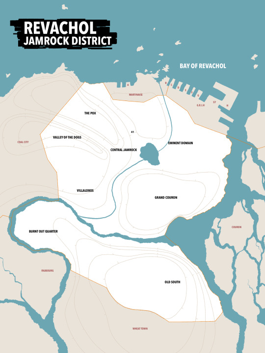
Re-Re-Re-mapping Revachol
… and the Insulinde as a whole
Very much inspired by ssshiversss and Map Max, whose versions of the map were absolutely invaluable for wrapping my head around this project. Combining their work with the original map of Jamrock, and doing my best to stay loyal to the (often contradictory) descriptions in the text of the game, I think I’m happy with what I’ve ended up with.
Much like my predecessors, I have elected to separate Coal City and La Delta, and in fact ignore any attempt by the game to convince me that La Delta is west of Martinaise. It just… It just isn’t.
Game description struggles aside, this was really fun!! Details/Description in the alt text.

I just like maps
EDIT // L’Insulinde: Now with Pale encroachment

#disco elysium#harry du bois#fictional map#revachol#jamrock#i love maps so god damn much#still unsure of so many things BUT WE DID OUR BEST AND THATS WHAT MATTERS#MWAH MWAH#LOVE FROM REVACHOL#FROM THE HILLS OF LE JARDIN TO THE GHETTOS OF FAUBOURG#i still dont know what The Cycle was supposed to be#DEVS WHAT IS THE CYCLE#LE CYCLE#YOU CAN’T JUST WRITE WORDS ON A MAP WITHOUT ANY INDICATION#OR DO RANDOM COLOURED LINES WITHOUT A LEGEND#beefing with a fictional map fr fr#anyway
261 notes
·
View notes
Text
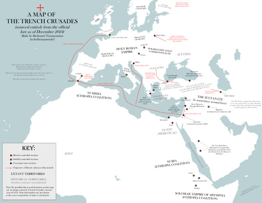
Map of Trench Crusade's Earth, featuring canon details mentioned from the Official Discord.
By reddit user u/Deditranspotashy
80 notes
·
View notes
Text
Map Of Whickber Street (Good Omens Soho around the bookshop)
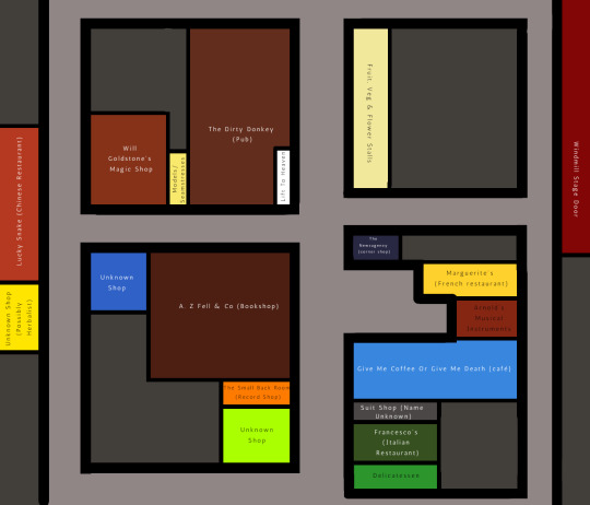
I had a lot of fun watching the entire series again and working out where all the shops were in relation to one another. Some of these are mentioned in canon, some are just shown. I've taken some liberties with scale and the like. It wasn't clear which of these streets is Whickber Street, but I suppose there must be some mystery left in the world.
I'm adding some photo references and some more information about the various shops below the cut. If you can make out any more names, I'd love to know.
It's possible the deli is also part of Francesco's as they're both Italian, but there is a front door by the awning that could lead to the restaurant (not an unusual set up for Soho). Francesco's awning is the victim of Crowley's rainstorm.
Between Francesco's and Give Me Coffee is a shop selling formal menswear that I couldn't make out the name of.
Next to that is the coffee shop, Arnold's (the musical instruments shop), Marguerite's (the French restaurant), and newsagency (the news agents). We get a lovely shot of them from the upstairs of the bookshop (newsagents just barely visible).

Opposite them, we obviously have the bookshop itself and down from that, the record shop (which is called The Small Back Room, presumably in reference to having started at the back of Aziraphale's bookshop). The record shop is the orange shop you can see below. (There's also a clearer view of the newsagents).
The shop one down from the record shop is currently a question mark, but it does have a very bold colour scheme, and at one point we are a candelabra and a piece of fabric in the window display. I can't make out the name of this one either.
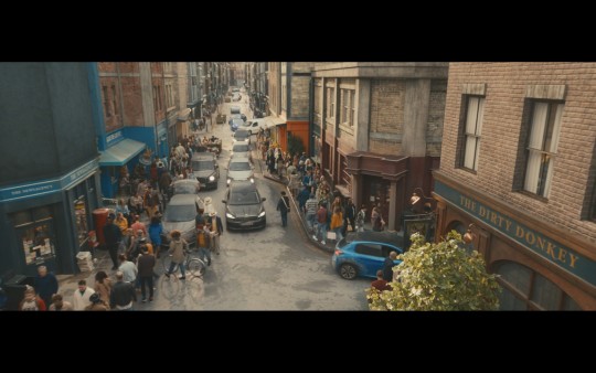
Opposite the bookshop we have the pub, the Dirty Donkey, whose front door is also the lift to heaven when summoned. Next to the pub is the doorway that leads you to the brothel (I picked the colour on the map from the new model friendly hands sign on the door), and next to that is Will Goldstone's Magic Shop. The magic shop, bookshop and the pub can also be seen in 1941 London flashbacks. Opposite the magic shop and next to the bookshop is another unknown shop. My gut says it sells lighting or maybe more general electrics, but I couldn't get a good enough shot to really see it.

At the end of this street we can see the Lucky Snake which I believe is a Chinese Restaurant, and just to the left we can glimpse a yellow shop, that I suspect is the herbalist that we see mentioned on Aziraphale's list of local businesses. Soho and Chinatown are geographical neighbours, and it's not uncommon to see Chinese herbalist or health shops in Soho. The red lanterns from the Lucky Snake continue down over the yellow shop, which is what gave me the impression it might be the herbalist.
Directly across the crossroads from the bookshop we have a fruit and vegetable market, that has a flower stand on the corner. That's where the tomatoes roll from when Gabe is walking through naked. (The veggies are obscured in the shot below, but we do see them in general)

If we follow the road between the flower market and the newsagents, I've extrapolated that the stage entrance to The Windmill (the theatre that we see in 1941) is there. We get a moderately clear view of it during the flashback, and the Windmill is a real place (to my knowledge it's somewhere between a burlesque club and a strip club these days), so I figured it would still be standing here too. We get the briefest of glimpses of the stage door still standing in modern London.
If you care for real world geography, then The Windmill's main entrance is on Great Windmill Street, right off Shaftesbury Avenue, on the corner of Archer Street.
I could not for the life of me find Brown's World of Carpets anywhere. Maybe he's not even actually a local business. He seems the type to fake it.
Here's a view of the area from heaven.
#good omens#good omens spoilers#good omens writing reference#writing reference#neil gaiman#fictional map#the goodest of omens
508 notes
·
View notes
Text

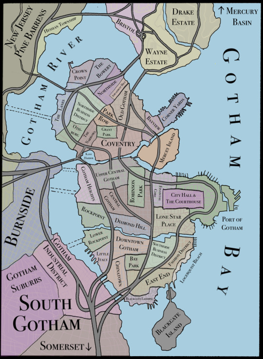
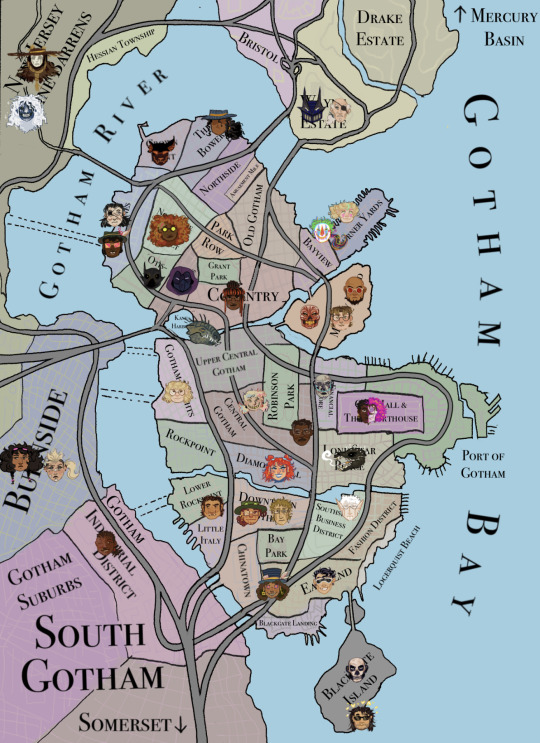
some maps of the gotham area for my au! disclaimers: heavily referenced off of the classic gotham no man's land map by eliot brown; i know NOTHING about city planning so all of the freeways/major roads are complete bullshit i made up. if you know more about city planning than me (likely) please be nice. my version of gotham (as made obvious by the inclusion of pine barrens) is located on a fictional part of the new jersey coast. i envision it to be slightly above delaware bay (which is also a classic gotham location, but i wanted to take some more liberties). i omitted some characters from the map who either don't have a permanent base of operation or who operate exclusively underground without a consistent entrance/exit point (or who were just too numerous to include. there are like 7 robins operating out of the batcave). also, killer moth isn't in blackgate, he's just employed at the blackgate point lighthouse, which is a historical location and mostly unaffiliated with the prison. i sometimes reference zsasz as being in arkham, but there's kind of a legal custody battle happening over if he's criminally insane enough to be in arkham or if his violent crimes warrant a blackgate sentence. he has professional business as a hitman in blackgate, so that's where i placed him.
43 notes
·
View notes
Text
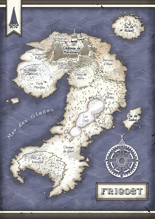
I'm so proud of this map ;w; Can't wait to receive it as posters!
#Frigost#dofus#wakfu#ankama#harebourg#count harebourg#fictional map#poster#merch#my art#comte harebourg
46 notes
·
View notes
Text

Map of Pop Star!!!!
This took like five hours and I almost lost the whole thing bc of a system crash so I hope you enjoy
22 notes
·
View notes
Text
I wanted to expand on the worldbuilding of In Stars and Time, and so far I have the basic landmasses and a few countries.
This map is based on a doodle I found by Insertdisc5 of the world of ISAT. I've taken the liberty of naming the Forgotten Island Sahaet, and of working on its language and history which you'll see more of soon. There is a much wider world map, but for now I'd like to focus on fleshing out what we see/hear about in the game.
If anyone's interested in doing some worldbuilding as well, feel free to expand upon what I make, or even submit your creations which may be integrated into this project.

29 notes
·
View notes
Text
So I'm reading Crimson Rivers right now and am wondering if there's any sort of canon info about where the districts are located. I'm a big fan of maps in literature, particularly in fantasy/dystopian settings, and would love to be able to visualize if there's a real-life land area that makes up their world. Like is it England? Great Britain? The UK as a whole? And within that, where are the district boundaries? What area makes up the Hallow? Like I've seen stuff that James, Reg, and Sirius are from District 6, Marlene is from District 11, and Remus and Lily are from District 12, but where are those districts in relation to each other and in relation to the Hallow?
If there's any canon info you can provide I'd appreciate it. Don't worry about spoilers as I've had several things spoiled for me already from interacting in fandom spaces. And if there's not anything canon, I'd love to hear fan theories!!!
#crimson rivers#the marauders#harry potter#jegulus#wolfstar#dorlene#james potter#regulus black#sirius black#remus lupin#dorcas meadowes#marlene mckinnon#lily evans#fictional map
24 notes
·
View notes
Text

The old Ahnāwi homeworld

The ancient Ahnāwi homeworld, lost after their final exodus, was a frozen super earth in orbit of a red gas giant. It had been captured into its orbit after a rogue planet had flung it further out system, causing the biggest mass extinction in the planet's history.
Before its fall, it was the center of Ahnāwi civilization. Despite having less people on it compared to the orbital swarm, it still carried great cultural significance and was where the capitals of multiple nations. While not united and fractured into multiple nations like humans, it had multiple international space hooks around it, allowing cheap and easy access into space.
It is unknown what happened to it after the Battle of the Fall, but it is suspected to have met the similar fate of major depopulation and becoming a preserve for a small population of Ahnāwi under the watch of the Decievers.
#my art#scifi art#lost suns#digital painting#map#fictional map#maps#planet#fictional planets#3d#blender3d
26 notes
·
View notes
Text


(I did NOT draw this-- this was created with a free, open-source fantasy map making program called Nortantis! Many thanks to the creators of it, this was a HUGE help in making this map which I otherwise struggled to create!)
--
SO THIS TOOK A WHILE WHAAHAH BUT HERE IT IS; a general map of Copper-9 in my bestial disassembly drone AU, Drones of the Desolate Arctic!!
By NO means is this geologically accurate or whatever the fuck, so pleaseee take it with a grain of salt-- but hey, at least Copper-9's got a map now, even if its nowhere near close to canon XD Besides, this is fiction, an AU of murderous 3000's robots, let's reject logic and just have fun -w-
IMPORTANT NOTE: Everything listed from the regions to the rivers had been named by the DD race, hence the uniqueness of the names and more primal based ones if that makes sense haha. What the worker drones would call the various locations can but up to viewers guesses for now until/if I decide to make names in regard to that.
--
Lore drop! Bit of a long read haha (Little changes made since past uploaded stuff)
Copper-9 is a massive snowy exoplanet far from Earth, roughly two times the size of Earth and dense with minerals, mostly copper, hence its name. It is always cold and snowy on this planet no matter the season, though summertime is notably less harsh and has less snowy weather or freezing cold temperatures than other season. The planet has flora and fauna highly similar to those on Earth, but with notable differences here and there alongside flora/fauna that is entirely alien and unique.
Humans came to the planet to collect Copper and other minerals present with the use of worker drones, creating five factories; one in each of the main regions; north, central, eastern, southern and western. However, following a major accident in the eastern factory, the human workers of that specific factory were all wiped out and said factory destroyed. With the safety concerns that followed, the humans of the other factories left the planet to return to Earth, leaving the factories and small human settlements left behind as well as the worker drones to the elements and assuming they'd die out.
When the knowledge came a few years later that the workers survived the humans abandoning them and were booming in numbers, they then started large scale production of disassembly drones to cull the population. When the first 'packs' of DDs were ready, they sent them to Copper-9, where they spread across the planet and formed territories, and fulfilled their purposes well in killing off worker drones, hundreds of workers being slain in the first months of their presence.
While plenty of workers stood their ground to protect their homes, a good number of the worker drones fled their settlements and found sanctuary in the northeastern island, a fair distance from the main continent. The distance is more than most DDs care to fly, and the mist that shrouds the island makes it hard for said drones to keep their bearings midair. As such, this hidden island has become a safe haven for the workers, and with their large scale population on that island, any DDs that do manage to find their way to the island don't make it back to the continent alive thanks to the workers banding together and creating various means of defense against their primal enemies. Besides basic residential settlements, various drones banded together to form the Worker Defense Force (WDF) and created various outposts across the island, specializing in all things defense and also generally watching out for danger from various vantages.
The DDs have large or small territories depending on two factors; one, the size of the pack (A couple with pups or a larger pack of mixed blood/etc) and the season (DDs aggressively expand their territory during late fall through winter, as to ensure they have prime hunting grounds and enough land to deter intruders). Most packs have a single large den, a communal den, at the center or 'home base' of their territory, also known as the territory heart, where the drones can mingle with each other and relax in between tasks. The drones of the pack may also have their own dens elsewhere in the territory where they call their personal home and raise pups.
Communal dens can be various things, from a series of underground tunnels to repurposed human/worker drone structures. Communal dens tend to include- but aren't generally limited to, as these areas can be anywhere in the territory- a medical area, nesting areas for mothers, denning areas for packmates, a larder for fresh forage/kill, the leaders' den, and a healer's area for the sick and injured.
For example of a communal den; Silvercrest's communal den is a large, somewhat ruined multi-wing building that once belonged to humans, then worker drones, before the ancestors of Silvercrest wiped out the workers there and claimed the building as their territory heart.
--
Next up, here's some extra details regarding the northern region of Copper-9, where Silvercrest (J's pack with N, V, and others) resides, with territories and also some worker settlements that didn't abandon the continent! Furthermore, the outpost and settlement locations on the worker drone safe haven island have been included as well!


Still got plenty of map-based things I gotta get to but this is all I've got for now lmao I need a break from the map stuff-- hope y'all like it!! This was lots of fun to do :> Hopefully there aren't too many typos or errors hidden in this sea of images or I will cry lmfao
#wolfieskies25#wolfie's art#Kinda? Not really? Cause I didn't draw it myself but still made it bwah#murder drones#murder drones au#md bestial#drones of the desolate arctic#Nortantis#reference sheet#fictional map
9 notes
·
View notes
Text
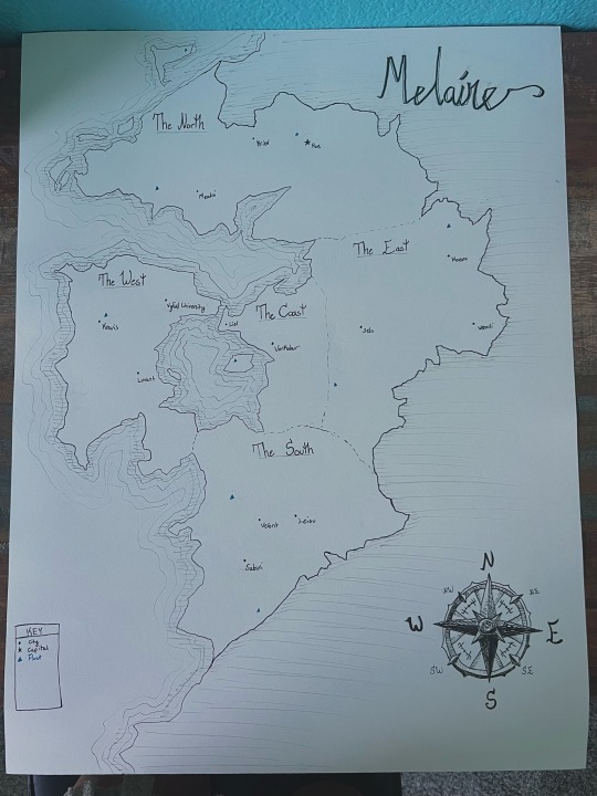

I made a map of Melaine on paper with water colour (which was something)
11 notes
·
View notes
Text

The Isles Eternal
D&D Map - The Isles Eternal
#The Isles Eternal#Map#fictional map#dnd map#d&d map#dnd#dungeons and dragons#dungeons and drawings#dnd art#art#artwork#my art#my artwork#original artwork#digital art#digital artwork#digital illustration#THoM#The House of Muses#The House of Muses Art
18 notes
·
View notes
Text
IVE FINALLY FINISHED IT!!! Pls don’t come after me, i know it might not be accurate to one specific book, bc i just copied the maps from the combined books
12 notes
·
View notes
Text
Titan, the largest land mass on Diatatus. This is a rough height map, and includes major rivers and ley lines.
#my art#bloom#fantasy maps#map making#fictional map#fantasy#its a good map!#theres a few issues but otherwise im happy with it#time to start drawing some animals that live continent-wide!
6 notes
·
View notes
Text
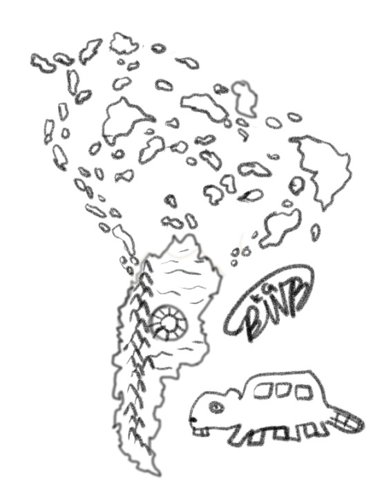
Had a dream the night before last night that felt like a sci-fi survival game with various bizzare animals, but what really stood out to me was the map. It was so vivid that I had to draw it. Along with one of the weird creatures that was in the dream (there were like, 5 different extremely bizarre species of beaver).
I had a map of south america as a guide since awake-me recognized the map to be shaped like it. I may revisit this sketch and further refine it cause I like the idea a lot (though I may rearrange the islands a little more since they aren't quite to the imagery from the dream). may even draw an actual scenic piece by the biodome cause it was also a fairly vivid image with an arid garden outside the dome along with sunken down zoo exhibits of very strange animals.
Thank bluesky cause thanks to it I'm trying to include alt text from here on now! really helps when you can toggle it so that it will only allow you to upload if you include alt text.
8 notes
·
View notes
Text

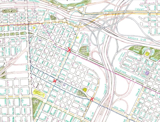
Stations #24 #25 #26: Tikal, Yaħyâ, Íñigo
Tikal station is located at Tikal Square which is at the intersection of Avinguda Catalunya, Calle Puerto, and Calle Rico. This would be like the central plaza in Latin American colonial towns and cities. It’s named after the Mayan ruins in northern Guatemala.
Yaħyâ (يحيى) Station is located where Calle Puerto and Calle Rico meet to create Calle San Juan at Mott Haven Road. There’s a mosque at the square named after the Prophet Yaħyâ (John the Baptist).
Íñigo station is located at Avinguda Catalunya and Bulevar Guatemala close to the park with the same name. I have always just really liked the name Íñigo so I kept the name for my city. I think it’s the double accent marks.
The lines that stop at Tikal station are:
- Buckeye East - Catalunya (light blue)
- Sarajevo - Latinoamérica (blue)
The lines that stop at Yaħyâ station are:
- Sarajevo - Latinoamérica (blue)
- Mott Haven - Columbus (bronze)
The lines that stop at Íñigo station are:
- Buckeye West - Guatemala (pink)
- Farah - Isabel (lavender)
- Buckeye East - Catalunya (light blue)
#fictional map#urban planning#map#maps#cartography#fictional city#chaxel#fictional cities#metro#street
5 notes
·
View notes