#mt ranier national park
Text

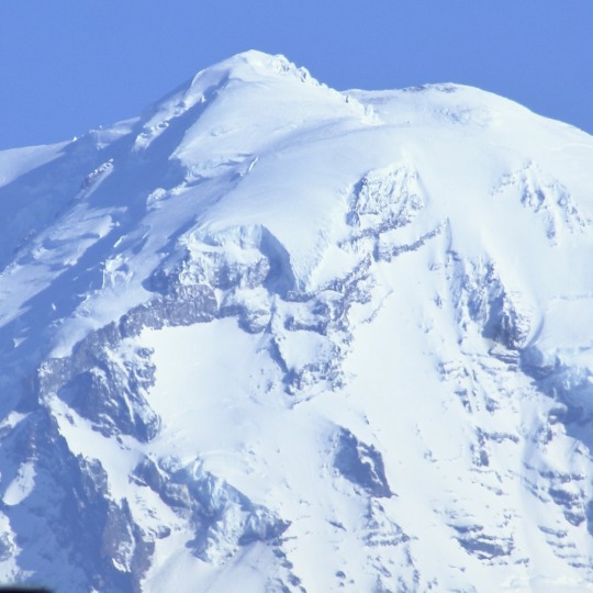
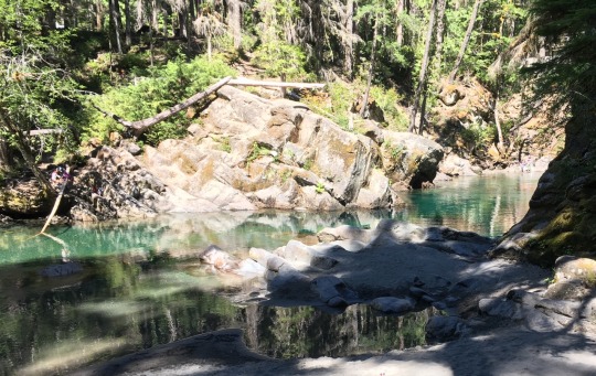
Mt. Tahoma, Mt. Ranier National Park, WA
#mt tahoma#mt rainier#mt ranier national park#pnw#pacific northwest#sony#sony alpha#sony a7ii#national park#washington
52 notes
·
View notes
Text

A sightseeing party poses in Washington State's park, known for its famous glacier capped peak.
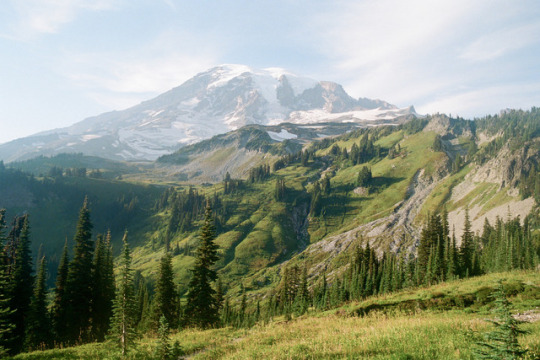
Mt. Ranier National Park
1908
#vintage camping#campfire light#history#road trips#washington#mt ranier national park#travel#exploring
105 notes
·
View notes
Note
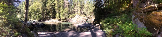
Mt. Ranier National Park, Washington State, USA

22 notes
·
View notes
Photo

Cougar Rock Campground. Mt. Ranier National Park
#mt ranier national park#national park#cougar rock campground#tent#picnic table#campgrounds#camping#camp#campsite#camplife#campout#outdoors#nature#wilderness#discover#adventure#explore
47 notes
·
View notes
Text
The “Elk Head” Mount Rainier, Washington
#mount ranier#mount rainier national park#mt rainier#elk head geolocical land mark#nature#washington#washington state#nature photography#photographers on tumblr#my photography
12 notes
·
View notes
Photo

Mt. Rainier national park
#washington#rainier#mt rainier#mt rainier national park#mt rainier nat'l park#mount ranier#mount rainier washington#mountain#montana#montaña#rainyer#more rainy#pacific north wear#pacific north west#pnw#snowy#west coast#mine#ohmandsuch
9 notes
·
View notes
Photo

Ball Of Fire | Summer Kozisek
Do not remove caption.
5 notes
·
View notes
Photo

#liam mcmillan#mt. ranier#yellowstone#film#35mm#portra#landscape photography#photography#nature#national parks
6 notes
·
View notes
Text
Wandering Hops: Epicenters and Fears

Fear makes things bigger in your mind than they are. This is especially true in my case taking that I have an anxiety condition.
For me, there is very little chill, and every issue, even a perceived issue can become a massive crisis in my head in an instant. This is one of the reasons I hike. Conquering miles and rough terrain, helps turn down the volume on all the static surging around and empowers me in my day to day.
At least, that’s how it normally goes…
Loowit Falls, at first, absolutely terrified me. As said in previous blogs, research is the key to a good hike. Before I set out on a trail, I check reports, check what the forest service (State or National depending) has to say. I read reviews on All Trails… and consult guidebooks if I have them.
Knowledge can make the difference between a great hike, and an utter disaster, so it helps to do your homework beforehand.
Cliches seem to be multiplying today, so let’s move on, shall we?
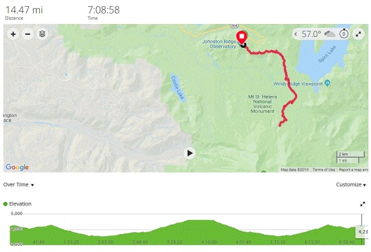
Selecting this hike, I knew it to be a challenge. It’s rated as hard, clocks in at a whopping 14 miles, and is a there-and-back-again hike. Any time spent going downhill in the beginning, means uphill at the end, and vice versa. As you can see from the altitude graph, this was going to make the end especially tough, but as I was reading, it wasn’t the physical challenge stressing me out, but the trail reports warning me of ledges with severe drops, gravelly sandy trails, and grueling up-hills that did.
Still, I’d been feeling strong the last month, making miles, and conquering hikes. Long hikes are my thing (more to come on that later) so a 14 miler seemed a logical next step.
With my chest tingling with excitement and a touch of fear, I told my team… “I’m gonna do it.” Or as Maya would say… YEET.
So now it was time for the research to really begin. I began looking at the topo maps, and followed the trail on google earth. I made my plans, talked to my husband, and began to get the logistics worked out.
Saturday, 0430, I was up and getting ready for my biggest hike to date, and all the while I was doing final gear checks, looking at maps, all that fun stuff, my nervousness beginning to build.
Then the husband woke up, around 630 as he often does before a hike, just to spend some time with me and said, in fearful tones.
“Bun, I’m worried about this one.”
I just smiled and said. “Me too, but I have fallbacks in place, and if it’s something I don’t think I can do, I’ll turn around and reassess.”
Then, he rose, hugged me, and began pricing life insurance policies.
I shit you not… this happened. I’m about to leave on a massive, monster hike, INreach SOS beacon charged, maps printed out, checklist double checked, and I’m looking forward to a nice encouraging talk with my husband, and he leaves to check on life insurance policies.
It’s moments like this that keep a marriage together, I tell you.
Full of confidence, I set out on highway 504 towards Mt. St Helens, the Spirit Lake Highway, only to run into a very unusual type of traffic in Toutle Washington.
Come to find out, there was a bike rally scheduled for the day of my hike, and there were hundreds of them on the side of the road, making their way to Johnston Ridge, the very same place I was going.
Now, I can almost hear you reading this, and shrugging, no big deal right? Well for most people that would be true, but for me, well… driving is something that makes me feel anxious, my mind likes to mess with me, and so for many years I didn’t. It’s only been recently after a lot of work and dedication that I’ve felt safe getting back behind the wheel again and now I had to deal with bikers everywhere, some of whom were so bold as to occupy the car lane, and refuse to yield.
On top of this, the weather turned foggy as I entered what is colloquially known as Big Foot Country, so as the long and windy road took me towards the parking lot, I was feeling more, and more stressed.
The day was beginning to feel cursed, my confidence was getting shakier by the moment, and I hadn’t even set out upon the trail yet.
Finally arriving at Johnston Ridge, the trail head, almost 4000 feet in elevation, the fog was even thicker. I couldn’t see more than 10 feet in front of me at any given time. Still, that was enough to sight the trail, and there were others there, getting ready for their own adventures. It was a motley mix of hikers, tourists and those waiting for the bikers to arrive as they picked their way up the road, but hey, at least there were porta-potties.
After taking a few centering breaths, and strapping on my gear, I set off, hiking towards Boundary Trail, which would eventually take me to Loowit Falls.
This entire section of Mt. St Helens is filled with history, making this trail an even bigger draw for me than others. Boundary Trail #1, was founded way back in the first decade of the US Forest Service. In 1911, Park Rangers rode horses from ridge to ridge, patrolling what was then the border of two national parks, Ranier and Columbia.
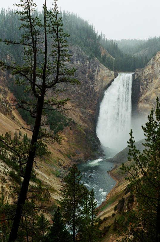
Loowit Falls on the other hand, is of the newer type of history. After months of erupting back in 1980, one morning a 5.1 earthquake struck the already battered region, and an entire wall of Mt. St. Helen’s crater collapsed, and turned into a hellacious landslide, ultimately opping a peak before crashing into the valley below, inundating Spirit Lake.
Loowit Falls was one of the many new features that arose out of the cataclysm shaping the region, up on the mountain itself, directly in the path of the former landslide.
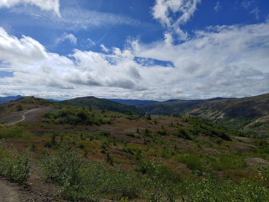
First though, I had to get there, and the hike starts off easily enough. There’s an observation loop that lets out to the Boundary Trail, that’s made more for tourists than hikers, so the first little bit is paved. Soon though, it gives way to gravelly dirt before angling down zig zagging and switchbacking, but I’ve seen all that before. Been there done that.
And there’s another cliche…
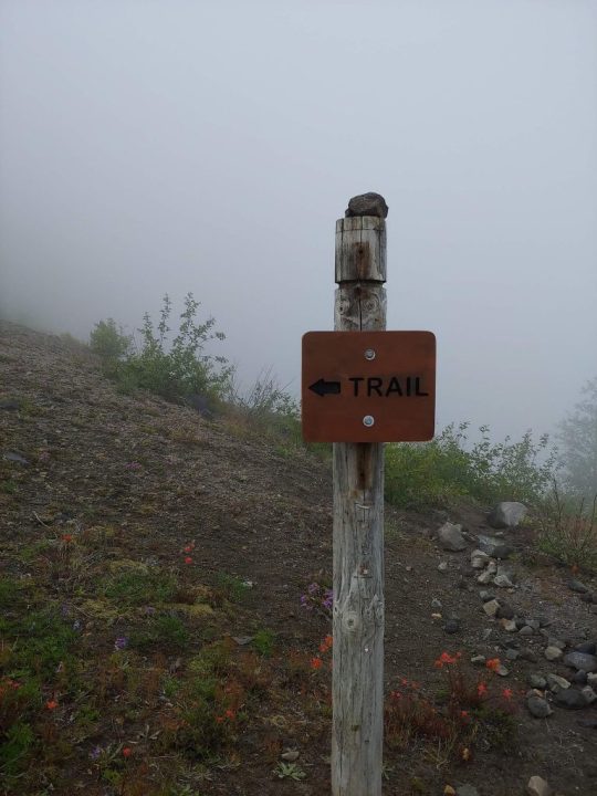
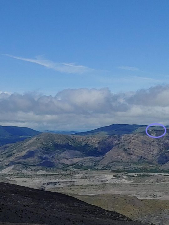
After about a mile and a half in, still wondering if I should really attempt to go for the falls, socked in by fog I came across a sign showing the trails in the area along with this picture…
Nervously, I set out from there, heading towards my decision point. I could have gone left, or right. Left had an easier hike, that went up to a peak, ending at around 10 miles covered, with less elevation gain, but to my right, shrouded in fog and mystery, was the hike I came to conquer.
This was the real moment of truth. All I had was my research that said it could be challenging. Some reported the height could be intimidating, others said it was merely tough.
What should I do?
Taking a (figurative) leap of faith, I decided to for it, comforting myself with the idea that it was ok to turn back if things got to intense, and began to descend down the trail, and the mountain, making decent time. The pillowy shroud of fog continued to lay across the trail granting me no wider vista than 5 or 10 feet, but the path was wide, and while I did get closer to edges I still had plenty of room.
Eventually things leveled out and I could tell I was in a valley as the fog slowly began to lift, and I’m thinking is that it? Really?
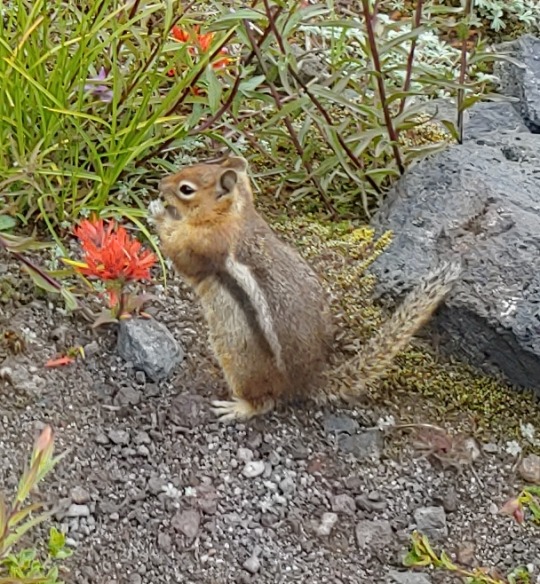
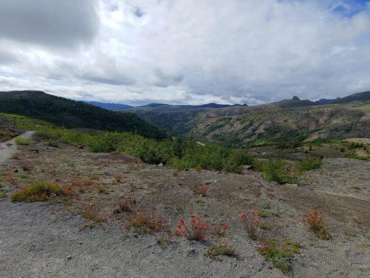
From my perspective there had been nothing to be truly afraid of. The descent wasn’t especially challenging and I had felt safe the entire time. Unlike the husband searching for life insurance, this buoyed my confidence, even though I had eleven miles still to go. With a bounce (hop?) in my step I set out, the fog continuing to lift, revealing more of the stark landscape around me. Black and red lava rocks dotted landscapes that were in some places sandy, other places akin to moonscape, sparkling with volcanic glass and in others, covered with thick shrub like trees, or coated in wildflowers of amazing colors. Chipmunks ran to and fro, eating flowers and wondering if I was going to feed them, while birds flew overhead.
Then it happened. Suddenly the clouds broke and there was a literal mountain in front of me, emerging out of the fog like some giant from the dusty tomes of mythologies. Mt. St. Helens lay before me in all its majestic glory, and off in the distance, a light glinted off a fast moving waterfall surrounded by volcanic sand.
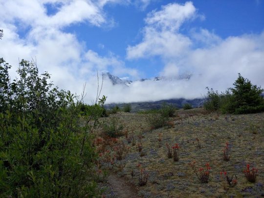
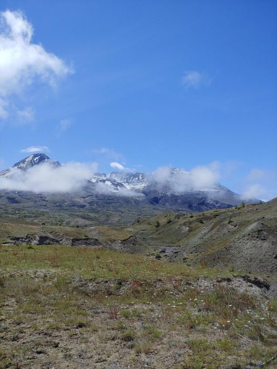
That was my half way point, where I would turn around and come back, Loowit Falls.
I stood there for a moment and took it all in. The vista before me left me awestruck by the power of nature. Then, taking a deep breath, I dug in my trekking poles and began to hike.
And hike….
Then hike some more…
As I went traffic fell away to a few familiar faces, I’d pass them, then they’d pass me as we took alternating breaks, until finally around 2pm, I rounded a switchback, and heard for the first time the roar of a waterfall.

There it was, right in front of me, the moment I had been waiting for. Loowit Falls, in all its splendor, flowed relentless down the mountain as the wind howled off the glaciers above, chilling the air to what felt like the mid to upper 40’s.
Buttoning down my outer layer, I made my way to a flat spot, laid my pack out and had lunch, reveling in my victory only for my open pack to flop over and spill out on the ground, voiding its contents. I went from resting to scrambling as I dove for my glasses and meds, hoping they wouldn’t fall off the edge.
In some ways, it reminded me of the day so far, there was a sensation of “emotional breathing” to the experience, stress followed by periods of ease, akin to the contraction and relaxation of breathing. Up and down, in and out, oh shit to okay…
And this was the halfway point, soon I’d have to go back the way I came, picking my way back up the mountain I had descended to get back to the trailhead. The only difference being, was that now I knew the trail, I knew what to expect, so I hoisted my pack, tightened down my straps, took some water, and got back on the trail.
My speed increased, as the air warmed and I left the slopes of St. Helens, making good time across the dramatically stark volcanic plains. Gradually, I began to feel more accomplished than I had in a while and, by the time I had hit ten miles I was riding high. With four miles left to go I charged forward, eager for the challenge.
Then I started to climb. All of the descent from the morning, had to be repeated, this time going up. This is where it got grueling, as if the trail was attempting to punish me for every step I made down upon it just a few hours before, but there was nothing else to do but push through it, keep pace, and enjoy the view as I ascended, granting me new perspective now that the fog was gone.
There were places where it was quite steep, and the drops quite far, the morning’s fog had hid all that from me, but there was room, there was space, it was something to respect, but it wasn’t anything to fear.
All of that worry, all of that concern, and if I had let it stop me, I wouldn’t have been there.
Humbled by that revelation, sore from the elevation I was having to make, and humbled by a day full of experiences, I pushed myself up the trail. Soon there was the last arcing climb, until I set my feet on the pavement of the observation trail yet again, and just beyond was the parking lot.
Setting my gear in the well of the passenger seat, I popped an electrolyte tab into my water and watched it fizz as I nibbled a Clif bar, feeling like the master of my own little universe, resting from the exertion of the day. Once I had some time to recharge, I put the key in the ignition, put the car into drive, and had a major anxiety attack.
The problem with anxiety attacks it that you know, rationally, everything is fine. The problem is your brain isn’t listening to reason. I worked through my coping skills, and tried to get myself centered, but nothing was working. I was exhausted from the hike, and the worries of the day, and it was all crashing in on me at once, amassing as a parade of my biggest fears, and inner demons within my mind.
I made it about three miles before I had to pull over. I stopped in at the Coldwater boat dock, the location of last week's hike, and took a few more deep breaths, walked around the car, and tried to get my mind right. Finally I messaged my husband letting him know what was going on.
Messages travel slower by satellite than text, and so I had some time to sit. I looked out on the parking lot, at the strange bathrooms that looked like forgotten temples, and it reminded me that I had hiked twelve miles last week, and today, I had hiked fourteen…
That caused my brain to stop and pause for a moment, like rays of sunshine penetrating the gloom.
I had excelled through challenges, walked along ridges, and managed my water. I was capable, I was competent, and I was ok.
In the face of this revelation, the anxiety began to let go, and a lightbulb went off in my head. I had a weapon now against it, a reminder, that I was stronger than I thought, and as the messages came back from my husband and other supportive folks, the anxiety withered away.
In spite of all of the difficulties of the day, I had made it, and now, all I had to do was drive home. Turning the car back on, and setting into drive, I carefully made my way out of the parking lot, already thinking of next week's adventure.
#hiking#adventure#mtsthelens#wanderinghops#studioprey#rebeccamickley#pacificnorthwest#trailreport#amblogging#blog#pnw#anxiety#fear
21 notes
·
View notes
Text
July 24 — Mt. Ranier National Park
Ohanapecosh Campground


2 notes
·
View notes
Photo

haven’t had a chance to pull photos off my camera yet, but here’s a cute moment from just outside mt rainier national park 🍂🏔🌲✨ . . . . . #nyc #newyork #newyorkphotographer #newyorkcity #nature #seattle #olympicnationalpark #nationalpark #cute #happy #olympia #beach #ranier #mtranier #trees #ocean #travel #wanderlust #pnw #photography #gay #instagay #gayboy #pride #instagood #vsco #pacificnorthwest #love #liveauthentic #fall (at Mount Rainier National Park) https://www.instagram.com/p/Bo786Kog4HX/?utm_source=ig_tumblr_share&igshid=c777y5o2jn2s
#nyc#newyork#newyorkphotographer#newyorkcity#nature#seattle#olympicnationalpark#nationalpark#cute#happy#olympia#beach#ranier#mtranier#trees#ocean#travel#wanderlust#pnw#photography#gay#instagay#gayboy#pride#instagood#vsco#pacificnorthwest#love#liveauthentic#fall
6 notes
·
View notes
Photo

Absolutely loved visiting Mt. Ranier National Park today. I can't wait to go back! My @bornprimitive athleisure top keeping me warm! #nofilter #mountrainier #washingtonstate #crossfitgirls #girlswholift #outdoors (at Mount Rainier National Park)
11 notes
·
View notes
Text
We Go To The Mountains! ⛰ ❄ 🌨🏠
We are going to put down a reservation at the Mt Ranier National Park for Xmas weekend! 🥰 Hopefully the cabin we want won't be taken by the time we can get the reservation. If not, it's okay, we will find another. They all come with a hot tub. I can see us both nekked and 🥂 drinking. Rofl 🤣
We are going to get some acid and hike. He was talking about skiing. 🤣 I'm like:
Have fun, I'll be inside getting drunk! 😊🍺
I don't do any kind of sports. Was forced into it every lame ass summer. I'm too clumsy and nervous. So if he wants to skii, I'll just watch drunk (and probably high) as fuck bundled up in like 5 layers of clothing. Erik doesn't want me to be a stick in the mud. 🤣 I just think he gets a kick out of me falling on my ass like last winter on the hard as fuck snow.
Would be nice if we go to a resort to check out some eye candy.
That's a vacation for me! Yes I have a boyfriend but I'm also human. My bf and I are secure in our relationship too. That's what I really love. Things don't get weird if I tell him I think someone is hot because at the end of the day, I'm with him. Besides I already have 2 men in my life. Its difficult enough I had one who is "dead" and one alive and they are very alike. My hands are full.
Maybe we should do this for new years...
Will have to see the availability when I get paid. This is very exciting! 🤩 I'm lucky to be able to take several vacations a year. We just got back from 2 weeks in Florida. We go back in April this time with my dad and that side of fam coming along.
😘💕 Stay safe, yall!
#channelingerik#channeling#twin flames#twinflame#mediums#twinflames#psychic#my life#mediumship#vacation#vacation 2021#winter vacation
0 notes
Text
Planning My West Coast Dream Trip
SO this is the year I FINALLY make it to the West Coast. I’m an Ohio gal - born & raised - and the farthest west I’ve ever been is Idaho & Las Vegas, so this upcoming trip is going to be life-changing for multiple reasons.
As my blog name notes, I’m a lover of all things Haunted, Lighthouse, & History-related, so this trip will incorporate as much of those things as humanly possible!
Here is my current plan.
Fly into Seattle early- around 9:00 A.M. Spend a good portion of my day there. Then start heading south down I-5 towards Portland. I’d LOVE to detour over to Mt. Hood, Mt. Ranier, Mt. St. Helens & Multnomah Falls, but I’m so worried at this point whether I will have the time to designate to everything I want to see! I’m planning on this being a 9-day trip, so here’s a general itinerary. Seattle and Portland will more than likely be day trips each, as I really want to spend the majority of my time in nature or on the coast.
I’d like to see the Space Needle & Pike Place Market in Seattle, but then head to Mt. Hood/Mt. Ranier/Mt. St. Helens/Multnomah Falls or any feasible combination of that group. I then would spend a day in Portland seeing Powell’s City of Books, VooDoo Donuts, The International Rose Test Garden & take a Shanghai Tunnels/Portland Underground Tour!
I then want to drive South through Salem and Eugene and then make my way down to Crater Lake! I then would like to stop over into Ashland OR to see the Allen Elizabethan Theatre before dipping into California to see the northern-most Coastal Redwoods National Park. After that, I plan to stick to the coast and head all the way up Oregon: From Brookings to Astoria, (stopping at all the lighthouses along the way) which, according to Google Maps, is roughly a 7-1/2 hour drive straight through (& 11 lighthouse)!
The ONLY thing I have booked so far is a one-night stay at The Heceta Head Lighthouse Bed and Breakfast Between Florence & Yachats (The Central-most area of the state) on the Tuesday of my trip. It is my FAVORITE lighthouse and the main reason I’m making this trip, so the fact that I solidified one night there (the room rates were upwards of $300/night with taxes and fees... YIKES!) but I will have the only room in the B&B with a direct view of the lighthouse! Makes me teary-eyed just thinking about it. <3
What I need some help with at this point is honest opinions. Anything I shouldn’t miss? Anything that is touristy and easy to skip? I REALLY want to spend some time in Florence, and would love to make a few stops in Tillamook, Newport, Ecola Beach, Cannon Beach & Astoria, so is this trip feasible?! Am I going to be running myself ragged in order to see everything on my list?
If you happen across this, and can give me some suggestions, I’d be endlessly appreciative.
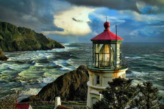
Heceta Head Lighthouse Photo Credit
#hecetaheadlighthouse#OregonCoast#TravelPlanning#TravelAdventures#WestwardHo#OregonTravel#MountStHelens#MountRanier#MultnomahFalls#Portland#Seattle#InternationalRoseTestGarden#VooDooDonuts#PowellsCityOfBooks#Lighthouses#CoastalVacation#WritingRetreat#AmWriting#AdventureAwaits#FlorenceOR#OldTowneFlorence#Astoria#Brookings#Tillamook#Cascades#HikingAdventures#SeaLionCaves
0 notes
Photo

BAMBI MEETS GIRLZILLA
MT. RANIER NATIONAL PARK, WASHINGTON STATE. RED DEER
Ranier National Park is full of wild life which can be seen near the hotels and along the highways. Here a young, friendly deer greets a tourist.
136 notes
·
View notes
Last Seen Blogs

chinasamsunggalaxys8-blog
samsung s8 price in china

medicasino-sims
oh god Affie simblr time

horrotime
your favourite local horror fan

fosters-hoe
bloo

whothefuckisjanefonda
Fonda Me, Fonda You