#Global Positioning System
Explore tagged Tumblr posts
Visit Tumblr Blog
Explore Tumblr blogs with no restrictions, modern design and the best experience.
Last Seen Tumblr Blogs


Fun Fact
69% of Tumblr users are millennials.
Text
#RelocationTime
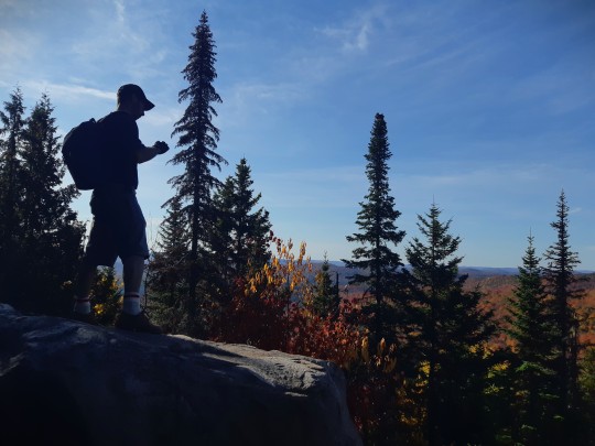
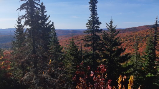
Mountainous Parts of the Northern Hemisphere.
#Relocation Time#GPS#Global Positioning System#Fall Season#Autumn#Color Splash#Nature Photography#Landscapes#Mountains View#Hiking Trails#Altitude Life#ECCC#Environment and Climate Change Canada#NCC#Nature Conservancy of Canada#Mountainous Parts of the Northern Hemisphere#Canada#The RavenKeeper
522 notes
·
View notes
Text
Fundamental physics—let alone quantum physics—might sound complicated to many, but it can actually be applied to solve everyday problems. Imagine navigating to an unfamiliar place. Most people would suggest using GPS, but what if you were stuck in an underground tunnel where radio signals from satellites were not able to penetrate? That's where quantum sensing tools come in. USC Viterbi Information Sciences Institute researchers Jonathan Habif and Justin Brown, both from ISI's new Laboratory for Quantum-Limited Information, are working at making sensing instruments like atomic accelerometers smaller and more accurate so they can be used to navigate when GPS is down.
Continue Reading.
115 notes
·
View notes
Text
Female Inventions (Day 3) Gladys West (Oct 27, 1930 - Present)

Born in Sutherland Virginia, inducted into the United States Air Force Hall of Fame, and played a vital role in creating the modern GPS system. Read more about Gladys West here and the creation of the GPS system here!
2 notes
·
View notes
Text
What is GPS ?
GPS stands for Global Positioning System. It is a satellite-based navigation system that allows users to determine their precise location and track their movement on the Earth's surface. The system provides information on latitude, longitude, altitude, and the current time at the user's location.
The GPS system consists of a network of satellites in orbit around the Earth. These satellites transmit signals to GPS receivers on the ground or in devices like smartphones, cars, and other navigation systems. The GPS receiver uses the signals from multiple satellites to calculate the user's precise location through a process called trilateration.
The accurate positioning information provided by GPS has a wide range of applications, including navigation for vehicles, aircraft, and ships, tracking and mapping, surveying, and various location-based services such as geotagging in photos and finding nearby points of interest. GPS has become an essential tool in both civilian and military applications, significantly impacting various aspects of daily life.
Link : What is GPS

1 note
·
View note
Text
Truck Platooning Market Analysis by Trends, Size, Share, Growth Opportunities, and Emerging Technologies
It is common to hear in the news that a truck met with an accident, and the truck driver got badly injured or died. According to the data of National Safety Council, 5700 large trucks were involved in a fatal crash in 2021, which was 18% more than the preceding year.
So, the challenges involved in the day-to-day job of a truck driver on the job is a big reason for the shortage of labor in the industry. Trucking also involves long, hours spent squeezed into a cab. There are strict deadlines to be met, and this job requires the utmost attention. It is important that quality of life of the trucker should be improved, and truck platooning can surely help you with the way forward.
It is a Semi-Autonomous Approach
If you talk about platooning, it does not replace the existing trucks with a driverless solution, so, it is clear that it is not about full autonomy. Yes, you can always think of platooning as a strategy, which is made possible with the help of the developments in the field of connected driving.
Platooning is when many trucks, in the guidance of a lead truck can follow each other closely. These can accelerate, break, and take a turn while semi-automatic features in the lead truck reduces the probability of human error. Although, the lead truck is controlling the fleet, the following trucks will also have drivers so that they can complete their scheduled deliveries, by breaking the chain.
Fuel Costs are Reduced Considerably
It is not just about enhanced safety but, platooning can do good for the truck drivers and the trucking companies as well. By letting trucks to drive in close proximity, there is a reduction of the aerodynamic drag and the space taken by the trucks on the road, reducing the costs of fuel.
Room For Relaxation on the Roads
This might spring a surprise to many that how it is possible to have a room for relaxation, and that too while driving such a heavy vehicle, like truck. But, believe me it is true.
Platooning also enhances the experience of trucking. Drivers in the trucks, following the lead feel comfortable because of the presence of technology. It allows them to take their foot of the pedal and relax.
The Concept of Tele-Trucking
With the improvement in technology, platooning could transform the trucking industry. Drivers can monitor and operate their trucks remotely. And many drivers could work from the same room, decreasing the level of loneliness.
Get More Insights: Truck Platooning Market Analysis and Demand Forecast Report
There is often a threat to people with technology, that it could replace people but it is too hard to be true. With the implementation of truck platooning, it will not replace people, but it would take out the dullness from their jobs and make it more enjoyable.
Final Sum Up
It is quite clear that due to the need for safer road transport by the people, and to make the life of the truckers a bit easier, the demand for truck platooning will continue to advance in the future.
#Global Positioning System#Human–Machine Interface#Forward Collision Warning#Autonomous Emergency Braking
0 notes
Text
What is GPS and How does it work?
GPS, or Global Positioning System, is a satellite-based navigation system used worldwide. It allows us to determine our exact location, speed, and time with exceptional precision. By receiving signals from multiple satellites, GPS receivers triangulate our position, making it an essential technology for navigation and location-based services. To learn more please visit here: https://www.opennaukri.com/what-is-gps-and-how-does-it-work/
0 notes
Text
fit and his ability to spot pac from literally miles away, or somehow, through fucking walls ???
#qsmp#fitmc#pactw#fitpac#qsmp clips#fit's vod happened to corrupt or something for specifically that last bit making it impossible to clip >:(#anyways fit got a gpps: global pac positioning system#or as a chatter put it: his gaydar.
1K notes
·
View notes
Text
Yeah, I get the question (and sometimes the brand names are jarring!) but the specific alternatives here sounded weird for me. If this is supposed to be set in the 2020s I'd say "she put the address into her phone map" (perhaps "phone map app", or just "map app" because apps are supposed to be on phones anyway*) or maybe something like "asked her phone for directions" - which would be conveniently ambiguous between Google, Yandex, Waze, and a bunch of other more marginal options. (I do have to admit that "she set her Google Maps to give directions" would sound a bit like product placement unless it's deliberately intended to be a detailed look. I'd be fine with something like "she put the address into Google Maps", though.)
When I read "she put the address in her GPS" I'm imagining a standalone GPS device that was 1) advanced enough to put an address into (I believe there used to be specific CDs with the databases...) and 2) not yet just part of the smartphone. So, yes, 00s to mid-10s (and it was probably a Garmin). (Side-note: technically, GPS is supposed to be another brand rather than a generic term (competing with e.g. Glonass), and modern "GPS" devices actually use several of those systems at once! But the genericization on that one had bolted long ago and if you say "GPS" you'd be understood better than if you tried to look for actual generic terms.)
More generically (...somewhat following on to the GPS point just above), sometimes you have a problem where the brand name is so much more familiar that using the generic name for whatever service it is would just look weird! If it would even be intelligible at all.
Suppose that you don't want to say Twitter in your 2024 book because you don't think your 2026 or 2036 readers would know what Twitter is. (I'm using Twitter as an example because it's one case where it would actually be plausible that in a few years there'd be people unfamiliar with the brand name, but conveniently it also makes the following point easier to state.) What would you use? "Microblog" (or, worse, "microblogging service") would sound ridiculous. "Social media" is too generic (unless you want your readers to assume it's Facebook). "Mastodon" is even more specific (and might not necessarily be a recognizable thing in 2030 either). "X" could easily be just as unintelligible in the future (especially if it's later renamed to something else again) and in the meantime it makes you look like a Musk fanboy. So pretty much you'd need to either make up a brand (and hope it's not the actual name of something unrelated) or give in and say Twitter.
OTOH if your characters are using Twitter (or Google - Maps or otherwise - or Siri, or Facebook, or Discord, or indeed Tumblr... or, in one unfortunate example that comes to mind, MySpace) in, say, 2231 (or some other blatantly-far-future date), then either you're deliberately making a point about the persistence of existing brands, or you should probably change that to something less time-specific, and/or something made up for the story. (I'll give "GPS" a pass, unless it's set on another planet. Even then it's probably not that bad of a choice.)
And as a final side-note - I do love it when a story set in a particular time period uses authentic technology and recognizable brand names for that time period.
It's great if your characters in 2006 are posting on MySpace and putting addresses in MapQuest! (Though they probably wouldn't be doing it on their phones...) If anything it's more jarring if the story uses a brand name (or other technology) that didn't actually exist in the relevant time period (no, Rowling, there were no PlayStations in 1994, or not in the UK anyway).
(BTW, I voted for the third option in the poll, because it was a convenient "it depends" option that didn't really hinge on whether Google and GPS were in fact the same thing. Which they aren't, but not for the reason that the OP was trying to imply.)
*) unless you're Discord and don't like the word "bot" for some reason
Reading a book now that in the same few paragraphs mentioned Siri, google maps, and another app all at once, and I was kind of overwhelmed by how specific that is—to Apple, to right now, etc. I got bogged down in wondering if that section would be legible in 15 years, like if Siri goes away or is renamed or no one uses Apple phones.
What are your thoughts on books including specific app or brand names, which might end up dating it (like all books with “twitter” in them are now Pre 2024 books)?
Aka, would you prefer to write/read “she set her google maps to give directions” or “she put the address in her gps.”
#GPS#global positioning system#Google Maps#Yandex Maps#Guru Maps#my dad often uses that last one because it works even with inconsistent internet access#I'm sure there's a ton of other navigation apps that I just don't happen to know much about#Twitter#microblog#microblogging#as far as I'm concerned as long as it's on twitter.com it's still Twitter#the MySpace one was Times Like This strip 35 if you were wondering#if you don't get the Discord reference it's because they just changed their “bot” label on webhook posts to “app” and I don't understand wh#found via foone
337 notes
·
View notes
Text


A comedy in 2 acts
#as#leftists continue to incoherently support a position identical to far right white nationalists’ but only towards jews#borders are insane EXCEPT if it’s jews crossing them then it’s colonialism sorry just fucking die I guess lol#there’s some post going around tumblr too that’s like remember we only have this global system of immigration restriction because countries#were trying to keep out jewish refugees and send them back to die but. that’s antizionism! that’s the position you claim to support!#it’s your position that the british firing on jewish refugees and detaining them in camps in Cyprus was based and anti colonial actually!#you can’t be an antizionist and also say global immigration restriction is immoral you only don’t realize this because you are that stupid#if all a far right movement has to do to get you to oppose immigration is call it colonialism how do you actually meaningfully disagree
8 notes
·
View notes
Text
SIRIUSXM SATELLITE RADIO GPS
#gps#SiriusXM#siriusxm#SIRIUSXM#GPS#GLOBAL POSITIONING SATELLITE SYSTEM#SATELLITE RADIO#SIRIUSXM SATELLITE RADIO#🛰️
20 notes
·
View notes
Text
concept that i started thinking of earlier today and am now irrevocably in love with: Cassandra Maps
in which. gorgug helps kristen launch a cassandra satellite. because of cass's space theme. and then cass gps. and cass maps. because she's there for people who are lost. you see my vision
#anyways was going through my drafts and read the first sentence and was like oh yeah cass cain and maps mizoguchi yeah people have been sayi#nope.#cassandra as in fantasy high and maps as in global positioning system
3 notes
·
View notes
Text
Satellites: Their Orbits, Tracking Systems, and Essential Uses
Satellites: Their Positions, Tracking, and Importance
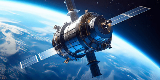
Satellites have become an essential part of modern life, orbiting Earth and providing us with services ranging from communication and navigation to weather forecasting and space exploration. As of 2024, thousands of active satellites are circling our planet, each performing a specific role to enhance the quality of life on Earth. This article delves into the positioning of satellites, how they are tracked, what they track, and the significance of their roles.
Types of Satellite Orbits and Their Positions
Satellites are positioned in various orbits depending on their intended functions. These orbits determine how close the satellite is to Earth, how fast it moves, and what areas it covers.
Low Earth Orbit (LEO): Altitude: 180 km to 2,000 km Satellites in LEO include most Earth observation satellites, the International Space Station (ISS), and some communication satellites. These satellites are closer to the Earth, enabling them to capture high-resolution images. Functions: Used for imaging, remote sensing, and some communication purposes. Examples: ISS, Earth observation satellites like Landsat.
Medium Earth Orbit (MEO): Altitude: 2,000 km to 35,786 km Satellites in MEO are mainly used for navigation. This orbit offers a good balance between coverage and latency. Functions: GPS satellites and other global navigation systems. Examples: GPS, GLONASS, and Galileo satellites.
Geostationary Orbit (GEO): Altitude: 35,786 km above the equator Satellites in GEO move at the same rotational speed as Earth, meaning they stay fixed over one location on Earth. These are mostly communication and weather satellites. Functions: Used for television broadcasts, weather monitoring, and some types of communication. Examples: Weather satellites (GOES series), telecommunication satellites.
Highly Elliptical Orbit (HEO): Orbit shape: An elongated orbit with one point closer to Earth (perigee) and another point much farther away (apogee). Functions: Ideal for regions at high latitudes, providing prolonged coverage over areas like Russia and parts of Canada. Examples: Molniya satellites for communication in Russia.
How Satellites Are Tracked
The sheer number of satellites in space, combined with space debris, means tracking them is essential to avoid collisions and ensure their functionality. Ground stations and dedicated space agencies continuously monitor satellites. Several methods are used to track satellites:
Radar and Ground-Based Systems: Ground stations use radar to track satellites in LEO. These systems bounce radio waves off the satellite and measure the time it takes for the signal to return. By doing this repeatedly, they can track a satellite's location and speed.
Global Positioning System (GPS): Satellites in higher orbits like MEO or GEO are tracked using onboard GPS receivers. GPS helps calculate the satellite’s position and relay that data back to Earth.
Optical Tracking: Telescopes and cameras are used to visually observe satellites in higher orbits. This method is particularly useful for tracking objects that do not emit radio signals or need to be monitored for their physical characteristics.
Space Surveillance Networks: Agencies such as the U.S. Space Surveillance Network (SSN) and similar organizations in other countries continuously monitor satellites and space debris. They catalog objects and issue alerts for potential collisions.
What Satellites Track
Satellites are equipped with various sensors, cameras, and instruments to track a wide array of data on Earth, in space, and beyond:
Weather and Climate Data: Satellites such as NOAA’s GOES series monitor weather patterns, hurricanes, and long-term climate changes. They provide crucial data for meteorological services.
Earth Observation: Satellites like Landsat capture high-resolution images of Earth's surface. These images are used for mapping, agricultural planning, disaster response, and environmental monitoring.
Navigation Signals: GPS and other GNSS (Global Navigation Satellite Systems) satellites send signals that are used for navigation by smartphones, vehicles, ships, and airplanes worldwide.
Communication: Satellites facilitate global communication by relaying TV, radio, and internet signals across vast distances.
Space Exploration: Space telescopes like the Hubble Space Telescope track distant galaxies, nebulae, and black holes, helping scientists study the universe.
Military Surveillance: Many satellites are designed for defense purposes, tracking missile launches, military movements, or spying on potential threats.
Number of Satellites in Space
As of 2024, there are approximately 8,000 operational satellites orbiting Earth. The exact number fluctuates as new satellites are launched and old ones are decommissioned. Additionally, space agencies and private companies like SpaceX continue to launch large satellite constellations, such as Starlink, which alone has over 5,000 satellites in orbit for global internet coverage.
The Usefulness of Satellites
Satellites have become indispensable in modern life, serving a wide variety of purposes that impact everyday activities and critical global functions:
Key Functions of Satellites:
Communication: Satellites enable long-distance communication by transmitting data, television, and internet services. Without them, global broadcasting and real-time communication in remote areas would be impossible.
Navigation: Systems like GPS help millions of people navigate in real-time. They are also vital for the functioning of aviation, maritime travel, and even agricultural practices.
Earth Observation: Satellites provide high-resolution imagery of Earth, helping with disaster management, urban planning, agriculture, and environmental monitoring. For instance, they can track deforestation or observe glaciers' melting rates.
Weather Forecasting: Weather satellites provide the data needed for accurate predictions, storm tracking, and climate monitoring. This information is critical for preparing for natural disasters like hurricanes or floods.
Scientific Research and Exploration: Space telescopes and interplanetary satellites gather data on space phenomena, expanding our understanding of the universe. Satellites also conduct scientific experiments in the microgravity of space.
Defense and Security: Satellites are used for military surveillance, early-warning systems, and missile detection, playing a crucial role in national security.
Satellite Highlights in Brief:
Types of orbits: LEO, MEO, GEO, HEO, each serving different purposes.
Tracking methods: Radar, GPS, optical tracking, and space surveillance networks.
Data tracked by satellites: Weather, Earth observation, navigation signals, space exploration, and military surveillance.
Number of active satellites: Approximately 8,000.
Key roles: Communication, navigation, weather forecasting, Earth observation, scientific research, and defense.
In conclusion, satellites are essential tools for global communication, navigation, monitoring Earth's environment, and scientific discovery. As technology advances and the number of satellites continues to grow, their impact on our daily lives will only increase. Whether improving how we predict the weather, navigate through traffic, or explore the universe, satellites will continue to be a critical resource for humanity.
Go To How Satellites Work and What They Track
#satellite orbits#satellite tracking#satellite functions#low earth orbit#geostationary orbit#medium earth orbit#space technology#GPS satellites#communication satellites#weather satellites#Earth observation#satellite uses#satellite positions#how satellites work#space surveillance#satellite navigation#satellite networks#satellite importance#global navigation systems
7 notes
·
View notes
Text
Passion Seed

PassionSeed is not just a platform—it’s a movement. It’s where passion meets purpose, where creators are empowered to make a difference, and where audiences can engage meaningfully with content that inspires and uplifts. Whether you’re an artist, educator, entertainer, or innovator, PassionSeed invites you to join a community built on respect, creativity, and shared growth.
#PassionSeed#Authentic Content#Creative Community#Positive Platform#Purpose-Driven#Uplifting Media#Safe Space for Creators#Meaningful Engagement#Live Streaming#Content Creation#Creator Support#Viewer Interaction#Tips & Payouts#Bi-weekly Payout#Stripe Payments#Real-Time Engagement#Feedback Loop#Transparency#Fairness#Inclusivity#Empowerment#Integrity#Moderation System#Equal Opportunity#Community-First#Global Reach#Multi-language Support#Region-Specific Features#Cultural Diversity#Digital Empowerment
2 notes
·
View notes
Text
Oh man just when I thought I've seen it all here I come across a bunch of pro-isreal blogs calling the Irish juddenhassen and characterizing them as "drunk football hooligans cosplaying as Palestinian" ... Talk about having a shallow and deliberately dismissive understanding of a country's history. I can't possibly imagine the history or conflict that makes Palestine relatable to the Irish. Also the 'cosplaying' dig is hilarious because you definitely wouldn't respect them more if they were actually Palestinian!
#and like. i dont want to downplay antisemitism in amy country but like. wow super cool rascist charicature you conjured of the oafish#violent drunk stubborn low intelligence anamalistic Irish in response to them as a people sympathizing with another population that has#experinced occupation#like to be clear anti irish rascism is not a global killer or anything like the irish are largely considered white in the colonies and stuf#but like holy shit thats fucking ugly if how you respond to colonized people showing solidarity for each other is just instantly reverting#to every sterotype foisted on them to justify treating them as religiously primitive beligerants#mine#like im jsut posting i thought it was insane its not a big deal#anti irish attitude is not systemic anywhere outside of the Isles i was just like wow okay we are reaching into that bag out of rage at#palestinians being recognized as human#and the 'football hooligan' characterization is an especially disgusting way to react to like. federal leaders of the whole country having#position you dont like
7 notes
·
View notes
Text
Brazil’s Education System: Progress Persistent Gaps
Official data from Brazil’s Ministry of Education and the Brazilian Institute of Geography and Statistics (IBGE) reveal a mixed picture for the country’s education system in 2024. While the nation has achieved near-universal enrollment for children aged 6 to 14, with 99.5% attending school, the story changes for older students and adults. Only 56% of Brazilians aged 25 or older have finished high…

View On WordPress
#Analysis:#annual#Awards#Brazils#Celebration#conflict#controversial#Economy#Education#Exclusive#feature#Gaps#global#Interview#live#Local#monthly#negative#persistent#politics#positive#progress#protest#rural#scandal#Science#Sports#System#Technology#Update
0 notes
Text
Laugh, it's World Laughter Day!
World Laughter Day, celebrated annually on the first Sunday of May, is more than a mere occasion for lightheartedness; it is a deliberate and profound initiative rooted in the vision of Dr. Madan Kataria, the esteemed founder of the Laughter Yoga movement. Image found on Internet Established in 1998, this day serves as a global clarion call, urging humanity to recognise and embrace the…

View On WordPress
#African Folklore#apana#Celebration#Comedy#connection#cortisol#Dr. Madan Kataria#endorphines#Energy#First Sunday of May#Funny#Global Event#Greek comedies#Happiness#Hasya#Humor#immune system#joy#Laughter Circle#Laughter Exercises#Laughter Yoga#meditation#Mental Health#mindfulness#Mudita#positive psychology#positivity#Raffaello Palandri#Shakespeare#stress
0 notes