#aerial perspective
Photo


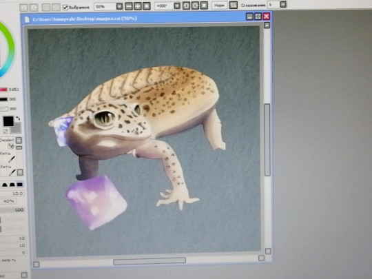
空気遠近法のヒント #ysdtips
勉強になる〜
64 notes
·
View notes
Photo


Joseph Lycett (1774-1825) born in England, transported to New South Wales 1814
1 Aborigines spearing fish, others diving for crayfish, a party seated beside a fire cooking Fish (1817) watercolour
2 Fishing by Torchlight (1819) watercolour
A abc.net.au For years, an album of remarkable Australian paintings languished in a second-hand book shop in London. It was the work of Joseph Lycett—a convicted English forger who was transported to New South Wales in the early nineteenth century.
The National Library of Australia stepped in and bought the book. It's now been given the highest priority in the National Archives.
On his arrival in Sydney in 1814, Joseph Lycett was seconded by Captain James Wallis in Newcastle to illustrate the new settlement with the hope of attracting migrants. Lycett also closely observed the Indigenous people.
The Lycett Album, consisting of 20 watercolours, observes in detail the cultural practices of the Awabakal people of the Newcastle region. It depicts activities, daily life and interactions that had not previously been recorded, and have since disappeared.
B Linda Groom nla.gov.au
One of the items of considerable significance in the National Library’s Pictures Collection is the bound volume commonly referred to as ‘the Lycett Album’. It contains twenty watercolours painted prior to 1828 by Joseph Lycett (c. 1775-1828).
Although a number of European artists of the early colonial period, such as Nicolas Martin-Petit and Richard Browne, made portraits of Aborigines, it is rare to find paintings that show the daily life of Aborigines. Among Lycett’s watercolours are the only known depictions from the period of Aborigines engaged in activities such as spearing eels and eating meat from beached whales.
Early colonial Australia did not attract many professional artists; most paintings prior to the 1820s were made by convicts or naval officers. Joseph Lycett was a convict, transported for forgery. During his time in Australia from 1814 to 1822, he was given freedom to work as a clerk and as an artist, except for one year of hard labour in the coal mines at Newcastle . He came into contact with Aborigines on at least one documented occasion when he was wounded in an attack by them.
Lycett’s skills as a forger carried over into his art. Two of the watercolours in the Lycett album appear to have been partly copied by Lycett from other works.
2 notes
·
View notes
Text
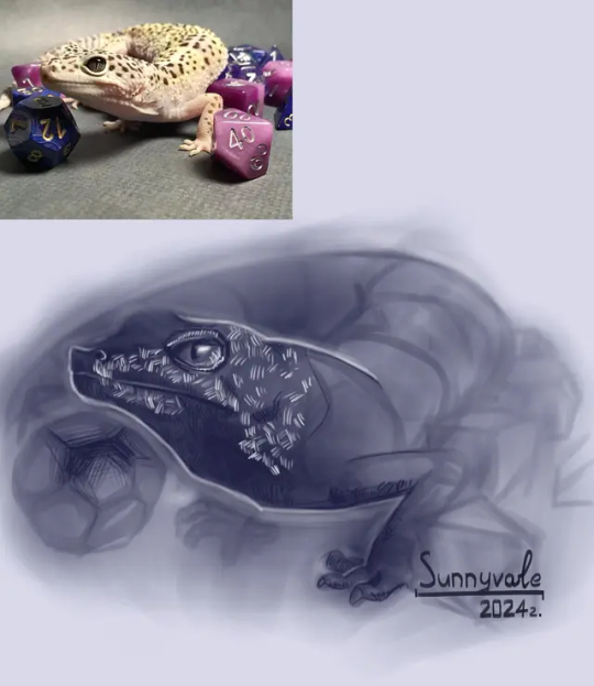
And practice from a training assignment.
2020 -> 2024 year.
0 notes
Text
Creating Backgrounds
This week Vanessa, Illustration, talks with us about illustrating backgrounds for her drawings as she takes us through her battle with finding a style in creating an atmosphere for her characters. #MarywoodArt #Illustration #CharacterDesign #background

View On WordPress
#aerial perspective#Art#assignment#backgrounds#blur#character central#class#cohesive#depth#designing characters#details#Digital Design#drawing#edit#Illustration#inspiration#Marywood Art#Marywood Art Department#Marywood University#Marywood University Art Department#Painting#Where Creativity Works
0 notes
Text

maybe we could talk about it
#ooooough...... single-handedly the most detailed and time-using piece in my sketchbook the whole summer#this look me like 4 days off and on#they drive me fucking insane so they deserve it <3#had to wait until like 3:30 to get a good picture with the sunlight and it still didn't turn out spectacular#but i take what i can get🫶#tried going for a partial aerial (?) weird perspective shot so alhaitham looks wonky#but whatever#natlan coming.... less time for these two...... this is a hate crime#anyway tag time#alhaitham#kaveh#kavehtham#haikaveh#genshin impact#traditional art#art tag#gonna be posting some more doodles soonish so stay tuned🔥‼️🔥‼️‼️
71 notes
·
View notes
Text


(guy who is normal about traveler abroad voice) hey man how's it going
#tai sui#太岁#had a tag saying everyone who can spot the cousins in the first one in less than 5 seconds gets a cookie#but i realised they show up clearer in the scan so everyone gets a cookie for free :) 🍪🍪🍪🍪🍪#the first one was supposed to be aerial perspective practice but then i noticed the tree trunks kinda looked like willows and. well.#please imagine the leaves in your mind's eye i had to erase them because the sketch looked too messy otherwise </3#the shiyong one was supposed to be a traditional piece but i fucked up big time while inking#moped around for a couple weeks#and finally resigned myself to painstakingly try and fix it digitally#i feel kinda insane for putting so many hours into such a simple piece but we stay silly👍#xi ping#xi shiyong#zhou ying#prince zhuang#traveler abroad#tai sui spoilers#my art#my tai sui art#🍀
31 notes
·
View notes
Text

Back from hiatus - didja miss me? Startin' off strong with a warm, hazy city based on Oreste Mercado's inspiring photography! Thanks for looking, and as usual, stay tuned for the process video next week!
#landscape#landscape painting#digital landscape#architecture#city view#building#buildings#city#warm#orange#cityscape#summer#perspective#urban#street#road#aerial#digital art#visual development#background painting#background design#background#illustration#allisonperryart#allison perry
15 notes
·
View notes
Text

It's all about perspective.
2 notes
·
View notes
Text
Adam Sills’s well-written and beautifully produced Against the Map is in some ways a strange book to review [...] [from the disciplinary perspective of environmental studies]. Sills shows little interest in environmental history or ecocriticism, even in the “ecology without nature” mode [...]. His basic argument is that cartography, because of print capitalism, seeped into all sorts of facets of life on the British Isles during the late seventeenth and eighteenth centuries. It became something that playwrights, novelists, and creative nonfiction types, like Samuel Johnson, developed spaces of resistance to in their publications. Sills highlights the political nature and problematic historical genealogies of maps, an argument that has broader implications for [contemporary] environmental historians who use maps to convey [relatively more “objective” and/or “scientific” information] [...].
Sills begins by accepting the idea, derived from Ben Anderson’s comparative work, that “the history of the map and the history of the modern nation state are inextricably bound up with each other” (p. 1). He then cites two of the key analysts of this in relation to Britain: Richard Helgerson on the literary nationalism of the English Renaissance and John Brewer on the fiscal-military state of the eighteenth century, with its army of surveyors and excise tax collectors. In this historiography, the “surveyor emerges as an authorial figure,” key to the making of the modern state as distinct from traditional dynastic and ecclesiastical authority (p. 3). Combined with cheap printing, the result was what Mary Pedley has called a “democratization of the map” (p. 4). [...]
---
For John Bunyan, the “neighborhood” became a site of resistance (as it is for Denis Wood in his 2010 Everything Sings: Maps for a Narrative Atlas). [...]
For Aphra Behn, [...] the theater and “built environment” of the “fragmented, chameleonlike ... scenic stage” had the ability to challenge coherent representations of the Atlantic empire produced by maps like those of world atlas publisher and road mapper John Ogilby (p. 65).
From Dublin, Jonathan Swift directly satirized the cartographic and statistical impulses of the likes of William Petty, Henry Pratt, and Herman Moll, who all helped visualize London’s colonial relationship with Ireland [...].
From London, Daniel Defoe questioned efforts to define what precisely makes a market or market town through maps and travel itineraries, pointing toward the entropic aspects of the market (“its inherent instabilities and elusive nature”) that challenged and escaped efforts to stabilize such spaces through representations in print (p. 163).
Johnson’s travels to Scotland redefined surveying, resisting the model put forward by the fiscal-military state in the aftermath of the Jacobite Rebellion of 1745.
---
The final chapter and conclusion, “The Neighborhood Revisited,” looks at Jane Austen’s Mansfield Park (1814), a classic novel of the artificial environment of the estate garden. By the early nineteenth century, neighborhoods were more like gated communities and symptomatic of Burkean conservatism and nostalgia. But in Austen’s hands, their structures of affect also suggest the limits of the controversial map- and data-centric literary methodologies [...] and perhaps more broadly the digital humanities. “The principle of spatial difference and differentiation, the heterotopic conceit, always remains a formal possibility, not only at the margins of the empire but at its very center as well,... a possibility that the map cannot acknowledge or register in any fashion” (p. 234). For Sills, this is true of eighteenth-century mapping as well as the fashion for “graphs, maps, and trees” in the early twenty-first century.
---
Sills’s basic argument, that a certain canonical strain of English literature - from Bunyan to Austen - positioned itself “against the map,” seems quite solid. He makes this point most directly by appealing to the work of Mary Poovey on the modern “fact,” with the map as “a rhetorical mode ... that serves to legitimate private and state interests by displacing and, ultimately, effacing the political, religious, and economic impact of those interests” (p. 91).
Nevertheless, returning to a[n] [exclusively] canonical, Bunyan-centered, “small is beautiful” neighborhood approach [potentially ignoring planetary environmental systems, the global context, in cartography] seems limited and problematic from the perspective of Anthropocene [...]. The global maps and mathematics used by the likes of Edmund Halley and Isaac Newton, which were directly satirized by Swift in the Laputa section of Gulliver’s Travels (1726), did something different than Petty’s mapping of Ireland. High-flying as they may have been, such maps and diagrams were key to the development of [...] environmental thinking by Charles Darwin, Charles Lyell, Alexander von Humboldt, and others in the nineteenth century. More recently, global mapping [...], like the internet closely tied initially to the modern American fiscal-military state, have [also later then] been essential to identifying processes of climate change, ocean acidification, deforestation, dead zones, sea level rise, desertification, and a host of other processes that would otherwise be challenging to perceive. This is no mere “Vanity Fair.” Sills’s book would have benefited from engaging with Jason Pearl’s Utopian Geographies and the Early English Novel, published in 2014 [...]. Pearl also does close readings of Behn, Defoe, and Swift, choosing Margaret Cavendish instead of Bunyan and stopping in 1730, just before things became picturesque but just after they were financialized by the South Sea Bubble, Newton’s mint, and Robert Walpole. Pearl reproduces maps by Defoe of Robinson Crusoe’s global travels and of Crusoe’s island, Swift of Houyhnhnmland, Ambrosius Holbein of Thomas More’s Utopia [...].
What if rather than “against the map,” we are seeing struggles between radical and conservative cartography [...] engaged in a fight over the future (utopia)?
What if what [...] [some have] called “capitalist realism” [...], what might in the eighteenth century be called “nationalist realism,” is not the only thing happening with maps and the imagination?
---
Text above by: Robert Batchelor. “Review of Sills, Adam, Against the Map: The Politics of Geography in Eighteenth-Century Britain.” H-Environment, H-Net Reviews. May 2023. Published online at: h-net,org/reviews/showrev,php?id:58887. [Bold emphasis and some paragraph breaks/contractions added by me. In this post, all italicized text within brackets added by me.]
#hmm lot going on here pretty thoughtprovoking for a review#i have lots of thoughts about radical potential of maps for conception of planetary scale and antiimperialism#though simultaneously must remain critical of panopticon aerial perspective of satellite imagery as batchelor says originating with usempire#to acknowledge radical alternatives to imperial mapping in nineteenth century#instead of namedropping humboldt and darwin and chauvinist racist figures i wouldve pointed to#exslaves and abolitionists and their use of global scale conceptions to frame revolutionary atlantic and international solidarity#anyway#abolition#ecology#colonial#imperial cartography#tidalectics#geographic imaginaries#carceral geography#debt and debt colonies#british mapping
19 notes
·
View notes
Text
So the English version of G-Witch's OP The Blessing/Shukufuku was released and like I haven't seen anyone mentioning it
youtube
it's pretty great
#The Blessing#Shukufuku#YOASOBI#gundam the witch from mercury#G-witch#gwitch#the witch from mercury#gundam suisei no majo#gundam#gundam aerial#<- technically cus it's sung from her perspective#I think#could be misremembering#samusmaximus.posts#Youtube
22 notes
·
View notes
Video
Espace-Milieu : Painting as Environment by Russell Moreton
Via Flickr:
Aerial Social Mappings. Winchester Cathedral : Space for Peace 2011. russellmoreton.blogspot.co.uk/
#blueprint#paper#painting#light#process#chemistry#printing#anthropology#observation#involuntary#presence#building#footprint#outline#cathedral#event#space for peace#russell moreton#aerial#perspective#mapping#occupancy#precision#indeterminacy#intimate biography#sedimentation#a-discursive ---practice-#melancholia#psychosis#state
6 notes
·
View notes
Photo


aerial/ atmospheric perspective
1 Constable (1776-1837) English Wivenhoe Park (1816) oil on canvas 56.1×101.2cm
2 artist unknown
Atmospheric, or aerial perspective, creates the sense of distance in a painting by utilising the fact that the atmosphere appears more blue in the distance. tate.org.uk
1 note
·
View note
Text

working on some new storyboarding projects to practice a more intentionally feature-focused style! the differences between TV and feature boarding are fascinating, and I love doing visual explorations like these that can grow my skill and my portfolio :) specifically, I am trying to implement some very cool cinematography by playing with the camera in some of these sequences ! stay tuned <3
#it is an aerial view so it might take a sec to figure out#but i had a lot of fun playing the perspective with this shot so i could try a more dramatic cut into the sequence#i am attempting to make three new sequences under 100 panels to practice with the feature style#one of the others is about my dog being sooooo silly#and the other is about my bestie and her children being the most chaotic ever#artstudent#appalachianartist#art student#digital art#portfolio#cartoon#characters#sketch#concept#digital artist#storyboard pro#storyboard#storyboard artist#storyboard art#story art#storyboard internship#storyboard artist internship#AURA
3 notes
·
View notes
Photo


“Skyscraper”. Oil on canvas, 70 x 120 cm, 2022. This original painting is available for sale at the price of 2650 US$, shipping is worldwide free. Contact me in case you are interested in more information about my work, or the availability for work on graphics.
#skyscraper#city#landscape#building#buildings#geometry#perspective#painting#aerial#surreal#virtual#oil painting#contemporary art
2 notes
·
View notes
Text
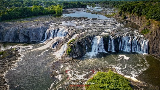
#DroneShots DRONEshotMedia 🌊✨ Experience the Majestic Cohoes Falls from Above! ✨🌊
Captured by Drone Shot Media#these stunning aerial photographs showcase the breathtaking beauty of Cohoes Falls. The powerful cascade of water#framed by lush greenery and the serene flow of the Mohawk River#is a sight to behold. Dive into nature’s wonder and feel the rush of the falls from a whole new perspective! 🌿📸
CohoesFalls DroneShotMed
0 notes
Text
Process video from last week's warm, hazy city based on Oreste Mercado's awesome photography - thanks for looking!
youtube
#landscape#landscape painting#digital landscape#architecture#city view#building#buildings#city#warm#orange#cityscape#summer#perspective#urban#street#road#aerial#digital art#visual development#background painting#background design#background#illustration#process#process video#tutorial#allisonperryart#allison perry#Youtube
3 notes
·
View notes
Last Seen Blogs
uberstip
iSteve

47pictures
47Pictures

221bphotography
Photography

aquatxt
Welcome to whatever this is

gaming-beast
Gaming Beast