#bike maps
Text
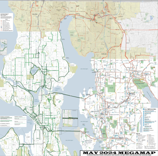
So not only did I finish the Greater Northshore Bike Connector Map to connect the Seattle and Eastside maps, I decided I would ALSO make a MEGAMAP of all three maps since King County stopped maintaining a map over 10 years ago which makes this the biggest maintained King County bike map since then.
Greater Northshore Bike Connector Map (May 2024)
May 2024 MEGAMAP (Northshore May 2024, Seattle EOY 2023, 2 Line Eastside April 2024)
let's gooooooooo!
#biking#maps#bike maps#seattle#northshore#shoreline#lake forest park#kenmore#bothell#woodinville#juanita#kirkland#bellevue#redmond#bike map
23 notes
·
View notes
Text


maxes doodles so cute ...
#💬#this is the map of the philippines isnt it ? i know they went there that one time#i mean . the burning flaming skull was there too . i guess#i forget if the bike thing happened there too or not tho
70 notes
·
View notes
Text
due to my very specific collection of bandanas, I am only able to signal interest in Skeleton Sex, Tie-dye Sex, Tentacle Sex, and Sex on a Bicycle, Specifically In Berkeley.
#news from the cupola#skeleton bandana; tie dye bandana (dubious); tentacle bandana; bike trail map of berkeley bandana...#...I am not in fact interested in any of those. Ever.
72 notes
·
View notes
Text
Features I would like to get from my map sites
SHOW ME THE BUS LINES ON THE MAP PLEASE
Let me adjust my walking speed. I walk slowly. I am not fast. If the bus is in 7 minutes, and you say the walk is a 5-minute walk I am not making that bus.
Let me permanently mark places and roads on my map. Like, I want to see where is Ben's house every time I open the city map. I don't want to remember
Let me also permanently mark roads. and other shit. Let me put notes on places like "scary dog lives here" and "closes at 19:00"
MARK THE PATHS WITHOUT SHADES AT ANY SPECIFIC TIME AND LET ME AVOID THEM WHEN GOING ROUND THE CITY I SWEAR THIS WOULD MAKE MY LIFE BETTER
Show an "Is this road accessible by bike/wheelchair" marker.
Show parking space estimation. Also for bikes.
Let me have a separate road system with the bike and walking shortcuts. Also, sweetie, I know it's illegal, but I am driving on the sidewalk, I don't need to go on the direction of the road.
Just have a better interface please? Like, yours genuinely sucks (looking at you Google Maps! what is this abomination?)
Also let me theme the map? I want it to look like parchment please? It would make walking feel cooler.
Google Maps specifically, you already track all my friends' location. Let us share it around? like make groups that can view each other? no need for a new app.
add your own, I am sure there are more
#david original#urban life#cityscape#urban landscape#city#urban#city to live in#not just bikes#maps#geography#google maps
32 notes
·
View notes
Text
Do I Really Want This Medal
#there's a challenge map leave me alone!!!#this is ass!! this is terrible!!! jesus on his infamous bike!!!!#arknights
66 notes
·
View notes
Photo

All the bike lanes in the Netherlands.
418 notes
·
View notes
Text
Rolling With Difficulty as texts I have saved on my computer for some reason
(i drew every day for like a month straight and burnt out so have this nonsense instead)
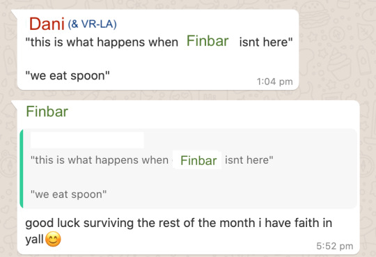

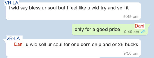

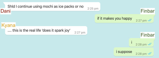
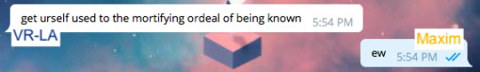
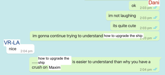
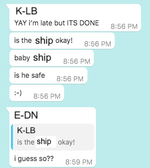
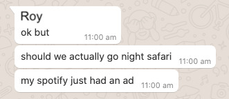
#rolling with difficulty#dani rwd#finbar rwd#kyana rwd#vrla rwd#vr la rwd#which of those is the correct tag. like genuine question#k lb rwd#maxim rwd#i had one that was k-lb and c-ra but it got eaten by tumblr somehow#anyway sorry for the wildly varying formatting these are amassed across like 4 years and god knows how many messaging apps#if you want context to 'we eat spoon' me and my friend bought a bean curd and for some reason we thought the spoon was made of like#that biodegradable/technically edible plastic material#i mean idk what it was actually made of but it sure as shit wasnt edible because i was the one who tried#same friend is the one who almost died on a highway with me because we misread google maps and tried to push our bikes#along a highway shoulder for 30 minutes at like... 12 in the morning#selling your soul for 25 bucks is a joke from when i was playing fallen london and actually sold my soul in game for about that much#im realising now that i may very well be the dani of my friend group and i have no idea how to feel about that#the original of the crush on maxim one was me @ my arospec ace friend who loved making fun of me for my dumb crushes#so it was like. my one rare chance to take revenge because while they were Suffering with that *i* was studying for a competition! lmao#i should do these more often like i do these for all my fandoms and its always a blast every time
58 notes
·
View notes
Text


Ritual Collection:
{Credit} - {Credit} - {Credit}
{Credit} - {Credit} - {Credit}
{Credit} - {Credit} - {Credit}
#stimblr#visual stim#stim#stimboard#gifset#stim gifs#goth stim#my gifs#stim gif#brown#biking#parkour#map#tattoo#taxidermy#puppet#special effects#shoes#fashion#coffee#blood bag#mushroom#lip sync#castle
18 notes
·
View notes
Text

TRACTOR BIKE
(and Ryss' karakul herd and @verysmallcyborg's Fornax)
#TRACTOR BIKE#sorry i am excited about the tractor bike#ffxiv#gpose#ryssrael#fornax#FUN FACT#if you move a 2 seater mount while someone is in gpose... it interrupts the gpose#rip renee i thought it'd be really funny if i drove to the other side of the map and you came out of gpose in a totally different place#☀️🌟
26 notes
·
View notes
Text
Since there were no notes, RC1 of the Greater Northshore Bike Connector Map is the release! This map connects the City of Seattle maintained bike map (latest EOY 2023) and the new 2 Line Connector Map on the eastside, covering northwest King County.
The biggest addition to this version is an entire new category of routes showing where people bike when there isn't bike infrastructure in place. It's particularly useful in rural King County, but is also helpful a few other places, like Lake Forest Park, and it also shows how infrastructure "islands" connect together in real life.
#seattle#bike map#bike maps#king county#shoreline#lake forest park#kenmore#bothell#biking#bike#woodinville#juanita#redmond
4 notes
·
View notes
Text
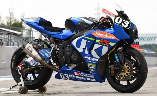
Suzuki GSX-R1000 | Moto Map Team | 2017
#motorcycle#suzuki#gsxr1000#moto map team#sport bike#racing#motorsports#ride hard or go home#built for speed#experience speed#2017#moto love#lifestyle
15 notes
·
View notes
Text
I'm building a town for my new Kids on Bikes campaign (Tittled Definitely Not ScoobyDoo) and I've just spent the afternoon drawing a map of the town of Midday Mills

It's a very rough map and absolutely not to scale but hopefully my players will appreciate the visual representation rather than my half baked word pictures
#kids on bikes#dnd#dnd art#maps#ttrpg community#ttrpg#ttrpg art#game master#dungeons and dragons#artwork#art#digital art
3 notes
·
View notes
Text
they've conspired to make my commute to work longer and stupider
#also really dont like the new look of maps#this is how they win and get me to bike to work. big sigh
4 notes
·
View notes
Text
I slept rly deeply last night even tho it took me a while to get to sleep but I think that was bc I had acid reflux and I'd been playing videogames too late not anything else.... still only got 6 hrs but doing pretty okay all things considered 😚
#and not feeling sick this morning so im sticking w the higher dose for one more day. my heart rate does feel a little uncomfortably fast#but its tolerable. just gonna make notes of how it goes through the day and ill submit my review form to my dr this evening#and hopefully she'll give me the green light to drop back down instead of continuing to titrate up#this is making me think of those heartrate fetishists... do u think i could make money selling tachycardic heart recordings online#i do wanna try to exercise this morning while i have energy. might take the bike out it looks like a gorgeously sunny day#maybe ill try to map my cycle route to work so i can consider cycling there instead of taking the bus in a couple weeks..#i cant atm thp cuz they have scaffolding up and its blocked off the bike racks sadly 😔#i think making myself eat + drink as much as i can has helped control the nausea too. just need a lot of fuel to process meds properly ig#and a lot of sleep.. its a bit stressful to think abt how rigid im going to have to be abt my daily routines if i want to stay medicated#but to be honest i have a pretty rock solid sleep/meal routine already bc its the only way i can function with the hours i work#so like. i dont rly need to worry too much. i think i reacted badly the first couple days bc my base anxiety was high#and then bc that feeling was heightened by meds -> made me not eat/sleep properly -> knock on sickness the next day#but yeah still the side effects arent very nice and i dont wanna take the risk of it exacerbating every difficult emotion i deal with#but fingers crossed bc 30 worked rly nice for me and i had barely any side effects so hopefully i can settle w that long term 🤞#we will see....#ANYWAY. sorry for making the same post over and over the last couple days. talking abt it on here has helped me feel a lot calmer#i dont wanna bother ppl irl w every thought and physical symptom i experience hourly. but this is my blog i can do what i want#hope everyone else has a nice sunday <3#.diaries
5 notes
·
View notes
Text
my post about the baby eating a tomato at the farmer's market has elicited mostly very positive reactions but there have been a couple of comments (since the containment breach) along the lines of "and then everyone clapped." and obviously I have no plans to question the authors of those comments but I am genuinely curious about what part of that story seems implausible to them. the tomato guy giving a baby a tomato for free? a baby happily eating a tomato? bystanders finding a tomato-eating baby adorable?
like it's a cute story sure but it doesn't seem all that credulity-straining to me. it's like if I said "so cozy in bed right now in my jammies" and some random stranger was like "suuuuure you are 🙄"
(I am. btw)
#psir#also someone was like 'i would not have stopped and said aww. i would have kept walking. to me babies eating messily is gross'#i was like... ok well i'm glad you told me. otherwise i might have come to your house with the baby and knocked on the door#and made you watch him eat a tomato#it's like on google maps when people are like 'does this location have a bike rack' and someone goes 'i don't know'#...then i wasn't talking to you???#anyways i shouldn't cavil. almost nobody has gotten really weird and hostile on the nephew posts
65 notes
·
View notes
Text
oughhhh one thing they do not tell you about the journey there is that you also have to make it back
#not ouaw related#I tried to bike to a library but my maps app lied to me#so the library I was going to did not actually exist#I tried to go to the next one#but didn’t realize how far it was until i physically could not go on anymore#tw for nausea and vomiting for the next tags#I gaslit myself into thinking the exhaustion was somehow Fake#and got so exhausted that I threw up ON MY BIKE#then just sat next to it on the side of a highway while cars gawked#which I’m pretty sure is a circle of hell probably#made it to the library at least!!!#but now I am dreading making it back#I think having an Odyssean mindset about this might make it easier#I am only halfway through the journey#FUCK THERES A BEE ON MY LEG WHAT THE FUCK#bee’s gone! we’re good#journey time
2 notes
·
View notes
Last Seen Blogs

loodje
Lover of Mature

xfjhsrj
无标题

rustyhopes
❝ Je ne sais quoi ❞
lifune
Lifune

verstap-it
you're on your own kid