#MapChart
Explore tagged Tumblr posts
Visit Tumblr Blog
Explore Tumblr blogs with no restrictions, modern design and the best experience.
Last Seen Tumblr Blogs


Fun Fact
When “GIF” was named word of the year in 2012, Oxford Dictionaries U.S.A. credited Tumblr for pushing the word.
Text
Transforming Your Presentations: How Graphs and Maps Enhance Audience Engagement
Data Visualization: Common Queries Answered
1.How do I arrange graphs in PowerPoint?
To arrange graphs in PowerPoint, first select the graph you want to move. Use the "Format" tab to adjust its position and size. You can also right-click the graph and choose "Send to Back" or "Bring to Front" to layer it correctly. To align multiple graphs, select them while holding the Shift key, then use the "Arrange" options in the "Format" tab, such as "Align," "Group," or "Distribute." Finally, drag and drop the graphs to your desired location on the slide for a clean layout.
2. How to make a map chart in PowerPoint?
To create a map chart in PowerPoint, follow these steps:
1. Open PowerPoint and create a new slide.
2. Go to the "Insert" tab and select "Chart."
3. Choose "Map" from the chart options.
4. Input your data in the spreadsheet that appears.
5. Customize the map chart by adjusting colors, labels, and styles in the "Chart Tools" menu.
6. Resize and position the chart as needed.
7. Save your presentation.
This will create a visual representation of your data on a map.
3. How to get world map on PowerPoint?
To add a world map to PowerPoint, open your presentation and go to the slide where you want the map. Click on "Insert" in the top menu, then select "Pictures" or "Online Pictures" to find a world map image. Alternatively, you can use SmartArt by selecting "Insert," then "SmartArt," and choosing a suitable layout. Another option is to use the "Map" feature in PowerPoint, available in some versions under "Insert" > "Chart" > "Map." After inserting the map, you can resize and customize it as needed.
4. How do I create a map in Word PPT?
To create a map in PowerPoint, follow these steps:
1. Open PowerPoint and select a blank slide.
2. Go to the "Insert" tab and click on "Shapes" to choose a map shape or use the "SmartArt" feature for more complex layouts.
3. Customize the shape by resizing, changing colors, and adding text.
4. For a more detailed map, consider inserting an image of a map and use "Shapes" to highlight or annotate specific areas.
5. Use the "Format" tab to adjust styles and effects.
6. Save your presentation.
5. How do you create a building map in PowerPoint?
To create a building map in PowerPoint, follow these steps:
1. Open PowerPoint and select a blank slide.
2. Use the "Insert" tab to add shapes like rectangles and lines to represent rooms and corridors.
3. Arrange and resize shapes to match the building layout.
4. Use the "Text Box" tool to label rooms and areas.
5. Customize colors and styles via the "Format" tab for clarity.
6. Group elements by selecting them, right-clicking, and choosing "Group."
7. Finally, save your slide as a template for future use.
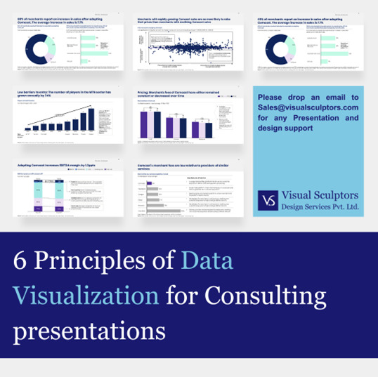
Visit: VS Website See: VS Portfolio
0 notes
Text
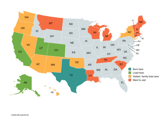
Saw someone's mapchart of states they had visited and got inspired ^-^ really made me realise how much of this country I haven't seen yet. I want to visit the Great Lakes more than anything.
Born here: Texas Lived here: California, Colorado, Alaska, Utah Visited / family lives here: Washington, Oregon, Nevada, Arizona, New Mexico, Oklahoma, New York Want to visit: Montana, Wisconsin, Michigan, Louisiana, Tennessee, South Carolina, Vermont, New Hampshire, Maine, Massachusetts, Connecticut, Rhode Island
0 notes
Text
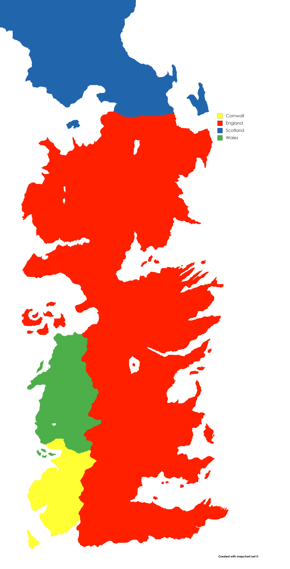
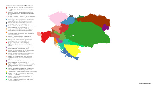
My map I made of the First level subdivisions of the Cisleithania and Transleithania, made in Mapchart.
0 notes
Text
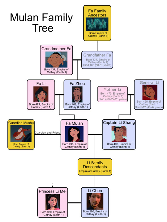
Mulan Family Tree
Pictured below is the family tree for Fa Mulan a long while before 434 AD to 980 AD.
495 AD
Fa Mulan is born to two loving parents. A mother named Fa Li and a father named Fa Zhou. The family (including Grandmother Fa) resides on a beautiful farm in a small village in The Empire of Cathay.
511 AD
Now 16, Fa Mulan goes to see the Matchmaker in hopes of being titled a "perfect bride". Unfortunately it goes horribly wrong and she is cast out by the Matchmaker. She swiftly returns home distraught where her father comforts her. Doubly unfortunately, the Emperor's Counselor has arrived to conscript one man from every household to fight a rising Rouran invasion. Unwilling to let her injured father go to war, Mulan takes his place.
On the way to the war camp Mulan is startled by her guardian Mushu. He is going to help her become a war hero (unbeknownst to her), and help keep her alive. At the war camp Mulan comes up with the masculine name, Fa Ping and immediately makes enemies of her fellow conscripts. General Li leaves with all the experienced soldiers to fight Shan Yu. It is now up to Captain Li Shang to train all the inexperienced soldiers for battle. Li Shang shoots an arrow on top of a pole and tells the soldiers that they will need discipline and strength (represented by two weights) to reach the arrow. Over the next couple of months Mulan and her fellow soldiers become friends and get quite proficient during training. All of this culminates when Mulan retrieves the arrow and the army is summoned to the front lines by "General Li".
512 AD
The army passes through many villages on the way to meet General Li. Their carefree attitude is dashed upon seeing the burnt village and the massacre where Li Shang's father is found dead. The army then heads for the Tung Shao Pass in hopes of meeting Shan Yu and his Rouran army before they reach the Imperial City. Unfortunately Mushu sets off a cannon exposing their position to Shan Yu and his army. In a move both brilliant and idiotic, Mulan buries the entire Rouran army under an avalanche by shooting a cannon at a nearby mountain. Unfortunately Mulan is injured and it is revealed that she is actually a woman pretending to be a male soldier. Instead of being executed for high treason, Li Shang spares her life and leaves her in the mountain pass.
Mulan decides to go home but spots a small group of Rouran (including Shan Yu) that survived the avalanche making their way to the Imperial City. She races to intercept Li Shang to warn him but is met with indifference and coldness. She is ultimately proven right when the surviving Rourans kidnap the Emperor and lock themselves in the Palace. Mulan quickly devises a plan and is joined by Li Shang and her three friends to rescue the Emperor. The group manage to knock out the Rouran guards and free the Emperor. Unfortunately Mulan is chased by Shan Yu onto the roof. Mulan uses her ingenuity to instead trap him on the roof and Mushu uses a firework to finally kill Shan Yu.
Mulan is offered a position on the Emperors Council but declines. So instead the Emperor gives Mulan his medallion so her family will know what she has done for him and Shan Yu's sword so the world will know what she has done for the Empire of Cathay. She returns home and is met by her father who immediately embraces her. Li Shang arrives not long after in hopes of starting a relationship with Mulan.
520 AD
After many years of seeing the Empire, discovering what makes her happy, and being employed as the Emperor's Councilmember, Mulan and Shang marry and start a family.
980 AD
Another prominent figure is born in the Li family, descended from Fa Mulan and Li Shang named Li Chen.
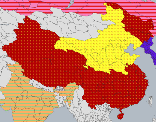
The Empire of Cathay (~2070 BC – 1911 AD) to China (1911 AD – Present)
Pictured below is the approximate geographical map for the Empire of Cathay in 511 AD.
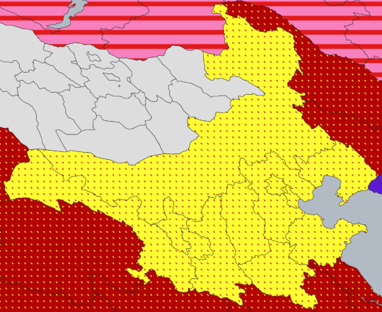
This Empire was founded in ~2070 BC and has gone through many different names and changes from that time. The most recent of which takes place in 1911 AD with the dissolution of the Empire and the formation of the country; China (pictured below; the red with yellow dots and the yellow with red dots).
Additional Information
I have spent almost two years on this massive project now and I'm so glad I can finally share it! Mulan was quite difficult to add to the tree as she is Chinese and most Disney characters are white. I eventually found a loophole after adding non-Disney characters after running out of Disney characters to add and getting bored. Mulan was picked to go first via the poll that was done so I'll do the rest of the Princess's on the poll in their popularity order. I'm also new to Tumblr so let me know if the formatting is weird and needs improving. Thanks for reading!
#mulan#disney princess#disney#family tree#disney movies#Disney family tree#li shang#mushu#alternate universe#alternate history#still a work in progress#I've been working on this for years#I'm a Disney historian now#Family Echo my beloved#Google Docs my beloved#MapChart my beloved#Inkscape my beloved
18 notes
·
View notes
Note
Trump attempting to acquire Greenland and Canada would be funny and speed up the collapse of the US. But I don't think it would actually end up happening, like most things that aren't exploitation and horrific violence against impoverished populations. What are your thoughts?
I don't think it's likely, is not the first time Greenland has been sized up by a US presidency, though the pressure to get some control over the arctic appears to be increasing. Either way, this whole thing is very reminiscent of the endless amount of maps you'll find on reddit and twitter made in photoshop or mapchart, of a possible reorganization of this or that country, or of the Union of vast regions into one superstate. Playing with maps is fun, I do it sometimes too, but that's what that is, it's play. The fact that all borders are artificial to some or other degree is irrefutable. But what some people fall into is in giving these games actual weight. These fantastical maps always betray the sensibilities of the map maker, with some sentimentalist, identitarian or historicist justification behind it, explicit or not. These are tics, tics of a mentality stuck in the 19th century or in grand strategy map games, that believes that if we just got the shape of the administrations of capitalism right it will all be fine. No problem has ever been solved by reconfiguring lines on land and sea. The priorization or abandon of certain territories by capitalist development is an unbreakable rule, unable to be fixed by a balance of power of carefully divided administrations named after an early medieval duchy or a 19th century nationalist separatist movement.
The US already has control over that side of the arctic, Canada and Denmark are both in NATO, and one way or another the potential profits from an arctic maritime passage will find their way to wall street.
73 notes
·
View notes
Text
stumbled across this mapchart detailing the military strength of the kingdoms. and once more i am angry that the show shat on the reach as a military power house
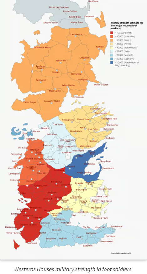
"Did we fight well." "eh, as well as can be expected" "it was never our forte" Like yea, just walk into the biggest kingdom, with the thinly stretched lan army, brush off any defence, instant access to their capital, no siege needed. coz the reach is full of flower fearies who dont know which way to point a sword.
7 notes
·
View notes
Text
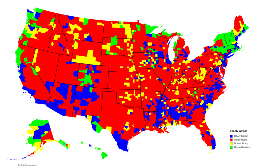
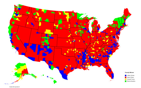
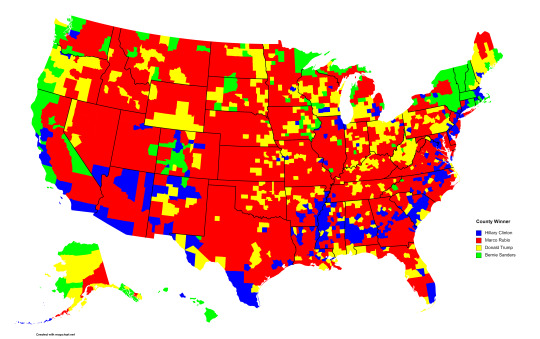

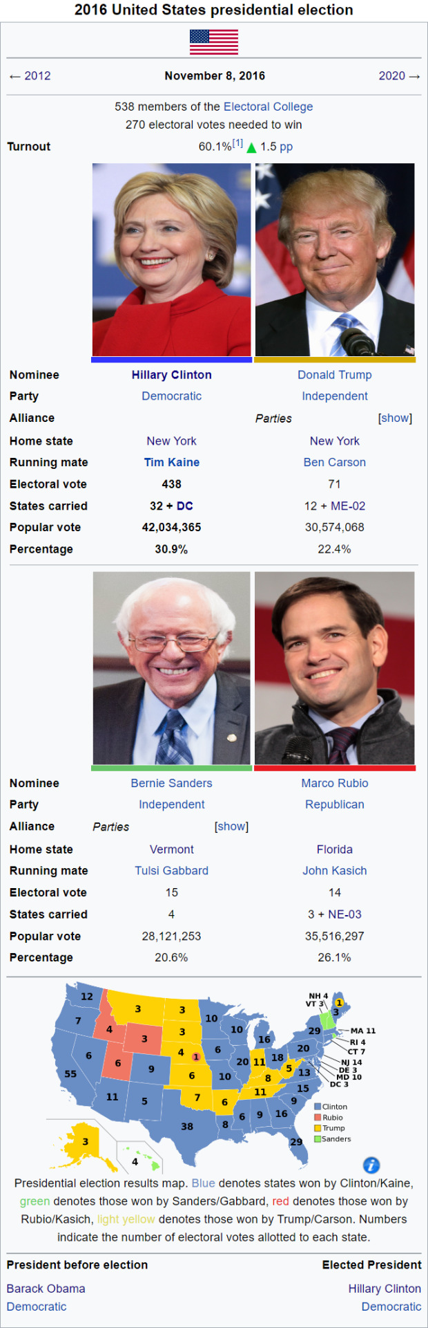
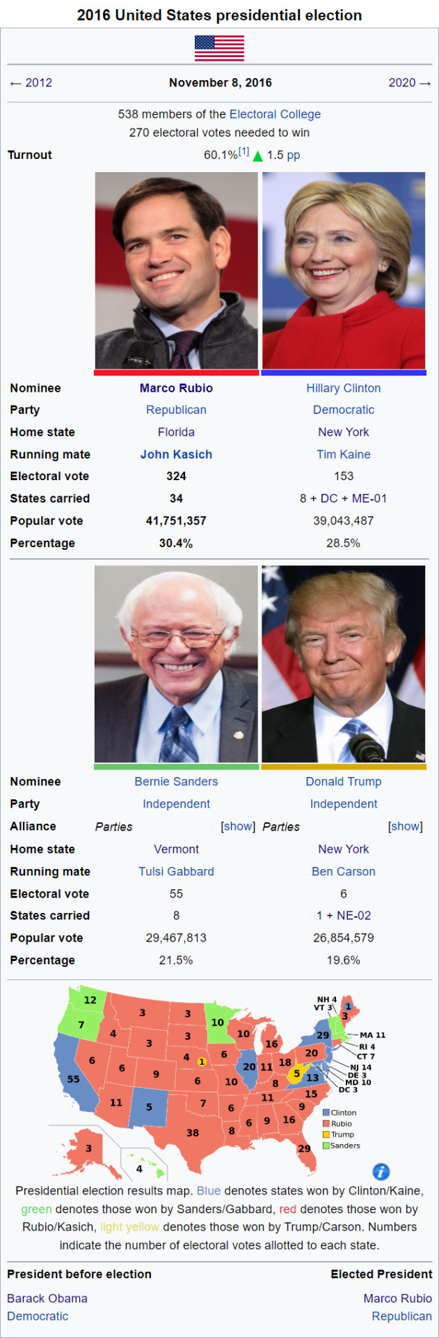
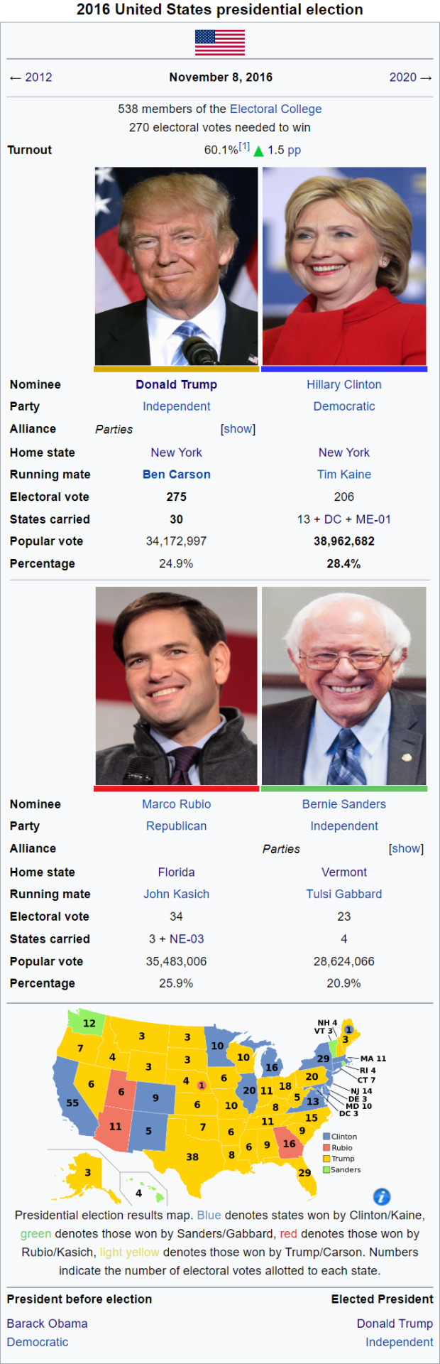
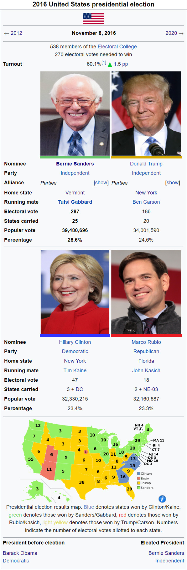
I have done it. After about a month or so of on and off working on this, I have completed county level maps for each of these 4 scenarios based off of the 2016 4-way redux New Campaign Trail mod. These maps correspond to a Clinton, Rubio, Trump, and Sanders victory respectively.
If you want a glimpse into what I did for this, here you go:
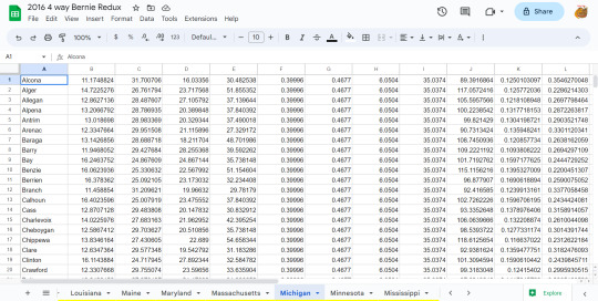
The math I did for this was that I took the in game state margins, then divided those by the real life margins. I then multiplied this by the county level margins, and then added all 4 of them up, then divided them by those same multiplied margins, before multiplying them by 100 so they looked good. I used the Libertarian party for Trump, and the Green party for Sanders. In NV, SD, and OK, the Green party didn't have ballot access, so I used "No Party" in NV, and the Democratic party for SD and OK. I probably should have used the constitution party or something for Trump, since using the Libertarian party means that he was strongest in the suburbs, which is the exact opposite of where he was strong, but oh well. I don't feel like changing the results now. I may have fudged some of the numbers a little bit to make it look better imo, but that's just how politics works baby.
Also if you want, you can try to guess the margins in each of the states.
Also I used mapcharts just because it was the easiest to use. I could try making a Wikipedia style map, but I do this stuff manually, so that would probably take 6 months or something, and I also don't know what colors I'd use for Trump and Sanders.
#us politics#alternate history#2016#2016 4 way#map#political map#the campaign trail#nct#new campaign trail
3 notes
·
View notes
Text
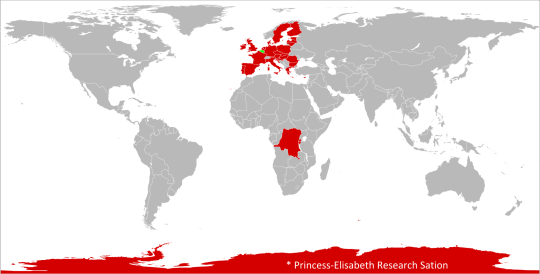
Anachronous Map of the Belgian Empire (1876-Present), including Brussels' European Union, the Kingdom of Belgium, the Antarctic Treaty Lands, the Princess Elisabeth Antarctica Research Station, the Congo and the Territory of Ruanda-Urundi, made with MapChart by the user 'max1me' of Imgur
https://imgur.com/gallery/belgian-colonial-empire-bQnPrpd
🇧🇪
#belgium#belgian#belgian empire#belgian colonial empire#Belgianempire#belgiancolonialempire#belgique#belgian history#belgian colonialism#belgian imperialism#history#colonial history#colonialism#colonisation#colonization#colonial era#european colonialism#european colonization#europe#europa#european history#european imperialism#Kingdom of Belgium#belgian congo#dr congo#congo#Congo free state#leopold ii#king leopold#Ruanda-Urundi
0 notes
Link
Comment créer gratuitement et sans inscription une carte personnalisée avec MapChart J'ai toujours pensé que lorsque l'on présentait quelque chose, la forme était au moins aussi importante que le contenu, surtout si le contenu est de qualité ! Alors lorsqu'il s'agit de présenter des cartes, le web regorge de supers outils pour afficher des données. Parmi ceux-ci, MapChart se présente comme une super solution pour quiconque souhaite créer des cartes personnalisées, que ce soit pour des projets scolaires, des présentations professionnelles ou simplement pour le plaisir de partager avec des amis. Qu'est-ce que MapChart ? MapChart permet aux utilisateurs de concevoir des cartes de différentes régions du monde et de colorer les pays ou les états selon divers critères. Cet outil en ligne est entièrement gratuit et ne nécessite aucune inscription. Il propose également une version "Plus" pour ceux qui désirent des fonctionnalités plus avancées. L'un des atouts majeurs de MapChart c'est que l'outil propose une vaste sélection de fond de carte du monde entier. Vous avez ainsi le choix entre plusieurs cartes du mondes, des cartes des différents continents, mais également des fonds de carte de la plupart des pays du monde. Pour chaque type de carte vous pouvez également choisir son niveau de découpage : pays ou encore régions et provinces. Mais MapChart ne se limite pas à la cartographie du monde réel. Pour les fans d'œuvres de fiction (comme Europa Universalis IV, HElder Scrolls ou Game of Thrones), la plateforme offre également des cartes de fantasy et la possibilité de créer des scénarios d'histoire alternative, parfaits pour les jeux ou les études éducatives. Westeros - Game of Thrones Avec MapChart, tu peux colorier pays, états et régions selon tes besoins, ce qui est idéal pour les projets éducatifs, les présentations et l'analyse de données. Attention, toutes les cartes créées sur MapChart sont soumises à une licence Creative Commons (Partage dans les Mêmes Conditions 4.0 International) qui permet leur utilisation et distribution libre, à condition de créditer l'auteur et de partager avec la même licence libre. Comment créer une carte personnalisée sur MapChart Étape 1 : Accédez à MapChart depuis votre navigateur web. Sur la page d'accueil, dans le menu du haut, vous trouverez une large gamme de cartes à sélectionner allant des cartes du monde entier à des cartes de pays spécifiques et de régions. Étape 2 : Sélectionnez le type de carte que vous souhaitez personnaliser (vous pouvez par exemple regardez ce que l'outil propose dans les cartes d'Europe) et choisissez le modèle spécifique de carte au sein de cette catégorie. Aucune connexion n'est nécessaire pour accéder à la carte et la modifier. Étape 3 : Une fois la carte sélectionnée, vous pouvez personnaliser son apparence en cliquant sur le bouton 'UI' (Interface Utilisateur). Là vous allez pouvoir modifier l'interface de l'outils pour votre confort. A cet endroit vous pouvez également sélectionner un jeu de couleur de carte (terre/mer) prédéfini. Étape 4 : Vous pouvez maintenant ajoutez des informations sur la carte : colorier des pays (chaque couleur ajoutera une légende personnalisable à la carte), customiser les couleurs du fond de carte et des frontières, ajouter les noms des pays, afficher ou masquer les frontières, customiser l'affichage de la légende (police, couleurs, forme...)... Étape 5 : Une fois satisfait de votre travail, vous pouvez sauvegarder et partager votre carte. MapChart propose plusieurs options de téléchargement en cliquant sur "Download Options...". Vous pouvez ainsi modifier les dimensions de la carte en pixels mais également choisir le format de sortie : PNG, JPG ou SVG. Cliquez ensuite Download Map pour télécharger votre carte ou sur Save/Load Map Configuration si vous souhaitez conserver votre travail pour pouvoir le rééditer plus tard. Importer des données depuis Excel et Google Sheets Pour les utilisateurs avancés, MapChart offre une fonctionnalité particulièrement utile (et gratuite) pour les professionnels et les universitaires : la capacité d'importer des données directement depuis des feuilles de calcul Excel et Google Sheets. Cette fonction permet aux utilisateurs de mapper des informations spécifiques et de les appliquer visuellement sur la carte sélectionnée ; ainsi, un utilisateur pourrait charger des données économiques, par exemple, et observer leur distribution géographique en quelques clics.
0 notes
Text
It was made on MapChart, which is pretty fiddly, but they did get Palestine there, so why not Israel?
From my research(activity page) I can tell that half of Tumblr users are either from Brasil or Chicago
8K notes
·
View notes
Text
Shitty recreation of what roman lands the eastern roman empire controlled
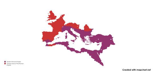
made on mapchart
PS if PM Seymour, OZ media, Emkay, or Bettina Levy, or anyone of the sort voice this, that'd be my dream lol
(This was made like 8 months ago)
0 notes
Text
Create map charts with 3D shadow effect via paintmaps.com
5 notes
·
View notes
Text
messing around on mapchart with the power of polls!
0 notes
Photo
Even if that was done for ease of making on MapChart, then:
1: Belgium, Switzerland (And Luxembourg?) should be striped yellow and red.
2: The UK and Ireland should be striped yellow and another colour, labelled as 'Celtic' (I'd rather say do Gaelic and Brittonic, but I don't think you can do three stripes)
3: France should be striped yellow and the Celtic colour.
4: Spain has a language isolate (Basque), so that should probably be under 'other', and therefore striped red and white.
And probably more. That's just all I know.

Language families in Europe
by switzermaps
166 notes
·
View notes
Photo

🏀𝔹𝕖𝕟𝕔𝕙 𝕆𝕟 𝕒 ℚ𝕌𝔼𝕊𝕋: 𝔾𝕝𝕠𝕓𝕒𝕝 ℙ𝕣𝕖𝕤𝕖𝕟𝕔𝕖 🌎🌍🌏 We thankfully present our latest Fan Map update! 🗺️ Fans from more countries have joined us! Thank you for your support! 😤 Can you spot your country?? ❓ If you do, it means someone there supports @BenchOnaQUEST! And if you don’t... What are you waiting for? Show some international support! #BenchOnaQUEST ➖➖➖➖➖➖➖➖➖➖ #ClipperNation 🔵🔴 #LAourWay #CLIPSET ⚓ #LAClippers 🏀 #ClippersBasketball #map #mapchart #mapping #worldmap 🌍 #data #stats #geography @mapchart 🗺️ @diversetravel_ #maps #flags #geography 🗾 #infographic #LosAngelesClippers #LAClippersPolska (at Los Angeles, California) https://www.instagram.com/p/CjSfOb9s-UH/?igshid=NGJjMDIxMWI=
#benchonaquest#clippernation#laourway#clipset#laclippers#clippersbasketball#map#mapchart#mapping#worldmap#data#stats#geography#maps#flags#infographic#losangelesclippers#laclipperspolska
1 note
·
View note