#satellite image service
Video

flickr
GOES-U Launches to Space by NASA on The Commons
Via Flickr:
A SpaceX Falcon Heavy rocket carrying the National Oceanic and Atmospheric Administration (NOAA) GOES-U (Geostationary Operational Environmental Satellite U) lifts off from Launch Complex 39A at NASA’s Kennedy Space Center in Florida on Tuesday, June 25, 2024. The GOES-U satellite is the final satellite in the GOES-R series, which serves a critical role in providing continuous coverage of the Western Hemisphere, including monitoring tropical systems in the eastern Pacific and Atlantic oceans. On board GOES-U is a suite of seven instruments for collecting advanced imagery and atmospheric measurements, providing real-time mapping of lightning activity, and detecting approaching space weather hazards. Also onboard for the first time is the compact coronagraph that will observe the Sun’s outermost layer, called the corona, for large explosions of plasma that could produce geomagnetic solar storms. NASA Media Usage Guidelines Credit: NASA/SpaceX Image Number: KSC-20240625-PH-SPX01_0016 Date: June 25, 2024
#NASA#KSC#Kennedy Space Center#LSP#Launch Services Program#GOES-U#Geostationary Operational Environmental Satellite#spacecraft#weather satellite#GSFC#NOAA#National Oceanic and Atmospheric Administration#Advanced Baseline Imager#Magnetometer instrument#SpaceX#Falcon Heavy rocket#Lockheed Martin#L3Harris Technologies#flickr
0 notes
Text
The Israeli military has destroyed nearly 200,000 housing units, either completely or partially, since the start of its latest assault on the Gaza Strip following Hamas's surprise attack on October 7.
Mohammad Ziyara, the Palestinian minister of public works and housing, said on Thursday the bombardment has "erased entire families from the civil registry,", as well as "neighbourhoods and residential communities".
"[It] also destroyed facilities, including hospitals, places of worship, bakeries, water filling stations, markets, schools, and educational and service institutions,” Ziyara added in a statement.
Home to some 2.3 million people, the Gaza Strip covers a tiny area of 365sq km (141sq miles).
According to the UN's humanitarian office, at least 45 percent of all housing units in the enclave have been damaged or destroyed in the Israeli attacks. Among the areas hit the hardest have been Beit Hanoon, Beit Lahiya, Shujaiya, the neighbourhoods around the Shati refugee camp, and Abasan al-Kabira in Khan Younis.
An estimated 1.4 million people in Gaza have been internally displaced due to the relentless bombardment, with some 629,000 sheltering in 150 UN-designated emergency shelters.
Meanwhile, Israel's total blockade on fuel entering the enclave is seriously affecting critical functions in all hospitals, risking the lives of at least 130 premature babies in incubators, 1,000 kidney dialysis patients who have had to reduce their treatment sessions, and front-line ambulance workers who cannot access the sick when the fuel runs out.
Since 2007, when Hamas came to power, Israel has maintained strict control over Gaza’s airspace and territorial waters and restricted the movement of goods and people in and out of the enclave
If you click on the article, you'll be able to see the before and after pictures of Gaza. The sheer devastation is mind boggling
3K notes
·
View notes
Text
It’s not over yet! May 11/12 aurora watch continues
It was a good night for aurora watchers all over Europe on the evening of May 10th/11th, 2024. Here's a great brief timelapse video sequence from Berkshire in the UK (via @Rainmaker1973 over at the Bye Bye Birdie place).
Among numerous other displays, this particular broad, pink "banner" structure was widely observed across the UK and Ireland around midnight local time / 2300 UT. It persisted, twisting and morphing into a variety of new shapes, for something like half an hour. The night's display as a whole was definitely one for the record books.
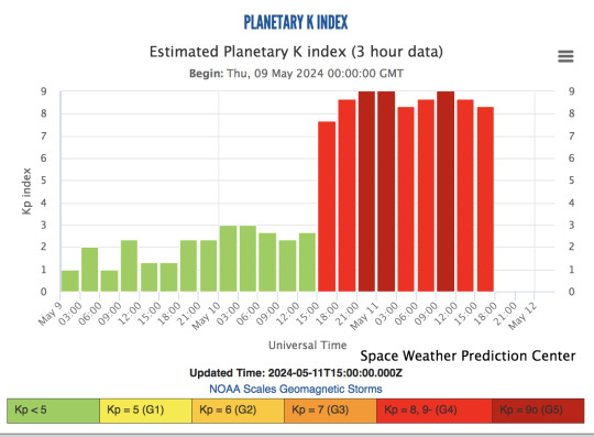
The early projections at the NOAA site suggest that the power of the incoming geomagnetic storm will be significantly less on Sunday, May 12th. But the night of May 11th still holds possibilities, as for the time being the storm seems to be holding at the relatively high Kp 8 level (on a scale of 0-9).
NOAA space weather forecasters have observed at least seven coronal mass ejections (CMEs) from the sun, with impacts expected to arrive on Earth as early as midday Friday, May 10, and persist through Sunday, May 12, 2024.
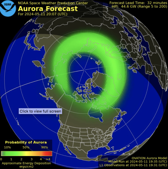
Here are the early graphic projections for the zone of visibility on the evening of May 11 2024. Please note that (a) these are approximations and estimates, not hard and fast indicators of where the solar wind makes planetfall; and (b) as they did last night, they may well improve over the course of the day as newer and better data reaches the predicting devices and personnel.
The European animated projection comes via ITV (UK) weatherman Chris Page.
North American prediction images come via the Space Weather Prediction Center at the NOAA website. Right now (9:30 PM IDT / 2139 UT on May 11th) the NOAA's evening prediction animation for Europe and North America hasn't been generated yet. This still image (updated 1900 IDT) shows where the auroral viewing zone stands right now. The "likelihood of viewing" for Europe seems to have dropped pretty much into the 30-40% range.
That said, though, it's worth noting that the NOAA earlier issued yet another geomagnetic storm watch warning for 12 May, as the Sun apparently popped off both X-class and M-class flares early today; the effects of those are now in transit toward Earth. So we'll see in a day or so what comes of that. Sunspot region 3664, which has been responsible for all this excitement, is plainly not done spitting out flares just yet.
As regards tonight's predictions, it also remains to be seen whether what we get will be better... considering that last night's displays far outpaced everybody's expectations. I for one am quite willing to be surprised. 🙏
It's also worth noting here that so far today, the Kp index illustrated at the Space Weather Prediction Center's experimental aurora dashboard page—an indicator of the current strength of the geomagnetic storm—hasn't dropped off very much from last night's highs. It'll be interesting to see how this behaves as the day goes on. (ETA 2: image updated 11/05/2024, 2140 IDT)
Other useful resources for those interested in space weather generally, and solar weather:
NASA's SOHO (Solar and Heliospheric Observatory) satellite's "The Sun Now" page
ESA Space Weather Service Network
NOAA (US National Oceanic and Atmospheric Administration) Space Weather and Prediction Page
OVATION auroral prediction model from the DSCOVR spacecraft, via SpaceWeatherLive
AuroraWatch UK
1K notes
·
View notes
Text
Maui Fires & How to Support Relief Efforts
(Posted on 8/10/23)
Hi, I'm Jae and my family is from Lāhainā. I watched my hometown burn down this week.
The fires caused immeasurable loss in my community so I'd like to spread awareness of the situation as well as provide links to support local organizations directly assisting survivors. I'm pretty sure most of my following is Not local so I'm writing with intent to inform people outside the situation, but if you're reading this and happen to have family in the affected area that isn't accounted for, message me and I can send you the links to the missing persons tracking docs + more localized info!! If you'd like to skip down to how to help and follow community organizations, scroll to the bottom of the post after the image.
Earlier this week, Hurricane Dora passed south of the Hawaiian Islands, bringing strong wind gusts that caused property damage across the islands. On Tuesday August 8, high winds caused sparks to fly in the middle of Lāhainā town, knocking out power lines and immediately igniting drought-ridden grasses. The fire spread quickly and destroyed the entire center of town, the harbor, and multiple neighborhoods including Hawaiian Homes (housing specifically for Native Hawaiians), parts of Lahainaluna, basically all of Front Street, and low-income housing units. There is only one public road in and out of town, and after a very hectic evacuation period that road has been mostly closed off except to emergency responders, thus it is extremely difficult for anyone to leave town to get help. The nearest hospital is 20 miles away in Wailuku, and most grocery stores in town have burnt down.
As of Thursday, August 10, over 1,000 acres have been burned and 271 structures (including homes, schools, and other community gathering places) have been destroyed. Cell service is still extremely spotty, many of the surrounding neighborhoods deemed safe for evacuees are still without utilities. There are currently confirmed 53 deaths but that number is expected to increase as search-and-rescue efforts continue. Countless families have been displaced and many have lost the homes they lived in for generations. Places of deep historical significance have been reduced to ash, including the gravesites of Hawaiian royalty, the old Lāhainā courthouse where items of cultural significance were stored, and Na ‘Aikane o Maui Cultural Center.
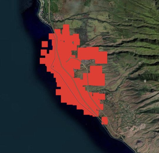
To add further context: Lāhainā has a population of about 13,000 residents. EVERYONE I know has been impacted in some way--at best forced to evacuate, at worst their house was burnt to the foundation, they cannot find a loved one, etc. I'm still trying to track down family members and it's been over two days. My neighbors down the street had homes last week and now many don't have ANYTHING. The hotels are taking in residents (tourists are also being STRONGLY urged to leave so that locals can recover). Without open access to the rest of the island, Lāhainā residents are now dependent on whatever people had in their homes already as well as disaster relief efforts coming in, but it's been difficult to organize and mobilize due to the location + conditions. People who have made it out are in shelters where no blankets or medicine were provided. Friends and acquaintances from neighbor islands are preparing aid to send over. Community response has been incredible, but the toll on the town has been immeasurable. My parents were desperately walking through town yesterday, my mom sounded absolutely hollow talking about it on the phone with me. It's horrifying. Below is a satellite map with data from the NASA Fire Information for Resource Management System showing the impacted areas from the past week; all of the red blotches were on fire at some point in the last three days.
Here are ways you can help:
If you have the means to donate:
Here are three donation sites verified by Maui Rapid Response, which also lists FAQs for people who are wondering about next steps.
Hawaiʻi Community Foundation - Maui Strong Fund accepts international credit cards.
Maui United Way
Maui Mutual Aid
Non-monetary ways to support:
If you know anyone who is planning to travel to ANY Hawaiian island, not just Maui, tell them to cancel their trip. Resources are extremely limited as is.
Advocate for climate change mitigation efforts locally, wherever that is for you. The fire was exacerbated by drought conditions that have worsened due to climate change.
Lastly, remember that these are people's HOMES that burned, and Native Hawaiian cultural artifacts that have been lost. Stop thinking of Hawaiʻi (or any "tourist destination" location, really) as an "escape" or a "paradise." If that's the only way you recognized my home... I'm glad I got your attention somehow, but I would ask that you challenge that perspective and prioritize local and native voices.
For transparency, I don't currently live in Lāhainā, I've been following efforts from Honolulu. My parents and brother have been updating me and I've been following friends and family who are doing immediate response work. I'm doing my best to find reliable and current sources, but if I need to update something, please let me know. If you're going to try to convince me that tourism is necessary for our recovery, news flash ***IT'S NOT***!
Thanks for reading.
#please feel free to reblog! i don't know how tagging works here anymore!#maui fires#officially reported death count increased WHILE I WAS WRITING THE POST btw. this is bonkers.#if you want to start tourism discourse in my inbox you have to donate the cost of a plane ticket and send a screenshot to me#i have sources at the ready btw. i'd say don't try me but i mean my hometown could use a couple hundred bucks!!
982 notes
·
View notes
Text
Calling Long-Distance: 10 Stellar Moments in 2022 for Space Communications and Navigation
Just like your phone needs Wi-Fi or data services to text or call – NASA spacecraft need communication services.
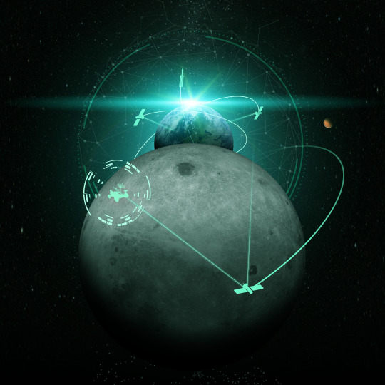
Giant antennas on Earth and a fleet of satellites in space enable missions to send data and images back to our home planet and keep us in touch with our astronauts in space. Using this data, scientists and engineers can make discoveries about Earth, the solar system, and beyond. The antennas and satellites make up our space communications networks: the Near Space Network and Deep Space Network.
Check out the top ten moments from our space comm community:
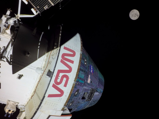
1. Space communication networks helped the Artemis I mission on its historic journey to the Moon. From the launch pad to the Moon and back, the Near Space Network and Deep Space Network worked hand-in-hand to seamlessly support Artemis I. These networks let mission controllers send commands up to the spacecraft and receive important spacecraft health data, as well as incredible images of the Moon and Earth.
The Pathfinder Technology Demonstration 3 spacecraft with hosted TeraByte InfraRed Delivery (TBIRD) payload communicating with laser links down to Earth. Credit: NASA/Ames Research Center
2. Spacecraft can range in size – from the size of a bus to the size of a cereal box. In May 2022, we launched a record-breaking communication system the size of a tissue box. TBIRD showcases the benefits of a laser communications system, which uses infrared light waves rather than radio waves to communicate more data at once. Just like we have upgraded from 3G to 4G to 5G on our phones, we are upgrading its space communications capabilities by implementing laser comms!
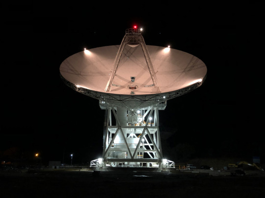
3. The Deep Space Network added a new 34-meter (111-foot) antenna to continue supporting science and exploration missions investigating our solar system and beyond. Deep Space Station 53 went online in February 2022 at our Madrid Deep Space Communications Complex. It is the fourth of six antennas being added to expand the network’s capacity.
4. You’ve probably seen in the news that there are a lot of companies working on space capabilities. The Near Space Network is embracing the aerospace community’s innovative work and seeking out multiple partnerships. In 2022, we met with over 300 companies in hopes of beginning new collaborative efforts and increasing savings.

5. Similar to TBIRD, we're developing laser comms for the International Space Station. The terminal will show the benefits of laser comms while using a new networking technique called High Delay/Disruption Tolerant Networking that routes data four times faster than current systems. This year, engineers tested and proved the capability in a lab.

6. In 2021, we launched the James Webb Space Telescope, a state-of-the-art observatory to take pictures of our universe. This year, the Deep Space Network received the revolutionary first images of our solar system from Webb. The telescope communicates with the network’s massive antennas at three global complexes in Canberra, Australia; Madrid, Spain; and Goldstone, California.
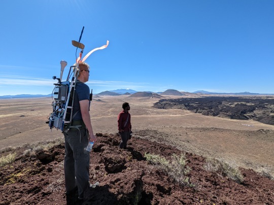
7. Just like we use data services on our phone to communicate, we'll do the same with future rovers and astronauts exploring the Moon. In 2022, the Lunar LTE Studies project, or LunarLiTES, team conducted two weeks of testing in the harsh depths of the Arizona desert, where groundbreaking 4G LTE communications data was captured in an environment similar to the lunar South Pole. We're using this information to determine the best way to use 4G and 5G networking on the Moon.

8. A new Near Space Network antenna site was unveiled in Matjiesfontein, South Africa. NASA and the South African Space Agency celebrated a ground-breaking at the site of a new comms antenna that will support future Artemis Moon missions. Three ground stations located strategically across the globe will provide direct-to-Earth communication and navigation capabilities for lunar missions.

9. Quantum science aims to better understand the world around us through the study of extremely small particles. April 14, 2022, marked the first official World Quantum Day celebration, and we participated alongside other federal agencies and the National Quantum Coordination Office. From atomic clocks to optimizing laser communications, quantum science promises to greatly improve our advances in science, exploration, and technology.
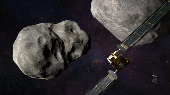
10. We intentionally crashed a spacecraft into an asteroid to test technology that could one day be used to defend Earth from asteroids. The Double Asteroid Redirection Test, or DART, mission successfully collided with the asteroid Dimorphos at a rate of 4 miles per second (6.1 kilometers per second), with real-time video enabled by the Deep Space Network. Alongside communications and navigation support, the global network also supports planetary defense by tracking near-Earth objects.
We look forward to many more special moments connecting Earth to space in the coming year.
Make sure to follow us on Tumblr for your regular dose of space!
1K notes
·
View notes
Photo

Sandstorms of the coast west coast of Africa
Easterly winds blew across Namibia in July 2023, lofting bands of dust across the coastal plains and out to sea. Streams of tan-colored dust jetted out from the entire length of Namibia’s coast and parts of the southern Angola coast when the Moderate Resolution Imaging Spectroradiometer (MODIS) on NASA’s Aqua satellite captured this image on July 11. In addition, a streak of white salt dust from the Etosha Pan swept across the northern part of Namibia.
The pattern is not unusual for this time of year, when hot, dry squalls known as berg winds rush down from the interior highlands. In 2023, the warm east winds set in on July 6, picking up dust from the desert and salt pans and sending it toward the coast.
By the time this image was acquired, the dust and sand had created poor visibility and hazardous driving conditions in some coastal towns, including Walvis Bay. According to news reports, heavy machinery was needed to clear sand drifts from roadways.
The Etosha Pan, the distinct bright rectangular patch in the image, is an expansive salt flat roughly 130 kilometers (80 miles) long and 50 kilometers (30 miles) wide. It is typically dry except for brief periods in the summer months, when flamingos and other aquatic congregate there. At the time of the image, winds had carried the salty dust approximately 300 kilometers (180 miles) toward the Atlantic.
The windy conditions were forecast to persist in coastal and interior regions for several days, with the possibility for more sandstorms, according to the Namibia Meteorological Service. However, compared with Saharan dust storms that are large enough to influence hurricane formation and ultimately the weather on the opposite side of the Atlantic, the amount of dust in southern African storms is negligible.
259 notes
·
View notes
Note
if you want to answer (and i totally understand if you dont), who do you think bombed the hospital in gaza? ive seen a lot of different people talking about it and blaming different people & organizations and you seem like you know a lot aboit i/p
IMPORTANT TO NOTE: i am not a news source. i am some guy with access to the internet. please follow the links in this post, as well as doing your own research. please do not use social media posts exclusively as your source of news, and please continuously read and compare several different accredited news sources. keep on top of new sources and evidence that are being put out to ensure that you have the most up-to-date information.
it's not really about who i think did it. i feel like that centers me in a thing that is very much not about me. but i'll give it my best shot.
we still do not have confirmation of how many were killed or who is at fault for the bombing. there are a lot of numbers and opinions floating around online, but as of 4pm on october 19th there has not been a consensus on either of these things from any accredited organizations.
that being said, here are the statements that have been put out as of the time i'm responding to this:
statements about death toll:
the gaza health ministry estimates between 200 and 471 dead
the director of al-shifa hospital where people were brought from al-ahli estimates 250 dead
an assessment from the us director of national intelligence estimates between 100 and 300
an analyst with the center for naval analysis, after viewing photos and video, said the death toll was closer to 50
statements about fault:
(taking these directly from the article)
J Andres Gannon, an assistant professor at Vanderbilt University, in the US, says the ground explosions appeared to be small, meaning that the heat generated from the impact may have been caused by leftover rocket fuel rather than an explosion from a warhead.
Justin Bronk, senior research fellow at the UK-based Royal United Services Institute, agrees. While it is difficult to be sure at such an early stage, he says, the evidence looks like the explosion was caused by a failed rocket section hitting the car park and causing a fuel and propellant fire.
Mr Gannon says it is not possible to determine whether the projectile struck its intended target from the footage he has seen. He adds that the flashes in the sky likely indicate the projectile was a rocket with an engine that overheated and stopped working.
Valeria Scuto, lead Middle East analyst at Sibylline, a risk assessment company, notes that Israel has the capacity to carry out other forms of air strike by drone, where they might use Hellfire missiles. These missiles generate a significant amount of heat but would not necessarily leave a large crater. But she says uncorroborated footage shows a pattern of fires at the hospital site that was not consistent with this explanation.
Visual evidence from the blast site
The BBC was able to match details of buildings and the layout of the Al-Ahli hospital site with publicly available satellite imagery, to establish the hospital was the scene of the blast.
Based on available evidence, it appears the explosion happened in a courtyard which is part of the hospital site. Images of the ground after the blast do not show significant damage to surrounding hospital buildings. What the images do show are scorch marks and burnt-out cars.
where the explosive came from
so far, israel, hamas, and palestinian islamic jihad have all denied responsibility
channel 4 news reported that palestinian islamic jihad had uncovered a warhead but they have not produced it
in a since-deleted tweet, hananya naftali, a social media advisor for netanyahu, claimed that it was an israeli airstrike that hit the hospital. he followed up by stating that he had shared incorrect information based on a reuters headline that refered to an israeli airstrike
tentative conclusion based on sources:
what i gather from what i've read is that the blast was likely caused by a misfired rocket originating somewhere in gaza, and the blast was exacerbated by the fuel in the rocket. BUT, as i stated before, new information is always being put out. there could be evidence released tomorrow that it was an israeli air strike. there has been no conclusive evidence yet.
and perhaps the most important section:
what you can actually do to help
if you are in the us, call your representatives and urge them to support the resolution for a ceasefire
check out this list of verified aid groups (if there is not a ceasefire as soon as possible, it won't matter what aid is sent to them and if they cannot get the supplies into gaza, so refer back to the first bulletpoint)
send a donation to your local synagogue(s) and mosque(s) to help them offset the rising costs of security
take a moment to be a human. don't think about the numbers. don't think about the politics. think about the human beings who lost their lives, and the people who are mourning them. the mothers who will never see their children again, the children who will grow up without parents. what did they have for breakfast? what was their favorite song? when was their birthday? were they afraid? were they in pain? what can we do to ensure this does not happen again?
135 notes
·
View notes
Text
7x03 analysis part 2 — Too many Cats
Tommy flew a helicopter into a Category 5 hurricane, at least the show told us so. Is it even possible for an aircraft to fly in those conditions? Today, we are going to figure out just how strong the storm actually is canonically, and how realistic our beloved weewoo show is.
TW: Hurricane, extreme weather, natural disaster
What is the difference between a tropical storm and a hurricane? What even is a hurricane?
Both tropical storm and hurricane are tropical cyclones, just of different strength. A tropical cyclone is a rotating storm system with a low pressure center. The center, or the eye of the storm, sucks in warm moist air from an oceanic environment and it feeds into the generation of storm clouds that organize themselves into a spiral pattern due to the Earth's rotation, aka Coriolis effect.

A tropical cyclone is classified by its maximum sustained wind.

So if it's below 62 km/h, it's a tropical Depression. if it's between 63-118 km/h, it's a Tropical Storm. A Category 5 hurricane though has a maximum sustained wind speed of over 252 km/h.
A strong enough tropical cyclone is called a hurricane in North America, a typhoon in East Asian, and a cyclone in the Indian Ocean (including Australia).
How strong is the storm in 7x03 actually?
We first see the storm at the end of 7x01, when First Mate Kenneth tells Captain Ochoa there is a strengthening tropical storm in the ship's path. Captain Ochoa decides to reverse course back to LA and instructs Kenneth to alert the Coast Guard, but they get interrupted by the cartel.

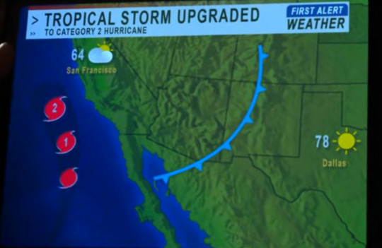
Fast forward to 7x02, the next mention of the storm comes from Karen. When Hen is sent home by Chief Simpson, she tries to call Athena, but it goes straight to voicemail. Karen tells her cell service is probably spotty out at sea because of the hurricane, which has just got upgraded.
It's recently upgraded to a Category 2 hurricane, as we can see from Karen's tablet.
Then Hen goes to Maddie to ask the Coast Guard to look for Bathena's cruise ship. When Hen shows Maddie the ship tracking app on her phone, the time is 10:28. (I'm guessing PM because it's already dark outside during the Kyle Ortiz call.)

By the time Chief Simpson comes by to reinstate Hen, she's already talking about a Cat 5 hurricane. That can't be more than an hour or two later.

So which one is it? Is it a Cat 2 or a Cat 5? Who should I trust?
Tommy. Whenever he flies, his safety depends on his understanding of the local wind condition and weather. You should listen to him:
So it's a Cat 5, at least by the time the 118 set off on their journey to save Bathena.

Can a tropical storm intensify into a Cat 5 hurricane in hours?
No, not in real life. The record for most rapid intensification of a tropical cyclone is Hurricane Patricia in 2015, but it still took 24 hours. This doesn't mean the storm in 7x03 is completely made up. I believe I might have found the real life inspiration behind it.
Hurricane Otis (2023)
An area of low pressure formed on October 15, 2023 over the Pacific Ocean off the coast of Mexico. While it was during a significant El Niño period and the ocean temperature was record-breaking-ly high, strong vertical wind shear condition near the storm was predicted to hinder its development. It was originally forecasted to make landfall as a mere tropical storm. People in Acapulco went to bed on October 23 expecting moderate wind and light rainfall, many stopped seeking out updates of the storm.
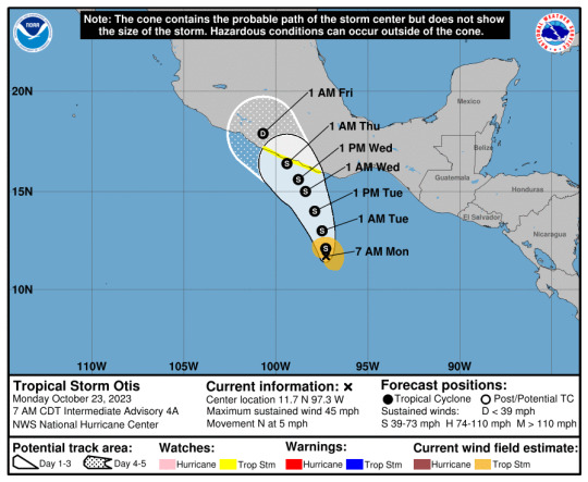
In the early hours of October 24, meteorologists at the NHC recognized from satellite images that tropical storm Otis was rapidly intensifying into a hurricane. The NHC officially upgraded the storm to a Cat 1 hurricane at 13:00 CDT and sent out a hurricane hunter aircraft to accurately measure the actual wind speed of the cyclone.
youtube
Satellite images provide a pretty good model to estimate the strength of a tropical cyclone, but the most reliable way to measure wind speed is still to fly an aircraft into it and physically measure it. When the hurricane hunter managed to fly into the eyewall of Otis, everyone realized they made a huge mistake: Otis had already become a Cat 3 hurricane, and it was expected to strengthen even more. It takes time to process data received from the hurricane hunter, so operationally the NHC still classified Otis as a Cat 1 hurricane until the next advisory was scheduled to come out, which was at 16:00 CDT, but by that time, Otis was already near Cat 4 strength. It was then officially upgraded to a Cat 5 hurricane at 22:00 CDT.

While Otis did take around 24 hours to intensify from a tropical storm to a catastrophic hurricane, if you just look at the NHC advisories, it pretty much jumped from a Cat 1 into a Cat 5 in 9 hours. It caused extensive damage to Acapulco when it made landfall because the city was severely underprepared. I suspect the cruise ship disaster arc was inspired by hurricane Otis because it happened just a month after the writer strike ended. Also, in 7x02 Maddie, a 911 dispatcher, was not aware that the tropical storm had already strengthened into a hurricane, which mirrors the unexpected development of hurricane Otis.

As the storm in universe was going back at sea and not making landfall, the authority was probably in even less of a hurry to find out what the actual strength of the cyclone was. So it could take them even longer to send in weather reconnaissance aircrafts. I can imagine the 911-verse version of the storm jumping from a Cat 2 to a Cat 5 officially in mere hours.
Can a helicopter fly in a Cat 5 hurricane?
Technically yes, but the chopper won't be doing the flying. The aforementioned NOAA Hurricane Hunter is a Lockheed P-3 Orion specifically modified and fortified for weather information collection. If this four-engined workhorse has to fight tooth and nail against crosswind and turbulence in order to fly into the eye of the storm, a small single engine helicopter definitely would not fair any better. It would end up getting tossed around, a particular strong downdraft might slam it into the ocean, or a prolong bout of severe turbulence might rip it apart. Luckily in 7x03, Tommy is not actually flying into a hurricane, he's trailing behind it.

NOAA Lockheed WP-3D Orion Hurricane Hunter
In a blink-and-you-miss-it exchange between Buck and Tommy, after Tommy says "a Cat 5 hurricane passed through here", Buck asks why he means by "passed through" and what they are flying in at the moment.

"iNTermITteNt sHOweRs"

When looking at the cross section of a tropical cyclone, you can see rows of rainbands around the eyewall, increasing in size the closer it is to the center of the storm. If you have ever experienced a tropical cyclone making landfall, you would know it starts with sporadic bouts of rainfall (aka intermittent showers), which then gradually increase in frequency and severity as the storm approaches. Once you are within 100-200 km of the eye, wind speed would become violent while the rainbands become so wide and close together it basically keeps raining until you are right under the eye.
These are radar images of hurricane Irma (2017) making landfall in Florida. Bands of moderate to heavy rainfall spread across the inner core region of the cyclone, with still pretty consistent light to moderate precipitation between the gaps. But in the area further away from the eye in the southwest and southeast quadrants, you can see more squall line like patterns. Precipitation would abruptly begin and stop as you fly in and out of those outer lumps of clouds.
Wind speed in that area is no where near hurricane level even for a Cat 5 cyclone, it is typically under 100 km/h. That does not mean it is a safe condition to fly in. Because the outer rainbands of a cyclone are less affected by the storm's vortex dynamics, they behave more like regular thunderstorms. As you know, thunderstorms are big no-no's for aviation safety. In fact, the outer rainbands of a typhoon once contributed to a plane crash in Taiwan.
Conclusion
The hurricane in 7x03 is likely based on reality, albeit with a bit of exaggeration and a shortened timeline for dramatic effect. It is possible to fly and control a helicopter in this specific condition, but the danger is still quite high. Flying into a thunderstorm has a whole different set of risks associated with it, which I will tell you all about next time. Yes, part 3 of this series is "how to crash a helicopter with weather", so stay tuned.
#not a professional#but storm tracking is my cultural heritage#i'm never beating the dweeb allegation#911 abc#911 meta#tommy kinard#tagging the ship for fic reference#bucktommy#tevan#kinley#TW: hurricane#TW: extreme weather#TW: natural disaster
38 notes
·
View notes
Note
Recent Chicago peice reminded me of the way Chicago north suburbs use military bases to divide and segregate in a manner that similarly matches connects to colonial actions. You always compile interesting stuff thank you.
Thank you for the kindness and support. I'm gonna riff on this a little bit. I'm sorry, I don't mean to distract from what you specifically brought up here.
Yea, we can add federal military base sites to the list of significant "innovations" Chicago has made in race-based labor segregation in service of wealth extraction. (For anyone following along, the article/essay we're discussing explores racism and white anxiety in Chicago, the fear and "anticipation" of Black migration from the South during Reconstruction and the Great Migration, and how between 1880-ish and 1910-ish Chicago then became a center of surveillance and policing beliefs and practices in response to this racial anxiety, refined to such an extent that Chicago's police/surveillance practices were then "exported" and employed across the US and also in the colonial plantations of the Philippines under US military occupation. By Jolen Martinez, in 2024, "Plantation Anticipation: Apprehension in Chicago from Reconstruction America to the Plantocratic Philippines".)
So Chicago is a wealth funnel, right? The node. The center of transportation networks. Extracted wealth channeled by the Great Lakes/St. Lawrence River waterway, channeled by the Mississippi River corridor, channeled by the railroads acting as tendrils reaching out into westward into "the frontier". For the United States, Chicago was the gateway to "the West". Over the course of the past two centuries: Furs from trapped mammals in Canadian boreal forest shipped through the lakes to French benefactors, mined metals from the Iron Ranges shipped through the ports, timber from Minnesota shipped through the waterway, cattle from Texas rangeland shipped to massive Chicago meat processing facilities, corn products from the tallgrass prairie ecoregion shipped to Chicago. And people, too. People diminished. People seen as mere resources. People as labor. People shipped to Chicago to work the processing centers, the docks, the restauraunt dish-pits. And so Chicago becomes a hub of the Great Railroad Strike of 1877. And because Chicago was a hub of labor unions and Black migration, it also becomes a hub of policing.
Chicago achieves the pinnacle of its spectacular reputation with its image as a glistening modernist metropolis after the construction of the railroad networks. But even before the city itself was formally established, the wetlands where the Chicago River meets Lake Michigan were kinda located in this general region that acts as a sort of bridge for French wealth, being both near the inland terminus of the Great Lakes-St. Lawrence route while simultaneously also sitting near a sort of terminus of the Mississippi River route (uniting French Canadian fur trade and Ontario/Quebec settlement with French "Caribbean" plantations and settlement via New Orleans).
I think about how suburbanization, and its attendant racial segregation, is especially blatant in something I kinda think of as "the southern Great Lakes industrial corridor and its economically, ecologically, culturally similar satellites" (Cleveland, Columbus, Detroit, Grand Rapids, Indianapolis, Milwaukee, Minneapolis, St. Louis, Omaha, etc.). Some writing that I enjoy about this, which you might enjoy checking out if you haven't yet, is Phil Neel's work, particularly the book Hinterland (2018). Neel's book is largely about suburbs/suburbanization; the environmental construction of Midwestern cities as hubs of industrial extraction and racial segregation; and how these Chicago-esque traditions of designing physical space (whether it's residential, "rural", "urban", whatever) to best isolate/subdue people for extraction are now widespread and typical of US space in general. As another example, Neel discusses how the "revitalized urban core" of Seattle's utopian "infotech metropolis" of tech companies is actually dependent on the corridor extending southward towards and past Tacoma, "this logistics empire" of "warehouses, food processing facilities, container trucks, rail yards, and industrial parks" while "the poor have been priced out" and "can also be found staffing the airport and the rail yards [...], loading boxes in warehouses [...]." So that the power of such a major city does not end at the technical city limit boundary, but extends beyond into the "rural" hinterland. (You can see this when looking up an "urban megaregion map".) This is of course pretty obvious with the Great Lakes cities, if you consider all of the corn fields, the farms, the Rust Belt manufacturing sites, many of which use railroad and/or highway corridors to funnel that wealth ultimately to a place like Chicago. And Chicago, in many ways, was a sort of "pioneer" of these techniques of organizing space with racially-segregated labor compartmentalization.
So perhaps unsurprisingly, urban/neighborhood segregation is very ingrained/formalized in the Great Lakes cities. Chicago's Lake Michigan-based sibling Milwaukee is especially notorious (2018 research found Milwaukee had the most extreme Black-white segregation of any US city with a million or more people). Including banking, home-loan denial, insurance practices engineered specifically and efficiently to isolate/segregate/prey upon Black people (all kinds of academic research on on these practices). Redlining ("other side of the tracks"), especially 1930s-1940s, made use of the region's many railroad tracks as physical barriers and hostile environments.
And part of why I liked Martinez's take on it was that we can see more evidence that Chicago's techniques of organizing space/life did not just establish ways of being in the Midwest, but also established ways of being across the United States. And we can kinda see that this power is not just physical/material.
I think Chicago is interesting, especially in the time period of the research we're talking about (1880-1910), because this Gilded Age, Edwardian era, turn-of-the-century-opulence kinda moment is sort of singularly important for (European) empire-building. British imperial power being exercised in Southeast and South Asia. The Scramble for Africa. French Algeria. European power reaching outwards. But it also corresponds to United States empire-building both domestically and globally. 1889/1890: Wounded Knee and "the closing of the frontier", the West has been won, from sea to shining sea, now the US thinks it owns the continent or whatever. And the US didn't waste any time. Immediately, the US moves on to Cuba, to the Philippines, etc. And it's like, at first, to target Indigenous people and the Wild West, there are obvious physical/material reasons why Chicago (geographically, as a railroad and telegraph hub, as shipping hub, as the destination of Great Migration) is like a homebase or an epicenter for westward expansion and domestic empire-building. And with Martinez's writing, we can see Chicago is not geographically a convenient hub of colonization abroad in Central America or the Philippines (it's not close to those locations, the railroads of Chicago don't reach Manila, etc.). And yet in a very scary way Chicago still actually did function as a hub of empire-building across the globe due to Chicago's ideas, imaginaries, beliefs. Chicago's imagination itself. Chicago's racism, channeling the earlier racial hierarchy of the antebellum South, reached out across the planet. Chicago authority figures trained police and administrators from elsewhere. Chicago-style police data-collection and record-keeping inspired surveillance approaches across the United States. The ideologies, the "personality types", the filing cabinets, the "intelligence cards", were adopted elsewhere. What white Southerners believed and practiced in antebellum Louisiana, would carry over into Gilded Age Chicago, would influence twentieth century US domestic surveillance, and would then affect the rest of the planet. The beliefs, practices, the very emotions of white US residents could transform plantations in the Philippines. Disturbing.
34 notes
·
View notes
Text
Ukrainian drones blew up a large Russian arms depot west of Moscow. The blast was large enough to have been detected by earthquake sensors.
A Ukrainian drone attack on a large Russian weapons depot caused a blast that was picked up by earthquake monitoring stations, in one of the biggest strikes on Moscow’s military arsenal since the war began.
Pro-Russian military bloggers said Ukraine struck an arsenal for the storage of missiles, ammunition and explosives in Toropets, a historic town more than 300 miles north of Ukraine and about 230 miles west of Moscow.
Videos and images on social media showed a huge ball of flame rising high into the night sky and detonations thundering across a lake, in a region not far from the border with Belarus.
The strike was part of a broader Ukrainian drone campaign targeting Russian oil refineries, power plants, airfields and military factories, and highlights Kyiv’s enhanced long-range drone capabilities.
Earthquake monitoring stations registered what sensors thought was a minor earthquake in the area.
The blast was so big that in the first couple of seconds it appears to be during daytime.
youtube
The Kyiv Independent has additional details.
Arms depot in Russia's Tver Oblast built to withstand nuclear explosion heavily damaged by Ukrainian drones
Back in 2018, the Russian Defense Ministry bragged that this facility would be prepared to withstand even a nuclear explosion. Six years later, the claim was proven to be false.
According to the SBU, the arsenal stored ballistic missiles, including Iskanders, anti-aircraft missiles, artillery ammunition, and KAB guided bombs.
The attack "literally wiped off the face of the earth a large warehouse of the main missile and artillery department of the Russian Defense Ministry," the SBU source said.
The construction of the arsenal, controlled by the Main Missile and Artillery Directorate, began in 2015 in the town of Toropets, located 480 kilometers north of Ukraine.
The construction was part of a 2012 government program set to improve Russia's storage of missiles, ammunition, and explosives. According to Russia's Defense Ministry, the program, worth 90 billion rubles (nearly $980 million), called for 13 modern arms depots to be built.
[ ... ]
Yet the source in the Security Service of Ukraine (SBU) told the Kyiv Independent that a "very powerful detonation" occurred, and the affected area was 6 kilometers (3.7 miles) wide. NASA satellites also recorded a surge in thermal activity in Tver Oblast, where the 107th arsenal of the Main Missile and Artillery Directorate is located.
"The arsenal seems to have been built correctly, with bunkered storage facilities that can hold up to 240 tons of ammunition each," Serhiy Zgurets, military expert and CEO of the Ukrainian media Defense Express, told the Kyiv Independent.
As Joe Biden might put it, this is "a big fucking deal". Months worth of ammunition, missiles, and other ordnance which was waiting to be used against Ukrainians has been eliminated.
In total, about 30,000 tons of ammunition were stored in the arsenal in Toropets, which could have been enough to conduct attacks for months, according to the expert.
Russia most likely stored 122 mm Grad ammunition, 82 mm mines, and missiles for Buk medium-range surface-to-air missile systems, among other munitions, according to Zgurets.
Ukraine apparently destroyed 30,000 tons (i.e. 30 kilotons) of ammo. For comparison, the atomic bomb dropped on Hiroshima was the equivalent of 15 kilotons.
Ukrainians are intelligent and resourceful. They are now building drones which cannot be jammed by electronic warfare. They may have used those to get to Toropets.
And it seems a bit weird that Russia would build a gigantic arsenal just 4.51 km (less than 3 miles) from downtown Toropets – a scenic town and local administrative center.

So Ukraine has now penetrated and destroyed an impenetrable arms depot. Previously, Ukraine has stopped unstoppable Kinzhal Russian missiles. This war is unwinnable for Russia but the country continues to humiliate itself with its unmistakable military ineptitude.
#invasion of ukraine#toropets#explosion#seismic blast#ammunition arsenal#arms depot#ukrainian drones#sbu#zsu#russia is losing the war#russia's war of aggression#vladimir putin#бпла#россия#торопец#взрыв#арсенал#склад боеприпасов#владимир путин#путин хуйло#добей путина#союз постсоветских клептократических ватников#россия проигрывает войну#агрессивная война россии#руки прочь от украины!#зсу#сбу#деокупація#україна переможе#слава україні!
29 notes
·
View notes
Text
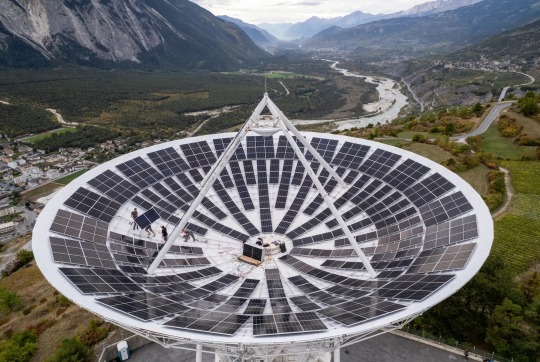
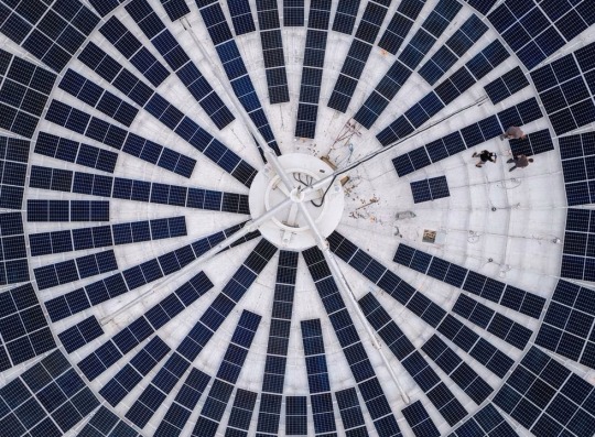
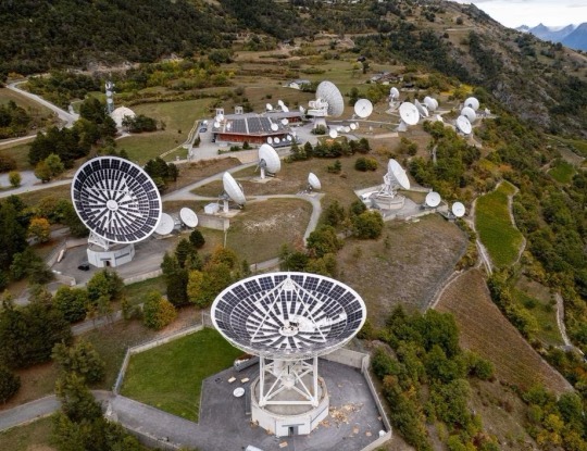
Swiss Energy Services Provider Centralschweizerische Kraftwerke AG (CKW) installs Solar Panels in Satellite Dishes at the Leuk Teleport and Data Centre, Leuk, Switzerland
image credits: Denis Balibouse/Reuters
73 notes
·
View notes
Text
my hypster magazine finally came in the mail lmao and man the special feature talking about how the world is coping without mics is very interesting??? like:
crime as a whole is at an all time high
within ikebukuro, the police are doing fck all about it so the bb have volunteered their services to making the civilians feel safe
ichiro’s been a mediator within more casual disputes, expressing his desire to talk things thru if possible, jiro’s got his whole high school as a neighbourhood watch and saburo’s set up a huge surveillance system to keep watch
in yokohama, the sea port has been particularly targeted and the report says the police and yakuza have teamed up to protect the flow of commerce. katengumi has stepped up to protect the territory and rio is keeping watch via satellite images and drones
in shibuya, dice complains of disruptions in gambling dens and the lack of real gambling has dulled his senses lol. he’s trying to compensate by making his own gambling game lol and he hasn’t been able to pay his phone bill due to lack of funds so he hasn’t been able to talk to ramuda or gentaro
curiously, neither of those two were mentioned in the article, save for dice using the section to try to reach out to them
in shinjuku, the day is desolate and the night scene is busier than ever. doppo’s company has been particularly hit by logistics nightmares as they’re haemorrhaging money due to lost medical equipment. (doppo’s boss has been accusing him of stealing funds and doppo claps back asking what exactly has he been managing currently lol)
shinjuku central hospital has been at full capacity with patients due to the inability to fend off armed criminals. fragrance has seen a significant uptick in patrons
in osaka, businesses have taken a sharp turn towards maliciousness, with scams at an all time high. sasara and rosho advise not to go out at night alone, and rosho, as a teacher, further explains that adults have a duty to protect minors, especially as a person who has been affected by scams in the past. neither sasara nor rosho have heard from rei in a long while, stating dh is on hiatus because of it
in nagoya, petty crimes are up because there seems to be a restlessness amongst them without the mics giving the populace the power to stand out. hitoya himself watched a dude climb up nagoya castle literally for the memes. the court of law has been barren as of late so nobody is being tried for crimes but he believes justice will prevail in due time
kuukou and jyushi have taken up patrolling nagoya in order to persuade others into not doing crimes and all three of them still practice rap battling together
#this is vee speaking#like i highly doubt they’ll put most of this in the drama tracks#so here’s some worldbuilding for y’all when the tracks come out next week(!!!!!!!!!!!!) lol#i love to see how proactive some of these divisions are lol shoutout to bb mtc and bat lol#dice is very funny but i am very concerned he’s out here in this new world without anyway to contact his support group lol??????????????#like not only it’s scary if something happened to him but what if something’s wrong with ramuda and/or gentaro???????????????#and he’s literally too broke to know lol????????????????#the dh section just like………. murdered me because it ends with rosasa wondering if rei’s just somewhere out there drinking without them#aka drinking by himself AND THEYRE………….. THEYRE AIKATAS GODDAMMIT A WHOLE SET DO NOT SEPARATE#i also think it’s neat both bb and bat are focused on trying to resolve with the power of words ::::)#ichiro’s the only one with rap on the entire album and bat’s the only section talking about their rap practices ::::)#lol and somewhat offhandedly hitoya is talking about justice prevailing in front of nagoya castle#and that’s actually nagoya castle’s catchphrase lol i wonder if that’s a very subtle sign for something lol
92 notes
·
View notes
Text
Hey real quick here's how to read weather radar
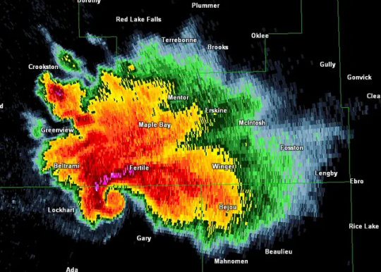
See that swirly bit where it looks like the storm itself is starting to twist as a part of it juts out? That's a hook echo. On your basic radar reflectivity settings on most weather apps that's what you can use to figure out where a tornado is or if one is starting to form. As in, this is one of the things the National Weather Service looks for before issuing a radar indicated tornado warning.
But don't just rely on hook echoes, they may not always form or be clearly visible to the untrained eye. More reliably you can look at velocity radar, which measures wind coming towards and away from a given radar tower.
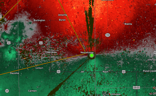
For example, all the red in this image represents wind that is moving away from the radar tower and all the green represents wind that is moving towards it. Ideally, if your wind is moving all in one direction everything on one side should be green and everything on the other should be red. Before we get into what to look for, how do we even get to a velocity radar map?
Well I use a weather app called Radar Omega but you're in luck because the National Weather Service just Has That. It's browser based so using it on your phone gets a little weird so make sure you're not using the mobile version of the site, but basically to get there you go to weather dot gov and type in your location.

For this example we'll be using screenshots for the forecast office in Norman, OK since there's a tornado near Cleo Springs at time of posting. From this page, scroll down until you see links to radar and satellite images.

Click on the radar map
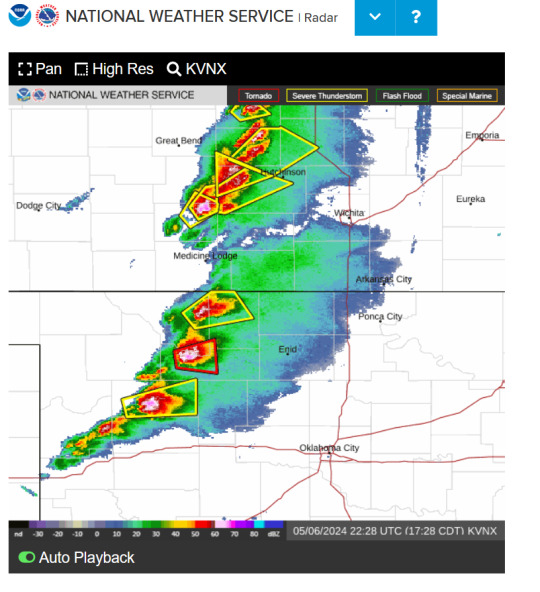
Which will bring you to a screen that looks like this. Click "high res" and that should bring you to radar that looks like this
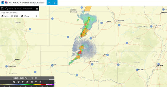
Navigate up to that little bar in the top left
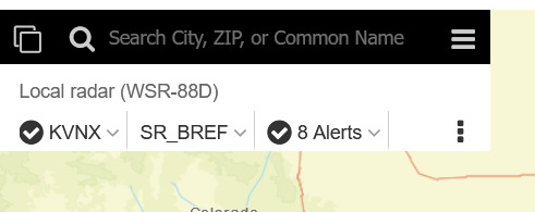
go to the second of the three dropdown menus (yeah I know it's not userfriendly) where it says SR_BREF click on that
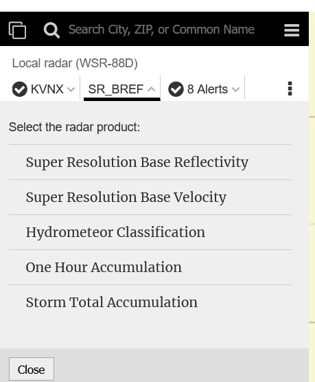
Select Super Resolution Base Velocity
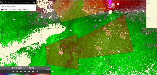
And boom now you have access to base velocity radar images.
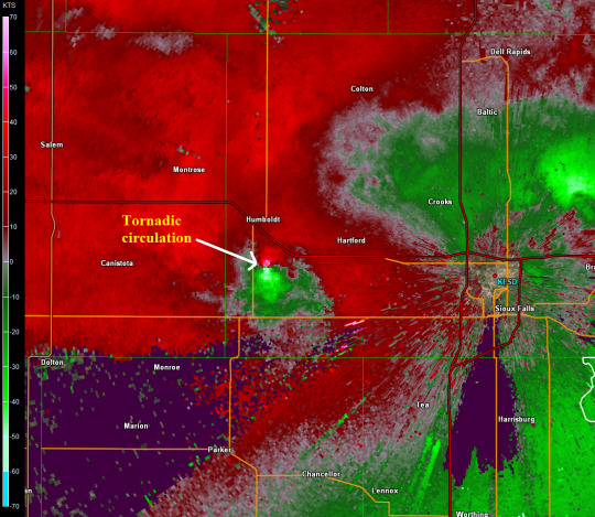
Here's a clearer image of the circulation you're looking for, since the circulation out in OK at time of posting is actually not that visible and currently looks like this:
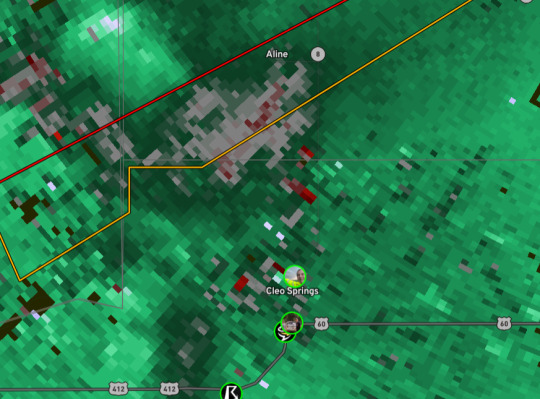
Like you can still see the bits of red and definitely still take shelter but at time of posting it looks like this warned tornado is still trying to form, or may have previously touched down and then lifted and is reforming.
Anyways stay safe y'all and watch How to Read Weather Radar by Watch Chris Chase on YouTube because he explains it better than my "took a meteorology class in community college" ass can
28 notes
·
View notes
Text
The Cyberpunk Genre: From Fiction to Reality
The Real-World Cyberpunk Narrative
In the realm of science fiction, the cyberpunk genre has long captivated audiences with its vision of a high-tech, low-life future. Cyberpunk, a subgenre that emerged in the early 1980s, combines advanced technology with a layer of dystopian elements, often exploring themes of artificial intelligence, cybernetics, corporate hegemony, and social decay. However, what once seemed a distant future is now becoming a striking reflection of our present reality.
The Cyberpunk Reality of Modern Corporations
As we delve into the corporate world, the parallels between cyberpunk narratives and current events become strikingly clear. This article examines the activities of major corporations like Google, Microsoft, Amazon, SpaceX, and OpenAI, highlighting instances that resonate with cyberpunk themes.
"Google: The Digital Panopticon"
Google, with its vast array of services, has created a digital ecosystem that closely resembles the omnipresent corporations in cyberpunk lore. The company's foray into various sectors, from search engines to smart home devices, has raised concerns about privacy invasion and data control, reminiscent of cyberpunk's surveillance-heavy societies.
"Microsoft: The Silicon Overlord"
Microsoft's dominance in the software industry, particularly with its Windows operating system and Office suite, mirrors the cyberpunk trope of a corporation wielding enormous power over everyday technology. The company's expansion into cloud computing and AI further cements its status as a tech giant with a reach that extends into the very fabric of digital life.
"Amazon: The Corporate Colossus"
Amazon's transformation from an online bookstore to a retail and technology behemoth aligns with cyberpunk's portrayal of mega-corporations that transcend traditional industry boundaries. The company's ventures into cloud computing, AI, and even space travel through its Blue Origin subsidiary evoke images of a corporation with almost limitless ambition and resources.
"SpaceX: Architects of the Starbound Future"
SpaceX, under the leadership of Elon Musk, brings to life the cyberpunk fascination with space exploration and privatization. The company's ambitious projects, including the colonization of Mars and satellite internet services, embody the cyberpunk vision of pushing humanity's boundaries, both technologically and geographically.
"OpenAI: The AI Enigma"
OpenAI, known for its groundbreaking work in AI, reflects cyberpunk's preoccupation with the potential and dangers of artificial intelligence. The development of advanced AI models and their applications in various fields raise questions about the future of human-AI interaction, a central theme in many cyberpunk narratives.
Industrial Espionage: A Cyberpunk Reality
The world of industrial espionage, a staple in cyberpunk plots, is no stranger to these tech giants. The competitive nature of the technology industry, driven by the race for innovation and market dominance, has led to numerous instances of data breaches, intellectual property theft, and corporate spying. These incidents underscore the darker aspects of the corporate world, mirroring the intrigue and deception often found in cyberpunk stories.
Cyberpunk Tropes in the Modern World
Several broad tropes characteristic of the cyberpunk genre are increasingly relevant today:
Technological Advancements vs. Societal Decay: The stark contrast between cutting-edge technology and societal challenges, such as income inequality and privacy concerns, is a recurring theme in both cyberpunk fiction and the modern world.
Corporate Power and Influence: The immense power wielded by mega-corporations, often at the expense of individual freedoms and government authority, is a reality in both the cyberpunk genre and today's corporate landscape.
Ethical Dilemmas of AI and Cybernetics: The ethical and philosophical questions surrounding artificial intelligence, cybernetics, and human enhancement are as pertinent in real life as they are in cyberpunk narratives.
Conclusion: Cyberpunk as a Now Genre
As we examine these parallels, it becomes evident that cyberpunk is no longer a genre fixated on a near future. The themes, concerns, and narratives central to cyberpunk are increasingly manifesting in our current reality. The once speculative fiction has transformed into a lens through which we can view and understand the complexities and challenges of our high-tech, corporate-dominated world. Cyber is no longer a near future genre. It's a now genre.
- Raz
36 notes
·
View notes
Text
The ballistic missile hit the Rubymar on the evening of February 18. For months, the cargo ship had been shuttling around the Arabian Sea, uneventfully calling at local ports. But now, taking on water in the bottleneck of the Bab-el-Mandeb Strait, its two dozen crew issued an urgent call for help and prepared to abandon ship.
Over the next two weeks—while the crew were ashore—the “ghost ship” took on a life of its own. Carried by currents and pushed along by the wind, the 171-meter-long, 27-meter-wide Rubymar drifted approximately 30 nautical miles north, where it finally sank—becoming the most high-profile wreckage during a months-long barrage of missiles and drones launched by Iranian-backed Houthi rebels in Yemen. The attacks have upended global shipping.
But the Rubymar wasn’t the only casualty. During its final journey, three internet cables laid on the seafloor in the Bab-el-Mandeb Strait were damaged. The drop in connectivity impacted millions of people, from nearby East Africa to thousands of miles away in Vietnam. It’s believed the ship’s trailing anchor may have broken the cables while it drifted. The Rubymar also took 21,000 metric tons of fertilizer to its watery grave—a potential environmental disaster in waiting.
An analysis from WIRED—based on satellite imagery, interviews with maritime experts, and new internet connectivity data showing the cables went offline within minutes of each other—tracks the last movements of the doomed ship. While our analysis cannot definitively show that the anchor caused the damage to the crucial internet cables—that can only be determined by an upcoming repair mission—multiple experts conclude it is the most likely scenario.
The damage to the internet cables comes when the security of subsea infrastructure—including internet cables and energy pipelines—has catapulted up countries’ priorities. Politicians have become increasingly concerned about the critical infrastructure since the start of the Russia-Ukraine war in February 2022 and a subsequent string of potential sabotage, including the Nord Stream pipeline explosions. As Houthi weapons keep hitting ships in the Red Sea region, there are worries the Rubymar may not be the last shipwreck.
The Rubymar’s official trail goes cold on February 18. At 8 pm local time, reports emerged that a ship in the Bab-el-Mandeb Strait, which is also known as the Gate of Tears or the Gate of Grief, had been attacked. Two anti-ship ballistic missiles were fired from “Iranian-backed Houthi terrorist-controlled areas of Yemen,” US Central Command said. Ninety minutes after the warnings arrived, at around 9:30 pm, the Rubymar broadcast its final location using the automatic identification system (AIS), a GPS-like positioning system used to track ships.
As water started pouring into the hull, engine room, and machinery room, the crew’s distress call was answered by the Lobivia—a nearby container ship—and a US-led coalition warship. By 1:57 am on February 19, the crew was reported safe. That afternoon, the 11 Syrians, six Egyptians, three Indians, and four Filipinos who were on board arrived at the Port of Djibouti. “We do not know the coordinates of Rubymar,” Djibouti’s port authority posted on X.
Satellite images picked up the Rubymar, its path illuminated by an oil slick, two days later, on February 20. Although the crew dropped the ship’s anchor during the rescue, the ship drifted north, further up the strait in the direction of the Red Sea.
For three days, satellite photos show, the vessel largely stayed in place thanks to low winds and weak currents. Then, on February 22, satellite images show peculiar circular wave patterns hitting the ship, as seen in the image below. One former naval intelligence analyst familiar with the images, who asked not to be named for safety reasons, says this could be a sign the anchor may have come loose. One image, they say, appears to show an unidentified object, which could be a small boat, nearby.
Both the wind and currents picked up on February 23, when the ship began drifting for a second time, says Robert Parkington, an intelligence analyst with geospatial analysis firm Geollect. “As wind increases, as current increases, that chance for movement gets so much higher,” says Parkington, who monitored the Rubymar’s movements with data from satellite technology firm Spire Global. “Even a small breeze can have an impact on where the vessel’s moving.”
More than 550 internet cables run along the ocean floors and connect the world. They link continents and economies, beaming everything from Zoom calls to financial transactions every millisecond. Twelve of the cables run through the Bab-el-Mandeb Strait, says Alan Mauldin, research director at telecom research firm TeleGeography. “These cables vary massively in their age, also in their capacities,” Mauldin explains. The region is a crucial, but vulnerable, choke point.
While the Rubymar was drifting, three cables were damaged: the Seacom/Tata cable, a 15,000-kilometer-long wire running the length of East Africa and also connecting it to India; the Asia Africa Europe-1 (AAE-1), which snakes 25,000 kilometers and links Europe to East Asia; and the Europe India Gateway (EIG), made of 15,000 kilometers of cable and joining India with the United Kingdom.
The Seacom cable went down at 9:46 am on February 24, according to new analysis shared exclusively with WIRED by Doug Madory, director of internet analysis at the web monitoring firm Kentik. Five minutes later, at around 9:51 am, the AAE-1 cable dropped offline. Madory says the third damaged cable, EIG, was already mostly offline following a separate fault elsewhere. A telecom industry notice seen by WIRED confirms the three faults and says this was the EIG’s second. The notice says the damage is located around 30 kilometers away from where the cables land in Djibouti and are at depths of around 150 meters.
To determine when the cables lost connectivity, Madory examined internet traffic and routing data from multiple networks. For instance, a network linked to Equity Bank Tanzania, the analysis shows, lost connectivity from the Seacom cable; moments later, it was impacted by the AAE-1 damage. The two clusters of outages impacted countries in East Africa, including Tanzania, Kenya, Uganda, and Mozambique, Madory says. But they also had an impact thousands of miles away in Vietnam, Thailand, and Singapore. “The loss of these submarine cables disrupted internet service for millions of people,” he says. “While service providers in the affected countries have shifted to using the remaining cables, there exists a loss of overall capacity.” The analysis matches when the Seacom cable went offline, says Prenesh Padayachee, the company’s chief digital officer. Both AAE and EIG cables are owned by consortiums of companies, which did not respond to requests for comment.
The telecom industry builds backups into its systems to account for disruptions—and the approach mostly works. When one cable goes offline, traffic is sent via other routes. “Connectivity just went away,” says Thomas King, the chief technology officer of German-based internet exchange DE-CIX, which used the AAE-1 cables. “The issue was detected automatically. Rerouting happens also automatically,” King says. Other firms sent data on different paths around the world.
In the days after damage to the cables first emerged, one unconfirmed press report claimed Houthi rebels could have sabotaged the cables. There has been no public evidence to support this. Farzin Nadimi, a senior fellow at the Washington Institute think tank who has been monitoring the region, says it is most likely that the Rubymar damaged the cables, but Houthi sabotage should not be entirely ruled out, as “highly trained” divers could reach the cables’ depths. Telecom firms have reported fears about Houthi damage to cables, while Houthi spokespeople have repeatedly denied responsibility for the disruptions.
“We don’t even know if the cable is fully broken yet,” Padayachee says. “All we know is that the cable is damaged to a level where we’ve lost comms.” It could have been cut, or even dragged along the seabed and bent so light signals cannot pass through the cable, he says.
Many in the marine and cable industry have turned toward the Rubymar’s drift as the likely cause for the outage. Padayachee says it is the most “plausible” scenario given the ship’s predicted drifting speed. “If you work out the distance between the two cables that roughly relates to the same sort of timeframe as to when one cable will be affected to when the other cable will be affected,” the timing makes sense, he says, adding that the cables are 700 to 1,000 meters apart.
Anchor damage, alongside earthquakes and landslides, is one of the most common ways subsea internet cables are disrupted. For instance, multiple cables in the Red Sea region were damaged by a ship dragging its anchor in 2012. There are also several types of anchor, explain William Coombs and Michael Brown, professors at Durham University and the University of Dundee, respectively, who are researching the dynamics of anchors and how they can damage underwater cables. Some anchors sit on the seabed while others dig into the ground, they say. “If the soil type is not right, and the cable has quite shallow burial or it is on the seabed, you are going to catch it if your anchor starts to drag,” Brown says.
“Considering the timings of when outages were reported, considering the rough location of where those cables are known to be, and considering where we believe to be the location of the Rubymar, I would say that there is a likely possibility that the anchor did cause the damage,” says Parkington of Geollect.
The Rubymar finally sank on March 2. Videos reportedly taken inside the ship, gathered by Saudi state-owned news organization Al Arabiya English, show water gushing into the ship after the missile strike. As the Rubymar took on more water and partially submerged, experts say, its drifting likely slowed and eventually brought it to a complete stop.
While the ship has finished its journey, the three internet cables will remain offline for some time. Padayachee, from Seacom, says that the Yemeni government is likely to approve permits for the company’s repair plans in the next couple of weeks, with repairs to all three damaged cables possibly starting later in April.
Padayachee says that additional security measures are being put in place for the operation, but the repair work itself should be relatively straightforward. The repairs are taking place in water only a couple of hundred meters deep—shallow compared to other cases where cables are more than a mile deep. When the cables are pulled out of the water by the repair crew, it should be possible to say whether the cuts were caused by the anchor or deliberately.
The Rubymar presents one potential final challenge: Padayachee says the location of the cable damage is believed to be around one or two miles away from where the ship sank. “It doesn’t look like it will affect anything in the repair operation,” he says. “It could change by the time they get there: The vessel may have moved or, in fact, the vessel may have broken up and parts of it moved around.” The US Central Command has said the Rubymar also presents a “subsurface impact risk to other ships.”
The Houthi’s missile launches, meanwhile, don’t look like they will stop any time soon. Other ships have been damaged; lives have been lost, and those factors will impact repairs. “It's not something you usually see: trying to have a cable ship into those waters, recover the cable, make a repair, and then be able to return to port. It's a long process. It’s risky,” says Mauldin, from TeleGeography. The risk, for other internet cables, is a repeat of the Rubymar. “It is not out of the question,” Madory concludes in his analysis, “that we could have another vessel, struck by a missile, inadvertently cut another submarine cable.”
16 notes
·
View notes
Text

👆Satellite image showing a before and after of the Sinai area (Egypt) with the land cleared out
Updates
• 87 Palestinians killed, 104 injured in Gaza in past 24 hours
• Israeli air raids over Nuseirat camp (central Gaza) killed 12 incl. 7 kids
🇪🇬 Washington Post: Egypt is creating an area in Sinai (borders Gaza) to hold displaced Palestinians, w/ footage showing bulldozers clearing the area (👆see image above). Egypt’s been refusing any displacement of Palestinians into its territory, threatening Israel to suspend their peace treaty. This doesn’t mean Egypt accepted Israel’s plan, but may be planning for the “worst case scenario”
🇮🇪 Ireland pledges $21.5M to UNRWA; but as major Western donors cut aid, UNRWA will need to halt its services for the 2+ million Palestinian refugees in Jordan & Lebanon by March
• No aid trucks w/ essential goods has passed through Egypt’s Rafah crossing since Feb 4, while there’ve been deliberate delays at Israel’s Karem Abu Salem crossing
• West Bank: Israeli forces abducted 20+ Palestinians overnight, accompanied by severe beatings & abuse
#Palestine#Gaza#Gaza strip#rafah#free palestine 🇵🇸#free palestine#i stand with palestine 🇵🇸#israel is a genocidal state#israel is committing genocide#jews for palestine#free gaza 🇵🇸#israel is a terrorist state#gaza genocide#palestine will be free#news on gaza#israelis are terrorists#israel is a war criminal#israel is an apartheid state#israel is evil#fuck israel#boycott israel#israhell#isnotreal#gazaunderfire#🇵🇸#from the river to the sea 🇵🇸#filistin 🇵🇸#فلسطين 🇵🇸#stand with gaza#free gaza
36 notes
·
View notes
Last Seen Blogs

heartonmytrigger
... Aɴᴅ I'ᴍ Yᴏᴜʀ Lɪᴏɴʜᴇᴀʀᴛ.

heartofmorioh
and the four right chords could make me cry

nectcr
soshy


yvetteelliott1-blog
vlogging camera under 200