#Spatial Data
Explore tagged Tumblr posts
Visit Tumblr Blog
Explore Tumblr blogs with no restrictions, modern design and the best experience.
Last Seen Tumblr Blogs


Fun Fact
Average visit duration of Tumblr.com is 10 mins and 25 secs.
Text
Geospatial Analytics Revolution: Transforming Urban Planning, Transportation, and Defense (2025-2030)
Posted on 22nd May, 2025 by Rene Parekh: Author of Mapping Tomorrow The Dawn of a New Geospatial Era Have you ever wondered how your food delivery app knows exactly when your meal will arrive? Or how city planners determine where to place new public transport routes? Or perhaps how climate scientists predict the impact of rising sea levels on coastal cities with pinpoint accuracy? The answer…
#blockchain#defense#digital twins#geospatial analytics#gis#location intelligence#market growth#remote sensing#smart cities#spatial AI#spatial data#transportatiom#urban planning
0 notes
Text
🧰 Publicly available data
Hunting for spatial data comes naturally now. There seems to be less and less opportunity for doubts when we could attach a pair of coordinates to some places.
For work and hobby, hunting for data take almost half of the usable hours I set aside to execute certain objectives; if not 100%. Although the internet is a vast plain of data, not all of them are usable. The democratization of data is a subject that is to translucent to discuss but to solid to argue with. Thus, with differing opinions, we get different versions of them online. Here are some of the interesting data platforms I manage to scour based on their thematic subject
🌳 Nature and Environment
Delta at Risk - Profiling Risk and Sustainability of Coastal Deltas of the World. I found this while lamenting on how people love asking for data addition into their maps at the eleventh hour. I find their confidence in my skills quite misleading but flattering nonetheless. But it does not make it any less troublesome.
Protected Planet - Discover the world's protected and conserved areas. This platform includes not just data of protected areas, but also other effective area-based conservation measures like ICCAs IUCN listing and as the website claims, it is updated regular via submissions from agencies. So far, I found this platform to be the most convenient since it rounds up all possible conservation-based themes which also includes World Heritage Sites.
Global Forest Change (2000-2020) - The global forest extent change since 2000 to the current year or lovingly referred to as the Hansen data by most forestry RS specialist. This data is updated annually and to be honest, the platforms are literally everywhere. But this platform is legitimate under Earth Engine Apps and you can refer to Google Earth Engine for future data updates to ease your search.
👩⚖️ Administrative Data
GADM - Map and spatial data for all countries and their sub-divisions.
🏦 Built-environment Data
OpenStreet Map - This database is the most amazing feat of tech-aware crowdsourcing. A little more than 2 decades ago, some 'experienced' gate-keeping professionals would have refuted its legitimacy within an inch of their lives but OSM has proven that time prevails when it comes to bringing the accessibility and network data into practical use. I am not that adept with downloading from this website so I go directly to a more manual data download. My favorite is the Geofabrik Download but you can also try Planet OSM.
🎮 Other Cool Data
OpenCell ID - Open database platform of global cell towers. Cleaning the data is a nightmare but I think it is just me. I have little patience for cerebral stuff.
So, those are some of the data I managed to dig for personal projects. Hope it helps you guys too!
0 notes
Text
ok im back to hating everything. My prof really did NOT do a good job this semester I feel completely unprepared and… I’m aware that what I’m trying to do is so much more complex than what we covered in class but normally I don’t have problems to scale things up like this but I think I severely underestimated the complexity of what I’m trying to model. Lol. god I’m so scared bc a huge part of my research hinges on me figuring this out and I have NO ONE I can ask bc no one works with QGIS on this scale so help me fucking g-d lmaoooo 😭
#I’ll be alright I’ll be ok#I’m just venting#I do know people who work with it but they’re acquaintances and it’ll be weird if I ask for help out of the blue#I WILL ask them but not for this assignment cos it’s due on Wednesday 😂#it’s just a little trial run so I’m ok bc I think I have enough data for that#I’m just gonna do some raster analysis tmrrw bc I’m good at that#and then hopefully he won’t notice that I have no fucking clue how to interpret the spatial lag model lololol#I just don’t fucking understand what my output is tbh#like. 😭 too many variables and they’re so weirdly spatially distributed but I don’t understand where that comes from bc#they should be clustered bc I RECORDED them as clusters myself#is it bc the stupid model doesn’t understand that there’s 5 clusters? and it treats it like they are one giant cluster?#I don’t know! and neither does the fucking internet apparently! 😂#UAGGHHHH ok time to go to bed#shut up Sam
2 notes
·
View notes
Note
must have missed the hot ta saga update where you got laid. congrats!!
omg yea the whole thing is still chronicled in the "ta saga" tag but i think i only mentioned the first occasion:

but yea lol we fucked 3 different times, first at my house, then in his car on campus during lunch break of a summer statistics workshop (which was so hot tbh), then at his house. then we kinda just didnt talk much + he got sick + busy semester
...but honestly time has just passed and ive gotten kinda bored/over it with him lol. we met up for lunch recently and i wasnt really feeling it. maybe its cuz im on meds now LOL. who knows, i havent fully written it off
#thots et al#ta saga#physically hes so hot its insane but its getting to the point where i dont rly vibe with him as much personally sooo im bored#i think its also cuz like he seems to see me as someone he only reaches out to when he wants to fuck which is fair cuz like i said#we dont have much in common tbh beyond data science (and even then he doesnt know shit abt spatial data)#but at the end of the day even tho im aro im still demi!!! i still need to like ppl to wanna fuck em!!#is it really FWB if we aren't even really friends?? u know??#idk!!!#thanks for the anon hehe this is fun
3 notes
·
View notes
Text
my early childhood education class is really driving home the developmental in developmental disability.... like i knew thats what adhd is classified as but they just keep dropping skill after skill that are standard for Small Children that i do not have D:
#attention span. is of course the one that is most noted but even like#theres that one adhd sway thing and i was like huh i do that guess theres another data point. not a big deal though it doesnt cause any iss#es#right. well. apparently one of the skills youre supposed to get is spatial awareness. and it specifically mentioned going around things#which technically ! i do but also sometimes. quite often even#i do not manage fully around. meanwhile its expected for Small Children to get able to do that. huh what HUH#beeep#like again not getting fully around isnt a Big deal i just get caught on doors and then uncatch myself its not Disabling like other aspects#and if i hadnt seen the youtube (the youtube referencing a study not just a youtube)#i wouldve kept on assuming its just a itty bitty side effect of weird eye#but like......... man. in nearly every area i was like wow i suck at this one wow i suck at this one w#its a good thing im an adult algebra is much easier than counting to one hundred . u can write it down and when u lose your place u just#look at the paper#although i havent gotten algebra in a while i miss it............ but i could go do algebra. if i had time. and thats what is nice#anywayyyyyyy ahaha
3 notes
·
View notes
Text
location intelligence data
Advintek Geoscience is a leading provider of Location Intelligence solutions in Singapore and across ASEAN, delivering advanced geospatial analytics powered by MapInfo Pro and Precisely’s Spectrum Suite facebook.com+15geosciences.advintek.com.sg+15linkedin.com+15. Leveraging powerful mapping, spatial analysis, and real‑time data integration, they help businesses and government agencies uncover hidden patterns, optimize operations, and make smarter decisions .
From supply chain enhancements and site selection to public safety, telecom planning, and smart‑city deployment, Advintek’s scalable, secure platform enables cost optimization, predictive insights, and improved customer targeting geosciences.advintek.com.sg+1sg.linkedin.com+1. Their seamless integration with existing CRM, GIS, and BI systems ensures smooth adoption, while real‑time dashboards and geofencing offer actionable insights on the go geosciences.advintek.com.sg.
Trusted across diverse sectors—including energy, utilities, urban planning, and emergency response—Advintek’s Location Intelligence empowers clients to transform spatial data into transformative business outcomes facebook.com+15
#Location Intelligence Singapore#Geospatial Analytics ASEAN#MapInfo Pro Solutions#Spectrum Spatial Tools#Spatial Data Visualization#Real‑Time Geospatial Insights#location intelligence data#location based intelligence#location intelligence esri
0 notes
Text
How GIS Helps in Identifying High-Growth Areas for Real Estate Investment
In an ever-changing real estate landscape, identifying areas poised for rapid development isn't just a competitive advantage—it's a necessity. Traditional methods of forecasting growth often fall short in addressing the complex interplays of infrastructure, demographics, and access to essential amenities. That's where Geographic Information Systems (GIS) step in as a transformative force.
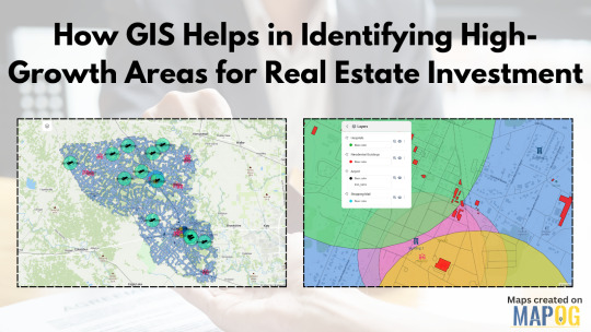
GIS as the Eye Behind Data-Driven Real Estate
GIS technology allows users to visualize and analyze layers of geographic and statistical data all in one view. From traffic congestion and transportation routes to proximity to hospitals, schools, malls, and airports—all of this can be layered spatially to make more informed investment decisions. For real estate developers, this is more than just data; it's a dynamic decision-making tool.
By using GIS, stakeholders can map out locations with strategic access to critical infrastructure. Suppose you're analyzing a city for future residential projects. You could create buffers around public transit lines, shopping centers, and educational institutions to isolate high-potential zones. These buffers offer clarity where raw data often fails to paint the full picture.
Solving the Real Estate Guesswork
One of the biggest pain points in real estate is uncertainty: will a particular neighborhood rise in value? Will upcoming infrastructure really influence demand? GIS helps answer those questions by showing not just what exists, but how it interacts across space and time. For instance, you could track development permits over time or visualize environmental constraints like flood zones or green cover. These insights are crucial for mitigating risk and spotting overlooked opportunities.
Industries like urban planning, government housing departments, logistics, and commercial development firms increasingly rely on GIS to plan smarter. Even small-scale investors are catching on, thanks to platforms that simplify GIS applications into more user-friendly formats.
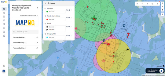
One Platform, Many Possibilities
Some mapping tools now let you not only import transportation and amenities data but also define your area of interest, set proximity buffers, and drop pins for future projects. You can even share interactive maps with teams or stakeholders. One such example is a GIS platform like MAPOG, which simplifies the entire GIS workflow from analysis to visualization without needing deep technical skills.
Whether you're evaluating urban corridors for commercial hubs or scoping out suburban areas for housing, GIS offers the clarity you need. Try exploring platforms like MAPOG if you're looking for a seamless way to start.
#realestateinvestment#gis#mapog#gismapping#smartcities#urban planning#urban growth#mapping#data visualization#spatial analysis#propertydevelopment
0 notes
Text

Advance your career with IGMPI’s industry-oriented PG Diploma in Geoinformatics. Learn GIS, remote sensing, spatial data analysis & more. Enroll online today!
Enroll in the Post Graduate Diploma in Geoinformatics offered by IGMPI – a government-recognized institute. This distance learning course provides in-depth knowledge of GIS, remote sensing, spatial data analysis, and practical tools used in geosciences and urban planning. Ideal for professionals in geography, environmental science, agriculture, and infrastructure sectors.
#Geoinformatics course India#PG Diploma in Geoinformatics#GIS course online#IGMPI Geoinformatics program#remote sensing training#spatial data analysis course#GIS distance learning#Geoinformatics certification India#GIS and mapping course#online Geoinformatics diploma
0 notes
Text
Harnessing the Power of GIS Data for SEO: Transforming Digital Marketing Strategy
Harnessing the Power of GIS Data for SEO: Transforming Digital Marketing Strategy
Having recently completed comprehensive training in Geospatial Data Collection, Analysis & Interpretation using GIS Technology, I’ve discovered fascinating intersections between my established background in SEO and digital marketing and the powerful capabilities of geospatial analysis. This educational journey, covering everything from fundamental GIS concepts to advanced geospatial analysis and…
#AI-Geospatial#Business-Intelligence#Digital-Marketing-Strategy#Geospatial-Analytics#GIS-Data-Analysis#GIS-Marketing#Local-SEO-Optimization#Location-Intelligence#Marketing-Technology#Spatial-SEO
0 notes
Text
Study indicates lower rates of death from Alzheimer's Disease among Taxi and Ambulance Drivers
Study indicates lower rates of death from Alzheimer's Disease among Taxi and Ambulance Drivers @neosciencehub #Sciencenews #healthcare #AlzheimersDisease #neosciencehub #Dementia #featured
According to a recent study, occupations requiring a lot of spatial processing, like navigating to a hospital or figuring out a taxi route, may have a reduced death risk from Alzheimer’s disease. Mass General Brigham researchers looked into this possibility by assessing the likelihood of Alzheimer’s disease death across 443 professions using national data on the occupations of deceased…
#Alzheimer’s disease#cognitive spatial maps#featured#National Vital Statistics System#sciencenews#socio-demographic data
0 notes
Text
Exploring Local Communities Through Carmel Zip Codes

Credit: Image by Republica | Pixabay
An Overview of Carmel Zip Codes and What They Offer
Imagine moving to a new city or planning a trip to an unfamiliar territory; without clear guidance, you may waste time searching for activities that match your interests. Well, the unsung heroes of geographical organization are zip codes! If you wish to explore the coastal area of the Monterey Peninsula and the beautiful Carmel-by-the-Sea, break it down into manageable parts to find what you're looking for with ease and precision. Here's an in-depth look at notable Carmel zip codes and what they offer.
What Are The Carmel Zip Codes?
Carmel Village itself and its surrounding areas are predominantly within the 93921 zip code. The more remote parts, such as Carmel Highlands and Carmel Valley, are zoned under 93923 and 93924 zip codes, depending on the specific area. These Carmel zip codes mark neighborhoods and districts and showcase unique lifestyles and attractions.
Why Use Carmel Zip Codes When Exploring?
Carmel’s zip codes help visitors and residents explore the area, understand its geography, and discover what each part offers.
Pinpoint Diverse Neighborhoods Carmel zip codes represent a unique aspect of living, from the bustling charm of downtown to the quiet luxury of cliffside communities or the sun-drenched appeal of inland areas.
Tailor Experiences to Preferences Carmel zip codes can guide you to areas with attractions that match your interests. Love the beach? Focus on 93921. Prefer vineyards and open spaces? Head to 93924.
Ease Real Estate Searches Homebuyers can use Carmel zip codes to target specific lifestyles, property types, and price ranges. These codes help streamline the search for their dream home, whether they seek a coastal cottage or a sprawling valley estate.
Discover Hidden Gems Carmel zip codes often include lesser-known spots that might not appear in general guides. For instance, 93922 offers serene hiking trails and stunning ocean views less heavily marketed than downtown Carmel's attractions.
Simplify Navigation Exploring the Carmel region using zip codes makes it easier to navigate, whether you're planning a trip or relocating.
Get To Know Carmel Zip Codes
93921: Carmel-by-the-Sea’s Storybook Charm
The 93921 Carmel zip code is inseparable from charming downtown and the surrounding neighborhoods. This area offers charming scenery of fairy-tale cottages, small-styled shops, and beautiful artistic galleries. Roads are easy to walk, and the neighborhood environment creates a village vibe, making it suitable for people who have retired, families, and working people.
Homes in this area range from small bungalows to multimillion-dollar estates. Dining options are abundant. Parking and home prices can be challenging, but the unique charm outweighs the drawbacks for many.
93923: Coastal Elegance of Carmel Highlands
93923 zip code covers Carmel Highlands, which is located to the south of Carmel-by-the-Sea. This area is affluent, with cliff homes and villas with breathtaking vistas of the Pacific Ocean from their balconies. Some rank among the most costly in the region and cater to luxury buyers.
Carmel Highlands appeals to those seeking tranquility and high-end living. The atmosphere is rural, the location is relatively secluded but it is only a few minutes’ drive from Carmel town proper. Places of interest include Point Lobos State Natural Reserve which offers trails as well as wildlife viewing opportunities.
93924: Carmel Valley’s Vineyards
Carmel Valley is famous for its sunny weather and wine-country vibes. Bernardus and Holman Ranch wineries are among the many that make this area a wine-lover destination. In addition to vineyards, golf courses, and equestrian properties define the area.
Homes in 93924 often have large lots, perfect for anyone seeking a quiet retreat. They are less expensive than coastal Carmel but require a longer commute to the beach and shopping centers.
93920: Big Sur’s Rugged Beauty
The 93920 zip code includes Big Sur, which is famed for its stunning topography along the edges of the ocean. Due to its aforesaid features, this region is perfect for those who are in search of solitude and stunning landscapes. Many houses rest at the cliff edges affording extraordinary views of the sea.
Big Sur is a haven for artists, nature enthusiasts, and those who crave privacy. However, living here means limited access to amenities. Residents often travel to Carmel or Monterey to shop and dine.
93940: Monterey’s Urban Convenience
93940 includes Monterey. Though not part of defined Carmel zip codes, it is definitely close. This area is ideal for those who want proximity to downtown Monterey, Cannery Row, and the Monterey Bay Aquarium.
Homes here range from historic Victorians to modern condos, catering to various budgets. The area boasts excellent schools, parks, and family-friendly activities. Monterey’s vibrant cultural scene and stunning bay views make it a desirable destination.
93950: Pacific Grove’s Coastal Retreat
The 93950 zip code covers Pacific Grove, located just north of Carmel. This charming seaside community features historic homes, coastal trails, and a laid-back lifestyle.
The Lovers Point Park and Asilomar State Beach are favorite spots for outdoor activities. Homes here are more affordable than those with Carmel zip codes, attracting families, retirees, and first-time buyers.
93953: Exclusive Pebble Beach Living
Pebble Beach is an internationally renowned community. This area is synonymous with prestige and is known for its luxury estates and world-class golf courses. Residents enjoy gated privacy, stunning ocean views, and access to the famous 17-mile Drive.
Pebble Beach is perfect for golf enthusiasts and affluent buyers looking for exclusivity. The area’s top-tier schools and peaceful surroundings also attract families. With high property values and HOA fees, living here requires a significant financial commitment. However, for those who can afford it, Pebble Beach offers unparalleled luxury.
93955: Affordable and Accessible Seaside
Seaside is just north of Monterey. This area is one of the more affordable options near Carmel zip code addresses. It is a practical and budget-friendly option for coastal living.
It has a mix of older homes, newer developments, and some apartments. It is close to California State University Monterey Bay and Fort Ord National Monument.
Wrap Up
Carmel’s zip codes offer distinct lifestyles, from rugged beauty to unparalleled luxury. Whether you prioritize affordability, exclusivity, or proximity to nature, the Monterey Peninsula has something for everyone. Understanding what each zip code offers can help you find the perfect fit for your needs.
Visit https://heinrichbrooksher.com/zip-code-map/ to explore the unique neighborhoods defined by Carmel zip codes and find your perfect coastal home today.
Explore the stunning coastal neighborhoods, lifestyles, and attractions with our complete Carmel zip code guide!
#Community Information#Real Estate Blogs#Real Estate#Carmel CA Real Estate#Carmel CA Realtor#Carmel CA Homes#Carmel CA Neighborhoods#Carmel CA Communities#Carmel-by-the-Sea ZIP Code Map#Carmel CA Postal Codes#Monterey County ZIP Code Map#Carmel 93923 Boundary Map#93921 Carmel Downtown Map#California ZIP Code Locator#Carmel Neighborhood Maps#Carmel CA Real Estate Map by ZIP Code#Zip Code Boundaries#Mapping Carmel CA#Carmel CA Demographics#Geographic Information System#County Map#Municipalities#Census Data#Urban Planning#Demographics#Cartography#Spatial Analysis#Geographic Data Visualization#Boundary Mapping
0 notes
Text

Enhancing Gas Pipeline Management with GIS: Key Benefits and Applications
In the energy and utilities sector, gas pipeline management is complex, requiring precision, safety, and a clear strategy for both existing infrastructure and future expansion. Geographic Information Systems (GIS) have revolutionized pipeline management by providing a spatially accurate, data-rich view of assets. From asset management and leak detection to route planning and demand forecasting, GIS is becoming indispensable for gas companies. This blog delves into the ways GIS transforms gas pipeline management, delivering benefits across safety, efficiency, cost-saving, and planning.
#benefits of using gis for gas pipelines#ensuring gas pipeline safety with gis tools#gas network analysis#gas pipeline asset management#gas pipeline gis mapping services#gas pipeline leak detection using gis#gas pipeline management in gis#gas pipeline mapping software#gas pipeline monitoring tools#gas pipeline risk assessment#gis applications in energy sector#gis for gas pipeline monitoring#gis for infrastructure management#gis in oil and gas industry#gis pipeline maintenance software#gis pipeline monitoring system#gis pipeline route planning#gis software for gas pipeline route optimization#victoryofgoodoverevil#gis solutions for pipeline maintenance and monitoring#gis-based pipeline integrity management#pipeline data management#pipeline geographic information systems#pipeline management solutions#remote sensing for gas pipelines#spatial analysis for gas pipelines#spatial data for gas pipelines
0 notes
Text
Map: Close City Amenities in Detroit
A new tool to measure accessibility and walkability in cities is out called Close from Nat Henry. The tool relies on supermarket and libraries data points in order to assess closeness. Oddly the data sources are not listed, so it is tough to measure supermarkets against our annual updated list of grocery stores and the data clearly doesn’t account for Detroit’s trouble with library funding and…
#2024#CityLab#Close#data#Detroit#geography#grocery store#Henry Spatial Analysis#library#map#Nat Henry#supermarket
0 notes
Text
Understanding Hybrid Spaces - Paper presentation at Expanded Animation Conference . Ars Electronica 2024
The new spatiotemporal model shows correlations between location, interactions and human perception. Various dynamic topologies of hybrid spaces can thus be represented and patterns can be better recognized. From the perspective of the media, this model conveys a new understanding of urban space. Understanding Hybrid Spaces – Designing a Spacetime Model to Represent Dynamic Topologies of Hybrid…
#architecture and urban planning#bernhard tschumi#bo lenntorp#Data Visualization#Digital Twins#felix guattari#Gilles Deleuze#hybrid space#Media Theory#Spatial Perception#urban planning#Virtual Reality
0 notes
Text
Mapping Crime Hotspots Using Grids and Heat Bubble Tools
Crime analysis is one of the most critical areas where Geographic Information Systems (GIS) have made a significant impact. With urban areas expanding and public safety being a major concern, law enforcement and municipal authorities are turning to geospatial tools to detect patterns and predict potential crime zones. But what happens when raw crime data is overwhelming or scattered? That’s where grid mapping and visual heat analysis step in—offering clarity, precision, and actionable insights.
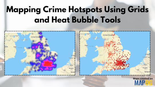
In cities where thousands of crime records accumulate monthly, manual analysis isn't practical. The real challenge lies not just in collecting data but in making sense of it quickly and visually. A platform like MAPOG lets you upload crime data from Excel or CSV files, generate grid overlays to segment zones, and apply heat bubble visualization to highlight areas of concern. It’s an effective and simple way to convert cold statistics into something intuitive and readable.
Why GIS is Crucial in Crime Analysis
GIS doesn’t just plot points on a map; it contextualizes the data. Whether it's tracking burglary incidents across a city or analyzing patterns of assaults in specific neighborhoods, GIS allows users to filter events by time, frequency, and type. Over time, this reveals clusters and trends that can inform preventive strategies. For instance, if a neighborhood shows consistent activity near schools or parks during certain hours, police patrols can be adjusted proactively.
Several industries benefit from this type of spatial intelligence. Public safety agencies rely heavily on it, but so do urban planners, academic researchers, and even insurance companies assessing neighborhood risk profiles. When used in real-time or near real-time, GIS-based crime analysis can influence policy decisions, budget allocations, and community engagement strategies.
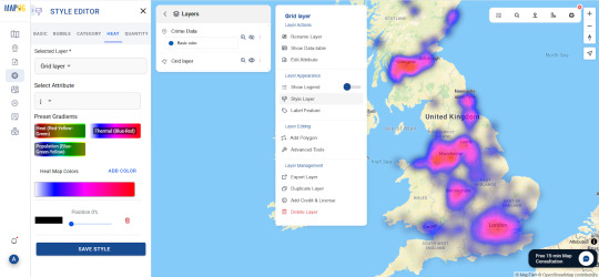
Data-Driven Visualizations: The Power of Grids and Bubbles
Grids simplify large datasets by dividing geographic space into uniform cells. This not only organizes information but also reveals spatial patterns you might miss in traditional pin maps. When layered with heat bubble tools, each cell or hotspot visually reflects the volume or severity of incidents. High-density areas stand out, drawing immediate attention to potential problem zones.
Platforms that offer both grid and heat mapping in one interface save time and reduce errors from switching between tools. By using the preview and share features, users can also collaborate or present their analysis to decision-makers without exporting files or relying on additional software. If you're looking for a solution that combines upload features, grid generation, and heat visualization, it's worth exploring this kind of mapping system. You can try one MAPOG and experiment with your own dataset.
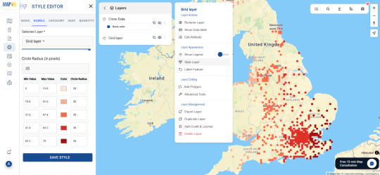
Conclusion
GIS technology is transforming the way we approach public safety, offering clear visual narratives in a sea of raw numbers. Whether you're an analyst, policymaker, or student exploring spatial intelligence, crime hotspot mapping using grids and heat tools provides both insight and foresight. Want to see how this works for your own city or study? Consider testing out a mapping workspace that enables data uploads, grid creations, and interactive visual sharing.
0 notes