#strawberry mountain
Text
Strawberry Mountain Wilderness Loop (3/3)
So, this hike out to the car from Strawberry Lake was maybe the shortest day I've ever had on a backpacking trip, but considering the sheer amount of distance I'd covered in the previous six days, I wasn't disappointed at all to wake up and walk only a mile or so.
I'd wanted to get an early-ish start despite the short distance, only because I still had to drive the six or so hours home from Prairie City before dark; however, it had been surprisingly cold overnight, and so I spent some time in the morning waiting for the sun to clear the rim of the basin before I climbed out of my tent for good.
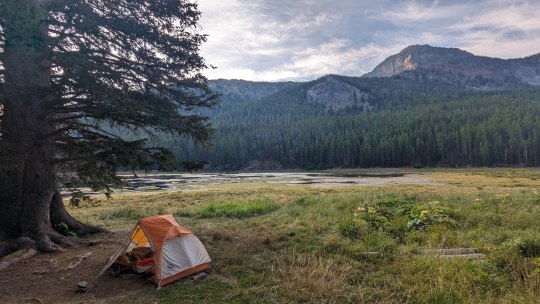
In the morning light, Strawberry Lake was gorgeous. And yes, there were more lake reflections.
On the hike out, I circled around to the west side of the lake instead of the east side that I'd spent so much time "exploring" the previous night. This gave me some further, final great views before I got on the trail and took it north to the car for a mile.

Having never completed a solo backpacking trip of this length before, I was already feeling like I'd accomplished something momentous, but then just before reaching the parking lot, I looked up at the cliff hanging high above the trail and saw...a mountain goat.
Of course, I have no way of knowing that this was in fact my goat "friend" seeing me off before I left him to his own goat-devices in his wilderness, but I immediately decided to believe that that's what happened.
I couldn't get a good picture of him, but you might be able to make him out in the center-distance...
Finally, for the sake of thematic consistency, I got a bit cleaned up at the car, changed into some clean(er) and comfortable clothes for driving, and then proceeded to have another celebratory muffin along another creek before finally pointing the car toward home.

In the end, Strava tells me this is what happened:
Day 1: East Eagle to Crater Lake - 7.25 miles, 3,187 feet gain
Day 2: Crater Lake to Mirror Lake - 18.25 miles, 4,247 feet gain
Day 3: Mirror Lake to Hidden Lake - 11.75 miles, 2,850 feet gain
Day 4: Hidden Lake to East Eagle - 9 miles, ~0 feet gain
Day 5: Strawberry TH to Little Slide Lake - 5 miles, 1,800 feet gain
Day 6: Little Slide to Strawberry Lake - 17.5 miles, 3,000 feet gain
Day 7: Strawberry Lake to Strawberry TH - 2 miles, 200 feet gain
7-Day Total: 70.75 miles, 15,285 feet gain
Yikes.
#camping#hiking#writing#traveling#backpacking#mountains#eastern oregon#strawberry wilderness#photos#strawberry mountain
5 notes
·
View notes
Text


Strawberry Mountain, 9,038 feet up and highpoint for the range. 16 July 2022.
1 note
·
View note
Text
#harsh augmented reality#strawberry mountain#alternative/indie#alternative#indie#spotify#new music#song recommendation#graveey#music#graveey recommends songs
0 notes
Audio
Harsh Augmented Reality - Strawberry Mountain
1 note
·
View note
Text
"I wish I could tell you things are gonna be okay
But we know it's not the same
I want to tell you that I know that you can change
But you still drive your friends away
You've got to live with the decisions that you've made
Sometimes burned bridges just can't be remade
But be thankful that it wasn't too late
Your wake up call has come today"
0 notes
Text
youtube
1 note
·
View note
Text
Phantoms the type of kid to eat a whole tub of strawberries and then cry to Swiss because he’s got stomach pains
But he doesn’t learn his lesson
#ghost band#the band ghost#ghost ghouls#ghost bc#ghost#nameless ghost#nameless ghouls#ghost headcanons#ghoul headcannon#damagedghoulette#ghoul hcs#ghost hc#shitghosting#phantom ghost#phantom ghoul#swiss ghoul#swiss ghost#I’ve just eaten a whole tub of strawberries myself and that’s the healthiest I’ll ever be#mountain is the best
209 notes
·
View notes
Text
together let's go to the mountain ⛰️
#twst#twisted wonderland#treyjade#trey clover#jade leech#fanart#i don't know why there are less people in english fandom that ships them together#i am going down for them so hard just by being fed by all the fanarts from the japanese fandom#i love how they can support each others on the things they like#trey like cooking jade like eating#jade like mountaining trey can absolutely go along with him & match his pace with his physical fitness#plants? terrariums? mushroom? strawberries? no problem they both like to hang around in the botanical garden#trey giving mean eyes and show his meaner side oh jade would go absolutely ballistic#i just love them both together so much 🎶#they are my comfort ship#and how jade is the baby girl but he is taller than trey oh absolutely adorable
501 notes
·
View notes
Text

Time to climb ! 🏔️✨🍓
#celeste#celeste game#madeline celeste#strawberry celeste#strawberry#strawberries#flying strawberry#maddy thorson#celeste mountain#video game#gaming#platform
88 notes
·
View notes
Text


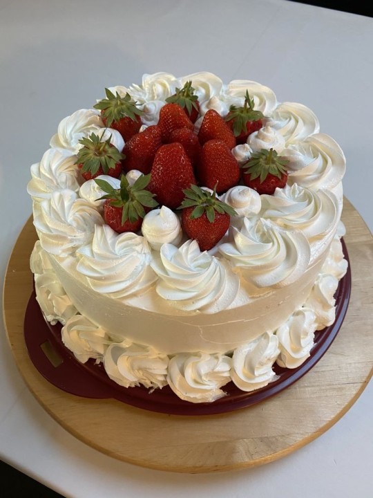
#cake#food#strawberry#strawberies#cakes#pretty#places#aesthetic#cottagecore#nature#moodboard#photography#scenery#meadowcore#art nature#cottage aesthetic#field#inspo#icons#mountains#mountain#art#art aesthetic#sky#sunrise#beautiful#scenecore#cloudy#view#moon
215 notes
·
View notes
Text
Strawberry Mountain Wilderness Loop (2/3)
The goat did not come back overnight. When I woke up in the morning, I was alone. I didn't know this at the time, but I was done with intense animal encounters on this trip. However, I did have one more long day of distance/elevation gain between me and Strawberry Lake, so I made sure to get an early start.
Before heading out, I scanned the rock walls encircling Little Slide Lake one last time by the morning light, but saw no sign of the goat. From past observations, I knew that goats tended to climb up high at night, so I guessed he was somewhere beyond the rim of the cliff; ironically, where I was headed to that morning, albeit by a different route. The couple and their retriever camped out along Slide Lake were still asleep as I passed by through dewy, knee-high grass. I managed to not wake up the dog, or, more likely, he heard me and decided to ignore me.
After a brief descent, I hooked on to the evocatively-named Skyline Trail and headed south. I was excited by the prospect of taking what looked like a fun, steep traverse below the 8,300 foot Rabbit Ears, and it was great. It was one of those traverses where the scree and the slope combine to make the trail almost invisible, and where the footing is straightforward but the margin of error is small. In short, the sort of thing where you can feel like you're doing something really dangerous without ever actually being in that much danger of falling.

Once I'd crossed the traverse, I turned around and took a photo of the way back, which definitely made it look cooler than it was. If you squint, you can make out the trail.

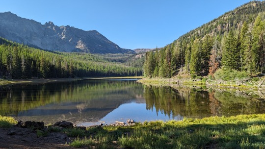
With the traverse behind me, I climbed up a bit to a point south of and just below the Rabbit Ears and, with reception for the first time since my hotel stay, I briefly called Lindsey to check in. Then I circled around the point and got my first view of my next destination: High Lake. It was...burnt.

Fortunately, it was windy enough and early enough in the day that the long, winding descent down into the basin wasn't too hot. I hadn't covered a ton of distance by the time I reached the lake, but I'd passed through some tough terrain and so I had to stop and refill a water bottle. While I was waiting for the solution to mix, I wandered a bit around the shore of the lake and was happy to find it was absolutely covered in mountain goat tracks. I didn't see any goats anywhere near (not for lack of looking), but they clearly dig High Lake, at least when there aren't people around.
From High Lake, the next step was to climb back out of the basin to the west and link up briefly with the road that terminates at High Lake Rim Trailhead. This was a hot but relatively short climb, and when I topped out at the trailhead, I immediately bumped into two heavily armed hunters and their friend, who was being noisily sick in the bushes. I did not take any pictures of this part.
After making sure the sick man was going to be alright, I chatted with the other two men for a few minutes. They were friendly, and I was friendly, but it was funny how clearly they were confused by my desire to simply hike through the woods for days on end with no "real" goal in mind, likely to the same degree that I was confused by their need to shoot big animals to death for fun.
I headed north, briefly, on a paved road. It's not the first and likely won't be the last time part of one of my backpacking trips involves walking on asphalt, but it always feels slightly weird.
Before long, I got to the Road's End Trailhead, and proceeded from there along - unexpectedly - a really gently-graded, grown-over double-track for awhile.

It occurred to me partway through this section that maybe "Road's End Trailhead" was the end of a new road, and what I was hiking on now had once been an older road that had been cut off and abandoned because of the wilderness boundary established along the ridge in 1964.
Because I had reception and am a huge nerd, I opened my GaiaGPS app, switched on the 1930 USGS Topo layer, and immediately saw the double-track represented on the map as a road rather than a trail. Pre-Wilderness Act, then, you would have been able to drive a car all the way to the Onion Creek Trail! Trail history is pretty, pretty cool.
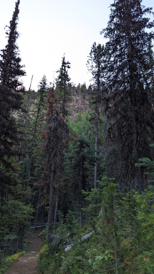
As it was, being 2023, I had to walk the double-track all the way to the Onion Creek Trail instead. But once I got to the intersection, I was rewarded with amazing views of Indian Creek Butte and the surrounding hills to the west, and my first view of the absolute spike of Strawberry Mountain to the north.

My route to the summit seemed pretty straightforward from here.
I followed the surprisingly narrow and loose Onion Creek Trail north to the intersection with the Strawberry Basin Trail, then settled into the shade between two trees and took a good, long break. Technically, I had covered about half the distance I'd planned for the day at this point, but I was feeling worn out and I still "had to" climb a mountain, then descend to Strawberry Lake.
I really enjoyed this little spot, but I don't have a photo of it to share. Oh well.
During the approach to the mountain, it became clear that even though the "official" trail lead around the cone to the east and then ascended to the summit via the north side, there was also at least one human-made scramble trail going up the south face. While this use trail would have been shorter and faster than hiking around the girth of the mountain to climb it from the north, the last decade of my life is absolutely littered with hikes where I took the short, hard route instead of the slightly longer easy route and ended up regretting it. So, taking into consideration the fact that I was already pretty wiped out and that my stomach had started hurting again, I followed the trail around the mountain and then up to the summit.
Considering that this was almost 1,000 more feet of gain above the spot where I'd taken a break, it was actually much easier going than I'd expected, and pretty soon I was finally standing on top of Strawberry Mountain, looking out at the beautiful, blasted wasteland that is eastern Oregon.

I spent an inordinate amount of time on the summit (by my standards, at least...it was probably thirty minutes, total), enjoying the view and watching a murder of crows play around in the air currents, and then it was time to climb back down.
I took the south-facing death-route down. Of course I did. What did you expect?!
It was really steep, but also really fun since I didn't actually break either ankle. There was no actual trail, so I just made one up.

Back at the trail intersection, I availed myself of my break spot a second time, then descended down into the Strawberry Basin, noting as I did the first big patch of (north-facing, dirty) snow I'd seen on the hike thus far. Still some leftovers from last winter hanging on!
This portion of the hike was blessedly downhill the whole way, and passed through some meadows below Strawberry Mountain proper that would have been absolutely full of wildflowers a month or so earlier. As it was, I enjoyed the change back to green (instead of brown) scenery and kept moving.
I took another break at Strawberry Falls, which was surprisingly loud and impressive for this late in the year. Then I continued on, via a brief climb, to Little Strawberry Lake. This was where my already-long day started becoming longer than expected.
Originally, I'd planned to camp at Little Strawberry Lake instead of the bigger, further away Strawberry Lake. I'd wanted to do this to avoid the crowds (like the one I'd seen on my way into the wilderness the day before), and my impression was cemented when I got a glimpse of the big lake during my descent and noticed that it seemed scummy and marshy.
Unfortunately, when I got to Little Strawberry, it was more of the same. While there were a few good camp sites, the entire shore around the lake was essentially one huge tangle of deadfall. The lake's level was very low and the water had a film across the top: not particularly atypical for mountain lakes in the dry part of Oregon this time of year, but also not something I really wanted to have to pull drinking water from if I didn't have to. I wandered a bit further east on a use trail and found a beautiful meadow boxed in by some more cliffs, but the lack of clean, accessible water was still bugging me. I sat down to take a break and eat at one of the camp spots while I thought things over.

By the time I finished my snack, I'd resigned myself to hiking back to Strawberry Falls and then descending to Strawberry Lake proper. I just hoped that the water there would be a little more...drinkable.
Technically, it was only 1.5 more miles, all downhill, to get to the big lake. But, it had been a really long day already, and I was ready to be done. Unfortunately, it wasn't over yet. When I reached the lake from the south, I was presented with a really beautiful, marshy tableau in the fading sunlight, but nowhere to camp or easily access water.

So, I decided to circle the lake and see if I could find a place to stop. Here, though, my tiredness made me stupid, and after hiking about a quarter of the mile-round circumference of the lake, I dropped my pack at a bad-but-available prospective spot and continued on without it. When I finally found a good spot, I had walked completely around to the other side of the lake from my pack. Which meant I had to walk the half-mile back to get it, and then the half-mile back again with it on my back before I could set up camp.
Fortunately, I kept my energy up the whole time by cussing myself out under my breath.
By the time I got the tent set up and scooped some water out of a hard-to-access but fast-running streamlet that fed down into the lake from behind my site, I no longer wanted to punch myself in the face and could relax and enjoy the view, and one last night in the wilderness.

For as huge as the lake basin around me was, I heard almost no noises all night. Right at sunset, there was one deer that wandered through my camp, and twice I saw a headlamp across the lake belonging to one other person, but aside from that I was alone on this supposedly super-busy lake for the last night of my week-long trip.
The wind was blowing a bit more than the previous night and I was surrounded by way more grass, so I passed on having a fire and went to bed early. I had a huge one-mile hike back to the car coming up in the morning after all!
#camping#hiking#backpacking#mountains#eastern oregon#photos#writing#strawberry wilderness#strawberry mountain#traveling
0 notes
Text


I could sparkle up your eye
#trashy coquette#cola lana del rey#bimbo core#ayesha nicole smith#high by the beach#hello kitty#coquette#i’m just a girl#girl culture#fairy grunge#sparkle jump rope queen#girls who smoke weed#born to die#mystical#princesscore#pink moodboard#lana del rey#trashy 2000s#lizzy grant#this is a girlblog#lana del ray aka lizzy grant#dollette#just girly things#divine feminine#strawberry shortcake#this is what makes us girls#girlblogging#cutesy moodboard#live laugh lobotomy#diet mountain dew
64 notes
·
View notes
Text
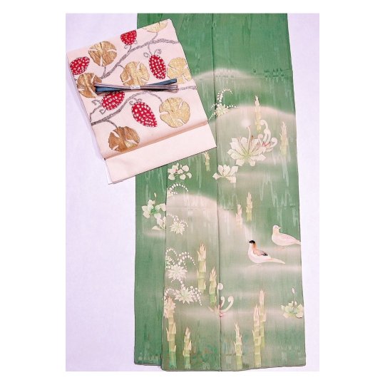
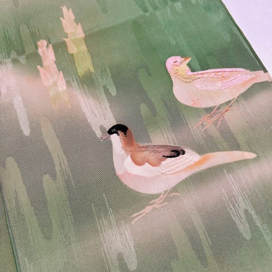


Springtime antique outfit, featuring a delicate irotomesode showing little birds among budding wild plants* (bracken, dandelion, horsetail, etc.). OP paired it with a glimmering strawberry obi.
*those could be referencing sansai (lit. "mountain vegetables", ie. edible plant foraged in the wild), as bracken and horsetail for example are a springtime delicacies in Japan:
youtube
youtube
#japan#fashion#kimono#obi#spring in japan#bracken#fern#warabi#dandelion#tanpopo#strawberry#ichigo#tsukushi#tokusa#horsetail#sansai#mountain vegetables#foraging#着物#帯#Youtube
122 notes
·
View notes
Text

Strawberry Moonrise Summit
#digital art#illustration#full moon#strawberry moon#moonrise#mountains#procreate#drawing#wall art#wallpaper#art#artists on tumblr#aesthetic#landscape#naturecore#original art#nature drawing#art on tumblr#trees and forests#mountaincore#mountainscape#moonscape#my art#art therapy#artist#serene#illustrator#illustrators on tumblr
61 notes
·
View notes
Text


"Why do people climb mountains? Is it just to reach the top and see the view?"
The Mountain Song | Tophouse
Model: Matt Dubbe
47 notes
·
View notes
Text

Mount Celeste 🍓
137 notes
·
View notes
Last Seen Blogs

favela-inquieta
Whisky e Gelo 🥃

aspiring-holistic-otaku
is this thing on?

myeverydayadventures
Everyday Me
myeverydayadventures
Everyday Me

bangtan-honey
𝐫𝐚𝐧𝐝𝐨𝐦 𝐜𝐡𝐢𝐥𝐝