#blue map
Explore tagged Tumblr posts
Visit Tumblr Blog
Explore Tumblr blogs with no restrictions, modern design and the best experience.
Last Seen Tumblr Blogs


Fun Fact
Tumblr has 16.74 million mobile monthly users in the US.
Text
Blue Dotted World Map Business Card

#worldmap#dotted#blue map#map#designbusinesscard#graphicdesign#businesscard#businesscarddesign#custombusinesscard#zazzlemade
1 note
·
View note
Text


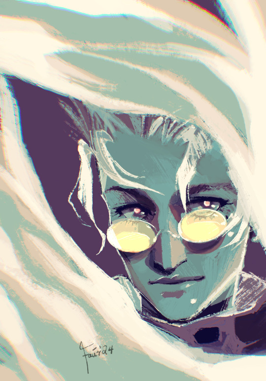
blue sargent is a hypocrite
#my art#trc#the raven cycle#trc fanart#blue sargent#gansey#henry cheng#bluesey#ladies call me the Gradient Map guy
2K notes
·
View notes
Text

The "Blue Map" of the World, 1811, by Huang Qianren.
An extraordinarily rare cartographic document that is based on research originally presented to the Qianlong emperor by Huang Qianren (fl. 1760- 70) in 1767. The title of the map is as much a political programme of the Qing as it is a geographical record. It shows China at the height of the Qing empire, celebrating the “unified status of all of Chinese borders” (Pegg).
“[This] ‘complete’ map minimizes the European notion of a map of the world, its centralized and marginalizing construct confirming the Qing/ Chinese notion of the Central Kingdom” (Pegg).
The map was designed to act not only as a grand political statement of the Kingdom’s place in the world, but also as an administrative tool. Its surface is dotted with provincial capitals (sheng), a square with a small rectangle on top; prefectures (fu), a square; independent district magistrates (zhilizhou), a square with a triangle on top; departments (zhou), a vertical rectangle; sub-prefectures (ting), a diamond; districts (xian), a circle; frontier passes (guan), a small building; local headmen or western tribute states (tusi), a triangle; with the name appearing within each pictogram. The borders of each province are denoted by dotted lines.
As well as administrative areas, the map depicts topographical and geographical information. Much attention is given to the waterways: the source of the Yellow River is correctly located in the Bayan-har mountain and is accompanied by an expansive explanatory note; the Minjiang River is given as the source of the Yangtze. Mountain ridges and the Great Wall are depicted in elevation, and desert areas are stippled. Several neighbouring countries are marked including Russia, India, Siam, Vietnam, Japan, and, most notably, Korea, who, as the chief vassal state, receives a great deal of commentary.To the upper left of the map are both the Mediterranean or “Small Western Ocean”, and Atlantic or “Great Western Ocean”, with Holland and England depicted as islands in the Atlantic.
One of the more striking aspects of the map is that the “intentionally vague geopolitical lines of the [empire’s] frontiers and beyond clearly indicate the Qing’s perception of the world around them … [when] … all foreign entities simply inhabited the fringes of the empire” (Pegg). This together with the empire’s size reaffirms the status of the kingdom as the geographical, political, and cultural centre of the world.
The map which the present example is based upon was first produced in 1767 for the Qianlong Emperor to celebrate the unification of the Qing empire. No example of the original survives. However, a painted copy of the map was produced in 1800 by Huang Zhengsun, and now resides in the Beijing National Library.
The map was then revised and enlarged in around 1811, resulting in the present work. This version was printed in two colours: blue and white, and black and white. There are examples of this version in the Maclean Collection in Chicago, the Library of Congress, and the Beijing National Library.
--
Richard A. Pegg, Cartographic Traditions in East Asian Maps (Hawai'i: Maclean Collection and University of Hawai'i Press, 2014), 18-27
Yan Ping et al., China in Ancient and Modern Maps, (London: Philip Wilson for Sotheby's Publications, 1998), 141.
0 notes
Text
Superman is asked in an interview if he walks around without his costume in the streets, he says yes, that he has perfected the way to disguise has a regular human, they ask for an example of one of his costumes so he grabs a black jacket and puts it on before slouching, warping himself in his cape and using his fingers to make little ears*
Superman (in grave voice): "I'm the night. *stretching the i* people think I live in the shadows, but I'M the shadows. I'm Batman *this continues for a couple of minutes, after that, the interview ends without problems*
...
Next morning all signs of Superman in Metropolis have been vandalized, either by painting bats as moustaches or by painting Batman's suit and cowl over Clark's faces
Later, he realizes all his suits have been replaced with Bat-suits bought from a Halloween costume shop, the Planet's windows were covered with photos of Batman and his kids wearing the suits they stole (plus masks), the internet is full of Superman memes and there's a viral video of Batman seemingly flying like Superman, in Superman's suit, while still wearing the Bat-cowl, only for the image to pull back and show Batman strapped to the Bat-mobile's roof, that's being driven by Spoiler, who is cackling like an Arkham inmate.
#batfam#batman#dc comics#dc robin#bruce wayne#dick grayson#jason todd#tim drake#damian wayne#barbara gordon#luke fox#harper row#cullen row#cassandra cain#stephanie brown#maps mizoguchi#alfred pennyworth#dc red robin#red hood#nightwing#blue bird#black bat#batkids#bat family#batgirl#oracle#bat-wing#superman
2K notes
·
View notes
Note
cogless megatron gives the same vibes as scourge from warrior cats and i’m living for it


I saw the word warrior cats and was violently taken over by my 5th grade self. Anon your mind
#transformers#maccadam#d-16#Megatron#tf one#soundwave#starscream#shockwave#warrior cats#I suppose#transformers one#sentinel would be tigerclaw obv#if he was less upfront abt his bloodthirst#that bitch is NOT chosen by starclan and did not get 9 lives#d-16 would be like ravenpaw but ends up in the streets instead of the barn#like that one warrior cats map pirate scourge or smth#my friend has actually been rereading the whole warriors series so this is great timing lol#who am I suppose to info dump a warrior tfo crossover to huh#smashing intrests together like barbies#rip starscreams fur#soundwaves a Russian blue starscream is long hair calico shockwave is a domestic longhair megs is shorthair#this isn’t research this is based on instinct#soap ask
911 notes
·
View notes
Text
#red white and royal blue#rwrb#alex claremont diaz#firstprince#henry fox mountchristen windsor#rwrb fanart#rwrb movie#henry hanover stuart fox#my art#rwrb art#henry fox#mwah#i kinda love gradient maps even tho idk how to use them properly
1K notes
·
View notes
Text


Some photos I took at the museum yesterday and decided to draw skeletons into, if I have to go somewhere all my blorbos have to go too
#UTDR#UTMV#My Art#Dadmare#Dust Sans#Killer Sans#Cross Sans#Dream Sans#Nightmare Sans#You can decide your own lore for their museum trip#Horror and Blue were there too but I ran out of pictures I could draw them into#Just assume Horror was mostly the one taking pictures and Blue was busy reading all the exhibits and holding the map#(Except for the one calling Cross and Killer gay. that was Dust if you can believe it lol)
374 notes
·
View notes
Text


Vashwooders how we doing tonight (cleaned up these traditional lyric sketches because its been too long since i posted these guys)
#song is dead friend by against me! btw#the crusty quality is a style choice i swear. and definitely not just the gradient maps fault#the original sketches were illegible okay i had to clean it up. the red sketch was far too visible underneath the blue lineart#trigun#trigun fanart#vash the stampede#nicholas d. wolfwood#vashwood#my art#trigun maximum spoilers
277 notes
·
View notes
Text
[Day 126]
Anticipation
#capochin#great god grove#daily capo#id in alt text#his outfit is really blue in this one i kinda like it#diligently working on my rumpus map part so ive done a lot of lineart today
197 notes
·
View notes
Text
stop the count!!!!!!!!!
#touhou#ok that's it for election posting. im done.#i realized after posting this that i could’ve just made it blue.#i didn’t have to spend half an hour inspect element editing the html on this map to make it green.
419 notes
·
View notes
Text

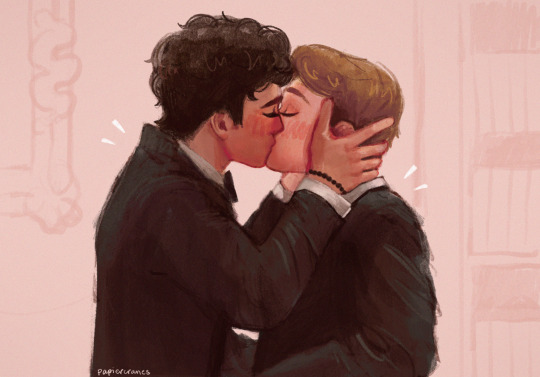
timmy! as he poses in front of the mirror like a giant nerd 💙

alt version + full panels below

#enjoy a blue nerd ass tim w lil mullet#love me a gradient map#tim drake#tim drake robin#robin#dc robin#robin tim drake#dc fanart#dcu fanart#robin fanart#tim drake fanart#dc#dc comics#dcu#crow-eyed-art#artists on tumblr
380 notes
·
View notes
Text

idc if he has more polygons PUT HIM BACK!!!!!
#Unleashed - Forces - Frontiers. 3rd 2nd and highest polygon counts for Sonic's game models.#and yet. I think its clear which one actually looks the best#ignore Frontiers missing his pupils his eyes are procedural maps in that game they dont have a diffuse texture#shade of blue keeps getting uglier too </3#hydro.txt
257 notes
·
View notes
Text
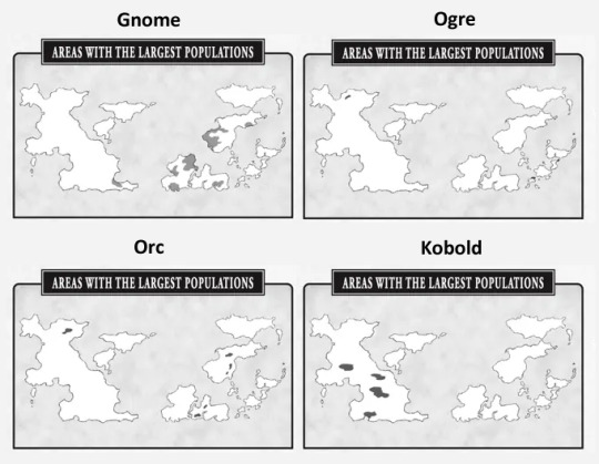
Racial Distribution world map
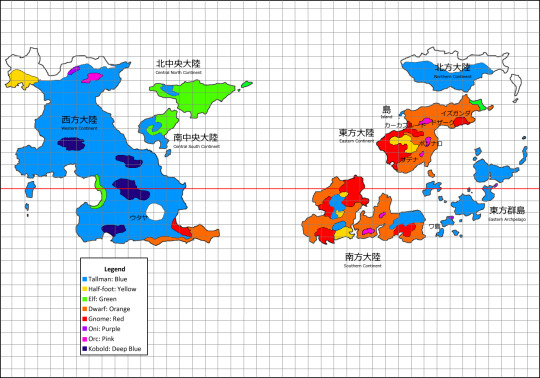
Map based on the population majorities living in the Dungeon Meshi World
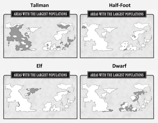
Map from this pixiv post and was created based on the "Areas with the largest populations" mini maps from the adventurer's Bible.
Legend Translation by @heattth Thank you!
Mini maps and addional map under the cut.
Adventurer's Bible mini maps
Religious Distribution (non Canon)
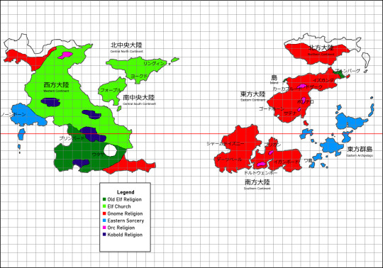
This map shows the religious distribution on the world map, but I'm not sure what its based on. I believe it's a headcanon.
edit: checked with some friends and indeed the (妄想) at the description of the pixiv post indicates this one isn't canon
#dungeon meshi#adventurers bible#dungeon meshi map#maps#for referencing#fantasy map#the hole where Utaya used to be...#Tallmen#Half-foots#Elves#Dwarves#Gnomes#ogres#Oni#Kobold#Worldbuilding#non canon#I edited the first map a bit cause some parts were bothering me#especially the red and dark blue
833 notes
·
View notes
Text
"but i’ve kissed your mouth, that corner, that place it goes, so many times now. i’ve memorized it. topography on the map of you, a world i’m still charting."
#firstprince#red white and royal blue#firstprince fanart#rwrb#rwrb fanart#rwrb movie#alex claremont diaz#henry fox#henry fox mountchristen windsor#taylor zakhar perez#nicholas galitzine#art#artists on tumblr#my art#fanart#i have nothing new but a study#but it's 'bad metaphors about maps' anniversary today and I wanted to celebrate#and that's my favorite frame from the movie so#:')
2K notes
·
View notes
Text

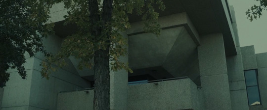


Come True Anthony Scott Burns. 2020
Sleep Study 111 89 Ave NW, Edmonton, AB T6G 2H5, Canada See in map
See in imdb
#anthony scott burns#come true#eye patch#julia sarah stone#landon liboiron#canada#calgary#alberta#university of alberta#brutalism#blue#sleep study#sleep#dream#edmonton#movie#cinema#film#location#google maps#street view#2020
280 notes
·
View notes